Browse Houses
Search Results: Returned 5926 records. Displaying results 5101 – 5200
| House name | Description | |
|---|---|---|
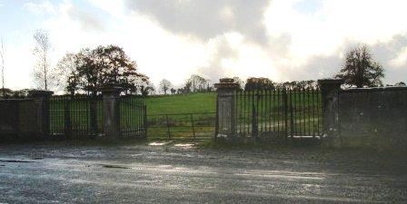
| Ryehill | Ryehill House was built in the early part of the 19th century and was still occupied in 1906 by a member of the Roche family. Unroofed in the mid 1950s only the impressive gateway and yard buildings still remain. |
|
| Ryninch | Lewis records J. O'Brien of Ryninch and Jeremiah O'Brien held a house valued at £10 and 115 acres from Francis Spaight in the mid 19th century. There were quarries in this townland. | |
| Ryves Castle [Castle Jane] | Ryves Castle, previously known as Castle Jane, was the home of the family of this name in the 18th and early 19th centuries. It is referred to as Castle Jane by Wilson in 1786 when he notes it as the seat of Mr. Ryves. By the 1830s however William H. Ryves of Ryves Castle appears to have moved to live in Brighton, as the birth of many of his children is recorded in the Limerick newspapers as having taken place there. In 1826 Fitzgerald records Ryves Castle as the residence of John Lowe. Lewis referring to the parish of Knocklong, notes that Thaddeus R. Ryan was resident at Castle Jane and that there was a vault of the Lowe family located in the grounds of Ryves Castle, that family having previously been its proprietors. For the parish of Ballyscanlan he records Ryves Castle as the residence of P. [T?] Ryan. At the time of Griffith's Valuation the house was valued at £29 and occupied and held in fee by William H. Ryves. In 1906 it was valued at £31 and was occupied by Thomas J. Franks. Later owned by Mr D. Fleming, this house is now demolished. | |
| Sackville House | William T. Crosbie was leasing this property to Sarah Heck at the time of Griffith's Valuation, when it was valued at £22 10s. Lewis records it as the property of the Crosbie family but resided in by Rev. R. Maunsell in 1837. Leet, in 1814, noted Sackville as the residence of John Saunders. In 1786, Wilson mentions Sackville " a very neat house, newly erected" as the seat of Rev. Thomas Graves, Dean of Ardfert. In 1906 it was the property of L.T. Crosbie and valued at £25. Bary states that Sackville was built by Thomas Graves, dean of Ardfert, in 1788, as there was no Glebe house there. It was named for Diana Sackville, wife of John Crosbie, second Earl of Glandore. It was leased by the Crosbies or lived in by one of the family for much of the nineteenth century. It was sold in the twentieth century and demolished in the 1950s. | |
| Saffron Hill Cottage | Hajba writes that this house was built in the first decade of the 18th century by Reverend Edward Sayers, rector of Templeroan. An Edmund Sayers is recorded as the occupant in the early 1850s. He held the property from Viscount Doneraile. The buildings were valued at £22. The Sayers estate at Croghnacree was advertised for sale in November 1859, November 1864 and May 1865. In 1906 Lord Castletown was recorded as the occupier. This house, an eleven bay single storey building, ceased to be a residence in the mid 20th century but has since been restored and is now inhabited again. Reference to the Sayers family in the Moore sale rental of 27 Feb 1863. This house is also associated with the Brasier Creagh family. |
|
| Salem Cottage | Located on the Barrett-Lennard estate, valued at £10 in the 1850s and occupied by James Gregg. James Gregg, farmer, of Clondregole, a townland adjacent to Mullanamoy, died on 15 September 1896 (NA, Wills and Administrations, 1897). A building is still extant at this site. | |
| Salisbury | Stephen Moore is recorded as resident here in 1814 and T. Sadlier in 1837. The christian name of the mother of Stephen Moore was Salisbury. By the time of Griffith's Valuation John Bagwell held the house in fee. It was valued at £18+. Percy Gough of Salisbury, Clonmel, owned 724 acres in King's County in the 1870s. Slater refers to "Inislonagh House" as the seat of Lt-Gen. Sir Charles J. Gough in 1894. Bence Jones writes that this house was leased to J.W. Cleeve in the early 20th century and from the late 1920s to Sir David O'Brien 6th Baronet. |

|
| Sallaghagrane House | John R. Boyd was leasing this property from Viscount Southwell's estate at the time of Griffiths Valuation in the 1850s, when it was valued at £35. The house at the site now is later, possibly built in the 1870s. |
|
| Sallowglen | William Sandes was leasing this property to Thomas Sandes at the time of Griffith's Valuation, when it was valued at £24. Lewis notes it as the seat of T.W. Sandes in 1837 as does Leet in 1814. Wilson, writing in 1786, refers to "Sallow Glin, the new and handsome house of William Sandes". In 1906 it was the property of Thomas W. Sandes and valued at £50. Bary writes that it was resided in by the Sandes family and their descendents until the 1920s when the estate was sold. It has since been demolished. | |
| Sallybrook | James Marshall was leasing this property from the Earl of Wicklow's estate at the time of Griffiths Valuation in the 1850s. It was then valued at £15. In 1906 it was the property of Samuel Marshall and valued at £12. The site appears to be occupied by farm buildings now. | |
| Sallyfield | A Hanly home from at least 1749 but by the 1850s held by George Lawder in fee. It was described at this time as a steward's house with offices and a lodge, valued at £3. It is labelled on both the 1st and 25-inch edition Ordnance Survey Maps as Sallyfield. It is no longer extant. A house named Cottage was also in the townland of Lavagh at N005 895 on both maps. | |
| Sallymount | Sallymount facing a plantation is named on the 1st edition 6 inch Ordnance Survey map (1836). In the 1830s it was the home of T. Robinson. At the time of Griffith’s Valuation the buildings were valued at £8 and John Woods was the occupant, holding the property from John Maxwell, whose estate was at that time being administered by the Court of Chancery. Home of the Assistant County Surveyor James Smith in 1911. He held the house from John McMahon. A building is still located at this site. | |
| Sallymount | Home of Lewis Atkinson in the early 19th century. At the time of Griffith's Valuation the house was leased by Edward Atkinson from the Wingfield estate when it was valued at £4. The site is now occupied by farm buildings. | |
| Sallymount House | Sallymount House is a three-bay two-storey house with dormer attic, dating from the early 19th century. It was the home of the Rotheram family for much of the 19th and 20th centuries. The Rotherams acquired it from the Nugent family. G S Rotheram was resident in 1837 and Griffith’s Valuation (publ. 1854) records George Rothram as the occupant holding the house valued at £35 from Priscilla Nugent. Members of the Rotheram family owned 560 acres in the 1870s. The estate was acquired by the Land Commission in the early 1960s and the house became derelict but has been restored recently. | |
| Sallyview | Sallyview is mentioned in The Parliamentary Gazetteer of 1846 but no occupant is given. The building is marked on the first edition OS map and named Sallyview although altered in shape on the 25 inch map. Valued at £14.10 at the time of Griffith’s Valuation (publ. 1854), occupied by John and Christopher Plunkett and held from Michael Plunkett, now a green field site. | |
| Sallyville | The Ordnance Survey Field Name Book describes Sallyville as ‘a cottage with a garden and very extensive orchard at present much out of order, the residence of Mr Breakey’. It was named on the first edition Ordnance Survey map (1836). Griffith’s Valuation records a steward’s house, offices and lodge in Lisnagalliagh, valued at £10, occupied by David R. Goodlatt and held from William Watson. These buildings were at a different location and by the mid-19th century Sallyville appears to be no longer in existence. | |
| Salrock | Built by Colonel Thomson in the early 1830s and occupied by his descendants ever since. In September 1836 Robert Graham refers to Colonel Thomson's "very pretty residence" although he did not actually visit Salrock. A major renovation is currently taking place. |
|
| Salterbridge House | The current Salterbridge House was mainly constructed in 1849 but incoroporated an eighteenth century house. Wilson, writing in 1786, refers to "Salta Bridge" as the seat of Richard Musgrave, "remarkable for its extensive orchards". At the time of Griffith's Valuation it was the residence of Richard Chearnley and valued at £68. In 1906 Salterbridge was owned by Henry P Chearnley and valued at over £70. The house remained in the family until the 1950s and subsequently became part of the Wingfield estate. It is still extant and open to the public at certain times. An associated gate-lodge is available for self-catering accommodation through the Irish Landmark Trust. See www.irishlandmark.com. |

|
| Salthill House (Inver) | Robert Russell was leasing this property from the Conyngham estate at the time of Griffith’s Valuation when it was valued at £20. It is still extant and occupied. A smaller property, labelled Sea View, is shown on the shoreline adjacent to the main house on the 1st edition Ordnance Survey map but is not labelled on the later editions. |
|
| Sanders Park | Late 18th century house, the seat of the Sanders family, occupied by William Saunders in 1814 and by C. Saunders in 1837. Griffith's Valuation records William R. Saunders holding the property from the Earl of Cork, the buildings were valued at £34+. The Irish Tourist Association Survey of the 1940s stated that it was then the residence of Mr. Binchy, a merchant in Charleville. It was converted into flats in the latter half of the 20th century but the building was derelict at the beginning of the 21st century. Also known as Charleville Park. |
|
| Sandfield House | Wilson notes this house as the seat of Mr. Sandys in 1786. The residence of Robert Sandes in 1814 and occupied by Bernard Reilly and valued at £3.10s at the time of Griffith's Valuation. A house is still extant at this location. | |
| Sandfield Lodge | Knocknaraha was originally O'Brien property. The house Sandfield Lodge was occupied by James Lysaght in 1814 and by the Right Honourable Baron Richards at the time of Griffith's Valuation. Baron Richards was leasing from Captain Francis Macnamara. The house is still extant and now the home of the Lucas family. |
|
| Sandville | The home of the Barry family in the 18th and 19th centuries, the house became known as Sandville in the early 19th century. The Ordnance Survey Name Book dates the building 1799. John Barry occupied this house on the Kelly estate at the time of Griffith's Valuation when the buildings were valued at £26. John Grene Barry was resident in the 1870s and 1880s. Buildings are still extant at the site. | |
| Sandville | This house valued at £13 was occupied by Mary Sullivan and held from - Roberts at the time of Griffith's Valuation. Hajba writes that it was occupied by Mrs Ellen Punch in 1910. It was bought by the racing trio of Sangster, Pigott and O'Brien in the late 1960s. The house was demolished and the property became a stud farm. | |
| Sandville House | Robert A. Thompson was leasing this property from the Herbert estate at the time of Griffith's Valuation, when it was valued at £11 5s. Bary notes that it had been frequently occupied by agents to the Herbert estate through the nineteenth century. It is believed to have been built by them in the late seventeenth century. The house is still extant and occupied. | |
| Sandy Hill | Home of the Reverend John Orpin in 1814, by 1837 this house was the residence of Thomas S. Coppinger and remained a Coppinger home for the rest of the 19th century. Located on the Hedges White estate it was valued at £9 in the 1850s. In 1944 the Irish Tourist Association Survey reported that it was the residence of Timothy Lucey, solicitor. There is still an extant house at the site. | |
| Sandycove House (Kinsale) | Sandycove House was being leased to John Gillman by Anne Stubman at the time of Griffith's Valuation, when it was valued at £12. It is labelled Atlantic Villa on the 25-inch map, published in the 1890s. | |
| Sandymount (Cordangan) | In 1840 the Ordnance Survey Name Books refer to Sandymount House "in good repair", part of the estate of James Sadlier. By the time of Griffith's Valuation, it was being leased by F.J. Mansergh from the Smith-Barry estate and valued at £7 5s. Buildings are still extant at the site. | |
| Sans Souci | A seaside residence, occupied by the Reverend John Westropp in 1814 and 1837, rector of Ballyvaghan. It later belonged to the Comyn family, now demolished. |
|
| Sapperton House | Held in fee by the Moore estate at the time of Griffith's Valuation, when it was valued at £37. It is described as a farm-house. Lewis refers to it as the seat of S. Moore in 1837. Wilson, writing in 1786, notes Sapperton as the seat of Major Moore. It was inherited by Willam Percival Maxwell. In 1906 he was the owner and the house was valued at £37. Sapperton, as well as its extensive farmyard, is still extant and occupied. |
|
| Sarahville | In 1851 held in fee by Richard Barron when it was valued at £25. James Barron of Sarahville is named in the will of Pierce Barron, dated 1808. James' wife was Sarah Gee. There is still a house at this site. | |
| Sarsfieldscourt [Old] | In 1837 Lewis refers to Sarsfieldscourt as an ancient mansion "formerly belonging to the Sarsfield family but now to Mr Rutland [Putland] of Dublin". On the first Ordnance Survey map one building is marked as "in ruins". Another building also named Sarsfield's Court is marked closer to the Glashaboy River. At the time of Griffith's Valuation Charles Putland junior was recorded as occupier, holding the house valued at £13 from his father Charles Putland. This latter property is labelled Beechmount on the 25-inch Ordnance Survey map of the 1890s. A property labelled Sarsfieldcourt House is also located in the townland on the later map [W723779]. It is no longer extant and St.Stephen's Hospital now occupies the grounds. | |
| Scalaheen | In 1840 the Ordnance Survey Name Books describe Scalaheen as "a very large house pleasantly situated on a hill, the residence of Richard Sadlier". William Sadlier occupied this house which he held from Nicholas Sadlier at the time of Griffith's Valuation. It was valued at £30. This house, which was located on the outskirts of Tipperary town, no longer exists. | |
| Scart | The residence of Robert Croker in 1814 and of Henry Rice in 1837. The Ordnance Survey Name Books refer to it as his residence in 1840, "pleasantly situated on rising ground and in good repair". In the early 1850s Rice held the property from John Bagwell and the buildings were valued at £12+. Henry Rice may have been a son-in-law of Robert Croker. see http://members.iinet.net.au/~nickred/croker_research/The_Irish_CROKER.pdf A building is still located at this site. | |
| Scart | James F. Bland was leasing a house valued at £10 15s to William Jermyn at the time of Griffith’s Valuation. Bary states that Scart house was occupied for several generations of the Jermyn family before being sold in the 1890s. It is still extant and occupied. |
|
| Scart Cottage | Thomas Hely was leasing this property from Christopher Griffith in 1851, when it was valued at almost £8. A house still exists at this site. | |
| Scartagh Cottage | Tradition locally suggests Scartagh Cottage was originally the property of the Townsend family. By the time of Griffith's Valuation, it was being leased by Henry Galway to Matthew O'Hea. Various members of the Galway family held small amounts of land in the area while Matthew O'Hea, of the War Office, London, is recorded as the owner of 70 acres in county Cork in the 1870s. Scartagh Cottage has been replaced by a convent on the 25-inch Ordnance Map towards the end of the nineteenth century and that building is still extant. | |
| Scartbarry | Home of the Wilson family in the 19th century, occupied by Edward Wilson in 1814 and by Ellen Wilson in the early 1850s, when the house was valued at £11 and held from James H.S. Barry. Edward Wilson of Scartbarry owned 26 acres in the 1870s. This house is still a family residence. The interest of the descendants of the Wilson family of Scartbarry and of James Milner Barry in the lands of Skehannagh and Coolequane, barony of Barrymore were offered for sale in the 1850s. |

|
| Scarteen | Thaddeus R. Ryan was resident at nearby Castle Jane [Ryves Castle] in 1837 as recorded by Lewis and Scarteen was unoccupied. John Ryan was the occupier of Scarteen in the early 1850s when the house was valued at £30+. He held the property from William H. Ryves. His widow Alice owned 50 acres in county Limerick in the 1870s. The Ryans still live at Scarteen where the famous pack of hounds of that name is kennelled. |

|
| Scartnamuck House | Benjamin Popham was leasing this house from the Devonshire estate at the time of Griffith's Valuation, when it was valued at £25. It is also noted by Lewis as his residence in 1837. The house is still extant. |

|
| Scarvy House | Scarvy was the home of Major Campbell Graham in the 1830s. About this time the original house, which is marked on the 1st edition 6 inch Ordnance Survey Map (1836), was replaced by a new one. The Ordnance Survey Field Name Book records ‘Near the centre of the townland there is a good house with large orchards, gardens etc belonging to the proprietor but it is going to be replaced by a larger one near the same spot which is now building.’ By about 1860 the buildings were valued at £38 and held by Lydia Campbell from Thomas de Burgh. Occupied by the Duggan farming family in 1901. Not occupied in 1911 but still held by Colonel de Burgh. |
|
| Scilly | At the time of Griffith's Valuation, Rev. William Newman was leasing this property to George Dawson, when it was valued at £24. It included stores. |
|
| Scilly House | John G. Daunt was leasing Scilly House to Major Black at the time of Griffith's Valuation, when it was valued at £15 5s. It is still extant and offers holiday accommodation in the grounds. | |
| Scor More | At the time of Griffith's Valuation, Scor More was leased to Patrick Beirne by the Lloyd estate and was valued at £3. 100 acres was also leased. This house is not shown on the 1st edition of the OS map. | |
| Scrahan | At the time of Griffith's Valuation, Thomas Shanahan was leasing this property from the Marquis of Waterford's estate when it was valued at £14 10s. An extensive farm complex exists at the site. | |
| Screeb Lodge | A shooting and fishing lodge built by the Berridge family in the latter half of the nineteenth century and now run as a guest house. See www.screebe.com |
|
| Scregg | A Kelly home built in 1767, occupied by J.E. Kelly in 1837 and Eliza Kelly in the 1850s. In the sale rental of 1856 the house is described as a respectable mansion, 3 stories high with basement and attic stories and a view of the Shannon River. Occupied in 1906 by the representatives of Henry Potts. The house is extant but no longer lived in. It is currently (2009) being restored with support from the Irish Georgian Society, see http://www.igs.ie/Programmes/Conservation-Grants/Scregg-House.aspx |
|
| Scurmore | In 1786 Wilson writes that Scurmore House was the seat of Mr. Nisbett. Later, in the nineteenth century it became a seat of the Wingfields. In the 1830s it is described as undergoing repairs but the family were again occupying it by 1857. The house is recorded as the property of S.L. Lewis in 1906 when it was valued at £37. McTernan states that the house was demolished in the mid twentieth century. A later house now exists at the site but the original outbuildings are still intact. | |
| Sea View (East Carbery) | Howard Wiseman was leasing this property to William Merrick at the time of Griffith's Valuation, when it was valued at £10 10s. It is still extant and occupied. |

|
| Sea View (Inishowen) | Caldwell Motherwell and Thomas Black were leasing this property to Alexander Henderson at the time of Griffiths Valuation in the 1850s, when it was valued at £20. It is labelled Sea View on all editions of the Ordnance Survey maps but is no longer extant. | |
| Seacourt | Henry Longfield held this property in fee at the time of Griffith's Valuation, when it was valued at £21 5s. Lewis also refers to it as his seat in 1837. In 1906 it was owned by Mountifort Longfield and valued at £26 10s. It is still extant and was recently for sale see http://www.michaelhdaniels.com/ |

|
| Seafield | The home of Mr John Hudson in 1814 and of Thomas Seward in the early 1850s. Seward held the property from Lord Stuart de Decies and it was valued at £24. The National Inventory of Architectural Heritage suggests it was built in the latter decades of the 18th century. It has recently been under renovation. |
|
| Seafield | At the time of Griffith's Valuation, this property was held in fee by Robert McMunn. It consisted of a herd's house, valued at 10s and 75 acres. Later, as Seafield House, it was the residence of James McMunn,MD. In 1906 James McMunn, M.D. is recorded as the occupier of property at Killeenduff townland, barony of Tireragh, including a mansion house. Seafield was derelict for some time but has recently been restored. |
|
| Seafield | Seafield House is no longer extant though evidence of walled gardens and out buildings are still visible. It was the residence of Robert Blake in 1814. In 1824 it was the residence of Henry Blake who offered it for letting in the ''Connaught Journal'' in May of that year. The Ordnance Survey Field Name Books noted Seafield as the residence of Mr. Blake's steward. At the time of Griffith's Valuation it was leased by the Blake estate to Matthew Fynn and was valued at £6. | |
| Seafield (Decies) | In 1851 William Power was leasing this property from Peter Anthony when it was valued at £19. In 1906 the house at Seafield was owned by James Russell and valued at £22. Lewis had noted it in 1837 as the seat of P. Barron. There is still a house at the site. | |
| Seafield (Kinsale) | Rev. G. Nash was leasing this house from Thomas Banfield in 1851 when it was valued at almost £8. It does not appear on the 25-inch Ordnance map of the 1890s and no house exists at that site now. | |
| Seafield Lodge | The home of the Casey family in the late 18th and early 19th centuries. Occupied by William Casey in 1814. Leased by Captain Francis Casey to William Brew in the mid 19th century and it remained a Brew home until it was burned down in 1922. | |
| Seafield or Lisheen | At the time of Griffiths Valuation, William Phibbs owned a house at Lisheenacooravan valued at £55. This house was known as Seafield or Lisheen at different times. In 1906 Seafield/Lisheen was valued at £55. The property is now a ruin |
|
| Seafort | Mountifort Longfield was leasing this property to Stephen Browne at the time of Griffith's Valuation, when it was valued at £9 10s. May possibly have been owned by William Hull in 1814. In 1894, Slater refers to it as a residence of Mountifort Longfield. The house is still extant, together with extensive farm buildings. |

|
| Seafort House | At the time of Griffith's Valuation, Richard Wood was leasing a property valued at £14 at Carrowbrickeen, barony of Tireragh, from the representatives of Arthur Cooper. Lewis records Seafort House as a residence of the Wood family in 1837. In 1814 it was the seat of Richard Wood. McTernan notes that Seafort House was demolished in the twentieth century and a modern house stands at the site. | |
| Seamount | Seamount House was built by the Butlers of Cregg in the 18th century. O'Connell notes that Seamount was the residence of Maj. Theobald Butler, who had fought at the Battle of Waterloo, during the 1820s. At the time of Griffith's Valuation Denis Hynes was leasing from Edmund Donnellan, when it was valued at £16. Dr. Hynes had purchased the house from the Butler estate. In the early 20th century it was given to the Sisters of Mercy and is now a school. |
|
| Seamount | A house situated on the O'Brien estate, it was occupied by Charles O'Callaghan in 1814 and by the Right Reverend Dr Fallon, Bishop of Kilfenora, at the time of Griffith's Valuation, when it was valued at £18. Later it became the home of the Higgins family. The house was accidentally burnt in the early 20th century. | |
| Seamount House (Carrigaline) | Louisa Penrose, with several others, was leasing this property to James French at the time of Griffith's Valuation, when it was valued at £12. Henry Smith was leasing a property [W785625] valued at £10 from the same estate, also in Curraghbinny townland. In 1860, over 600 acres owned by members of the Fitzgerald family and others were offered for sale in the Landed Estates Court. The sale included Seamount House, in the possession of Henry Smith. | |
| Seamount House (Carrigaline) | At the time of Griffith's Valuation, this property was leased by James French from the Penrose estate when it was valued at £12. The property is labelled Seamount House on the 25-inch Ordnance Survey Map of the 1890s. There is still an extant house at this site. | |
| Seamount Lodge | The Clanmorris family had a residence in the Salthill area of Galway at Pollnarooma East parish of Rahoon, leased from Richard Sloper. It was valued at £21 at the time of Griffith's Valuation. A house named Seamount Lodge is marked on the first Ordnance Survey map in this townland. Seamount was the home of Sebastian Nolan of the Ballinderry family in the late 19th century. It was in use as a nursing home in the twentieth century before being demolished to make way for the housing estate of the same name. | |
| Seapark House | This property is described as a caretaker's house on Christopher St. George's estate at the time of Griffith's Valuation when it was valued at £8. O'Connell states that it was locally known as "Foy's House" and was used as a fever hospital during the famine. It is now in ruins. |
|
| Seaview | Home of Francis Goold Morony from at least 1837 until the 1870s. He held it from Burdett Morony. The house was valued at £21 and was surrounded by 5 acres. Later inhabited by the Ellis family and sold to the Sisters of Mercy in 1929. |
|
| Seaview (Decies) | In 1851, Anthony Fitzgerald was leasing this property from Lord Decies estate when it was valued at £18. Though the site is occupied by a farm this building does not appear to be extant. | |
| Seaview Cottage | At the time of Griffith's Valuation, John Bowen was leasing this property to William Bernard, when it was valued at £16. Lewis notes in 1837 that Mr. Bowen had built this and several other houses in the locality as bathing lodges. Leet mentions Seaview as the seat of John Powell in 1814. Seaview is now a stud farm. | |
| Seaview House (Kilmacrenan) | At the time of Griffith’s Valuation, Reverend Samuel O’Neill Cox was leasing this property from the Hill estate, when it was valued at almost £10. The map accompanying the valuation names it as Scarnamallagh Glebe House but it is labelled Seaview House on the 25-inch map of the early 20th century. Buildings are still extant at the site. | |
| Seaview House (Myross) | Col. W.F. French was leasing this property to Richard Kingston at the time of Griffith's Valuation when it was valued at £9 15s. The family were still resident in 1911. The house is still extant and occupied. |

|
| Seaview or Doonecoy | The Hillas family seem to have occupied the house at Carrowmacrory since the eighteenth century as McTernan notes that it was built by Robert Hillas who was High Sheriff of Sligo in 1772. Mrs. Esther Hillas was occupying the house, valued at £25, at the time of Griffith's Valuation. In 1906 it was the property of Robert G. Hillas and was valued at £23. The house was eventually sold in 1955 to the O'Beirne family by whom it is still owned. |
|
| Seaville or Seaview House | At the time of Griffith's Valuation James Kerr was leasing a house valued at £12 at Carrownurlaur from the Wingfield estate. It is labelled Seaville House on the First Edition Ordnance Survey map but as Seaview House on the later 25-inch edition of hte 1890s. Portion of the original building remains. | |
| Selloo | A building at this site is marked on the 1st edition Ordnance Survey map (1836) and named on the 25 inch map. In 1853 Selloo described as a 'convenient residence, placed in an ornamentally planted demesne, and also a corn mill, kiln etc' was advertised for sale in the Encumbered Estates Court by Joseph Whitsitt. This was the home of the Pringle family in the mid-19th century, valued at £18 and held in fee by William Pringle. The Hunter and Deering families occupied the house in 1901 and 1911 while Thomas A. Pringle was the landholder. It appears to be currently extant. | |
| Shaen Manor or Lodge | The residence of the Carter family or their agent, built on the site of the old glebe house at Logmore. Occupied at the time of Griffith's Valuation by John Crampton. The house was leased in 1877 to Gerald Henry Bingham and with 56 acres was offered for sale in the Landed Estates' Court in 1885. It is named on the 25-inch Ordnance survey map of the 1890s as Logmore House. The site is now a school. | |
| Shallee | The Youngs appear to have been located in Shallee from at least the mid 18th century. Leet records Mr Francis Young as resident in 1814. In 1840 and at the time of Griffith's Valuation Francis E. Young was the occupant, holding the property from George Cashin [Cashel]. The buildings were valued at £20+. The sale rental of 1868 refers to a lease dated 1853 from Edward Worth Newenham to George Cashel of Shallee House. A house is still extant at Shallee. | |
| Shanagarry | A house occupied by Thomas John Keane from at least 1837. At the time of Griffith's Valuation the buildings were valued at £16 and held from Peter Gaskell. T.J. Keane's representatives were still resident in the 1870s. Part of Shanagarry, the estate of Thomas John Keane, was advertised for sale in November 1876 and June 1877. In January 1881 this house and 58 acres was for sale again. The house had "hot and cold water laid through it". This house is still a family residence. |
|
| Shanagarry Castle | A tower house with additions, mainly associated with the Penn family. Probably the building occupied by Warham Durdin in 1814. At the time of Griffith's Valuation Thomas Durdin was in possession of most of this townland. In 1942 the Irish Tourist Association Survey referred to the Penn connection and stated that the house was then in the possession of the Brazier family. |
|
| Shanagolden House | According to the Ordnance Field Name Books this house was erected in 1812 on the site of a former house. This three-storied house was situated on the Monteagle estate and was occupied by John Griffin in 1814 and by the Reverend George Vincent, rector of Shanagolden in 1837. His son Arthur Vincent was resident in the early 1850s when the house was valued at £20 and in the 1870s when he is recorded as owning 267 acres in county Limerick. It is no longer extant. | |
| Shanagraigue | Richard Woodley held this property in fee at the time of Griffith's Valuation, when it was valued at £13 10s. Buildings are still extant at the site. | |
| Shanakiel | Daniel Leahy is recorded as the occupier of Shanakiel House in the first half of the 19th century. The house was valued at £85 in the early 1850s and held from the Earl of Cork and Orrery. This house no longer exists and its site is located in the grounds of a hospital. | |
| Shanakill (Decies) | In 1851, this property was leased by Edmund Dower from Thomas J. Fitzgerald when it was valued at almost £10. A house and farm are still extant at this location. | |
| Shanakill (Upperthird) | John Hearne was leasing this property from the Power estate at the time of Griffith's Valuation, when it was valued at £11 10s. Morris states that the Hearns had held an interest in this property since the 1720s. Financial difficulties led to its sale to Mary Anne Quin in 1866. In 1906 it was owned by Anne Ussher Quin and Frances Anne Quin and was valued at £18 10s. This house was also associated with the Labarte family. A house is still extant at the site. | |
| Shanbally | Shanbally was occupied by John Gasson in 1814 but had become the home of Peter Smithwick by 1837. He held the property from Samuel Gason in the mid 19th century when the house was valued at £26.13 shillings. The Ordnance Survey Name Books describe it as "a good dwelling house". In 1894 Slater refers to it as the residence of John Smithwick. It is still extant. |
|
| Shanbally | In 1786 Wilson refers to Shanbally as a seat of Viscount Lismore. It was occupied by John Mahoney and valued at £10.15 shillings at the time of Griffith's Valuation, held from Viscount Lismore. In 1894 Slater refers to it as a residence of Viscount Lismore. | |
| Shanbally | Hajba records this house as a Welsh/Walsh home. John Welsh was the proprietor in 1837. E.B. Roche is given as the occupier in the early 1850s when the house was valued at £11. He held the property in fee. The house is still a residence. | |
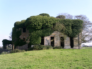
| Shanbally Castle | Bence Jones writes that this was the largest of John Nash's Irish castles, built circa 1812 for Cornelius O'Callaghan 1st Viscount Lismore. It was valued at £151 in the mid 19th century. Inherited by two daughters of the Marquess of Ormonde Lady Beatrice Pole Carew and Lady Constance Butler following the death of their cousin the 2nd and last Viscount Lismore in 1898. The Irish Tourist Association Survey in the early 1940s records that the building was taken over by the military authorities "for the duration of the present emergency". Sold by Major Patrick Pole Carew in 1954 and demolished in 1957. |

|
| Shanbally Cottage (Carrigaline) | Thomas Burke was leasing this property to Joseph Beaumont at the time of Griffith's Valuation. It was valued at £34 and included a mill. The latter, known as Rathanallig Mills (W751651), is described as "in ruins" on the 25-inch Ordnance Survey Map of the 1890s while the house is diminished in size and has since disappeared. There are still buildings on the mill site. | |
| Shanbally House (Moycarkey) | In 1786 Wilson refers to Shanbally as the seat of Colonel Slaughter. In1840 the Ordnance Survey Name Books note that "Shanbally Old Castle" was the name given to a house in the parish of Moycarkey. By the time of Griffith's Valuation the townland is part of the estate of Miss Emma Stannix. A house is still extant at this site, now part of a large farm. | |
| Shanballyard | Shanballyard House is marked on the first Ordnance Survey map. In the mid 19th century John Scully held buildings valued at £16+ and 299 acres from James Scully. The National Inventory of Architectural Heritage records this house as "disused". |
|
| Shanballymore | The seat of a branch of the Roberts family, Hodder Roberts was resident in 1814 and Watkins Roberts in 1837. The residence of John Roberts in the early 1850s, held from William W.M. Hodder and valued at £23. The property remained in Roberts possession until 1884 when it was sold to the O'Keeffe family who still reside there. |

|
| Shanboolard Hall | Built post 1838, occupied by E. Whitwell at the time of Griffith's Valuation and later by the Acheson family who were strong promoters of the Galway to Clifden railway. Bought by the Armstrongs in 1890s and in the possession of their descendants for most of the 20th century. Sold to Ashley Mathews following the death of Graham Tulloch in 1990. |
|
| Shandangan East | A house occupied by Patrick Hassett at the time of Griffith's Valuation held from Samuel Penrose and valued at £18.10 shillings. This property is labeled Larch Hill House on the 25-inch Ordnance Survey Map of the 1890s. It is still extant and occupied. |
|
| Shandangan House | Smith records Christopher Earbury as resident at Shandangan in 1750. Devonsher Esq was the proprietor of Shandangan in the 1770s and 1780s. A Mr Timothy Mahony was living at Shandangan, Macroom in 1814. Lewis records S. Penrose as the proprietor of Shandangan (parish of Kilmurry) in 1837 and Samuel Penrose was still occupying the house at the time of Griffith's Valuation. He held it in fee and it was valued at £13.10 shillings. | |
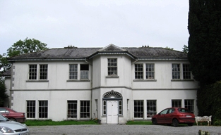
| Shandon House | ||
| Shandon House | In 1851 James Broderick was leasing a property valued at £10 at Shandon, parish of Dungarvan. In 1774 Smith noted Shandon House as "formerly having been a seat of the Hore family, now falling into decay". It is no longer extant. | |
| Shandy Hall | The Crosses were living at Shandy from at least the late 18th century. Lewis records P. Cross as the proprietor of Shandy Hall in 1837 and Philip Cross held the house valued at £33 and 106 acres from Colonel [Mair] at the time of Griffith's Valuation. Philip Cross of Shandy Hall is recorded in 1876. The Irish Tourist Association noted that a stone inscribed with the date 1758 existed at the house and also referred to its being "the home of Phillip Cross who murdered his wife and was hanged in Cork Jail" Shandy Hall is still extant and occupied. |
|
| Shandy Hall | Tristram Kennedy was leasing this property from the Cary estate at the time of Griffiths Valuation in the 1850s when it was valued at £16. It is labelled Shandy Hall on all editions of the Ordnance Survey maps but is now a ruin. | |
| Shannon (Raphoe North) | Samuel Gourley was leasing this property from the Erne estate at the time of Griffiths Valuation, when it was valued at £10. It is labelled Shannon on all editions of the Ordnance Survey maps. A farm is extant at the site. | |
| Shannon Grove | Shannon Grove was valued at £20 and was leased to Hubert Moore in 1855. William R. Seton was the owner of a house valued at £65 in the townland of Kilnaborris in 1906. Leet's Directory records Shannon Grove as the residence of Hon. B. Yelverton in 1814. A substantial house still exists at Shannon Grove. |
|