Browse Houses
Search Results: Returned 5926 records. Displaying results 4601 – 4700
| House name | Description | |
|---|---|---|
| Pegsborough House | In 1786 Wilson refers to Pegsborough as a seat of the Earl of Derby. Henry Smithwick was living at Pegsborough in 1814. By 1837 George Bradshaw was resident. The Ordnance Survey Name Books in 1840 refer to this house as the property of Lord Portarlington. In the early 1850s George Bradshaw held the property from Henry Smithwick. The buildings were valued at £23.5 shillings. A house is still extant at the site. | |
| Pella House | A Studdert home on the Vandeleur estate valued at £13 in the mid 19th century. Weir writes that the house was built by Admiral John Fitzgerald Studdert and it remained a Studdert home until 1900. Though a house is still extant at the site the original house is now ruinous. |
|
| Pembroke | The seat of Thomas Parsons Boland in 1837. Held in fee by him at the time of Griffith's Valuation, when it was valued at £48. Pembroke, together with many other of his houses, was included in the Sale Notice of Boland's estate in November 1859. It was offered for sale again in May 1868 when the house was noted as having "lofty and spacious rooms". In 1786 Wilson refers to Pembroke Town as the seat of Mr. Boland. In 1943 the Irish Tourist Association Survey noted that the Duke of Wellington was supposed to have stayed at Pembroke prior to embarking for the Peninsular wars. The house is no longer extant and a housing development has been built on the site. | |
| Pembrokestown House | The house at Pembrokestown probably came into the Esmonde family through the marriage, in the eighteenth century, of Sir James Esmonde, seventh baronet, to Ellice White, daughter of Thomas White, of Pembrokestown. In 1814 Leet refers to it as the seat of William Power. At the time of Griffith's Valuation, in 1850, it was held in fee by Mrs. Anne Esmonde, and valued at £21. In 1894 Slater refers to it as the seat of Patrick W. Power. A house is still extant at Pembrokestown. It was offered for sale in 2025. |
|
| Pencil Hill | This house was built in the 1780s by Harmer Spratt who had married a member of the Foott family. It was known as Monte Video in 1837. The Spratt continued to live in the house untill the early 20th century when it was sold to the Perrott family. The Perrotts changed the name of the house to Beechfield and it was still the home of this family at the beginning of the 21st century. | |
| Peppardstown | The home of members of the Henderson family in 1814 and in 1850 when Samuel Henderson held a house valued at £10.14 shillings from Matthew Jacob at Peppardstown. In the mid 1870s Jerome James Guiry was living at Peppardstown, Fethard and the Guiry family were still resident in the early 21st century. The National Inventory of Architectural Heritage dates the present Peppardstown house from circa 1870. Beatrice P. Saunders was occupying the mansion house at Peppardstown in 1906. |
|
| Percymount | At the time of Griffith's Valuation John Wynne held this property at Kiltycahill, when it was described as "Painter's house" and valued at £5. The property had been owned by the Gethin family until its sale in the Encumbered Estates Court in the early 1850s. McTernan states that races were frequently held on the lawn at Percymount between the 1870s and the 1940s. The house is now in a derelict condition. | |
| Perssepark | At the time of Griffith's Valuation, William Persse was leasing a house valued at £10 from Dudley Persse at Perssepark, parish of Kilcloony, barony of Clonmacnowen. Earlier, in 1837, Lewis recorded Perssepark as the residence of S. Masters. Now the site of modern industrial development. | |
| Petersburg | An early 18th century house, the seat of the Lynch family in the 18th and 19th centuries. Wilson refers to it as the seat of Mr. Lynch on the shore of Lough Mask in 1786. In 1986 the house and immediate surrounds were vested in the county Galway Vocational Education Committee. The house and yard buildings have been completely renovated and now function as an Outdoor Education Centre. |
|
| Phale Court | At the time of Griffith's Valuation, Standish Smithwick was leasing this property from William Stanley, when it was valued at almost £8. It is recorded as Phale House on the 1st edition OS Map and as Phale Court on the later 25 inch Map. In 1837, Lewis refers to Phale House as the seat of E.H. Good. In 1914 it was occupied by the Hosford family. In 1786 Wilson refers to it as the seat of John Wade. It is also associated with the Deasy family. |
|
| Pheasant Hill | A Sheridan home from the late 18th century to the late 19th century. Wilson, writing in 1786, refers to "Dan" as the seat of Mr. Sheridan. By the time of Griffith's Valuation it was held by John Sheridan from the Earl of Lucan's estate with a valuation of £3. It is not shown on the 25-inch map of the 1890s and modern buildings exist in the area now. | |
| Philipston | In 1840 the Ordnance Survey Name Books refer to "Phillipstown" as "a house in a small demesne". It was the residence of Hugh Brady Bradshaw in the mid 19th century, held by him from the Reverend William Guinness and valued at £16.15 shillings. This house is still extant and lived in. |
|
| Pickle Point | In 1837 Pickle Point was occupied by - Cashe. At the time of Giffith's Valuation, Reverend John Jackson was leasing it from the Carter estate, when the buildings were valued at £12. A house is still extant at the site. | |
| Pilltown House | Declan Tracy was leasing this property from the Kennedy estate at the time of Griffith's Valuation, when it was valued at over £12. Smith refers to it as "Pilltown, not long since the estate of the Walshes". The house is labelled Pilltown House on the 25-inch map of the 1890s. It is no longer extant. Tracy is noted as the owner of over 450 acres in county Waterford in the 1870s. A substantial mill, valued at £39, in the same townland was being leased by Peter Moore Fisher [X129800]. It was included in the sale of Fisher property in the Landed Estates Court in November 1865. The mill appears to have fallen into disuse by the end of the nineteenth century though the ruins remain. | |
| Plassey | Built by Thomas Maunsell, founder of Maunsells' bank, Limerick, and occupied by him in 1814. Inherited by his daughter Mrs Robert Hedges Eyre Maunsell. Occupied by Reuben Harvey in 1837 and at the time of Griffith's Valuation. Harvey held the property from the trustees of Mrs Hedges Maunsell. The residence of Richard Russell in 1868. Home of John Norris Russell in the 1870s. Bence Jones writes that the present Plassey House is "a rambling two storey Victorian Italianate house built by the Russells". This house is now part of the University of Limerick. |

|
| Plaster (Kilmacrenan) | ||
| Plover Hill House | Sir Edward Denny was leasing this property to George Gunn at the time of Griffith's Valuaton, when it was valued at £16 5s. Lewis records it as the seat of George Gun in 1837. Bary states that the house was built in the early nineteenth century by Barry-William Gun, whose mother was Arabella Denny. The Gunn family continued to own the property until the 1880s. Buildings still exist at the site. | |
| Pluck | James B. Marshall was leasing this property from the Hayes estate at the time of Griffiths Valuation in the 1850s, when it was valued at £18. It adjoined a mill complex. The site is occupied by modern buildings now. | |
| Point House (Crosshaven) | Edward Sisk was leasing this house from the Puxley estate at the time of Griffith's Valuation, when it was valued at £10 10s.The house at the site is known as Point House and the National Inventory of Architectural Heritage suggests it was built in the mid-eighteenth century. |
|
| Point House/Cosheen | John Somerville was leasing Point House from Rev. M. Townsend at the time of Griffith's Valuation, when it was valued at £20. Lewis recorded it as the seat of R.B. Townsend in 1837. It is labelled Point House on the 1st edition Ordnance Survey map but as Cosheen on the 25-inch edition of the 1890s. It is still extant and known by the latter title. | |
| Pollranny | At the time of Griffith's Valuation, Henry Dillon Trant was leasing a property valued at £4 10s + 130 acres at Pollranny, barony of Castlereagh, to John Irwin. | |
| Poplar Vale | Home of the Richardson family in the 18th and 19th centuries, Lewis records Major E. Richardson as proprietor. The house is named on the 1st edition 6 inch Ordnance Survey map (1836) surrounded by parkland and an extensive walled garden. The buildings were valued at £30 circa 1860 when John Richardson was the occupier holding the property from Robert Ellis. Edward John Richardson was resident in the early 20th century. In the 1940s St Patrick’s Agricultural College was established at Poplar Vale. | |
| Port | Port is given as the address of Guy Cooper in 1814 while in 1856 the house at Port was occupied by George Latimer. | |
| Port | Home of the O'Loghlens in the latter part of the 18th century and first part of the 19th century. Hugh O'Loughlin was resident in 1814 and in 1837. The house was unoccupied at the time of Griffith's Valuation. Weir writes that the house and demesne were purchased by Jeremiah Kelly in the 1860s. |
|
| Port Hall (Raphoe North) | James Clarke was leasing this property from the Dogherty estate at the time of Griffiths Valuation in the 1850s, when it was valued at £35. The National Inventory of Architectural Heritage suggests it was built in the 1740s for John Vaughan and classifies it as a building of national importance. It is still extant and occupied. |
|
| Port Royal | At the time of Griffith's Valuation, Henry Griffith was leasing a property at Buninna, including a mill from the Cooper estate. The property was valued at £12. McTernan notes that this house is described in early nineteenth century documents as a "marine villa". It was later occupied by the McMunn and Hart families. It is stil extant but dilapidated. | |
| Porta Villa | Reverend Thomas McClelland was residing in a property leased from William McClelland at the time of Griffith’s Valuation. The property was valued at £18. This may be the property labelled on later maps as Porta Villa. It is still extant and occupied. |
|
| Portacarron | In 1786 Wilson refers to "Portacairn" as the seat of Mr. French. At the time of Griffith's Valuation, there is no house with a substantial valuation in this townland, then in the possession of Marianne Nolan. There is no visible sign of the house now, some walls and parts of the stable yard remain. |
|
| Portachappel House | Robert H. Nolan was leasing this property from Mrs. A. Carey [Cary}’s estate at the time of Griffiths Valuation, in the 1850s, when it was valued at £17 10s. The National Inventory of Architectural Heritage suggests that the house was built in the early 19th century but later altered. It is still extant and occupied |
|
| Portaliff House | Portaliff House was located on the Castle Hamilton estate, north of Mill Lough and a little south of Killashandra. In the mid-19th century it was occupied by Captain F.H.B. Philips when it was valued at £12 for rates. Portaliff House is listed as a protected structure. | |
| Portinaghy House | Buildings are located at this site on the 1st edition 6 inch Ordnance Survey map (1836). In the mid-19th century the house was valued at £18 and inhabited by Mary Campbell, who held the property from Charles P. Leslie. In 1876, the representatives of Mrs Mary Campbell, Portinaghy, owned 211 acres in county Monaghan. Home of the Edwards family in the 20th century. |
|
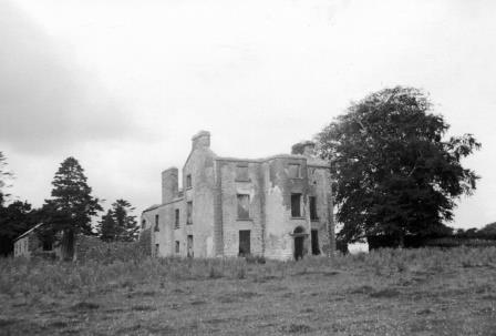
| Portland Park | A residence of the Stoney family from at least the 1770s, when it was purchased from the Earls of Antrim. Occupied by Richard Stoney in 1814 and by J. Chapman in 1837. In 1841 the Ordnance Survey Name Books described it as "a spacious building, the residence of Thomas B. Stoney with a great demesne". At the time of Griffith's Valuation he held the property in fee when the buildings were valued at £40. Portland Park remained in the possession of the Stoney family until it was burnt in 1936 (Irish Times, 11 May 1936). It is now a ruin. |
|
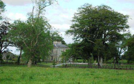
| Portlick Castle | Portlick Three-bay four-storey late medieval tower house, built c.1500 by the Dillon family, with later seven-bay two-storey extension added to the southwest, c.1800, and a two-bay two-storey castellated block added to the southwest corner of this extension, c.1865 (boi). In 1696 granted to Thomas Keightly, a member of King William's privy council in Ireland who sold it to William Palmer of Dublin. About 1703 bought by the Smyth Family, who remained in ownership of Portlick Castle into the twentieth century. Valued at £26 and held by Robert Smyth in fee at the time of Griffith’s Valuation. A fire in 1861 damaged much of the building. Sold by a descendant of the Smyth family in 1955, the castle has been restored in recent times and has been used as a wedding venue. The Westmeath Independent reported the castle’s purchase by a family from California in January 2021. |
|
| Portloman | Portloman, situated on the shore of Lough Owel, is named on the first edition OS map and the 25 inch map. Home of the de Blaquiere family from the mid-18th to the mid-19th centuries. Both Leet (1814) and Lewis (1837) record Portloman as the seat of Lord de Blaquiere. At the time of Griffith’s Valuation John de Blaquiere held the house valued at £18 in fee. When the estate was for sale in June 1866 the mansion house was described as been ‘beautifully situated on the margin of Lough Owel and stands upon a demesne containing about 200 acres Statute measure, handsomely planted, to which is attached a large garden, containing over three acres well stocked, walled in and lined with Brick; Hot Houses, Conservatories etc’. In 1906 the house was in the possession of Colonel David W Stevenson [of Derry]. The buildings had increased in value to £33.10 and were held with 142 acres of untenanted land. This house was destroyed in 1921. | |
| Portnard | Located on the Stafford O'Brien estate and occupied by the Reverend Rickard Lloyd in the mid 19th century, when the buildings were valued at £27. Miss Catherine Lloyd was the last Lloyd occupant. The property was sold 1910-1913. |
|
| Portnason | Portnason was owned by the representatives of Christopher Allingham at the time of Griffith’s Valuation but was unoccupied. The National Inventory of Architectural Heritage suggests it was built in the early 19th century and may have replaced an earlier house, also associated with the Allingham family. It is still extant. |
|
| Portobello | At the time of Griffith's Valuation, John Stafford was leasing a property at Portobello valued at £13 from Lord Lorton's estate. In 1814 it had been the residence of Thomas Stafford who Lewis also recorded as resident there in 1837. | |
| Portroyal | In 1786 Wilson refers to Port Royal as the seat of Mr. Gildea. At the time of Griffith's Valuation, the townland was in the possession of James and Anthony Knox Gildea and the house was valued at £2 10s. The house is not shown on the 25-inch Ordnance Survey map of the 1890s. | |
| Portsalon (Kilmacrenan) | At the time of Griffiths Valuation in the 1850s, the representatives of Baptist J. Barton held this property in fee, when it was valued at £10. Colonel Barton later established the Portsalon Hotel and Portsalon golf club in this locality. In 1906 the buldings were in the ownership of Baptist J. Barton and valued at £105. It is no longer extant. [Grid Reference is for the Portsalon hotel] | |
| Portumna | Reverend Lewis Hawkes was leasing a property at Portumna, valued at £16 from the Ecclesiasical Commissioners at the time of Griffith's Valuation. The Reverend Louis Hawkes of Brierfield died in 1857. A house still exists at the site. | |
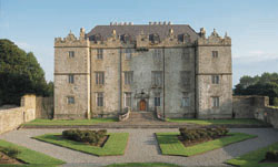
| Portumna Castle | The house we know as Portumna Castle was built in the early seventeenth century by Richard de Burgo or Burke, 4th Earl of Clanricarde. It was used as the de Burgo/Burke family residence for over 200 years until it was badly damaged by fire in 1826 when it was replaced by another house close by. This second house is no longer extant. In 1906 the buildings at Portumna were valued at £40. The original Portumna Castle has been restored and is open to the public. |
|
| Poulboy Mill House | Winifred Daniel was leasing this property from the Osborne estate at the time of Griffith's Valuation, when it was valued at £13 10s. The adjacent mill, valued at £42, was being leased by her to Patrick Corcoran at the same time. By the 1880s the mill is no longer visible. | |
| Pouldrew House | In 1850 Edward Eakers was leasing this property from the Malcolmson estate. The property included part of an extensive mill complex, valued at over £36. It is still extant and occupied. |
|
| Pouldrew Mill | This property is closely connected with Pouldrew House nearby. In 1850 it was leased by Edward Eakers from the Malcolmson estate and valued at £95. The mill was demolished in the twentieth century. | |
| Powellsborough | At the time of Griffith's Valuation, Abraham Powell, was leasing a property at Powellsborough, barony of Leyny, valued at £5 together with almost 400 acres from Edward Powell, In 1906 James J. Powell was the owner of buildings valued at £12 at Powellsborough, barony of Leyny. The Congested Districts Board later acquired over 50 acres of this estate. The house is still extant but derelict. | |
| Powerstown | The residence of George Green in 1814 and in the early 1850s when the buildings were valued at £26+ and held from Mrs Putland and Sir Charles Hulse. This house no longer exists. | |
| Poyntstown | A home of a branch of the Cooke family in the 18th century. In 1786 Wilson refers to "Point's-town" as the seat of William Cooke. He was also the proprietor in 1814. In 1837 Lewis records Poyntstown as the property of Phanuel Cooke "in ruins". The house is marked as in ruins on the first Ordnance Survey map. Fennell Cooke held this townland at the time of Griffith's Valuation. | |
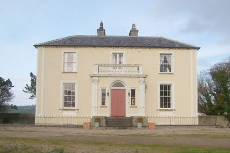
| Prehen | At the time of Griffiths Valuation in the 1850s George Knox held this property in fee when it was valued at £55. The house is still extant and open to visitors. See http://prehenhouse.com/ | |
| Prior Park | Built circa 1780 to the design of William Leeson for James Otway, it became the seat of a branch of the Waller family in 1808. A small drawing of the house is included on the 1824 map. Occupied by W. Waller in 1837 and in the early 1850s, when the house was valued at £37 and held in fee. Members of the Waller family continued to reside here until the 1980s. Still a fine country residence. |

|
| Prohust | Prohust/Prohurst/Proughis was built by Jonathon Bruce, third son of the Reverend Jonathon Bruce of Milltown Castle, and occupied by him in 1837. By the time of Griffith's Valuation the property was held by George and John Evans in fee, the buildings were valued at £37. Hajba writes that the house was occupied by members of the Turner and Rice families in the latter half of the 19th century. This house is still occupied. |
|
| Prospect | The home of Powell in the late 1770s and 1780s, this house was the residence of Sir J. De Burgh Baronet in 1814, of Godfrey Massy in 1837 and of Eyre Lloyd in the early 1850s. Eyre Lloyd held the property from Eyre Powell and it was valued at £46. This mansion house valued at £43 was occupied by Anne G. Crosby in 1906. It is now a ruin. |

|
| Prospect | Richard Ouseley (1733-1804) rebuilt Prospect House and let it to Captain Charles O'Connor. The remains of outbuildings are still visible. |
|
| Prospect | Prospect Lodge is recorded as the residence of T. Burke in 1814. At the time of Griffith's Valuation it was leased by Thomas Courtney to John Lopdell. It is still extant and occupied. |
|
| Prospect | Taylor and Skinner record General Gabbet as the proprietor in the 1770s. This house was occupied by J. S. Handcock in 1837 and by Maurice Studdert in the early 1850s and held from Sir John Carden. The buildings were valued at £15.10 shillings. In 1840 it was described in the Ordnance Survey Name Books as "a good dwelling house with ornamental grounds, the residence of Thomas Purvis". Later leased to the Woodwards and still in use as a residence. |
|
| Prospect (Killarney) | In 1786 Wilson that a house named Prospect, one mile from Killarney, was the seat of Mr. Supple. The Ordnance Survey Name Books mention Prospect House as the residence of Thomas Browne in the 1830s. It seems to have become ruinous after this as only a gate lodge is mentioned in Griffith's Valuation and Prospect is now shown on the 25-inch Ordnance Survey map of the 1890s. | |
| Prospect (Kiltartan) | Occupied by A. Nolan in 1814. Lewis records Prospect as the seat of Nolan in 1837. By the time of Griffith's Valuation it appears to have been part of the estate of the representatives of Vicesimus Knox and leased to William Mulville. The house is still extant and occupied. |
|
| Prospect (Meelick) | In 1856 Joseph Cowan was leasing a property at Prospect, in the parish of Meelick, barony of Longford, from Francis Usher. In 1837 Lewis recorded Prospect as the seat of C.A. O'Malley. Slater refers to it as the seat of John Smith in 1846. In 1906 Prospect was the property of Ernest Kenny and valued at £12. In 1778 and 1786, this property was the residence of the French family. Prospect House is still extant and occupied. |
|
| Prospect Hill | At the time of Griffith's Valuation the house and buildings at Prospect Hill were in the ownership of Lord Wallscourt's trustees and were valued at £21. Earlier, the Ordnance Survey Field Name Books mention Mr. Dawson of Prospect, as the agent to the Wallscourt estate. There is still a house at the site but it is not the original one. |
|
| Prospect Hill (Dunmanway) | Elizabeth Bryan was leasing this property from the Cox estate in 1851 when it was valued at £22. There is still an occupied house at the site. | |
| Prospect House | Home of the Buchanan family in the latter part of the 19th century. Slater refers to it as the seat of Col. Henry J. Buchanan in 1894. Still extant and very well maintained. |
|
| Prospect House | John Donnellan was leasing this property from the Kirwan estate at the time of Griffith's Valuation when it was valued at £4. It is labelled Prospect House on the 25-inch Ordnance Map of the 1890s. Occupied until 1977, now used for storage. |
|
| Prospect House | Occupied by Thomas McNamara at the time of Griffith's Valuation, held from Henry Watson and valued at £22. Described in the sale rental of 1856 as a capital house and office on which over £1,000 had been spent on improvements. The original lease dated 1796 was from Thomas Maunsell to Philip Smith for the lives of members of the Watson family. Henry Watson was the tenant in 1856 and Sir Christopher Arbuthnot Maratt in 1877. | |
| Prospect House | The National Inventory of Architectural Heritage dates the building of this house to about 1770. Slater’s Directory records John Thompson of Prospect House in 1846. At the time of Griffith’s Valuation this house was vacant but held by Mary A. Sanderson of Cloverhill. This house is now a ruin. | |
| Prospect House | The National Inventory of Architectural Heritage dates the building of this house to about 1770. Slater’s Directory records John Thompson of Prospect House in 1846. At the time of Griffith’s Valuation this house was vacant but held by Mary A. Sanderson of Cloverhill. This house is now a ruin. | |
| Prospect House (Cavan) | The National Inventory of Architectural Heritage dates the building of this house to about 1770. Slater’s Directory records John Thompson of Prospect House in 1846. At the time of Griffith’s Valuation this house was vacant but held by Mary A. Sanderson of Cloverhill. This house is now a ruin. |
|
| Prospect House (Gaultiere) | In 1848 James Merritt was leasing this property from the Grant estate when it was valued at £21. The house is still extant and occupied. |
|
| Prospect House (Gaultiere) | Westerna Lewis was leasing this property from the representatives of M.Hayes at the time of Griffith's Valuation, when it was valued at £29 15s. A small building is shown on the 1st edition Ordnance Survey map but a more substantial one, labelled Prospect House, appears on the 25-inch map of the 1890s. A house is still extant at the site. | |
| Prospect Lodge | Originally a Royal Irish Constabulary barracks, it became the residence of the Bellingham's agent Mr Smithwick in the 1870s. This house is no longer extant. | |
| Prospect Lodge (Waterford) | Henry Bolton was leasing this property to Michael Ardagh at the time of Griffith's Valuation when it was valued at £22. It is still extant though perhaps not currently in use. |
|
| Prospect Villa | Thomas Burke was leasing Prospect Villa from Mary and Catherine Rogers at the time of Griffith's Valuation, when it was valued at £60. Lewis refers to it as the seat of Lt.Col. Burke in 1837. The house was included in the sale of the Rogers estate in the Landed Estates Court in February 1862. In 1943 the Irish Tourist Association Survey noted Prospect Villa as the residence of G. Hosford and outlined Burke's association with the house mentioning that he kept a racing stable there. The house is no longer extant and a factory has been constructed in this area. | |
| Prospect Villa (Inishannon) | At the time of Griffith's Valuation, Richard Denehy was leasing this property from the Erasmus Smith trustees when it was valued at £25. It was burnt in June 1921 during the War of Independence when it was the residence of Michael Dennehy, JP. A house still exists at the site. | |
| Prospect Villa (Kinsale) | Prospect Villa was being leased by John G. Daunt to Frances Falloon at the time of Griffith's Valuation, when it was valued at £12. The property now known as Prospect Villa, probably built in the 1870s, was offered for sale in 2009. |
|
| Prospect Villa (Kinsalebeg) | Prospect Villa seems to have been built in the later nineteenth century, close by an earlier house known as Mayfield. A house at Prospect Hall is described by Smith as "a handsome seat with good improvements made by the late Stephen Bernard" In 1786 Wilson refers to "Prospect Hall" as the seat of Mr. "Barnet". There is still an extant building at the site. |
|
| Purrauns | Home of a branch of the Bell family of county Mayo and occupied by the Lynches in the mid 19th century. At the time of Griffith's Valuation it was occupied by Patrick King leasing from James Lynch when the buildings were valued at £5. Buildings are still extant at the site. |
|
| Pyrmont House | Wilson refers to "Fyrmont" as the seat of George Leake in 1786. In 1837 Lewis recorded this house as the seat of W. Sandes. At the time of Griffith's Valuation, the representatives of Lord Hallyburton's estate were leasing this property to William Sandes, whom Bary describes as the most "fair-minded" of the Sandes family and a noted horseman. The house was valued at £13 10s at the time. Prymount was included in the sale of the Gun Mahony estate in 1856 when William Sandes was recorded as the tenant from year to year. It later passed to the Sandes of Swallowglen and was subsequently demolished. | |
| Quainsborough/Quansbury Lodge/Stowlin | Originally a Daly house. In 1783 Taylor and Skinner and Wilson, in 1786, record Queensborough as a seat of the Earl of Louth. Slater refers to Quansborough Lodges as the seat of William B. Burke in 1846. Mentioned in the sale notice for portion of the St. George estate in November 1853. John P Watson was the occupier of a house valued at £13 in the townland of Stowlin, parish of Kilquain, barony of Longford, in 1856. In 1906 this house was owned by Kate Watson and was valued at £33. Buildings are still extant at site though may have been modernised. The Clonbrock Estate Papers, Collection List 54 in the National Library contain early 19th century rentals of the Quansbury estate. In many documents the name of this house is spelt Quansbury but on the Ordnance Survey maps it is spelt Quainsborough. |
|
| Quarryfield | McTernan notes that Robert Howes of Bunninadden and Quarryfield married Jane Irwin of Mount Irwin in 1754. Subsequently the then house at Quarryfield alternated between Howes and Irwins. In the 1840s the property was purchased by Col.Perceval of Templehouse and later in the nineteenth century by the Coopers of Markree, by whom the present house was built in 1887. The house had a number of owners since and is still extant and occupied. |
|
| Quarrymount | Built in the 1830s, Quarrymount [also known as Kilcloony] was the home of the Bodkin family in the latter half of the 19th century and is reputed to have replaced an early home in the nearby townland of Ardnagall. The house was leased to Edward O'Kelly in 1881 for 31 years. By the early 20th century it was in the hands of the Congested Districts' Board and passed onto the Land Commission who sold the house and 220 acres to the Gordon family. In 1971 Henry Gordon sold the house and remaining 20 acres. The house has been extensively renovated in the early 21st century by the Costellos. |
|
| Quartertown House | A Dillon residence in the mid 18th century, passed by marriage to the Crokers. Wilson, writing in 1786, refers to it as the seat of Mr. Dillon. The Crokers also owned the mills nearby. Occupied by John D. Croker at the time of Griffith's Valuation and held by him in fee. The buildings were valued at £40. Later bought by the Webb family. In 1942 the Irish Tourist Association Survey mentioned that it was then let to the Nazareth Sisters. It is now in ruins. | |
| Queensfort House | This house no longer exists. It was the home of a branch of the Leonard family in the 19th century. At the time of Griffith's Valuation it was held in fee by Stephen J. Leonard and valued at £16. |
|
| Queensfort Lodge | An old building still appears to be extant behind a large modern house. |
|
| Querrin | Originally built in the Dutch style by the Van Hogart family who intermarried with the Hickmans of nearby Ballykett. Later the home of the Borough family, William Borough was resident in 1814 and it was later occupied by their descendants, the Counihans. Dr John F. Counihan was in possession of Querrin in 1906. This house close to the shore of the Shannon is still a family home, old walls are still evident and the house has been modernised. |
|
| Querrin Lodge | Querrin Lodge was enlarged after the publication of the 1st edition Ordnance Survey Map and Griffith's Valuation. Borough family history indicates that it became the property of Randal Borough of Cappagh Lodge in the early 1850s. It is labelled Querrin Lodge on the 25-inch edition map of the 1890s. The building is still extant but derelict. | |
| Quignalecka | At the time of Griffith's Valuation Rev. James Lindsay was leasing a property valued at £5 at Quignalecka, to Capt. William Wright. Since 1898 this townland has been part of county Mayo. | |
| Quignamanger | Charles Craig was leasing a property valued at £6 at Quigamanger, barony of Tireragh, from Edward Howley at the time of Griffith's Valuation. Since 1898 this townland has been located in county Mayo. Modern housing exists in this location now. | |
| Quignashee | Edward Howley occupied a property valued at £5 at Quignashee, barony of Tireragh, as well as 300 acres, at the time of Griffith's Valuation. Since 1898 this townland has been located in county Mayo. A building remains at the site. | |
| Quilca House | Quilca was associated with the Sheridan family. The Reverend Thomas Sheridan was a friend of Dean Swift. In 1725 the Dean wrote some of ‘Gulliver’s Travels’ while staying with the Sheridans at Quilca. In 1814 Robert Doughty was resident and the Reverend Luke O’Reilly in the 1830s. No occupant is given in Griffith’s Valuation when the building was described as a herd’s house and was valued at £5. Joseph Le Fanu was the immediate lessor. A mid-20th century house now occupies the site. | |
| Quilty House or Salus House | Summer residence of the Crowe family, this house is marked on the first Ordnance Survey map of 1842. It was valued at £25 at the time of Griffith's Valuation and recorded as a mansion house in 1906. It is labelled Salus House on subsequent Ordnance Survey maps but is no longer extant. | |
| Quinsborough | The original lease of this property was dated 26 September 1712 from the Earl of Thomond to Henry Widenham. The house was built in 1767 by George Quin, son of Valentine Quin and his wife Mary Widenham. Wilson refers to it as the seat of Mr. Quin in 1786. It was the residence of his grandson, Lord George Quin, in 1814. In 1837 Lewis records Quinsborough as the home of Martin Honan, who was elected Lord Mayor of Limerick in 1841. By the mid 19th century Quinsborough was the home of Anne Maria Honan. It was valued at £42 and held in fee. Advertised for sale with 187 acres in November 1868 by Martin Honan Bourke. Modernized in the early 20th century, some of the house contents were auctioned in the [1940s] on the instructions of S.J.K. Roycroft, a director of the Limerick Steamship Company. The house was the residence of the McGoverns in the 1980s. It is still extant. |

|
| Quinville House | An 18th century house, Lewis writes that it was rebuilt in the early 19th century in the Elizabethean style, home of the Singleton family. In 1906 Quinville was in the possession of James Butler Ievers. The property was bought by the McCausland family of Drenagh, county Derry in the 20th century. In the late 1990s the house was undergoing a major restoration by the owners, the Houlihan family. in 2012 it was offered for sale. |

|
| Racecourse Hall | Lewis records Avary Jordan as the proprietor of Race-Course Lodge in 1837. The house was valued at £35 in the mid 19th century, occupied by Avary Jordan and held from the Cashel Commissioners. Mrs Jordan of Racecourse owned 3 acres in the 1870s. This house, located just south of the town of Cashel, still survives as a fine country residence. |
|
| Racket Hall | Racket Hall was occupied by Patten Smith in 1814. Lewis writes that Messrs Birch and Co had a large brewery at Racket Hall and Mrs Mary Birch was the occupier of the house at the time of Griffith's Valuation. She held the property valued at £16+ from George Birch and Co. The brewery was valued at £18. The house is now incorporated in a hotel complex see http://www.rackethallhotel.com/welcome.html | |
| Raconnell | Raconnell belonged to the Owen family in the 18th century. The will of Nicholas Owen of Raconnell is dated 1 May 1759. Possession of this townland passed to the Lucas and Cole families through marriage. It is named on the 1st edition 6 inch Ordnance Survey map (1836) with a substantial yard and walled garden to the rear. Occupied by Colonel R. Lucas in the 1830s. Edward William Lucas lived here at the time of Griffith’s Valuation when the buildings were valued at £24. By the mid-1870s Thomas Coote was occupying Raconnell. Raconnell House is still extant but unoccupied. |

|
| Rafarn House | At the time of Griffith's Valuation, Rafarn House was leased from the Clanricarde estate by Thomas Tully and was valued at £17 and was accompanied by over 400 acres. In 1814 it was recorded as the residence of Joseph Tully. It is still extant. |

|
| Raferagh | A complex of buildings which included a house, corn mill, scotch mill and kiln were valued at £12 in the mid-19th century. Occupied by James Johnston they were located on the Shirley estate. This group of buildings is now much reduced in size. | |
| Raffeen Cottage | Robert White was leasing this property to Sarah Phillips at the time of Griffith's Valuation when it was valued at £12 5s. It appears on the 25-inch Ordnance Survey map as Raffeen Cottages, indicating the presence of more than one dwelling. The buildings are still extant. | |
| Raffeen House | Robert Hedges White held this property in fee at the time of Griffith's Valuation, when it was valued at £42. It was the home of his wife's family, Charlotte Mary Dorman. In 1837 Lewis referred to it as the seat of T. Dorman. The property is still extant. |

|
| Raffeen House [Lower] | William Drinan was leasing this property from the White estate at the time of Griffith's Valuation, when it was valued at £13 10s. The site is now occupied by industrial premises. | |
| Raford | The National Inventory of Architectural Heritage suggests that Raford House was built c.1760. Wilson refers to it as the seat of Captain Daly in 1786. It was being leased by Denis Bodkin from Harriett Daly at the time of Griffith's Valuation, when it was valued at £40. John Archer Daly was the owner of Raford House in 1906 when it was also valued at £40. Raford is still extant and occupied. Modern development has taken place on part of the demesne lands. |
|
| Raghly Lodge | Raghly Lodge was held in fee by Charles Gore Jones at the time of Griffith's Valuation, when it was valued at £10 10s. In 1894 it was also noted as his residence by Slater. McTernan notes that it was remodelled in the early twentieth century and raised to two storeys. It remained in the Jones family until c.1912. It is still extant and occupied. |