Browse Houses
Search Results: Returned 5926 records. Displaying results 4501 – 4600
| House name | Description | |
|---|---|---|
| Oakpark (Kilmacrenan) | In the 1850s William Wray was occupying Oakpark when it was valued at £21. The National Inventory of Architectural Heritage suggests it was built at the end of the 18th or beginning of the 19th centuries. It may have been built by the Wray family after they left Castle Wray. Oakpark is still extant and occupied. |
|
| Oakpark or Collis-Sandes House | Maurice Sandes was in possession of this property at the time of Griffith's Valuation, when it was valued at £60. It is labelled as Oakpark on the 1st edition Ordnance Survey Map. In 1837 Lewis recorded Oakpark as the seat of John Bateman. Bary writes that, Killeen, the original house at this site, was a late seventeenth century house. It was followed by Oakpark, built by John Bateman in the 1820s. This is the house mentioned by Wilson in 1786 as the seat of Rowland Bateman. Maurice Sandes purchased the estate in the late 1840s and built the later Oakpark House c.1857. In 1906 this house was owned by Falkiner Sandes and valued at £112. The house was sold in 1922 and is now used as offices. |
|
| Oakport | Oakport was the home of the Reverend William French, fourth son of John French of French Park, in the early 18th century. At the time of Griffith's Valuation, Oakport House, the property of Thomas William Goff, is recorded as "unoccupied". A house is still extant at the site. | |
| Oatfield | Oatfield House, owned by John Longworth , was vacant at the time of Griffith's Valuation. Earlier, in 1837, Lewis had recorded it as the seat of Major Lynch even though this house had been in the possession of the Longworth family since at least 1814. The Ordnance Survey Field name books also record it as the residence of Major Lynch. In 1783 Taylor & Skinner and in 1786,Wilson, both recorded Oatfield as a property of the Brabazon family. By 1906 it was the property of Edward Longworth. The original house is not extant at the site now. |
|
| Oatlands | Built in the 1840s or 1850s and located on the side of the road, Oatlands was the residence of William Rogers at the time of Griffith’s Valuation. He held the property in fee and its rateable valuation was £11. In 1901 Margaret Rogers, a widow, lived at Oatlands with her daughter’s family, the Gaffneys. in 1906, Margaret J. Gaffney was recorded as the occupier, when the building had a rateable valuation of £14. Home of the O’Reilly family in 1911and still extant. | |
| Oatlands | In 1837, Lewis refers to Oatlands as "the handsome mansion of Captain Knolles" and that their original house at Killeigh was in ruins. At the time of Griffith's Valuation the property was held in fee by Thomas Walton Knowles, when it was valued at £35. There is still an extant house at the site. | |
| Oatlands House | The residence of the O'Dowds of Bunnyconnellan until the sale of their estate in 1854 when it was bought by Charles Downing and leased to Henry McLoghry. At the time of Griffith's Valuation Downing held it in fee when it was valued at £10. It is labelled Bunnyconnellan Cottage on the 1st edition Ordnance Survey Map but as Oatlands House on the 25-inch edition of the 1890s. This is the name by which it is still known. The Irish Tourist Association file refers to Oaklands House owned by Mr McAndrew in which some of the old O'Dowd house was probably incorporated. The house has been restored and in 2015 was offered for sale. | |
| Odell Lodge/Melrose House | Leased by Rev. Thomas Thurtle from the O'Dell estate in 1851 when it was valued at £18 10s. The National Inventory of Architectural Heritage indicates it was later known as Melrose House. In 1942 the ITA survey noted the property as the Melrose Hotel, formerly Odell Lodge. The survey states that it was built by the Odell family as a summer residence. It is still extant and occupied. |
|
| Odell Ville | This house was occupied by John Odell in the early 1850s and held by him in fee. It was valued at almost £14. The house was the residence of William Odell in the 1870s. Home of the Morony and Lloyd families in the late 19th and 20th centuries. Occupied by Wilfrid H. Wilkinson in 1906. It was advertised for sale in February 2009. |

|
| Oghil | Oghil house is recorded in the OS Name Books as being built in the 1740s, though McTernan states that the existing house dates from the late 1830s. At both the time of Griffith's Valuation and in 1906 it was the property of Robert W. Armstrong and was valued at £17. It later served as the parochial house but is now a family home again. See http://www.westsligo.com/culleens/historyoghillhse.htm for more details. |
|
| Oghil | At the time of Griffith's Valuation, Allan Pollok held a property at Oghil More townland, parish of Clonfert, on which a house was in progress, together with a mill and other buildings. The property stood on 368 acres. The mill chimney was demolished during the later twentieth century but many of the other buildings remain. | |
| Oghilly | At the time of Griffith's Valuation, Michael Page was leasing a house at Oghilly, parish of Ballynakill, barony of Leitrim, county Galway from the Clanricarde estate. It was valued at £9. The National Inventory of Architectural Heritage suggests that this house dates from the 1770s. It is still extant and occupied. |

|
| Old Abbey | The home of the Greene family for most of the 18th century. In 1786 Wilson refers to "Abbey" as the seat of Mr. Greene. Subsequent tenants were the Hodges and the Morgans. The Ordnance Field Name Books state that part of the building was very ancient and that a new front had been built in 1805. George Morgan was resident in 1814, William Morgan in 1837 and in the early 1850s, when he held the property from the Earl of Cork. Old Abbey passed to Willliam's daughter, Mrs Wardell, and stayed in the possession of the Wardell family into the 20th century. It is no longer extant. |
|
| Old Castle | At the time of Griffith's Valuation, Robert Rogers & others were leasing a property at Kingsfort, barony of Tirerrill, to John Gardiner. It was valued at £10. Earlier, in 1786, Wilson refers to Kingsfort as the seat of Rev. Mr. Dodd. McTernan states that this property was originally part of the Mitchell estate and later became a police barracks. It was demolished in the 1990s. | |
| Old Castle (Tracton) | Achilles Daunt was leasing this property to Bartholomew Coveney at the time of Griffith's Valuation, when it was valued at £10. A house and extensive farm now exist at the site. | |
| Old Court | Old Court located on the northern outskirts of Athlone town was built circa 1840 (O’Brien) and incorporated an earlier house. The building on the site on the first edition OS map is named Springpark House. The Potts were settled here from the 18th century. P Cusack occupied Spring Park in 1837 and the house valued at £26 was held by William Potts in fee at the time of Griffith’s Valuation (publ. 1854). In the early 20th century the house was occupied by the Magan family and William Morgan Tilson Magan spent his childhood years here. This house was demolished in the 1980s. | |
| Old Court (Doneraile) | Originally a Watkins house, the property was leased to Jonas Stawell in 1813. The Stawells built a new house circa 1814. The Watkins sale rental of June 1853 includes a lithograph of the house and floor plans. In the early 1850s George C. Stawell held the house, valued at £40, from Edmund Nagle. Sold in the early 1850s to the Morroghs of Glanmire House. In the 1940s the Irish Tourist Association Survey noted that this property had also been associated with Alexander Roche, the brother of Lord Fermoy. At the time of the survey the house was occupied by a Miss Creagh and a Miss Shannon. It is now a ruin. |

|
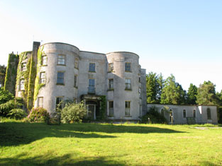
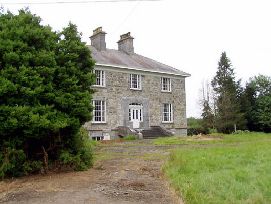
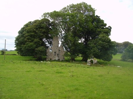
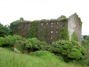
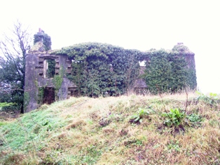
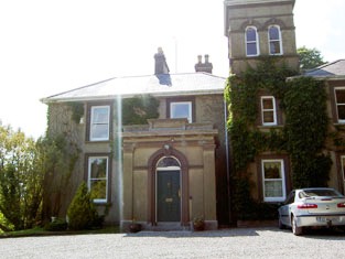
| Old Court [Lixnaw House] | The Irish Tourist Association Survey refers to the "once magnificent mansion" of the Fitzmaurices, Earls of Kerry. By the 1940s only a few walls remained "supporting a henhouse and some turnip and potato pits". The survey also noted the survival of a summer house, a high circular mausoleum and a "hermitage". Bary notes that the property was home to the family for up to 500 years but fell into ruin in the later eighteenth century. It is labelled "Lixnaw House (in ruins)" on the 1st edtion Ordnance Survey map but as "Old Court" on the later 25-inch edition of the 1890s. Some ivy-covered ruins remain at the site. |
![Photo of Old Court [Lixnaw House]](https://landedestates.ie/storage/img/orig/2854.jpg)
|
| Old Dromore | Smith refers to the "pleasant seat" of Sir Matthew Deane, "lately rebuilt, with an elegant front of hewn stone". A larger house built in the early 1780s was dismantled almost as soon as it was built by Sir Robert Deane, lst Baron Muskerry. Hajba writes that Jeremiah and Richard Gifford Campion occupied Dromore Old in the last decade of the 18th century. A house valued at £23 in the mid 19th century was the home of the Williamson family located on the Purcell estate. Occupied by U[sher] Williamson in 1814, Reverend Benjamin Williamson in 1837 and in the early 1850s. In 1894 Slater refers to it as the residence of Mrs. Williamson. In the latter half of the 20th century the home of the Hegartys. A house is still extant at Dromore. | |
| Old Dromore House | The representatives of Rev. D. Mahony were leasing a house valued at £25 to James McClure at the time of Griffith’s Valuation. The McClures were the agents for the Mahony estate for many years. It is labelled "Dromore Old" on the 1st edition Ordnance Survey map and as "Old Dromore House" on the later 25-inch edition of the 1890s. Bary states that it was the original Mahony house before the building of Dromore Castle. It is not extant now. | |
| Old Eden House | Old Eden House appears on the 1st edition Ordnance Survey map though is not labelled. It was leased by Galbrait Hamilton from the Conyngham estate at the time of Griffiths Valuation in the 1850s when it was valued at £8. The 25-inch map shows both Old Eden House (at that location) and Eden House, a short distance away. Some buildings at Old Eden House are in use as tourist accommodation. | |
| Old Fort | A house occupied by Henry Good at the time of Griffith's Valuation, held from Samuel Penrose and valued at £18.10 shillings. | |
| Old Head Lodge/Falduff Lodge | A house built in Falduff townland after the 1st Ordnance Survey map and labelled Old Head Lodge on the 25-inch map of the 1890s. In 1894 Slater refers to Falduff Lodge as the seat of Patrick O'Dowd. It is still extant. | |
| Old Park House (Templemartin) | Leased by Benjamin Hosford from the Devonshire estate at the time of Griffith's Valuation, when it was valued at £13. Lewis refers to Old Park as the seat of H.Gillman in 1837. A house still exists at the site. | |
| Old Rock | At the time of Griffith's Valuation John Trumble was leasing a property valued at £4 at Old Rock, barony of Corran, from Johnston Parke. McTernan states that John Trumble eventually disposed of his interest in this property and settled in Manchester. The original house is no longer extant. | |
| Old Town | S. Crooke was residing at Old Town in 1837 and Simon D. Crooke in the early 1850s when the house was valued at £14.10 shillings and held from William Furlong. It is no longer extant. | |
| Oldcastle | Built by the McJordans of Ballylahan in the late 18th century. Slater refers to it as the seat of John Bolingbroke in 1846. There are modern buildings at the site now. |
|
| Oldcourt | John Brereton of Oldcourt was the second son of John Brereton of Rathurles and his wife, Margaret Watson. He had a son,John, born 1817. The Ordnance Survey Name Books refer to it as his property in 1840 but mention that it was "a commodious house" occupied by his land steward. John Brereton held Oldcourt in fee at the time of Griffith's Valuation when the house was valued at £12. A building is still extant at this site. | |
| Oldcourt | Oldcourt was the seat of the Goold family baronets until 1852 when it was bought by Alexander Glasgow. The sale rental of March 1852 includes a lithograph of Oldcourt. Griffith's Valuation records Glasgow holding the property in fee and the buildings were valued at £68. The Glasgows leased the house until it was bought in the early 20th century by Henry O'Shea although Alexander J. Glasgow is recorded as the occupier in 1906 when it was valued at £51. Henry O'Shea sold it to the Brothers of Charity in 1934 whose services used it as a Special Needs school. It is still extant. |
|
| Oldcourt House | Martin Jennings was leasing Old Court from the Becher estate at the time of Griffith's Valuation when it was valued at 15 15s. Referred to by Leet as the seat of Michael Galway in 1814. It is still extant. |

|
| Oldgrange House | Nicholas O'Neill Power was leasing this property to James Quinn at the time of Griffith's Valuation, when it was valued at £9. Buildings are still extant at the site. | |
| Oldhead House/Oldhead Lodge | Part of an estate bought by John Browne 3rd Earl of Altamont in 1794 this house, situated very close to the seashore, was let to various persons during the 19th century including Isidore Blake, Reverend Francis Ruttledge. At the tie of Griffith's Valuation it was occupied by Campbell Sawers and valued at £8. It is labelled Oldhead Lodge on the 1st edition Ordnance Survey map but as Oldhead House on the later 25-inch edition. In 1936 the house was sold to John Gardner of Lackafinna, Cong, county Mayo. It later became a hotel and is now the centre of a holiday village. |
|
| Oldtown | The home of the Bennett family in the 19th century, occupied by Theophilus Bennett in 1814 and by John Bennett in the early 1850s. The property was held from the Cardens and the buildings were valued at £19+ in the mid 19th century. This house was demolished by the early 20th century. | |
| Oldtown | Oldtown is named on the first edition OS map and the 25 inch map. A two-storey, three-bay house built by the Banon family. Occupied by J Banon in 1837 and at the time of Griffith’s Valuation (publ. 1854) by Thomas Bannon who held the property valued at £13 from James Fallon. Oldtown was for sale in the Encumbered Estates Court in 1851. The house, described as a comfortable two-story house, fit for the residence of a gentleman, was occupied by Anne, Frances and Maria Banon, (Sale Rental 19 Dec 1851) and was bought by James Fallon, a wine and spirit merchant of Dublin. James Fallon of Oldtown is recorded among the 1876 landowners of the county. The Fallon family were still resident at the beginning of the 20th century. | |
| Oldtown | A single storey house until the early 20th century when a second storey was added to part of the house. Occupied by the Bourkes from the 18th century until the 1920s and then by the Curran family. Restored by the present owner in the late 1990s. |
|
| Oldtown House (Fermoy) | William Creagh of Oldtown married Sarah Nagle of Annakissy in the 1770s. The Creaghs were succeeded at Oldtown by the Evans family. Rear Admiral Henry Evans was the occupier in 1837. Oldtown was the residence of Nicholas Evans in the early 1850s. Valued at £29 it was held from Pierce Nagle. Later occupied by the Campion and Roberts families. Oldtown is still extant. |
|
| Oldtown House (Longford) | James and George Sydserffe were leasing this property from the Gregg estate at the time of Griffiths Valuation in the early 1850s, when it was valued at £25. The original Valuation Office books from 1839 had assigned it a valuation of £14. In 1837 Lewis had recorded “Old Bawn” as the seat of Thornton Gregg. The Ordnance Survey Name Books noted that 'it had a large garden and extensive out offices'. Oldtown House is still extant and in use. |
|
| Oory/Coarsefield | It is probable that the townland of Coarsefield was part of Oory in the 18th century and that Oory was divided into two townlands at the time of the first Ordnance Survey. The remains of an old house are still visible at Coarsefield, close to the present house, and it is believed that this was Oory House, home of the Bourkes and later owned by the Nettervilles. In 1814 "Course-field" belonged to James Netterville. The sales rental of the Gray estate of Coarsefield in 1861 refers to one wall remaining of the old Netterville house. |
|
| Oran (Ballymoe) | In 1778 the residence of R. Malone esquire is recorded at Oran. Wilson also refers to this property as the seat of Lord Sunderlin [Richard Malone]. This residence may have been in the townland of Cartron, | |
| Oran Castle | In 1786 Wilson mentions Oranmore as the seat of Denis Blake. In 1814 and again in 1837 Oranmore Castle is recorded as the seat of Walter Blake. At the time of Griffith's Valuation he was leasing a property, valued at £10, in Oranmore townland, to Martin Grady. Pádraig Lane writes that Walter Blake sold Oran Castle to James Dillon Meldon. The castle was refurbished by the King family in the twentieth century. |
|
| Oran Vale | Located directly north of Ballynacarrigy, Oran Vale is named on the first edition OS map and was occupied by J Irwin in 1837. Valued at £15 it was unoccupied at the time of Griffith’s Valuation (publ. 1854) while the immediate lessor was Thomas William West who held the property from Alicia O’Connor Malone. The house is not named on the 25 inch map and is now a ruin. | |
| Oranbeg | At the time of Griffith's Valuation the property at Oranbeg was leased by the Fitzgerald Vesey estate to George Hill and valued at £8. It is labelled Vesey Lodge on the 25-inch Ordnance Survey map of the 1890s. It is no longer extant. | |
| Orchardstown | The home of the Hamerton family in the 19th century, occupied by John Hamerton in 1814. Mathew Hamerton was the occupier in the early 1850s holding the house from Major William M. Hamerton. The buildings were valued at £18+. | |
| Oriel House | Built in the first decade of the 19th century by the Board of Ordnance. The house was occupied by Charles Wilkes, the superintendant of the gunpowder mills until purchased by the Tobins of Liverpool in the mid 1830s. Mrs Tobin was a painter and their residence became known as Oriel House under Tobin ownership. The house has been a hotel since 1983. |

|
| Orme's Lodge | Robert Orme was the owner of several properties in the village of Enniscrone, Carrowhubbuck South, barony of Tireragh, at the time of Griffith's Valuation. These properties had valuations of between £12 and £20. McTernan notes that one of these was Orme's Lodge which remained in the family until the 1930s. It subsequently became a hotel and was demolished in the 1990s to make way for new house building. |
|
| Ormond Cottage | Ormond Cottage was the residence of Samuel Waller in 1837 and is also noted in the Ordnance Survey Name Books which describe it as "a neat cottage". In the early 1850s he held it in fee and the buildings were valued at £15.10 shillings. It was included in the sale of 1856 sale. A building is still located at this site. | |
| Ormond View | The representatives of Redmond Dolphin were leasing a property at Ballycrossaun, barony of Longford, to John D. Lemon at the time of Griffith's Valuation when it was valued at £12. Slater notes this property as the seat of Joseph Lemon in 1846. Hogan states that this house was formerly known as Waterview. Ormond View is still extant and occupied. |
|
| Ouvane Cottage | Lieutenant Hewson, Royal Navy resided at Ouvane in 1837 and Maurice Hewson lived there in the 1850s when the buildings valued at £14 were held from Lord Monteagle. This house is no longer extant. | |
| Overton | Overton House was held by Miss McCarthy at the time of Griffith's Valuation, when it was valued at £32. Lewis notes it as the residence of Col. Clerke in 1837. it is a house principally associated with the Allman family. The adjacent cotton mill is described as "disused" on the 25-inch Ordnance Survey map of the 1890s. Both buildings are now in ruins. |
|
| Owendoon | There was a house called Cottage in this townland marked on the first edition six inch Ordnance Survey map (publ. 1837). Owendoon was built nearby in the late 1850s by George Henry L’Estrange. By the early 20th century Edward Langford Hunt was resident. He died in 1907 and W.M. Hunt of Owendoon in 1925. Owendoon now functions as the Jampa Ling Buddish Centre. |
|
| Owenmore or Millbrook | Ordnance Survey Field Name Books record a 'neat cottage' in the townland of Correens, built in 1796 and called Millbrook. Irish Tourist Association File records Owenmore as the residence of the Misses Knox in 1942, erected about 1830 by the Orme family. The house belonged to the McCausland family in the latter part of the 20th century. Now owned by Gerry O'Mara. |
|
| Ower | In 1786, Wilson refers to "Aur" as the seat of Mr. Burke. The Ordnance Survey Name Books record John Burke as the owner in the 1830s. At the time of Griffith's Valuation, Joseph Burke held this property in fee when it was valued at £13. It was leased to Colonel Beddington in the 1920s and is now a ruin. |
|
| Oxfield | At the time of Griffith's Valuation, Oxfield House was the caretaker's residence for the plantation of over 150 acres owned by the Gore Booth estate at Cullaghmore, barony of Carbury. | |
| Oxford | The home of members of the Joyce family in the late 18th and early 19th centuries, later held by the Tuohys in fee. In 1786 Wilson refers to it as the seat of "Mr. Joice". The house and over 740 acres held in fee by Martin Joyes were advertised for sale in the ''The Telegraph'' [Connaught Telegraph] of 13 July 1831. The original house is now a ruin. |
|
| Oyster Hall | Edward Denny was leasing this property to William J. Neligan at the time of Griffith's Valuation, when it was valued at £18 Lewis refers to it as the seat of Barry Collins while Oyster Lodge was the residence of Mr.Neligan in 1837. IIn the 1830s, the Ordnance Survey Field Name Books mention Oyster Hall as the seat of Daniel Supple but originally built by George Rowan in 1804. In 1814, Leet refers to Oyster Hall as the residence of George Rowan. Bary states that Oyster Hall was orginally built by the Rowans but was associated with the Neligans by the middle of the nineteenth century. It is no longer extant. | |
| Ozierbank House | Mrs. Hannah Palmer was leasing this property from the Leper Hospital Trustees in 1848, when it was valued at £16 10s. It is labelled as Ozierbank House on the 25-inch Ordnance Survey map of the 1890s. The building is no longer extant. | |
| Palace Anne | Wilson, writing in 1786, refers to Palace Anne as the seat of Mr. Bernard. Both Leet in 1814 and Lewis in 1837 note Palace Anne as the residence of Arthur B. Bernard. It was held in fee by him in 1851 when it was valued at £30. Lewis describes it as " a stately mansion, beautifully situated". Bence Jones states that it was named in honour of Anne LePoer, wife of Arthur Bernard, who built the house in 1714. The house became dilapidated after the sale in the mid-nineteenth century and much of it has been demolished though one wing still survives. In 1944 the Irish Tourist Association Survey reported that it was then in a possession of Mr Warner who had refurbished this wing as a dwelling. The Survey provides a detailed description of the remainder of the property. |

|
| Palace Anne Mills | A substantial milling complex and house, leased to William Norwood by Arthur B. Bernard in 1851, when it was valued at £34. Lewis referred to the property as "an extensive flour mills" in1837. The property has been converted into apartments in the last decade. |

|
| Pallacetown House | Pallacetown House was held in fee by Samuel P. Townsend at the time of Griffith's Valuation, when it was valued at £14. On the 25-inch map, published in the 1890s, it is labelled Pallastown. In the 1940s the Irish Tourist Association Survey stated that it had previously been a residence of the Heard family but was then occupied by the Jagoes. It is still extant. | |
| Pallas | The home of the Short family in the first half of the 19th century held from the Bowens of Bowens Court. John Short was resident in 1814 and 1837. The Ordnance Survey Name Books describe it as "a commodious dwelling with pretty demesne". It was occupied by Edmund Short at the time of Griffith's Valuation when the buildings were valued at £10. A farm is located at the site. | |
| Pallas | At the time of Griffith's Valuation John J. Bodkin was leasing a property at Pallas, parish of Fohanagh, to Thomas O'Connor. The house was valued at £3 but was accompanied by over 600 acres. A new house appears to have been constructed after the publication of the 1st edition Ordnance Survey map. It is labelled Pallas on the 25-inch edition of the 1890s. It is now derelict. |
|
| Pallas | Pallas was the largest of the Nugent properties in the parish of Tynagh, which also included Spring Garden, Flower Hill and Crannagh, a property that had been used in the eighteenth century. A mansion was built at Pallas for Anthony Nugent, 4th Lord Riverston, in 1797. Slater, in 1846, refers to the Hon. Anthony Nugent residing at "The Palace". At the time of Griffith's Valuation it was the property of Anthony Nugent and was valued at £46. In 1906 it was owned by the Earl of Westmeath and was valued at £52. It was demolished after World War II. A well-preserved tower house and the remains of a large 17th century residence can also be seen at Pallas. |

|
| Pallas House | At the time of Griffith's Valuation this house was occupied by Thomas Apjohn who held the property from the Trustees of E. Smith's Charities. The National Inventory of Architectural Heritage suggests it was constructed in the 1790s. The building is still extant. |
|
| Palmerstown | In 1786 Wilson had noted Palmers Town as the seat of Mr. Palmer. The original Palmer house is marked "in ruins" on the first Ordnance Survey map of the late 1830s. The Irish Tourist Association File states that it was destroyed by fire when the French forces passed by in 1798. In the mid 19th century Henry A Knox, fifth son of Annesley G Knox of Rappa, leased the townland from Sir William Palmer. Knox lived in a house converted from part of the yard buildings of the original house before the mid 1850s. His descendants continue to live there today. |
|
| Palmerstown ( Pokoroko) | In 1814 a house at Fairy Hill was the residence of Mr. Palmer. This property was held on a lease renewable forever from the Clanricarde estate. It is recorded in Lewis under Portumna town. In 1865 it was occupied by Lewis Goodbody who had purchased it in the Landed Estates Court in 1861. The sale notice refers to the house as "Pokoroko" and this title appears again in the Cunningham sale report of June 1886. However on both the 1st and 25-inch editions of the Ordnance Survey map it is labelled Palmerstown House, the name by which it is still known. It is still extant and occupied. |
|
| Palmerstown Cottage (Lodge) | ||
| Palmerstown Cottage (Lodge) | At the time of Griffith's Valuation, Timothy Joyce was leasing this property from the Palmer estate when it was valued at £5. It is still extant but not currently occupied. | |
| Palmfield | At the time of Griffith's Valuation, Anne McDonnell was leasing a property valued at £3 at Calveagh Upper, parish of Kilbeagh, county Mayo from Viscount Dillon's estate. Lewis identifies Palmfield in the same parish as a residence of A. MacDonnell in 1837. Walls and estate architecture still identify the site which form part of a large farm. It is now located in county Roscommon. | |
| Paradise | This was originally a 17th century house situated almost on the shore of the Shannon. In 1786 Wilson refers to it as "Paradise, the delightful seat of Mr. Henn, finely situated on the side of a high hill". It was altered in the 19th century. Many members of the Henn family were involved in the legal profession and lived in Dublin so the family did not inhabit the house much until the second half of the 19th century. In 1814 John Scott was residing in the house and Thomas Arthur in 1837. In the mid 1850s the house was unoccupied and Augustus Arthur was the immediate lessor. It was valued at over £17. The Henns began to reside soon afterwards. IN 1894 Slater refers to Paradise as the seat of Judge Henn. The Irish Tourist Association Survey File of the 1940s refers to rumours of the Colonel's intention to sell Paradise. Destroyed by fire in 1970. |

|
| Park | Daniel Cronin was occupying the Park property at the time of Griffith’s Valuation, when it was valued at £44. Lewis mentions it as a handsome residence of D. Cronin in 1837. Wilson, writing in 1786, refers to it as the seat of Mr. Cronen. Bary states that it seems to have been originally built in the 18th century but later re-modelled. The Cronins to whom it belonged eventually became Cronin-Coltsmanns on inheriting the Flesk Castle property. It has been extensively altered and run as the Heights Hotel since the mid 20th century. | |
| Park | A house valued at £18+ in the mid 19th century and held by Sir Edward Tierney in fee. A house is still extant at the site. | |
| Park | Located on the Ponsonby estate The Park was occupied by John Hudson junior in 1814 and by Robert Hudson in the early 1850s when the house was valued at £10. The Hudsons may have been agents to the Ponsonbys. The address of Charles W. Talbot Ponsonby is given as Park House, Youghal in the 1870s. | |
| Park | In 1786 Wilson refers to Park as the seat of Mr. Burke, half a mile from the Monivea-Galway road. This may refer to Park townland in the barony of Athenry, which was in the possession of James Perry at the time of Griffith's Valuation. | |
| Park Farm House | Henry Morrogh of Park Farm was a younger son of James Morrogh of Cork. He was resident at Park Farm in 1837 and in the early 1850s when the house was valued at £35 and held in fee. He married Helena Power. Mrs Helen Morrogh owned 828 acres in county Cork in the 1870s. | |
| Park Hill | At the time of Griffiths Valuation, Park Hill was leased by James Armstrong from Dorothea O'Neill when it was valued at £5. It is not labelled on the 1st edition Ordnance Survey map. On the 25-inch map of the early 1900s it is labelled Park Hill. Buildings are extant at the site. | |
| Park House | Hajba writes that David Richard Pigot, Chief Baron of Ireland 1846-1873, was born at Park House in 1797. He was the son of Dr John Pigot and Margaret Nagle and married Catherine Paye [Page in DNB] of the nearby Araglin Mills. Th house was valued at £7.10 shillings in the early 1850s and was occupied by the Reverend James Daly, who held it from William Byrne. The Pigotts continued to own this property until at least the late 19th century. Occupied by the Howard family in the 20th century. The Irish Tourist Association Survey notes that it was also referred to as "Rock House". The survey also refers to another house owned by the Pigot family on the main street in Kilworth. | |
| Park House | Occupied by Maurice Barry and held from Sir Edward Tierney in the mid 19th century when the buildings were valued at £12+. William F. S. Barry was the occupier in 1906. It is still extant. | |
| Park House | A house marked on Taylor and Skinner's map and noted by Wilson as Ballingrane and occupied by Hennessy esq. It became the home of Arthur Norcott, fourth son of Hugh Norcott of Springfield who was married to Frances Roberts of Britfieldstown, county Cork. Local sources suggest it was purchased from the Hennessys by Norcott. It was valued at £30 in the mid 19th century and held from the Reverend Francis Stawell. Sold in the 1890s to Ted Cogan whose descendants were still resident in the early 21st century. |
|
| Park Place | At the time of Griffiths Valuation in the 1850s, Ambrose Bole was leasing Park Place from the Jessop estate, when it was valued at over £27. The National Built Heritage Service dates the remaining walled garden evidence to the late 18th century and suggests that Park Place was the residence of the Moffat family. The Ordnance Survey Name Books of the 1830s note that the demesne was “cultivated by Mr. Robinson, the County Treasurer”. This is likely to be John Robinson, who, according to the Valuation Office Books, was the occupier in 1839, when the house was valued at £16. Family history sources suggest Ambrose Bole was a land agent, who managed the estates of the King-Harman and Shuldham families during the second half of the 19th century. Park Place was demolished in the 20th century but some estate architecture remains. |
|
| Park View (Bandon) | In 1851 Henry Cornwall held a property valued at £22 in perpetuity. It is also recorded as his residence by Lewis in 1837. By the publication of the 25-inch Ordnance Survey map of the 1890s it has become known as Ardnacarrig. It is still extant and occupied. |
|
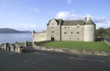
| Parke's Castle | This castle was built by Capt. Roger Parke, incorporating an old O'Rourke castle, probably in the first or second decades of the 17th century. This property eventually came into the possession of the Gore family through the marriage of Anne Parke to Sir Francis Gore. |
|
| Parkearagh | John Keane was leasing this property from Lord Ventry's estate at the time of Griffith's Valuation, when it was valued at £6. A substantial farm is extant at the site now. | |
| Parkgariffe | The representatives of Reverend D. Mahony were leasing a house valued at £9 to Barbara Strange at the time of Griffith’s Valuation. This property was included in the sale of the Freeman estate in 1850, when it was occupied by Mrs. Elizabeth Strange, under a lease dating from 1828. Bary states that it was later lived in by the Spottiswood Green family. There is still an occupied house at the site but it may have been altered. | |
| Parkgarriff | This house was the home of at least two generations of David Cagneys in the 19th century. The house was valued at £40 at the time of Griffith's Valuation and held by David Cagney from Lord de Vesci. The Cagneys were still resident in the 1870s. The house no longer exists and the site is located on the edge of the Monkstown Golf Club. | |
| Parkmore House | Rev. C.Moynahan was leasing this property to Arthur Sealy at the time of Griffith's Valuation, when it was valued at £19 5s. Bary quotes O'Donovan who said it was a set of the Meredith family in the 1830s though she also mentions that it was said to have been built by a Fr. Minahan. It was occupied by members of the Meredith family and later by their descendents and is still extant. Richard Meredith was leasing a second property in this townland to Rev. C. Moynahan which was valued at £5 5s. | |
| Parknasilla | James F. Bland was leasing a house valued at £10 to Christopher Bland at the time of Griffith’s Valuation. Bary states that some historians believe this to be the original Bland house in the area. In the mid 19th century it became known as the Bishop’s House as it was leased by the Bland estate to Bishop Graves of Limerick. Later still it became the forerunner of the Parknasilla hotel, in which grounds it is still located. A second house in the townland is labelled Clashnacree House [V721649] on the 25-inch Ordnance Survey map of the 1890s. In 1894 Slater records this latter house as the seat of J.F. Fuller. It is still extant. | |
| Parkstown | The Lamphiers were resident at Parkstown from at least the 1770s. In 1786 Wilson refers to Parkes-town as the seat of "Mr. Lanphier". Henry Langley lived at Parkstown in 1814 and John P. Lamphier was resident in 1837 and in the early 1850s. Lamphier held the property from the Court of Chancery and the buildings were valued at £23+. John P. Lanphier was the occupant at the time of sale in 1852. This building is still a fine residence. |
|
| Parkswood Cotham | In 1848 George Cotham was leasing this property from Mrs. Eliza McDougall, when it was valued at almost £14. | |
| Parkswood House | Mrs. Eliza McDougall was leasing this property to Edward Strangman in 1848 when it was valued at £33. There is still an extant house where guest accommodation is provided. | |
| Parteen House | At the time of Griffith's Valuation this house valued at £24 was the residence of George Gloster who held it in fee. Weir writes that the house was demolished in the 1920s to make room for the Ardnacrusha hydro-electric dam. | |
| Parteen Villa | Robert Atkins Twiss, second son of Robert Twiss of Cordell House, county Kerry, was living at Parteen Villa in 1837. In 1840 the Ordnance Survey Name Books refer to Parteen Villa as the residence of Thomas Mansell Bradshaw, "a neat house in the cottage [stile]". The house was occupied by the representative of Robert Twiss at the time of Griffith's Valuation, value at £29+ and held from Mrs Margaret Ormsby. Parteen is probably the house at Birdhill occupied by Robert G.E. Twiss in 1906 and valued at £30. A building is still located at this site. | |
| Partry House | Bence-Jones describes the house, situated on the shore of Lough Carra, as Georgian with a Wyatt window above the porch. It is likely that it incorporates an earlier house built in the latter part of the 17th century. In 1786 Wilson mentions "Cloonlagheen" as the seat of Mr. Lynch. It was the seat of the Lynch/Blosse Lynch family for three centuries. At the time of Griffith's Valuation, it was held in fee by Henry Lynch Blosse and valued at £14. Owned briefly by David Shaw Smith in the 1990s, now the home of Lorraine O'Donoghue. |
|
| Pass House | In 1786 Wilson writes that Pass House was the seat of Mr. Peacock. By the time of Griffith's Valuation the house was occupied by Solomon Frost, leasing from the Peacock estate and valued at over £5. The property does not appear on the 25-inch Ordnance Survey map of the 1890s. | |
| Pastor Ville | By the early 1850s the Reverend Edward Larkin was resident at Pastor Ville, valued at £16+ and held from the Earl of Clonmel. The house is labelled Pastorville House on the 1st edition Ordnance Survey map but as Boolahallagh House on the later 25-inch edition of the 1890s. It is now in ruins. | |
| Pastor Ville [Kockboy] | In 1840 the Ordnance Survey Name Books refer to Pastorville as a gentleman's seat and to Micheal Meeghan as the proprietor. At the time of Griffith's Valuation Timothy Meighan held a house at Knockboy valued at £10.15 shillings and 15 acres from Edmund Byrne. This appears to be the house Pastor Ville marked on the first Ordnance Survey map and on the later 25-inch map of the 1890s. Buildings are still located at this site. | |
| Paulsworth | At the time of Griffith's Valuation, Mrs. Maryann Paul was leasing this property to John Power, when it was valued at almost £24. The house is still extant and occupied. |
|
| Peafield | George H. Rawlins was the proprietor of Peafield at the time of Griffith's Valuation, though it was unoccupied. Lewis distinguishes between Peafield and Peafield House which he indicates was the seat of the Minton family. | |
| Peafield (Templemodan) | In 1786 Wilson refers to Peafield as the seat of Archdeacon Mockler. There is no substantial house shown in this area on the 1st edition Ordnance Survey map. By the time of Griffith's Valuation, the townland was in the possession of Thomas Boyce. | |
| Peak | Richard Irwin owned a herd's house and over 370 acres at Peak, barony of Castlereagh at the time of Griffith's Valuation. A modern house has been constructed at the site. | |
| Peake House | Henry Lindsey was resident at Peake in 1814 and his descendant, Catherine Lindsay, still occupied the house in the early 1850s. She held it from Daniel O'Connor and it was valued at £16. A member of the Lindsay family was still residing at Peake in the mid 1870s. A house is still extant at this site. |