Browse Houses
Search Results: Returned 5927 records. Displaying results 4801 – 4900
| House name | Description | |
|---|---|---|
| Redcastle | James S. Doherty held the property known as Red Castle in fee at the time of Griffiths Valuation in the 1850s, when it was valued at £40. Buildings at the site are labelled Red Castle on all editions of the Ordnance Survey map. Now the site of the Redcastle Hotel. | |
| Redcity | In the mid 19th century William Harney held a house valued at £11+ from Sir John Power in the townland of Redcity. Buildings are still located at this site. | |
| Redcliff Lodge / Foildarrig | At the time of Griffith’s Valuation James Hickson held a property, valued at over £21, at Brackloon.On the 1st edition OS map it is labelled Foildarrig. By 1895 it had become known as Red Cliff. Bary states that Hickson built it as a summer residence when he worked as the agent for Lord Landsdowne. It was later owned by the Catholic church and more recently operated as a guesthouse. In 2003 it was offered for sale. | |
| Redhill | At the time of Griffith's Valuation, William Baker was leasing a property valued at £14 at Mullaghroe, barony of Coolavin, from Viscount Lorton's estate. Lewis recorded Redhill as the seat of Andrew Baker in 1837. The house remained in the Baker family until 1912. It is still extant and occupied. |
|
| Redhill House | The Whyte family were resident at Redhill from the 17th century. The first edition Ordnance Survey map (publ. 1837) marks a building in ruins which was the original castle. A house was built to the north east. The Ordnance Survey Field Name Book states that Redhill lately belonged 'to Mr White now in France, estate in Chancery, executors Mr Boyd of Cootehill and Col Clements'. The house 'is a small tho' convenient building with out-houses, the ancient castle in ruins, destroyed by fire 40 years ago.....The house is unoccupied except by a care taker’. Following the death of Francis Melville Whyte in 1833, Redhills was inherited by his niece Georgina Mary Enderby. She married the Reverend Edmund Burke Venables in 1847. Named on the first edition Ordnance Survey map (publ. 1837), Redhills was the residence of the Reverend E.B.W. Venables at the time of Griffith’s Valuation. Valued at £8, he held it in fee. Redhills was the home of the Reverend Arthur Thellusson Oddie in 1905 when he assumed the name and arms of Whyte Venables. In 1906, Georgina Whyte Venables is recorded as occupant when the mansion house was valued at £53.10.0. A building still stands on this site and the gate lodge survives. |
|
| Redmondstown | Redmondstown is named on the first edition OS map and 25 inch map. The National Built Heritage Service records that the main entrance was erected about 1800. In 1814 John Tisdall is recorded as resident. At the time of Griffith’s Valuation (publ. 1854) it was occupied by Frederick Hart who held the house valued at £10 from Jerome Tisdall. The house is now demolished. | |
| Redmondstown | In 1814 Redmondstown was the residence of J. Parson Ducket and in 1837 of a member of the Quinn family. In the early 1850s R.G. Fitzgerald was the occupier, holding the house valued at £16.15 shillings from the Earl of Glengall. This house is still extant and is located in a wooded area. Thomas Albert Quin of Redmondstown owned 612 acres in the 1870s. | |
| Redmounthill Farm | At the time of Griffith's Valuation the property at Ballynamudagh, a steward's house and out buildings valued at £14, were part of the Pollok estate. In 1906 this property was valued at £41. On the 25-inch Ordnance Survey map of the 1890s the buildings are labelled Redmounthill Farm. The house and some portions of the farm buildings remain at the site. |

|
| Redwood | Marked on the first edition Ordnance Survey map as Moatfield House and on later maps as Redwood. Moate-field, Burris-a-kane, was the home of William Clarke in 1814. In 1841 the Ordnance Survey Name Books refer to it as "Moat Field, a good dwelling house the residence of Miss Clarke". In the mid 19th century Robert Daly held a house valued at £15 and 324 acres in Redwood from Lord Bloomfield. Redwood is still extant. | |
| Redwood House | Redwood was the home of the Bloomfield family in county Tipperary, occupied by Major Bloomfield in 1837. In 1840 the Ordnance Survey Name Books mention that Redwood was "a commodious house, at present occupied by a party of the constabulary and also the residence of Mr. Ryan, under-agent to Maj. Bloomfield". It is marked as a police station on the 1st edition Ordnance Survey map. At the time of Griffith's Valuation. Phillip Crawley held the property from Lord Bloomfield and the house was valued at £15. Redwood House later became a Trench home, valued at £18.15 shillings in 1906. It no longer exists. | |
| Reeks View | Rev. William de Moleyns was leasing this property from Lord Ventry's estate at the time of Griffith's Valuation, when it was valued at £4 15s, on a holding of 140 acres. It appears on the 1893 edition of the Ordnance Survey map as Reeks View. It is still extant. | |
| Reen Lodge | Leased by Robert White from the Bantry estate in 1852 when the house was valued at £10+. Noted by Leet as the residence of Rev. William Hodnett in 1814. In the later half of the nineteenth century it seems to have been occupied by the Leonard family. Documents in relation to it exist in the Bantry Estate papers. The Irish Tourist Association survey in the 1940s refer to it as owned by Mr. Regan. It is still extant and occupied. | |
| Reenadisert Court | Leased by Robert Warren from the Bantry estate at the time of Griffith's Valuation when it was valued at almost £6. It was originally a seventeenth century fortified house built by the O'Sullivans and is now in ruins. A second property, Reenadisert Cottage (W000531), appears on the 25-inch Ordnance Survey map of the 1890s but this has now disappeared. |

|
| Reenmeen Cottage | Leased by Robert White from the Bantry estate in 1852 when it was valued at £11+. Named as Reenmeen Cottage by Lewis who notes it as the seat of R. White in 1837. Buildings still exist at the site. A house named Glengarriff Cottage (V939564) appears on the 1st edition Ordnance Map in this townland but is not visible on the later 25-inch map. | |
| Reenmore House | Rev. John Day was leasing a property valued at £12 15s from the Lansdowne estate at the time of Griffith's Valuation. This may have been the conjoined property labelled Sound House and Fir View on the 1st edition Ordnance Survey Map. On the 25-inch map of the 1890s, Sound House has become known as Reenmore House. The are still extant buildings at the site. | |
| Reenydonagan House | Leased by Roger O'Sullivan from the Kenmare estate in 1852 when it was valued at £12. Lewis notes it as the seat of D. O'Sullivan in 1837. The house is still extant and operates as a guesthouse. |

|
| Regaile | In 1840 the Ordnance Survey Name Books record Rev. Mr. Joice as the occupant of Regeale. The Reverend Robert Armstrong occupied the house at the time of Griffith's Valuation holding it from Richard Phillips. The buildings were valued at £20.18 shillings.A house is still extant at Regaile. | |
| Rehill | Rehill was occupied by William Fennell in 1814 and 1837 but by the time of Griffith's Valuation James Mulcahy was resident, holding the property from the Earl of Glengall. The buildings which included a house, offices and corn mill were valued at £62. Sold in 1853 to Robert Murdock and leased by him to Edward Mulcahy. A building is still located as this site. | |
| Renmore House | The residence of Patrick Marcus Lynch and his descendants on the outskirts of Galway from the early 19th century, leased from the Governors of the Erasmus Smith Schools. It was valued at £35 at the time of Griffith's Valuation. The house was sold circa 1924 and became a tuberculosis sanitorium. It is now part of a Health Service facility. |
|
| Rennies Cottage | Built by Luke Joseph Shea in the 1830s, he held this property in fee at the time of Griffith's Valuation, when it was valued at £28 with an adjacent mill. A building is still extant at the site. | |
| Renny | This house, overlooking the River Blackwater, may have been part of the Widenham estate which passed to the Smyths. The site had earlier associations with the poet Edmund Spenser. Wilson, writing in 1786, refers to "Rinny, the seat of Mr. Nagle, which was formerly part of the estate of the immortal Spenser". In 1814 the Reverend C.P. Wallis was the occupant. At the time of Griffith's Valuation the house was occupied by Henry Smith who held the property in fee, the buildings were valued at £23. Henry Smyth advertised the house and 541 acres for sale in May 1851, all it required at that time was a "small outlay in paint and paper to make it at once fit for occupation". In 1885 Walford noted Renny as the seat of John Blackburne. Hajba writes that the last occupant was Captain [Pepper] Roberts. The Earl of Listowel demolished the house following the Captain's death in 1900 though many of the buildings shown on the 1st edition Ordnance Survey map had already disappeared by then. | |
| Renvyle | The house at Renvyle was inhabited by the O'Flahertys in 1811 and was described by Henry Blake in his ''Letters from the Irish Highlands''.The Blakes went to live at Renvyle in the early 1820s and an additional storey was added in the mid 19th century. Run as a guest house in the 1880s, it was bought by Oliver St John Gogarty in 1917. Badly burnt in 1923 he rebuilt it as a hotel. |
|
| Retreat | Retreat was a two-storey, three bay late 18th century house built by Thomas Cooke and located close to the east side of Athlone town. It was occupied by General Hart in 1814, F E Moony in 1837 and by Major Owen Lloyd Ormsby at the time of Griffith’s Valuation (publ. 1854), who held the property valued at £20 from William Cooke. Later occupants of this house were the Costello, Kilduff and Young families. The house and lands were sold to the Athlone Urban District Council in 1998 and the house demolished. | |
| Retreat/Faybrook | Retreat, set in a small demesne close to Dromore River with a corn mill nearby, is named on the first edition six inch Ordnance Survey map (publ. 1837). It appears to have been a Bredin home in the early 1850s. By the time of Griffith’s Valuation it belonged to Thomas Fay and was occupied by James Boyle. The rateable valuation was £10. The house reduced in size, or possibly a new structure, was renamed Faybrook. It is marked on the 25 inch map and is still extant. | |
| Reynella | Reynella House is a seven-bay two-storey country house on T-shaped plan built about 1770 by Richard Reynell. In 1814 it was the seat of Richard M Reynell and in 1837 Lewis records that Reynella was 'the elegant residence of the late R. M. Reynell, Esq., now the property of a minor, situated in a fine demesne, adorned with a lake and extensive plantations'. Valued at £27 it was occupied by John Rynd at the time of Griffith’s Valuation (publ. 1854) and held from Blayney T Balfour. This house was home to the broadcaster Marian Finucane and her husband in the 1980s and was a guest house in more recent years. |
|
| Rhynmount (Rinnmount) | Reverend G. Moore was leasing this property from George J. Mitchell at the time of Griffiths Valuation, when it was valued at £10. It is labelled Rinn Mount on the 1st edition Ordnance Survey map but as Rhynmount on the later 25-inch edition. A modern house exists at this site now. | |
| Ricehill House | Rice Hill was built in the mid-18th century. It was the home of the Bredin family in the first half of the 19th century. It is named on the first edition six inch Ordnance Survey map (publ. 1837). Described by Mulligan as a ‘classic Georgian gentleman’s farmhouse in a small demesne.’ Occupied by Patrick Finnegan and held from the representatives of Sophia Wright in the 1850s, when the buildings were valued at £3.10.0. It was still the home of the Finnegan family at the beginning of the 20th century and continues to be a residence. |
|
| Rich Hill | The residence of the Howley family in the 19th century, held by them in fee and valued at £39 in the early 1850s. Rich Hill was also the childhood home of Captain William O'Shea. |

|
| Rich Hill | A house occupied by Thomas George French at the time of Griffith's Valuation, valued at £20 and held by him in fee. | |
| Richfordstown House | Thomas Lucas was leasing this property from the Smith-Barry estate at the time of Griffith's Valuation, when it was valued at £26. It was the seat of Jasper Evans Lucas in 1814. In the 1870s John R. Lucas was the owner of the property. There is now a large farming enterprise here, as well as a house which may have replaced the earlier house. |

|
| Richfort | James A. Richardson held this property in fee at the time of Griffiths Valuation in the early 1850s when it was valued at £15. Lewis had referred to Richfort as the seat of J.A. Richardson in 1837. In 1814 Leet noted it as the residence of Arthur Richardson. The house was demolished in the 20th century but the entrance gates remain. |
|
| Richmond | Located in the town of Fermoy, Richmond was occupied by H. Smyth in 1837 and by George Walker. It was the residence of the Furlong family in the second half of the 19th century. In the 1920s they sold the house to the Loreto Sisters. Still part of the convent complex at the beginning of the 21st century. |

|
| Richmond | The home of the Mannix family in the late 18th and 19th centuries. Occupied by S. Oliver in 1814 and by R. Mannis [Mannix] in 1837. [Henry Mannix was resident in the early 1850s when the house was valued at £27 and held from Jonas Morris.] A house is still extant at the site. | |
| Richmond | Bence Jones writes that this was a fortified house onto which a three storey house was built in 1733. The house was later altered and expanded. Richmond was the seat of the Gason family in the 18th and 19th centuries, originally known as Killashalloe. Occupied by Richard Gason in 1814 and in 1837 and held by him in fee in the early 1850s when it was valued at £46. This house remained in Gason possession until 1956 when the roof was removed and the farm was sold in 1962. Part of the facade of the Ulster Bank headquarters at George's Quay, Dublin, was constructed from blocks of stone from Richmond House (''The Irish Independent'', 16 March 1999) . | |
| Richmond House (Affane) | Maj John H. Alcock was leasing this property from Henry Dennehy at the time of Griffith's Valuation when it was valued at £29. Lewis also noted it as his seat in 1837. The National Inventory of Architectural Heritage indicates it was also linked with the Villiers Stuart family. It is still extant and occupied. |
|
| Richmond Mill | At the time of Griffiths Valuation in the early 1850s, William Fleming was leasing this substantial site from the Gunning estate when the buildings were valued at £95. The Valuation Office Books note a valuation of £72 in 1840. The property is labelled as a distillery on the 1st edition Ordnance Survey map but as corn mill on the 25-inch map. The ruins of the miller’s house and mill buildings are still visible at the site. |

|
| Richmond Villa | This house valued at £16 in the mid 19th century was occupied by the Westropp family from at least 1814, although a Mrs Wallace was in residence in 1837. The Reverend Fitzgerald records a Mr William Wallace as resident in the 1820s and that the house was built about 70 years previously. It was situated on the Tomkins estate. | |
| Richmount | Richard Sealy held this property in perpetuity in the early 1850s when it was valued at £45.Lewis also notes it as his seat in 1837. It had been a residence of the Sealy family since the early eighteenth century. The site is now occupied by Bandon Grammer School. | |
| Richmount Hill | John Higgins, MD, was leasing this property from Jane Richardson’s estate at the time of Griffiths Valuation in the 1850s, when it was valued at over £15. In 1814 Leet referred to it as the seat of Auchmuty Richardson. The National Built Heritage Service suggests that this house was built c.1720. It is still extant and occupied. |
|
| Rickfield (Skull) | At the time of Griffith's Valuation, Robert Swanton was leasing this property from the Connor estate when it was valued at £6 5s There are still buildings at the site. | |
| Rickfield Cottage (Skull) | Hugh Swanton was leasing this property from the Connor estate at the time of Griffith's Valuation, when it was valued at £5. Buildings are still extant at the site. | |
| Riddlestown Park | The seat of a branch of the Blennerhassett family, built circa 1730, it passed by inheritance to the Knight of Glin. In 1786 Wilson wrote that it was was the seat of Mr. Blennerhasset. Described by Lewis in 1837 as ''the ancient mansion of Gerald Blennerhassett'' on the banks of the Deel. It was held in fee by Gerald Blennerhasset at the time of Griffith's Valuation when it was valued at £22. Passed to the Knight of Glin in the early 20th century and then sold. It is still extant. |

|
| Riggs Villa/Greenhills | Located a short distance north west of Killucan, this building is named Riggs Villa on the first edition OS map and Greenhills on the 25 inch map. It is a three-bay two-storey house, built about 1830, with two-bay two-storey return to the northeast (boi). Riggville Cottage was the home of Edward Riggs in 1814 and of Anthony Fawcett at the time of Griffith’s Valuation (publ. 1854) when it was valued at £11.10 and held from the Earl of Longford. Two Fawcett sisters were living in Killucan at the time of the 1911 census. This house is extant. |
|
| Rigsdale House | Not named on the 1st edition Ordnance Survey map but labelled Rigsdale House on the 25-inch map, published in 1899. At the time of Griffith's Valuation it was described as "herd's house" and being leased by the Wheatley estate to the representatives of Benjamin Roberts. It was valued at £10 at the time. In the early 1940s the Irish Tourist Association survey noted that " there is no trace of the old residence of the family. Richard Bird lives in modern residence of Rigsdale". It is still extant and part of a farming enterprise. |

|
| Rinagry Cottage/Rinagry House | The residence of a junior branch of the Gortnaraby family, described at the time of the first Ordnance Survey as "a neat thatched cottage built in 1807". Rinagry was leased by Edward S. Perry from John Ormsby at the time of Griffith's Valuation, when it was valued at more than £10. An enlarged building is labelled Rinagry House on the 25-inch Ordnance Survey map of the 1890s. It is no longer extant. | |
| Rindaly Cottage | In 1906 the Ashley estate owned a property at Creevymore, barony of Carbury, valued at almost £9. At the time of Griffith's Valuation this property had been in use as an agriculturalist's house on the Palmerston estate, and leased to John Lynch. McTernan notes that Lynch acted as resident agent and land steward for the estate. A second house, adjacent to the first, was leased, at the time of the Valuation, to Rev.Malachy Brennan and valued at over £8. | |
| Rindaly Cottage | Rev. Malachy Brennan was leasing a property valued at almost £10 at Creevymore, barony of Carbury, at the time of Griffith's Valuation. This appears to be the house known as Rindaly Cottage and was leased from Lord Palmerston's estate. | |
| Rindifin Cottage | In 1786 Wilson refers to Rhyndifen as the seat of Prendergast Smyth. Lewis records Rhyndifin as the seat of the Blaquiere family in 1837. It was occupied by Mary Moloney at the time of Griffith's Valuaiton, leasing from the Knox estate and was valued at £4. The entrance gateway is extant and a house still occupies the original site. |
|
| Rineen | The property at Rineen was leased to Daniel O'Dea by Henry Comerford at the time of Griffith's Valuation. It was valued at £26 and included a mill. The National Inventory of Architectural Heritage suggests it was built c.1804 by Count de Basterot. It is now a ruin. |
|
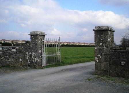
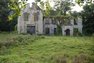
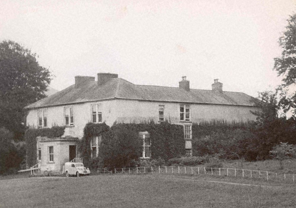
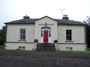
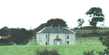
| Rineroe [Fort Union] | The house at this site is labelled Rineroe on the 1st edition Ordnance Survey maps but as Fort Union on the later 25-inch map of the 1890s. It was held by John Christy from the Dunraven estate at the time of Griffith's Valuation and valued at £24. It is still extant and occupied. |
![Photo of Rineroe [Fort Union]](https://landedestates.ie/storage/img/orig/2850.jpg)
|
| Ring Arundal | Jasper Lucas was leasing a house and extensive mill complex from the Smith-Barry estate at the time of Griffith's Valuation, when its combined value was £23. The mill is not present on the 25-inch Ordnance Survey map of the 1890s. The house is still extant. |

|
| Ring Cottage | A house marked as Ring Cottage on the first Ordnance Survey map and occupied by Uniack Mackey in the early 1850s, when held from the Marquis of Thomond and valued at £10. Still extant and now known as Ring House. |
|
| Ring House | Lewis records J. McCarthy as proprietor of Ring in 1837. Thomas Taylor was resident in the early 1850s holding the house valued at £16 from the Marquis of Thomond. Thomas Taylor of Ring owned 76 acres in the 1870s. The house is now an ivy covered ruin. | |
| Ring House | Ring House was being leased by Henry Austin to Henry B. Beamish at the time of Griffith's Valuation, when it was valued at £8 10s. There is still a house at the site. |

|
| Ring View | Ring View was being leased by Robert Baily from the deVesci estate at the time of Griffith's Valuation, when it was valued at £18 10s. A house is still extant at the site. | |
| Ringabella | Samuel Hodder held this property in fee at the time of Griffith's Valuation, when it was valued at £25. Lewis refers to it as the seat of S.A. Austin in 1837. In 1942 the Irish Tourist Association Survey noted that had been a residence of the Austins but was then owned by the McCarthy family. Ringabella is still extant and occupied. | |
| Ringmahon Castle | The proprietor of Ring Mahon Castle in 1837 was J. Murphy. James Murphy occupied the house valued at £68 in the early 1850s and held the property from William Crawford who held from the Chattertons by lease dated 1797. This property was still in the possession of the Murphy family at the end of the 19th century. | |
| Rinneen House & Mills | At the time of Griffith's Valuation, James Swanton was leasing a house valued at £9 at Carrigtishane from Rev, M. Townsend. A mill in the same location (W183333), held by Messers. Swanton, Goold and McNamara, was valued at £56. Information locally suggests that James Swanton built the house. Local sources claim the house was later used by the Catholic Church as the priest's house. It is now a ruin which was offered for sale in 2009. The mill buildings, now disused, are still extant. |
|
| Rinroe House | Rinroe was leased from the Wingfield estate by John Boyd at the time of Griffith's Valuation, when it was valued at £8. It later became a residence of the Ormsby family, relatives of the Ormsbys of Glen, and remained in that family until the 1960s. Earlier, in 1786, Wilson refers to it as "Bunro, the seat of Mr. Leech". The house is still extant. | |
| Rinville House | Lewis records the house at Rinville as the seat of T.L. Athy in 1837. Earlier in 1814 it was the residence of Phillip Athy. At the time of Griffith's Valuation it was valued at £48 and was occupied by Randal Athy. A second property in the townland of Rinville West was leased by the Athy estate to Patrick Blake. In 1906 Rinville was owned by Edmond J. Athy and was valued at £43. It is now an ivy covered ruin. Part of the demesne lands are a public park maintained by Galway County Council. A gate lodge is still extant but unoccupied. A graveyard for the Oranmore area has been established on part of the demesne lands. |
|
| Rinville Lodge | At the time of Griffith's Valuation, Patrick Blake was leasing a house valued at £12 at Rinville West, barony of Dunkellin, from Randal Athy. This appears to be the house known as Rinville Lodge on the first edition Ordnance Survey map. By the 1890s it had become known as Bay View the name by which it is still known. |
|
| River Lawn | In 1839, he Ordnance Survey Name Books describe River Lawn house as "a commodious house, the property of William Poe, in the occupation of E. Radford esq". At the time of Griffith's Valuation, when it was valued at almost £10 it was leased by Augustus H. Going from William Poe. It is still extant and occupied. |
|
| River View | River View was recorded as a seat of the Lopdell family by Lewis in 1837. By the time of Griffith's Valuation it was owned by the representatives of Vicisimus Knox and was being leased by the Vereker estate when it was valued at £5. It is now in ruins. | |
| River View | A mid 19th century house, marked on the first Ordnance Survey map. At the time of Griffith's Valuation this house valued at £27 was occupied by John Able and held from the Reverend Edward Croker. |
|
| River View (Bandon) | Held by Thomas Gash from the Devonshire estate at the time of Griffith's Valuation, when it was valued at £30. A house still exists at the site. |

|
| River View (Dunmanway) | Rev.John Meade was leasing this property from William Norwood in 1851 when it was valued at almost £10. Adam N. Meade of Riverview, Dunmanway, owned 529 acres in county Cork in the 1870s. In 1894 Slater records Riverview as the seat of Rev. George Deacon. A house still exists at this site. | |
| River View (Inishowen) | This property was being leased from Sarah McClintock by Margaret Camac at the time of Griffiths Valuation when it was valued at over £12. Lewis recorded it as the seat of W. Camac in 1837. It was still extant in the mid 20th century but the site is now occupied by a commercial building. Property in this area was owned by Thompson M. McClintock in 1906. | |
| River View (Knigh) | James Kingsley was leasing this property from the Farrar estate at the time of Griffith's Valuation, when it was valued at £10+. In 1840 the Ordnance Survey Name Books refer to River View House as "a commodious dwelling house, the residence of John Tuthill, esq.". Buildings are still extant at the site. | |
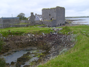
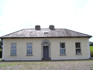
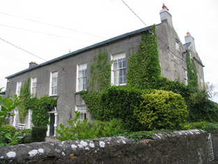
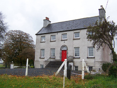
| River View [Donaghpatrick] | This house was occupied by James Kearns in the 1850s, leasing from the Duke of Bedford's estate, when the house was valued at £8. It is still extant and occupied. |
![Photo of River View [Donaghpatrick]](https://landedestates.ie/storage/img/orig/184.jpg)
|
| River Ville [Mulkear] | Built circa 1800 and the seat of Arnold Hill circa 1840 this house was occupied by Samuel F. Dickson at the time of Griffith's Valuation and held by him from William D. Farrer with 206 acres, The buildings were valued at almost £16.The house is labelled River Ville on the 1st edition Ordnance Survey map but as Mulkear on the 25-inch edition of the 1890s. A house is still extant at the site. | |
| Riverdale | Riverdale, located just south east of the industrial complex Shay Murtagh Pre Cast Ltd, it is named on both the first edition six inch and 25 inch maps. Home of W T Briscoe in 1837 and Griffith’s Valuation (publ. 1854) records William Briscoe as the occupant, holding the house valued at £30 from Alexander Montgomery. O’Brien records this house as demolished. | |
| Riverdale House | John Heard was leasing this property from the Stawell estate at the time of Griffith's Valuation, when it was valued at £10. In 1837, Lewis refers to Riversdale as the seat of T. Bailey. It is still extant and occupied. |

|
| Rivers | In 1786 Wilson refers to Rivers as the seat of Brooke Brasier. Only the remains of a driveway and estate buildings are visible on the 1st edition Ordnance survey map of the 1830s. | |
| Riversdale | Built by the Massys in the early 19th century and occupied by Hugh Massy in 1837 and held by him in fee at the time of Griffith's Valuation when the house was valued at £30+. Lynch writes that this house was bought from the Massy Dawsons by John Noonan in 1922, who ran it as a hotel. |
|
| Riversdale | A house occupied by Patrick Hyland at the time of Griffith's Valuation, held from Usher Beere and valued at £15+. | |
| Riversdale | This house was built after the first Ordnance Survey. At the time of Griffith's Valuation Thomas S. D. Robinson is recorded as the occupier of a house valued at £15 in the townland of Ballynavin. He held the property in fee. Thomas S.D. Robinson was still living at Riversdale in the 1870s. This house continues to be used as a residence. |

|
| Riversdale | Matilda Shanley was leasing Riversdale House at Corrachole to William Lawder in the 1850s when it was valued at £12. In 1837 Lewis records it as the seat of the Shanley family. It is still extant and operates as a farm guesthouse. |
|
| Riversdale | In the 1830s the house is described as "on rising ground and in good repair" Held by James Kelly in fee at the time of Griffith's Valuation when it was valued at £22. The original house is no longer extant. | |
| Riversdale (Kenmare) | George Mayberry, MD, was leasing Riversdale from the Lansdowne estate at the time of Griffith's Valuation, when it was valued at £12 5s. Bary states that the house was in the Mayberry family until the early twentieth century when it was pruchased by the Representative Church Body who owned it until the 1960s. It is now an hotel. |

|
| Riversdale (Tedavnet) | This house is marked on the 1st edition 6 inch Ordnance Survey map (1836) and on the 25 inch map (surveyed 1908) it is named. It was located on the outskirts of the village of Bellanode, close to the River Blackwater and to a number of mills. Occupied by Thomas Wright in the mid-19th century and held from Henry Mitchell, the buildings were valued at £6.10.0. A building is still extant at this site. | |
| Riversdale House | John R. French was leasing a house valued at £25 at Kilateasheen from the Ecclesiastical Commissioners at the time of Griffith's Valuation. There is no substantial house marked on the 1st edition OS map. This house is still extant and known as Riversdale House. |
|
| Riversfield | A house located on the Coote estate, occupied by Thomas Weldon in 1837 and at the time of Griffith's Valuation when the buildings were valued at £20. John H. Weldon of Riversfield owned 68 acres in county Limerick in the 1870s. Occupied by Mr and Mrs Watt in 1943. It is still extant. | |
| Riversfield (Upper Ormond) | In 1840 the Ordnance Survey Name Books record Riversfield as " a neat house, the residence of Mr. John Ardill". He was leasing it and the adjoining mills from Mrs.Otway Cave's estate at the time of Griffith's Valuation, when the buildings were valued at £17+. A house and farm buildings are still extant at the site. | |
| Riverston | Leets records Riverstown, Nenagh, as the home of Wills Crofts. In 1806 John Bennett of Cork city married the only daughter of Wills Crofts of Riverston, county Tipperary (''Freeman's Journal'' 12 June 1806). In 1837 John Bennett was the proprietor of Riverston. At the time of Griffith's Valuation John Bennett held the property from the representatives of Peter Holmes and the house was valued at £55 and the nearby mill at £54. The home of a member of the Poe family in the 1870s. |

|
| Riverston | Weir writes that John Tymons was resident here in 1799. James Lysaght occupied the house in 1814 and Jonas Studdert in 1837. At the time of Griffith's Valuation Riverston was the home of Mrs Anne Bolton who held the house from James Timmins, a minor. | |
| Riverstown | The home of the Hackett family in the 19th century, occupied by Simpson Hackett in 1814 and in the 1830s and 1840s. Thomas Hackett was resident in the early 1850s and held the property from the Earl of Rosse. The house was valued at £29+. The Hacketts were still resident in the 1870s. This house is still extant and occupied and situated on the border of counties Tipperary and Offaly. In 2013 it was offered for sale. |
|
| Riverstown | An early 18th century house with fine plasterwork by the Francini brothers, the seat of the Browne family for two and a half centuries. The Brownes were still occupying the house in 1837 but John Carmichael is recorded as the occupier in the early 1850s when it was valued at £32.10 shillings. Restored in the 1960s by the Dooleys with help from the Irish Georgian Society. |
|
| Riverstown House | Riverstown House, originally known as Rathwire House, this five-bay single-storey over basement villa, was built about 1830 and was associated with a former corn mill run by the Hannons (boi). Occupied by Benjamin Hannan, valued at £15 and held from the Earl of Longford at the time of Griffith’s Valuation (publ. 1854). Samuel Clarke, agent and his wife lived here in 1901 and William Bailey, ex RIC and land agent’s assistant and his family were resident in 1911. It was bought by a Father O'Rourke in 1935 who opened the first Camillian Juniorate in Ireland here in 1949, it now functions as St Camillus Care Centre. |
|
| Riverview | Rev. Michael Field was leasing this property from the Frewen estate at the time of Griffith's Valuation, when it was valued at £10. It was burnt in June 1921 during the War of Independence when it was the residence of Col. Francis Godley. Now a ruin. | |
| Riverview | At the time of Griffith's Valuation held by James Browne in fee and valued at £14. It is described as "in ruins" on the 25-inch Ordnance Survey map of the 1890s. | |
| Riverview (Kilculiheen) | Joshua Williams was leasing Riverview from Richard C. Pope in 1849 when the house was valued at £37 10s. There is still an extant house at the site. | |
| Riverview/Cloggy House | River View was situated on the bank of the River Erne. It was obviously associated with linen making in the early 19th century as beetling and bleaching mills are both marked near the house on the first edition six inch Ordnance Survey map (publ. 1837). A corn mill is also shown nearby. The Faris family were resident in Cloggy from at least 1832 when Alexander Faris is mentioned in the Tithe Applotment Books. In the mid-19th century William Faris was resident holding the buildings valued at £15 from Cosby Thomas Nesbitt. Alexander Faris/Ferris, a farmer and his family were living in Cloggy at the beginning of the 20th century. This house has been modernised and still retains a fine range of outbuildings. | |
| Riverville (Currans) | Charles Blennerhassett held this property in fee at the time of Griffith's Valuation, when it was valued at £9 15s. Lewis records Riverville as the seat of Richard Marshall in 1837. The Ordnance Survey Field Name Books record Riverville as the residence of Richard Marshall c.1840, describing it as "a thatched house of oblong shape". Bary states that the house was a seat of the Marshell family and believed to have been built by them in the eighteenth century. They remained there until the 1840s. Later in the nineteenth century it was associated with the Spring family It is still extant and occupied. | |
| Rivoli | Weir describes Rivoli as a late 19th century house to which James Shannon's family moved from nearby Derry House in the second half of the 19th century. It was a home of the Hunt family in the early 20th century. | |
| Roadstown | At the time of Griffith's Valuation Charles O'Connor was leasing the property at Roadstown, barony of Corran from Rev. William Hearne and Capt. Starke, when it was valued at £6.Lewis also records it as the seat of the O'Connor family. In the eighteenth century Roadstown was associated with the Fleming family some of whom are buried in the churchyard of Emlaghfad, near Ballymote. Roadstown House is still standing but derelict. The house and farm were sold in 2005. |
|
| Roan | Dennis Duan was resident here in 1814 and Robert Purcell in 1814. He held the property valued at £18.15 shillings from Matthew Jacob. This house had later associations with the Bianconi family and is still a family home. |
|
| Roaring Water Cottage | At the time of Griffith's Valuation, John F. Townsend was leasing this property to Frances Long, when it was valued at £8. Lewis mentions Roaring Water House as the residence of J. O'Sullivan in 1837. The house is still extant and occupied. | |
| Robe Villa | A town house on the River Robe, home of the Kenny family for 200 years, sold by them in the early 1980s to the Ballinrobe Rugby Club. |
|
| Robinstown | Robinstown House, near the eastern shore of Lough Ennell, a short distance south of the ruined Robinstown Castle. This house is named on the first edition OS map. It is a five-bay two-storey over basement county house, built about 1790. Owned by the Evans family during the first decades of the 19th century it was the residence of W. D'Arcy Irwin in 1837. At the time of Griffith’s Valuation (publ. 1854) it was valued at £12, inhabited by Henry Fetherstonhaugh and held from George A Boyd. |
|
| Rochemount | The residence of a junior branch of the Roche family in the 19th century. Occupied by Francis Roche in 1814 and by John Webb Roche in 1837 and the early 1850s when the buildings were valued at £30. He held the property in fee. In 1894 Slater notes Rochemount as the seat of Francis W.A. Roche. There are still buildings extant at this site. |