Browse Houses
Search Results: Returned 5926 records. Displaying results 4901 – 5000
| House name | Description | |
|---|---|---|
| Rock Castle | Frederick Oldham was leasing this property from Godfrey Baldwin at the time of Griffith's Valuation, when it was valued at £12. By 1865, it was part of the estate of Robert Forster, an insolvent, and was offered for sale in the Landed Estates Court in July of that year and again in January and November, 1866. The sale notice indicates that the lands were held on a lease, dated 1858, from the Earl of Bandon's estate to Thomas Poole. Noted by Leet as the seat of Edward Beecher in 1814. Though there are buildings extant at the site they do not appear to be occupied. | |
| Rock Castle Mill | John and James Gillman were leasing this property to John Hazel at the time of Griffith's Valuation, when it was valued at £8 and the mill at £52. In 1837 Lewis had noted it as the property of Mr. Heazle. It does not appear on the later 25" Ordnance Survey Map, suggesting perhaps, that it had ceased operations by the end of the nineteenth century. | |
| Rock Cottage | Edward Powell was leasing a property to James Somerville,MD, at the time of Griffith's Valuation, when it was valued at £11 10s. In 1837 Lewis noted Capt. Somerville's seat as Union Hall. This house is labelled Rock Cottage on the 1st edition Ordnance Survey map but as Myross Glebe on the 25-inch edition of the 1890s. In 1945 the Irish Tourist Association survey recounted a story associating Dean Jonathan Swift with Rock Cottage and noting that it was the home of the Casey family. A house still exists at this site. | |
| Rock Cottage (Barnahely) | William Warren was leasing this property to Richard Foott at the time of Griffith's Valuation, when it was valued at £11 5s. A house is still extant at the site. | |
| Rock Cottage (Passage West) | Catherine Parker was leasing this property from Thomas Boland in 1850 when it was valued at £36 10s. A house is still extant at the site. | |
| Rock Cottage (Skull) | James O'Callaghan was leasing Rock Cottage from the Earl of Bandon's estate at the time of Griffith's Valuation, when it was valued at £11. In 1837 Lewis had recorded it as the residence of J. O'Callaghan. James O'Callaghan owned over 450 acres in the area in the 1870s. Operated as a guesthouse in the later twentieth century and offered for sale in 2009. |

|
| Rock Farm | The home of John Cantillon in 1837 and in the early 1850s when it was valued at £16 and held from Warren Hastings Rowland Jackson. | |
| Rock House | Edward Gillman held this property in fee at the time of Griffith's Valuation when it was valued at £24. Lewis records the property as the seat of J. Gillman in 1837. It was offered for sale in the Encumbered Estates Court in June 1851. In the late 1770s it was occupied by a member of the Baker family. There is still an extant house at this site. | |
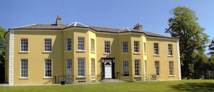
| Rock House | Noone states that this house was built by an Oxford barrister Thomas Birch, post 1838. At the time of Griffith's Valuation it was held in fee by George Clive when the buildings were valued at £30. It is still extant and now serves as guest accommodation. |
|
| Rock House (Ardmore) | Richard Usher was leasing this property from the O'Dell estate in 1851 when it was valued at £18. Though the building is still visible it is not named on the later 25-inch Ordnance Survey map. The National Inventory of Architectural Heritage suggests it may once have been three houses that were amalgamated into one property, possibly in the early nineteenth century. It is still extant. |
|
| Rock House (Cavan) | Marked on the first edition Ordnance Survey map (publ. 1837). In the 1850s, this house was occupied by the Reverend Matthew Webb and held from George Wilton. It had a rateable valuation of £21. It is now the centre of a farming complex. | |
| Rock Island House | At the time of Griffith's Valuation, Thomas Notter held this property in fee when it was valued at £16 10s. In 1837 Lewis recorded it as the seat of J. Notter. Leet refers to Rock-Island as the residence of Henry Alleyn in 1814. It is still extant. |
|
| Rock Lodge | A house on the Donoughmore estate, occupied by R. Carleton in 1837 and by Henry Osborne Seward at the time of Griffith's Valuation when it was valued at £25. A house is still extant at the site. | |
| Rock Lodge | This house was the home of Samuel Harding from at least 1814 to the mid 19th century. He held the property from the Earl of Clare. At the time of Griffith's Valution, it was occupied by Michael Harding and valued at £10. Home of the Behan family at the end of the 20th century. | |
| Rock Lodge (Gaultiere) | Andrew Meade was leasing this property from Lord Waterford's estate at the time of Griffith's Valuation, when it was valued at £14 12s. It is named Rock Lodge on both the First and latre 25-inch editions Ordnance Survey maps. A house is still extant at the site. | |
| Rock View | Rock View, Cashel, was occupied by John Lane in 1814, by Sam Cooper in 1837 and by Mrs Margaret Matthews in the early 1850s. The buildings were valued at £18.16 shillings and held from General Hall. This house, located close to the road between Golden and Cashel, is still occupied. |
|
| Rock View /Airmount House | Thomas Pope was leasing this property to Rev. Martin Flynn in 1850 when it was valued at £31. It is labelled Rock View on the 1st edition Ordnance Survey Map but as Airmount House on the later 25-inch edition. Later the property of the Mahony and MacDonald families. |
|
| Rock Ville (Passage West) | Mrs. Anne Taylor was leasing Rock Ville from the Parker estate at the time of Griffith's Valuation, when it was valued at almost £25. Lewis refers to it as the seat of J. Taylor in 1837. It is still extant and occupied. |
|
| Rockbarton | Also known as Mount Prospect, Fitzgerald describes Mount Prospect as the "magnificent seat and demesne of the present Chief Baron". Lewis describes Rockbarton as the "elegant mansion of Lord Guillamore". It was occupied by John Low at the time of Griffith's Valuation who held it from the Viscount. It was valued at £75. By 1906 the value of the house was reduced to £60 and it was then occupied by Lord Fermoy. The Irish Tourist Association surveyor records the sale of this house to Mr Barry in 1922. It remained in his possession until it was demolished in 1941 and the fittings sold to a Limerick builder. He writes that it was one of the "showplaces of Ireland" with a grand staircase of marble and that it had been renovated at a cost of £70,000 circa 1912 by the Honourable Nigel Baring who was married to a daughter of Lord Fermoy.The house is now a ruin. | |
| Rockborough | Rockborough was the home of T. Mitchel Browne in 1837. Situated on the Hedges estate it was occupied by John G. Browne in the early 1850s, when it was valued at £25. In 1944 the Irish Tourist Association Survey noted that it had formerly belonged to the Brownes but was then the home of the Twomey family. This property is still extant. | |
| Rockbrook | Rockbrook was originally a Phibbs property. It later came into the possession of Abraham Martin of Cleveragh who leased it to the Cogan family and later to the Lougheed estate. It was occupied by John Lougheed at the time of Griffith's Valuation when it was valued at £3. Johnston states that the estate was divided by the Land Commission in the 1920s and that the house was sold by Mrs. Lougheed in 1938. It burnt down in 1945 and only the ruins remain today. | |
| Rockenham | In 1850 Thomas Parsons Boland was leasing this house to Noble Johnson, when it was valued at £100. Lewis refers to it as Johnson's seat in 1837. The National Inventory of Architectural Heritage suggests it was built by the Johnsons in the 1820s. It is still extant and occupied. |
|
| Rockfield | Marked on the first edition Ordnance Survey map, this house was occupied by Henry French at the time of Griffith's Valution and was described as a herd's house. It was valued at £4 and was located on the estate of Lord Oranmore and Browne. Now derelict it was last occupied by the Dillon family. |
|
| Rockfield | A Nash home in the first half of the 19th century, occupied by Christopher Nash at the time of Griffith's Valuation and held from John James Nugent. The buildings were valued at £7. In the 1940s the Irish Tourist Association Survey noted that this property had once belonged to a family called Badham but was afterwards acquired by the Nashs and that "the present house was probably built by the latter family". A house and substantial farm are still extant at Rockfield. | |
| Rockfield | In 1837 Lewis noted that "Rockville" was the property of the representatives of the late John Drew. At the time of Griffith's Valuation, William Whorland was leasing a property valued at £5 10s from the Drew estate. The property was offered for sale by Alicia Wherland in the Landed Estates Court in July 1862 and again in July 1872. In 1906 Rockfield was owned by Bertram Morrogh Bernard and was valued at £11. Bary mentions it as a house associated with the Sealy family. Buildings are still extant at the site. | |
| Rockfield | The residence of Edward Fitzgerald in the first half of the 19th century, held by him from Captain Richard Gloster at the time of Griffith's Valuation and valued at over £11. | |
| Rockfield | Another Mitchell house in the townland of Castlestrange, occupied by D. Merry in 1837 and by David Wakefield in the 1850s. It is not shown on the 25-inch Ordnance Survey map of the 1890s. Rockfield was the home of Christopher and Mary Anne Irwin in 1749. | |
| Rockfield | Situated on the estate of Edward C. Villiers, this house was the home of a branch of the Blennerhassett family in the mid 19th century. It was named Rock View on the first Ordnance Survey map. The Ordnance Survey Field Name Book refers to Rockview as a "plain thatched cottage built in 1819". On the later 25-inch map the house is labelled "Rockfield House". Slater, in 1894, refers to it as the seat of R.B. Blennerhassett. In 1906 Rockfield was described as a mansion house and valued at £22. It was occupied by Richard A. Blennerhassett. A house is still extant at the site. | |
| Rockfield | Rockfield is named on the first edition OS map, this three-bay two-storey house was built c.1785. For sale in 1853 when the 'mansion house' was not in full repair. Mark Colgan was the tenant. It was held on a lease from Nicholas and Francis Evans. At the time of Griffith’s Valuation (publ. 1854) it was occupied by Marcus Colgan and held from John Elliott. It was valued at £13. Joseph Clavin, farmer and his family were the occupants in the early 20th century. This house is till part of a farm complex. |
|
| Rockfield | An early 18th century residence of the FitzGeralds, their first home in the parish of Turlough. In 1786 Wilson refers to this house as Rockfield Lodge, a seat of Charles Lionel Fitzgerald. It is visible but not named on the 1st edition Ordnance Survey map but most of the buildings have disappeared by the publication of the 25-inch map of the 1890s. | |
| Rockfield (Killashandra) | The National Inventory of Architectural Heritage dates this house to circa 1720. The Irish Genealogist Vol II refers to the will of F. Young of Rockfield, 1777. Situated close to Rockfield Lough it was a Berry home in the first half of the 19th century. Thomas Berry was resident in 1814 and in 1851 (Thom’s Directory). Rockfield was advertised for sale in the Encumbered Estates Court in November 1851. A few years later Griffith’s Valuation records Robert O’Brien as the occupant of Rockfield holding it from Oliver Sproul. It was valued at £17. The house is still extant but no longer in use. |
|
| Rockfield (Modelligo) | Pierce Hely held this property in fee at the time of Griffith's Valuation, when it was valued at £33 10s. Wilson, writing in 1786, refers to "Rockville" as the seat of Mr. Hely. The house is still extant and occupied. The National Inventory of Architectural Heritage notes its association, not only with the Hely family, but also that of English and Grove-White. |
|
| Rockfield (Moysnaght) | A house on the Lucas estate, approached by a long avenue, it is marked on the 1st edition 6 inch Ordnance Survey map (1836). The extended house is named on the 25 inch map (surveyed 1908). In the mid-19th century it was occupied by Joseph Gray and valued at £14. John Gray and his family were resident in 1901. Occupied by William Morrison and his wife in 1911. A building is still located at this site. McSkane writes that this house was built around 1850 for Mr John Niblock and the Niblocks lived here until 1900 when it was bought by John Gray an RIC officer (local informant). A Letitia Niblock was resident in this townland in the mid-19th century. Later the home of James Agnew. | |
| Rockfield House | Melvin states that throughout the 18th and 19th centuries the house at Rockfield was occupied by Burkes, Brownes, Blakes and Concanons. At the time of Griffith's Valuation it was occupied by Patrick J. Blake and was valued at £26. In 1837 Lewis recorded it as the home of M. Browne. Wilson, writing in 1786, refers to it as the seat of Michael Browne. In 1906 it was owned by Richard A. Nugent when it was valued at £27. The Encumbered and Landed Estates Court sale notices give the impression that the house was sometimes known as Rockville. Though the house no longer survives the gate lodges are still occupied. |
|
| Rockfield House (Avalreagh) | Rockfield House, a home of a branch of the Swanzy family, is named on the 1st edition 6 inch Ordnance Survey map (1836). Lewis refers to it as the residence of H. Swanzy. Henry Swanzy died in 1843 and his daughter Anne is recorded as the occupant in the 1850s when the house was valued at £14. Miss Kate Green Swanzy was the head of the household living here in 1901 and 1911. There was a name change to Avalreagh House at the beginning of the 20th century. McSkane writes that the Swanzy family lived here from the early 1700s until 1919 when it was bought by Larry Ward. | |
| Rockfield House (Raphoe South) | John Johnston was leasing this property from the Conyngham estate at the time of Griffiths Valuation in the 1850s, whe it was valued at £20, with an adjacent mill valued at £14. The current house appears to have been built after the publication of the 1st edition Ordnance Survey map in the 1830s. The National Inventory of Architectural heritage provides a detailed chronology of its occupation by the Johnston family. |
|
| Rockfield House (Tirhugh) | Patrick Brady was leasing this property from the Conolly estate at the time of Griffith’s Valuation, when it was valued at £13. It is labelled as Rockfield House on the 25-inch Ordnance Survey map of the early 20th century. It is still extant. |
|
| Rockfield Tower | At the time of Griffith's Valuation held by Tobias Delmege from Lord Southwell and valued at £9. This house is still in use as a residence. |

|
| Rockfield/Cromlyn | A house known as Rockfield (N295657) is named on the first edition OS map at the southern end of Glen Lough. The lands and house were leased to John Crawford by Sir Peter Nugent in 1795. Matthew Crawford was resident in 1814. A later house a short distance to the east was built by the Crawfords in the late 1840s according to the sale rental of 2 December 1862, ‘The house, which is a spacious and well-built mansion erected within the last fifteen years at an expense of upwards of £2,000 … The house contains on the basement-story nine rooms, including kitchen, wine-cellar, scullery etc with every accommodation for servants. There are on the first floor four large reception-rooms, one dressing room, two pantries, bath-room etc. On the second floor, seven commodious and well-proportioned sleeping apartments besides bathrooms etc.’ This house was originally known as Rockfield and was valued at £36 at the time of Griffith’s Valuation (publ. 1854) when occupied by Matthew Crawford. The name of the house may have been changed to ‘Cromlyn’ when it was purchased by Charles John Battersby of Ballinalack in 1862. It is named as Cromlyn on the 25 inch map (circa 1914). The house remained in the possession of the Battersby family well into the 20th century. |
|
| Rockfleet Castle | An O'Malley castle, owned by the Arbuthnots at the end of the 18th century. By the time of Griffith's Valuation, the townland was in the possession of William B. Stony, leasing from Captain A.W. Wyndham. The castle ruin is still extant. |
|
| Rockford | The original house was marked on the first edition Ordnance Survey map but it was enlarged and altered sometime after the first Ordnance Survey. Another house also known as Rockford House was built to the south east of the original house in 1881 for Theobald Richard Wolfe, Grid Ref R855 821. It remained in the possession of the Wolfe family until 1943. Rockfort (sic) was the residence of Jeoffrey Kingsley in 1814 and of J. Wolfe in 1837. In 1823 John Wolfe married Frances Elizabeth Kingsley, an only child. John Wolfe held the house valued at £18 and 232 acres from the representatives of General Chowe in the early 1850s. The Wolfes were still resident in the 1870s. |

|
| Rockforest | Originally a Hutchinson property, incorporating the old castle of Knockballymaher, which passed to Edward Corker Minchin following his marriage in 1848 to Sarah Anne, only child by his first marriage of William Henry Hutchinson. Stephen Minchin was the occupier at the time of Griffitih's Valuation holding the property from Edward Minchin. The buildings were valued at £16. ''Burke's Irish Family Records'' states that Rockforest was sold in the Encumbered Estates' Court in 1852 and the Minchins emigrated to New Zealand. It appears to have been bought by William Gibson, father of Captain William Gibson who was residing at Rockforest, Roscrea in the 1870s. This house is now demolished but the outbuildings and stables still remain intact. |
|
| Rockforest | A home of Bindon Blood throughout the first half of the 19th century and later of his son, Bagot Blood, who died in 1897. It was held in fee by Bindon Blood at the time of Griffith's Valuation, when it was valued at £12. The house shown on the 1st edition Ordnance Survey map was replaced by a later house a short distance away. A house is still extant at this site. | |
| Rockforest | The seat of the Cotter family from the mid 18th century and occupied by them until the 20th century. Wilson, writing in 1786, describes it as "a most beautiful improvment, highly wooded, situated on the Blackwater, the seat of James Laurence Cotter". Occupied by Mrs J.R. Cotter, sister-in-law of the 3rd Baronet, in the mid 19th century when the buildings were valued at £18. By 1906 its value had risen to £38.15 shillings. Only half of the house now survives, the Irish Tourist Association Survey of 1942 noting that "the greater part of the building had been knocked down". For sale in 2012 through Savills. |
|
| Rockforest Lodge | This house was the residence of Pierse Creagh in 1837. At the time of Griffith's Valuation Henry O. Seavers occupied this house, valued at £24 and held by him in fee. This house is still inhabited. In 2010 it was offered for sale. see http://www.michaelhdaniels.com/index.cfm?fuseaction=propsearch |
|
| Rockfort | Valued at £4 in the mid 19th century when it was occupied by Thomas Bourke who held from David Ruttledge. The Westport Estate Papers contain two 17th century maps of Levallyroe in the possession of Gerald Dillon and held from the Blakes. The Malones also had an interest in Levallyroe and Boleyboy. | |
| Rockfort House | This house was the property of John Hornibrook at the time of Griffith's Valuation when it was valued at almost £9 and unoccupied. The house is still extant. He was also the owner of the nearby Rockfort Mill [W526587], valued at almost £13 and leased to Johanna Hurley. The latter property is labelled "disused" on the 25-inch Ordnance Survey map of the 1890s. |
|
| Rockfort Lodge | Charles Rochfort was occupying this property at the time of Griffith’s Valuation, leasing from the Dickson estate. It was then valued at £20. The house is still extant but does not appear to be in good repair. | |
| Rockgrove | The seat of the Dring family in the 18th and 19th centuries, valued at £50 in the early 1850s. Bence Jones writes that it was sold by the Drings in the early 20th century, valued at £80 in 1906, and was restored in the 1970s. The house is now used as offices. |
|
| Rockgrove | A house valued at £18.10 shillings was held by John Good from John Carney at Rockgrove in the early 1850s. John Good is also recorded as resident in this house by Lewis in 1837. | |
| Rockhill | Occupied by John Burne in 1814 and described as a tolerably good farmhouse at the time of the first Ordnance Survey. Occupied by E. Hodson in 1837 and by Thomas Wilson who held it from James Wilson in the 1850s. Thomas Wilson was still resident in the 1870s. |
|
| Rockhill House | The earlier house at Rockhill was the residence of Daniel Higgins in 1814. At the time of Griffith's Valuation, it was occupied by Dominick D'Arcy and was valued at £9. A new house appears to have been built in the latter half of the nineteenth century and, in the 1870s, it was the seat of Lionel D'Arcy. Rockhill is stil extand and well-maintained. |
|
| Rockhill House (Raphoe North) | At the time of Griffiths Valuation in the 1850s, Rockhill was held in fee by John Vandeleur Stewart when it was valued at £55. Local sources suggest the house was acquired by Stewart from the Chambers family in the 1830s. O'Carroll discusses the ownership by the Cooch and Pratt families of the Rockhill estate. In 1814 Leet had recorded Daniel Chambers as the occupant of Rockhill. By 1906 it was owned by Alexander C.H. Stewart and valued at £52. Later in the 20th century it served as a base of the Irish Defence forces. It is now a luxury hotel. |

|
| Rockingham | Sir Robert King, Viscount Lorton, built Rockingham House around 1810 and the family moved there from King House in Boyle. At the time of Griffith's Valuation Rockingham was valued at £180. In 1903 Rockingham became the county residence of the Lord Lieutenant Lord Dudley. It was destroyed by fire in 1957 and subsequently demolished. Only some of the servants' tunnels as well as other estate buildings remain. The site is now occupied by Lough Key Forest Park. |
|
| Rockingham House (Waterford) | At the time of Griffith's Valuation Richard W. Morris was leasing this property from Mrs. Elizabeth Hassard, when it was valued at £65. The building at this site now is named Rockenham Court. | |
| Rockland House | Rockland House, now the Athenaeum Hotel, was leased by the Ray family to William Snow at the time of Griffith's Valuation. It was valued at over £52. The hotel history indicates it was built in the early nineteenth century by the White family who had major shipbuilding interests in Waterford at that time. See www.athenaeumhousehotel.com for more information. | |
| Rocklands | A house occupied by various agents to the Earls of Lucan, including Ellison, Davis and Larminie. In 1786 Wilson refers to it as the seat of Mr. Ellison. At the time of Griffith's Valuation, it was occupied by Neal Davis, holding from the Earl of Lucan, and valued at £15. The site appears to be occupied by a larger modern building. | |
| Rocklands (Oranmore) | Rocklands was occupied by George Ingham in the 1850s when it was valued at £13. In 1906 it is recorded as the property of Isabella Ussher and was still valued at £13. The house is still extant and occupied. |
|
| Rocklawn | The OS Name Books give the name of this house as Rockland and state that it was the residence of the Browne family though they claim that the townland of Pollaghrevagh was the property of Lord Clanmorris. At the time of Griffith's Valuation it was occupied by James French and was valued at £12. By 1906 it was owned by Richard French. Rocklawn House is no longer extant. It is described as "in ruins" on the 1933 printing of the 6" OS sheet for Galway. |
|
| Rocklow | Taylor and Skinner records Rocklowe as the residence of Lowe Esq in the 1770s. Rocklow was the home of Benjamin Frend and his wife, Eliza Gough, in the first half of the 19th century. Benjamin was resident there from at least 1814 to the 1850s. Griffith's Valuation records that it was held from Hugh Barton and was valued at £37+ in the early 1850s. This house later belonged to the Massys and is still in use as a residence. In 2022 it was offered for sale. |
|
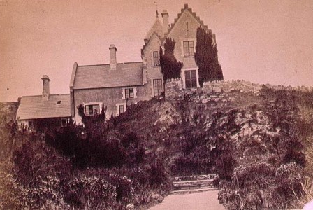
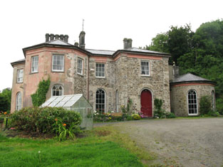
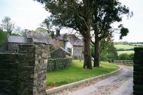
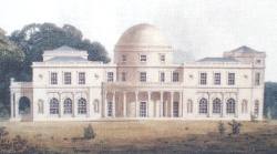
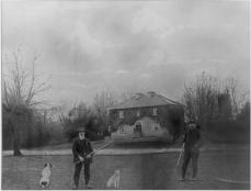
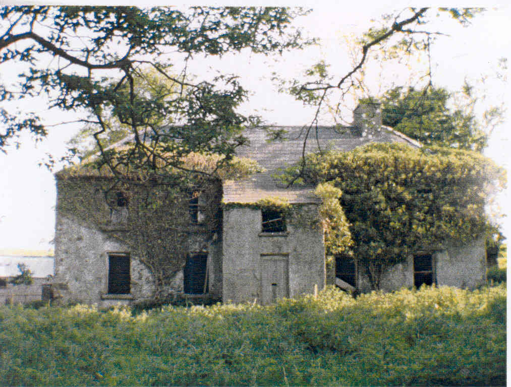
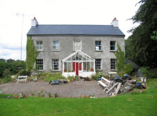
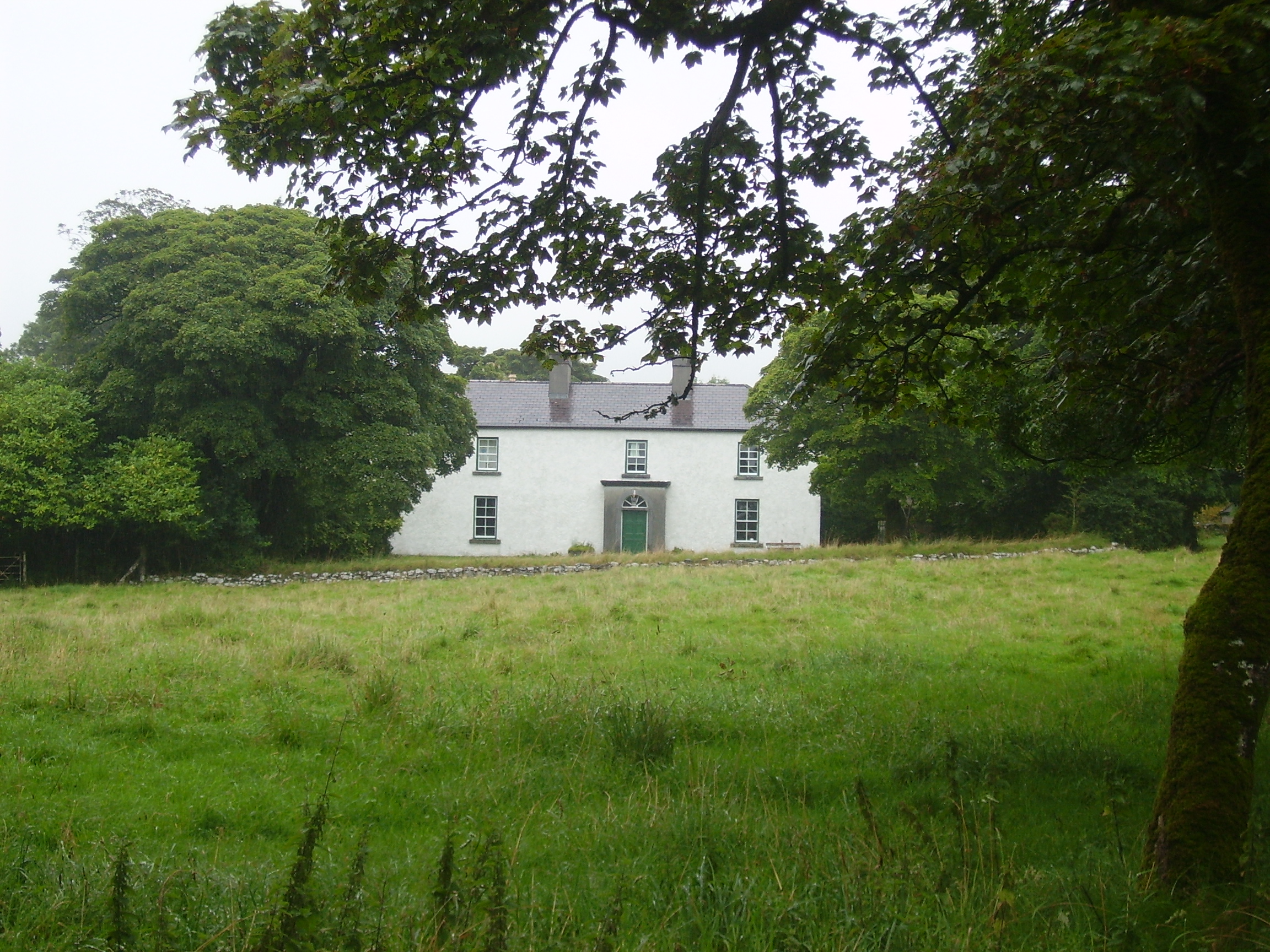
| Rockmills Lodge [Rockmills House] | The lodge was the residence of Colonel Richard Aldworth in 1814. Hajba writes that it was built as a shooting and fishing lodge by Colonel Richard Aldworth in 1776 and that he left the property including the mills to his wife's nephew, Charles Deane Oliver (grandson of Robert Oliver of Cloghanodfoy). Occupied by Mrs Sarah Oliver in 1837 and at the time of Griffith's Valuation and held by her from the representatives of Bond Lowe. The buildings were valued at £25 and she was leasing a flour mill and other buildings valued at £170 to P.L. Lyster. This property was advertised for sale in June 1856. The house was burnt in May 1921 during the War of Independence when it was the residence of Charles Deane Oliver. In 1942 the Irish Tourist Association Survey noted that it had been rebuilt by the Walsh family and was then (1942) occupied by the Casey family. It is still extant. The mills are now in ruins. |
![Photo of Rockmills Lodge [Rockmills House]](https://landedestates.ie/storage/img/orig/1591.jpg)
|
| Rockmore or Blakeland Lodge | . This property is named as Blakeland Lodge on the 1st edition OS Map and in the Ordnance Survey Name Books.It appears as Rockmore on the 25-inch map of the 1890s. At the time of Griffith's Valuation it was occupied by William Kelly and valued at £15. In 1906 it was the property of Raymond Kelly and was still valued at £15. It is still extant and has recently been renovated. |
|
| Rockmullan House | Marked on the first edition Ordnance Survey Map (1836). In the mid-19th century occupied by the Rev James J. Rowley and held from Thomas T. Rowley, when the rateable valuation was £12. The home of the Lavelles in the 20th century. | |
| Rocksavage | This house was the home of the Plunkett family from about the mid-18th century. By the mid-19th century, valued at £25, it had become the home of Charles Plunkett Kenny or Kenney, whose mother Charlotte had inherited the property. Charles still lived there in 1901 and his daughters in 1911. The house is now a ruin. | |
| Rocksavage | This house was not built at the time of the first edition Ordnance Survey circa 1840. Built for John Craven Mansergh [in the 1850s] on land that formerly belonged to the Martin family. In 1942 the Irish Tourist Association Survey reported that Rocksavage was the residence of Dr. Foley. This house, situated close to the Awbeg River just south of Castletownroche, is still extant. | |
| Rocksavage | The home of Waldrons and Ormsbys in the 18th century.In 1786 Wilson refers to it as the seat of Mr. Waldron. The residence of Jeffrey French in 1814 and occupied by Mr Smith at the time of the first Ordnance survey and by Samuel Hodson who held it from William Longfield in the 1850s. Occupied by Robert O. Longfield in 1906. A modern house now occupies the site but some old farm buildings still remain. |

|
| Rockshire House | Leased by Samuel Grubb from Richard C. Pope at the time of Griffith's Valuation, when it was valued at £62 10s. In 1837 Lewis refers to Rockshire as the seat of the Hon. Mrs. Greene. The building is still extant and occupied as apartment accommodation. |
|
| Rockspring | In 1837 Lewis referred to Rockspring House as the seat of W. Coates. He was still the occupier recorded in the Valuation Office books in 1840, when the house was valued at almost £9. By the time of Griffith Valuation in the early 1850s the property was being leased by James O’Keeffe from John Cooke. A house is still extant at the site. | |
| Rockstown | Marked on the first edition Ordnance Survey map this house was occupied by William Nally at the time of Griffith's Valuation and held from the Lynch Blosses. The National Inventory of Architectural Heritage notes its connections with P.W. Nally, a member of the Irish Republican Brotherhood and a well-known late nineteenth century athlete influential in the founding of the Gaelic Athletic Association. The house is now a ruin. |
|
| Rockstown House | A building valued at £18 at the time of Griffith's Valuation, occupied by Chartres Brew Maloney and held from James Kelly. Chartres Brew Molony, second son of Patrick Molony of Cragg married his cousin Alice, daughter of James Barry of Rockstown, in 1841.Rockstown Castle was inherited by James Kelly's grandson, Basil James Kelly, in the 20th century and was left by him to his nephew Derrick Morley in 1945. It is still extant |

|
| Rockvale | Originally a D'Arcy home, built in the 1780s. Rockvale was the home of J. D'Arcy in 1837. By the time of Griffith's Valuation the house was occupied by John Mullins and valued at £7. 10 shillings. Mullins was leasing from the Marquess of Thomond. It is labelled Rockvale House (Constabulary Barracks) on the 25-inch Ordnance Survey map of the 1890s and is now a ruin. |
|
| Rockvale | Reverend M. Moore was the proprietor of Rockvale in 1837. In 1840 the Ordnance Survey Name Books note it as the seat of Rev. A. Armstrong and describe it as " a commodious dwelling house". Francis J. O'Neill was the occupier in the early 1850s. He held the house, offices and flour mills, valued at £61 from John F. Waller. A house is still located at this site. | |
| Rockvale | Lewis refers to this recently erected mansion of Samuel George Beamish. In the early 1850s it appears to be unoccupied and valued at £12, the land was held by Michael Kelleher from S. G. Beamish. This house no longer exists. | |
| Rockvale (Castletownroche) | At the time of Griffith's Valuation, Leslie O'Callaghan was leasing this property from Eustace estate when it had a valuation of £8. In 1942 the Irish Tourist Association survey noted that the ruins of what had been a Nagle property were still visible to the rear of Rockvale. The Survey also recorded that Leslie O'Callaghan, who "had lived there about 100 years ago" had been killed in Cork and that the property had come into the ownership of the Annesley estate. It was later sold to the Patterson family and the house is still extant. |
|
| Rockview | David Cagney was the lessor of several properties in Crookhaven at the time of Griffith's Valuation. One of these was Rockview, leased to Frederick Monks and valued at £11. In 1837 Lewis had noted Rockview as the seat of Florence McCarthy. It is not marked on the 25-inch Ordnance Survey map of the 1890s. | |
| Rockview | In the possession of the O'Loghlens for most of the 19th century. John Kerin occupied the house in 1814, R. O'Loghlen in 1837 and Bryan O'Loghlen at the time of Griffith's Valuation. A house is still extant at this site. | |
| Rockview | A 2 storey house on the Croker estate, built in 1837 for £400, it was occupied by George Peacock circa 1840 and in the early 1850s when it was valued at almost £12. There is still an extant house at the site. |

|
| Rockview (Ballygunner) | In 1848, James Shannon was leasing this property from the Roberts estate when it was valued at £15 3s. The original house does not appear to be extant. | |
| Rockview (Clashmore) | Leased by Richard Bayley from the Villiers-Stuart estate at the time of Griffith's Valuation, when it was valued at almost £7. It is labelled Rockview on both the 6-inch and 25-inch Ordnance Survey maps. There is still an extant house at the site. | |
| Rockview (Decies) | Joseph N. Power was leasing this property from Sir Edward Kennedy's estate in 1851 when it was valued at £14 10s. On the 25-inch Ordnance Survey map of the 1890s it is named as Rockview. The house is still extant. | |
| Rockview (Dorrha) | In 1840 the Ordnance Survey Name Books refer to Rockview House as "a good mansion house, the residence of Captain Corrigan". By the time of Griffith's Valuation this house was occupied by John Hemsworth, leasing from Mary Nunn and representatives of Richard Donovan. The buildings were valued at almost £7. Rockview House is still extant. |
|
| Rockview (Inch) | In 1837 Lewis refers to the "very pretty residence of Mr Fitzgerald" proprietor of the extensive limestone quarries at Carrigacrump. The house was named Rockview on the first Ordnance Survey map. Teresa Fitzgerald was the occupier in the early 1850s holding the property from Colonel William H.M. Hodder, the buildings were valued at £15. Teresa Fitzgerald (nee Coppinger of Rosmore) married James Fitzgerald and they had a son Maurice and daughters Teresa, Mary etc see ''The Barrys of County Cork''. Margaret Fitzgerald of Carrigacrump owned 83 acres in the 1870s. Her estate at Rockview was advertised for sale a number of time in the mid 1870s. There is still an extant house at the site. | |
| Rockview House | Rockview House is a three-bay three-storey building over a basement. It was built in the early 19th century (but not recorded by Leet) for the Fetherstonhaugh family. In 1837 Mrs Richard Fetherstonhaugh was resident. At the time of Griffith’s Valuation (publ. 1854) her son Richard occupied the house, valued at £70 and held from Thomas J Fetherstonhaugh. The Fetherstonhaugh family continued to occupy the house well into the 20th century and it remains a private residence. |
|
| Rockville | At the time of Griffith's Valuation occupied by Michael Mockler and held from the representatives of Matthew Hendly, the buildings were valued at £26. The Mocklers advertised the sale of their interest in July 1851 and July 1853. The sale rental records the lease of Rockville by Ferguson Hendley to the Reverend James Mockler for 3 lives in July 1841 and that £2,000 had been spent on the house. Caroline Bourke occupied a mansion house with 37 acres in the townland of Licklash in 1906. It was valued at £60. In the 1870s Michael Bourke of Lecklash owned 37 acres. This house later became a summer home of Sir Oswald Mosley. Also known as Isleclash House. |
|
| Rockville | The Barrys were inhabiting Rockville by the mid 18th century. William Barry was resident in 1814 and his seventh son Thomas Barry in 1837. In the early 1850s Garret Barry was occupying this house which he held from Sir William Clarke. It was valued at £15.15 shillings. | |
| Rockville | The family home of the Radley family in the 18th and early 19th century. Occupied by Cornelius Ahern and held from the representatives of Henry Longfield at the time of Griffith's Valuation. The buildings were valued at £9.15 shillings. | |
| Rockville | Home of the Lloyd family in the 18th and 19th centuries. Valued at £45 in the 1850s. Sold in 1917 to George Frayne of Ballaghderreen. Demolished in the second half of the 20th century. |

|
| Rockville (Ballyshannon) | At the time of Griffiths Valuation in the 1850s, this property was being leased to Mary O'Neill by Edward Jones. Local sources suggest, however, that it was a residence of the ffolliott family and burned in the 1920s. | |
| Rockville (Carbury) | Edward Homan was leasing two properties, both valued at over £4 and described as Bathing Lodges, at Culleenamore, from Samuel Barrett, at the time of Griffith's Valuation. One house is noted on the OS 1st edition sheet as Rockville and the second as Bocage. | |
| Rockville (Crossdoney) | Named on the first edition six inch Ordnance Survey map (publ. 1837), Rockville was located on the Nesbitt estate to the north east of Lismore Castle, on the outskirts of Crossdoney. In the 1830s it was the home of John C. Tatlow and in the 1850s of Samuel Moore, when the buildings were valued at £20 for rates. Occupied by Dr John Stirling Greer and his wife in 1901 and held from Thomas Cosby Burrowes. Another medical family named Hallowes was resident in 1911. Apparently still extant and occupied. | |
| Rockville (Inishowen) | This property was leased by John Canning from the Harvey estate at the time of Griffith’s Valuation, when it was valued at £14. The site also included a flax mill valued at nearly £5. The National Inventory of Architectural Heritage suggests it was built c.1800 and served as a residence for the local Presbyterian minister at times during the 19th century. Rockville is still extant and occupied. | |
| Rockville (Loughkeen) | The Ordnance Survey Name Books refer to Rock Ville House in the parish of Loughkeen as the residence of Mr. S. Lloyd in 1841. At the time of Giffith's Valuation, a house in this townland valued at £10 was occupied by William Kent, leasing from Jane Downs. On the 25-inch map of the 1890s this house is labelled Carrig Cottage. It is still extant. | |
| Rockwell | Wilson refers to Rockwell as the seat of Andrew Roe in 1786. In 1814 and 1837 John Rowe/Roe was living at Rockwell. By the time of Griffith's Valuation John Bushe was the occupant, holding the property from the Court of Chancery. The buildings were valued at £40.16 shillings. John Bushe was the resident in May 1856 when the estate was advertised for sale. The buildings were altered and added too in 1865 after the arrival of the Holy Ghost Fathers who started a school. This school still operates as one of Ireland's well known boarding school. http://www.rockwellcollege.ie/missionstatement.html |
|
| Rockwell | The main residence of the Lynch family throughout the 19th century, valued at £13 in the mid 1850s. |
|
| Rockwood | John Galway is recorded as the owner of Rockwood at the time of Griffith's Valuation when it was valued at £20. In 1906 Rockwood House was owned by Robert W. Holmes and valued at £20. It was occupied by the Holmes family until after WWI. It was later the property of the Fox family. It was restored in the mid-1980s and is now extant and occupied. |
|
| Rockwood | At the time of Griffith's Valuation Hester Cullen was leasing a house valued at £10 at Deerpark, barony of Rosclogher to Thomas Davis, MD. A house still exists on the site of the original Rockwood House. | |
| Rodeen | A Falkiner residence from at least 1837. It was the home of Joseph Falkiner who held the property in fee. He was one of the eleven sons of the Reverend R.D. Falkiner of Mount Falcon. The house was valued at £22. It was advertised for sale in July 1860, Mrs Anne Falkiner and Richard J. Falkiner were the tenants. The house came on the market again in May 1867, part of the 105 acres for sale at Rodeen, the estate of Octavius La Touche. This house is still in use as a residence. |

|
| Roden House | In 1841 the Ordnance Survey Name Books describe Roden House as "a good dwelling house". C.W. Hemsworth is noted as the proprietor. At the time of Griffith's Valuation, it was occupied by Thomas R. Deane, leasing from Thomas Hackett, when the buildings had a valuation of almost £3. The National Inventory of Architectural Heritage dates this property to 1784. It is still extant and occupied. |
|
| Roebuck | Roebuck was a Lynch home from at least the early 19th century when Edward Lynch was recorded as resident in 1814. Lewis records W. Reilly as the proprietor of Roebuck. In the 1850s Joseph Lynch was the occupant recorded in Griffith’s Valuation, when the buildings were valued at £15 and held from the Representatives of William O’Reilly Adams. By 1906, Henry Galligan was occupying this 'mansion' house valued at £15 for rates and 365 acres of untenanted land. | |
| Roesborough | Occupied in the 1770s by Sadler Esq. In 1786 Wilson states that it was the seat of James Roe. Occupied in 1814 and 1837 by James Roe and in the early 1850s by his son George who held the property in fee. The house was valued at £32.15 shillings. The representatives of Richard Sadlier were the tenants of Roesborough in 1873. This house is now a ruin. |

|