Browse Houses
Search Results: Returned 5926 records. Displaying results 5201 – 5300
| House name | Description | |
|---|---|---|
| Shannon Grove | Originally the home of the Bury family, Earls of Charleville, overlooking the Shannon estuary. The Ordnance Survey Name Books record this house as four-storied, built in 1709. Bence Jones dates this house from the early 18th century. Lewis writes that Shannon Grove was the old family mansion of the Earls of Charleville and "now the residence of Bolton Waller". Bolton Waller held the property in fee in the early 1850s when the buildings were valued at £43 and the demesne was over 400 acres. Bought by John Sheehy of Askeaton in 1860 and remained in the possession of his descendants until the mid 20th century. The house is still extant and occupied. |
|
| Shannon Grove | Located on the estate of Sir Edward Fitzgerald this house was occupied by John Coffey at the time of Griffith's Valuation. The property was sold to the Hegarty family in the 1920s. It was labelled Shannon Grove on the 1st edition Ordnance Survey map but as Crow Hill on subsequent editions. A house and extensive farm are still extant at the site. | |
| Shannon Hill (Derryvunlam) | Edward Matthews occupied Shannon Hill House at Derryvunlum, barony of Leitrim, at the time of Griffith's Valuation when it was valued at £18. In 1906 the house at Derryvunlam, known as Shannon Hill, was still valued at £18 and still in the hands of Edward Matthews. There is still an extant house at the site. |
|
| Shannon Lodge | Alexander or Alick Faris leased property from the St. George estate in Carrick-on-Shannon. His wife Diana is recorded as the occupier of the house known as Shannon Lodge at the time of Griffith's Valuaiton, when it was valued at £30. Pyle states that after Alick Faris died Diana married a French aide of the St.George's, Victor de l'Herrault. She resided at Shannon Lodge for some time but after her second husband died she moved to Sligo and rented Shannon Lodge to her brother, James. She died in 1890. |
|
| Shannon Lodge | Occupied by Mr William White circa 1840, by the early 1850s the house was vacant and held from Thomas William O'Grady. It was valued at £16+. Also known as Stradbally House it was destroyed by fire in December 1983. | |
| Shannon Middle | James Henderson was leasing this property from the Earl of Erne's estate at the time of Griffiths Valuation in the 1850s, when it was valued at £11. It is labelled Shannon Middle on all editions of the Ordnance Survey maps. Substantial farm buildings exist at the site now. | |
| Shannon Park | The residence of the O'Ferralls from at least 1814 when occupied by Michael O'Ferrall. Michael Richard O'Farrell was the occupier at the time of Griffith's Valuation and the house worth £10+ with 146 acres was located on the Brown estate. | |
| Shannon View | It was valued at £22+ at the time of Griffith's Valuation, occupied by Thomas Kelly and held from Henry O. Seward. Thomas Kelly was an uncle of James Michael Kelly of Rockstown Castle and Cahircon. He married Letitia Roche, a granddaughter of Philip Roche of Shannon View and his wife, Margaret Kelly of Limerick. This house is no longer extant and extensive urban development has taken place in the area. | |
| Shannon View | A house on the Vandeleur estate, occupied by S. O'Donnell in 1814 and by Simon O'Donnell at the time of Griffith's Valuation. Buildings still exist at the site. | |
| Shannon View | Close to the shore of Lough Derg, this house is marked on the first edition Ordnance Survey map. In 1840 the Ordnance Survey Name Books refer to it as "a good dwelling house". At the time of Griffith's Valuation it was occupied by Anne Talbot, held from the Reverend Benjamin Talbot and valued at £4.10 shillings. Frances Talbot of Shannonview owned 42 acres in the 1870s. It is still extant. |
|
| Shannon View | Belinda C. Madden is listed as the lessor of two properties in the townland of Kilnaborris, parish of Clonfert, in 1855. The property which appears to have been known as Shannon View was vacant at this time. It was valued at £12. In July 1889 property at Kilnaborris, or Shannon View was offered for sale in the Land Judges' Court by William C. Bermingham Ruthven. The sale was adjourned. In 1783 Taylor and Skinner had recorded it as a residence of the Madden family. In 1786 Wilson refers to Kilnaborris as the seat of Mr. Madden. The National Inventory of Architectural Heritage suggests the house now extant on the site was built c.1870. It suffered fire damage in the twentieth century but was rebuilt c.2002. The house is now known as Lairakeen. |
|
| Shannon View (Tarbert) | At the time of Griffith's Valuation, Richard Hinde held a farmhouse at Coolnanoonagh, valued at £2 15s. A house labelled Shannon View appears at this location on the 25-inch edition Ordnance Survey map, published in the 1890s. A house is still extant at the site. | |
| Shannonvale House & Mill | At the time of Griffith's Valuation, the Misses Newman were leasing this property to T. & J. Allen, The house was valued at £25 and the mill at £225. Lewis records it as the seat of T. Allin in 1837. The mills afterwards became the property of the Bennett family and later of the Rank company and continued in business until 1963. The house is still extant. In 1786 Wilson refers to a house in this area as "Mount-Shannon, the seat of Dr. Calnan". |
|
| Shannonvale/Kilteelagh | Occupied by Mrs Bunbury in 1814 and J. Odell in 1837. The Ordnance Survey Name Books describe it as "a spacious building, the residence of Mr. Cashel" in 1841. Peter Bailey was the occupier in the early 1850s, when the property was held from Mary Nunn. The buildings were valued at £10+. In the 1860s this house was replaced by a new building slightly to the north known as Kilteelagh House. It was built for Lieutenant Colonel W.C. Gason and is still a residence. It was offered for sale in 2012. Anoher Bayley property, known as Hazel Point Cottage, is located close by at R801860. |
|
| Shantonagh House | Lewis writes in the 1830s of Chantinee ‘in the demesne of which are some fine waterfalls’ the home of J. Tilly Forbes. In the early 19th century Chantinee or Chantony was visited by Maria Edgeworth on one of her tours when the house was occupied by James Corry. The first edition 6 inch Ordnance Survey map shows a house in the townland of Shantonagh but there is a larger house in the townland of Tooa which on the 25 inch map is named Shantonagh House. At the time of Griffith’s Valuation this house was valued at £25 and held by Thomas Rothwell in fee. It was burnt in early July 1921. | |
| Shanvally | Thomas Blennerhassett was leasing this property to Robert Conway Hurley at the time of Griffith's Valuation, when it was valued at £20. n the 1830s the Ordnance Survey Name Books describe it as the seat of Thomas Blennerhassett, who had built it in 1835. In 1786 Wilson had noted a seat of the Blennerhasset family close to the Rowan house, Ratanny. Bary states that Shanvally was built by the Blennerhassetts as a hunting lodge, possibly in the late eighteenth or early nineteenth century. It is still extant and occupied. | |
| Shanvogh | Weir describes this house as 18th century. It was occupied by Timothy Cullinan at the time of Griffith's Valuation. He held it from the Marquess of Conyngham and it was valued at £12. The house is still extant. | |
| Sheean Lodge | Built in 1871 and occupied by the artist Paul Henry, in the early 20th century, when he was part-time paymaster for the Congested Districts' Board. "Sheon" Lodge, Ballycroy was the home of General Sir John Davis in 1901. Now known as Shean Lodge and serves as guest accommodation for the Shean Lodge Fishery. |
|
| Sheehills House | Occupied by William H. Minchin at the time of Griffith's Valuation and held with 874 acres from the Earl of Portarlington. The buildings were valued at £15.10 shillings. The Reverend John George Birch occupied buildings valued at £19+ and 880 acres of untenanted land at Thesheehys in 1906. A building is still located at this site. | |
| Sheen Cottage/The Falls | George Woodhouse was leasing a property valued at £6 from the Lansdowne estate at the time of Griffith's Valuation. On the 1st edition OS map the house in this townland is named Sheen Cottage. On the 25-inch map of the 1890s it is labelled The Falls. It is now the Sheen Falls Lodge hotel. See www.sheenfallslodge.ie. |

|
| Sheep Glen | John H. Wheatley was leasing this property to Michael Roberts at the time of Griffith's Valuation, when it was valued at £7 10s. It is still extant and occupied, situated on a large farm. | |
| Sheepstown House | Sheepstown house is named on the early 20th century 25 inch OS map. At the time of Griffith’s Valuation (publ. 1854) it was occupied by James Seery, valued at £15 and held from the representatives of Robert M Tighe. The Seery family were still resident at the beginning of the 20th century. This house is extant. | |
| Sheepwalk | James McGann was leasing a property at Sheepwalk, barony of Frenchpark, valued at £10, from Lord de Freyne's estate at the time of Griffith's Valuation. The townland of Sheepwalk contains a fine collection of early to mid-twentieth century houses and associated farm buildings. One house, now derelict, appears to be earlier and has large associated outbuildings. |
|
| Sheheree Cottage | Captain Denis Curtayne was leasing a property from Lord Kenmare’s estate at the time of Griffith’s Valuation, when it was valued at £17 5s. In 1885 Walford mentions Edward Morrogh Bernard "of Sheheree". Bary also states that the property was later associated with the Morrogh Bernard family. In 1994 it was still extant and occupied. | |
| Shelburne | The National Inventory of Architectural Heritage (buildings of Ireland) states that this was a home of William Petty-FitzMaurice (1737-1805), 2nd Earl of Shelburne and 1st Marquess of Lansdowne. The Ordnance Survey Field Name Book refers to the building of Shelburne in 1837 at a cost of £2,000. Circa 1840 it was the seat of H.N.Seymour. At the time of Griffith's Valuation it was occupied by a representative of Robert Gabbett and held from the Marquess. It was the home of Thompson Russell in 1878 and of Henrietta Rose in 1887. Now located in the grounds of Ardscoil Rís. |
|
| Shelburne Lodge | In 1786 Wilson refers to "the Earl of Shelburne's lodge at Kenmare". William Lawrenson was leasing Shelbourne Lodge at the time of Griffith's Valuation when it was valued at £10. The lessor is named as Garrett Riordan though Bary states that the house was part of the Lansdowne estate and may, in the eighteenth century, have been used by the estate agent. It has had several owners since its sale in the early twentieth century but is still extant and now run as a guesthouse. See www.shelburnelodge.com |

|
| Shellfield (Kilmacrenan) | Nathaniel Stewart was leasing this property from the estate of Eliza Young and Thomas Lecky at the time of Griffiths Valuation, when it was valued at £12. In 1837 Lewis referred to it as the seat of N. Stewart. It is labelled Shellfield on all editions of the Ordnance Survey maps. The National Inventory of Architectural Heritage suggests it was built in the middle of the eighteenth century. It is still extant and well maintained. |

|
| Shepperton | Castlekeale and Shepperton or Shepherdsfield houses were both located in the townland of Ballysallagh West. Weir writes that the Fitzgerald family moved from Castlekeale to Shepperton in the latter part of the 18th century. The house appears to have been leased out to many different people, such as John Wrixton in 1814, John Gabbutt in 1837 and Captain William J. Owen in the 1850s when the house was valued at £22. Weir writes that the house is now demolished. | |
| Shepperton | John Townsend held this property in fee at the time of Griffith's Valuation, when it was valued at £20 10s. Noted by Lewis as the seat of M. Townsend in 1837 and by Leet as the residence of Jonas M. Townsend in 1814. Shepperton is still extant but in poor repair. |
|
| Sheskin Lodge | A hunting lodge built by the McDonnell family and later owned by the Jameson family, now in ruins. | |
| Shinagh House | Leased by Thomas Banfield from the Devonshire estate in 1851 when it was valued at £18. Local sources suggest that the Banfields had resided there since at least the 1690s. This building is labelled Shinagh House on the 1st edition Ordnance Survey map but has disappeared by the 1890s when Shinagh House is shown some distance north-east of the original site at W457555. A business centre now occupies the site. | |
| Shinan House | Shinan House was the home of a branch of the Adams family from the early 19th century. Lewis records ‘Shenan’ as the residence of E. Wilson. By the mid-19th century it was valued at £50 and was owned and occupied by Captain Benjamin Adams. Charles Adams was in possession of Shinan House in the early 20th century. It was later demolished. | |
| Shinglis House | The 1906 Survey of Untenanted Demesnes indicates John Malone as the owner of a property at Shinglis, valued at almost £32. The 1st edition Ordnance Survey map shows the ruins of Shinglis Court adjacent to this site but the 25-inch map labels Shinglis House a short distance to the north-east. O'Brien provides a detailed account of the evolution of the houses at this site, notably those occupied by the Malone family. He notes that Shinglis was demolished in the 1970s. | |
| Shinnagh House | Daniel Coltsman Cronin was leasing Shinnagh House from the Kenmare Estate at the time of Griffith's Valuation when it was valued at £14 8s. In 1837, Lewis refers to "Shannagh House" as the seat of H.O'Sullivan. Bary indicates that it was occupied by the Sullivan family for much of the nineteenth and into the twentieth centuries. It later passed by inheritence to the O'Keeffe family. | |
| Shinnanagh | Valued at £6 at the time of Griffith's Valuation and occupied by Gartside Shea who held the property from Edmund O'Flaherty. Some ruins remain at the site. | |
| Ship-pool | Lewis refers to Shippool as the seat of Captain Herrick in 1837 when he describes it as " a handsome residence in a wooded demesne". At the time of Griffith's Valuation, it was being leased by Thomas Herrick to William Herrick and valued at £50. Local sources suggest it was built in the later eighteenth century when the family moved from Shippool Castle, but the house burned down later in the nineteenth century. It is recorded in the late 1770s as the residence of Herrick esq. and by Leet in 1814 as the seat of Wm. M.H. Herrick. A later house, also called Shippool, was built at the site in the early twentieth century and is still extant. Note: townland spelt as Skanagore in the Townlands Index but as Shanagore in other sources |
|
| Shirley House | Shirley House located in the town of Carrickmacross is named on the 1st edition 6 inch Ordnance Survey Map (1836). It was the home of the agent, George Morant junior, in the 1840s and 1850s and was occupied by Shirley family members and others at various times, for example Alexander Mitchell in 1837 (Lewis, I, xlvii), Horatio Shirley of Shirley House was High Sheriff in 1872, John Thomas Holland of Shirley House died on 14 October 1881 aged 74 (The Belfast Morning News, 18 Oct 1881), Captain Evelyn Shirley was resident in 1914 and Felix Patrick Smith in 1925 (Thom’s Directory 1926). This house is now demolished. | |
| Shore House | The O'Gradys lived at Shore House from at least the 1820s. Jane O'Grady held the house from John Bindon Scott at the time of Griffith's Valuation, when it was valued at £14.10 shillings. Jane O'Grady married Daniel O'Connell of Kilgory. The home of the Hogan family at the end of the 20th century. |
|
| Shorecliffe House | Occupied by the Rev. William Baldwin at the time of Griffith's Valuation, when it was valued at £11. It is named Prospect House on the 1st-edition Ordnance Survey map but as Shorecliffe House on the 25-inchmap of the 1890s. It is still known by this name. It was offered for sale in 2015. |
|
| Shrone Hill | Shrone Hill or Shronell House is a mid 18th century house. In 1786 Wilson describes it as "once a magnificent building of the late Mr. Damer, now belonging to Lord Milton and in ruins". It was occupied by the Sadlier family in the 18th and 19th centuries. The Ordnance Survey Name Books refer to it as the residence of William Sadlier in 1840. At the time of Griffith's Valution the house was valued at £20 and leased by Clement Sadlier from the Earl of Portarlington. It is still extant. |

|
| Shrulegrove | The ruin of the castle at Shrulegrove remains as a prominent feature in the village of Shrule. On the Ordnance Survey map of 1838 a substantial house and gardens are marked in the townland of Shrulegrove. All the townland, including a herd's house and offices valued at £1, were held by Richard Golding from the Duke of Bedford at the time of Griffith's Valuation. |
|
| Shurock | The Homan family appear to have settled at Shurock in the early 18th century. The original house at Shurock was built sometime in the eighteenth century, with a later single-storey Gothic wing added at the end of the eighteenth century. This house was the home of Captain Homan, about 1760 and of Sir W Jackson-Homan (barrister) in 1837. Sir William was created a baronet in 1801. The house is marked but not named on the first edition OS map and the building later expanded as shown on the 25 inch map. O’Brien states that the house was sold in the Encumbered Estates Court and it must have been purchased by George Fleming as he was the occupant at the time of Griffith’s Valuation (publ. 1854) holding it in fee. It was valued at £23. The house is now a ruin. |
|
| Sidebrook House | Sidebrook house is marked on the first edition OS map and named on the 25 inch map. It is a four-bay two-storey house built in the early 19th century and may incorporate the fabric of an earlier house. Taylor and Skinner record a Rochfort Esq at Sidebrook in their maps surveyed 1777-1783. It was later in the ownership of a J. Rochfort in 1837. At the time of Griffith’s Valuation (publ. 1854) John Rochfort held the house valued at £11 with 600 acres from Cooper Rochfort. In the possession of the Lawrence family for most of the 20th century. |
|
| Sillahertane House | John B. Warren was leasing this property from Richard Orpen at the time of Griffith's Valuation, when it was valued at £8 10s. It is named on the 1st edition Ordnance Survey map as Sillahertane Cottage though Lewis records it as Sillerdine Cottage in 1837. Bary indicates that it was also known as Sillahertane House and Warren's Lodge.The house later came into the possession of Francis Wise Low, of Kilshane, county Tipperary, who extended it in the early years of the twentieth century. In 1906 it was owned by Sarah S. Lowe and valued at £40. It was burnt in 1921 and is now a ruin. It forms part of a 500-acre sporting estate which also includes a self-catering holiday home, dating from the 1870s. See www.sillahertane.com.for an in-depth history of the estate. |
|
| Siller House | On the 1838 Ordnance Survey map Siller House is marked as a substantial residence in the townland of Kilcloony. However by the time of Griffith's Valuation there was no house of more than £2 valuation in the townland of Kilcloony. There is no house at this location on the 25-inch Ordnance map of the 1890s. | |
| Silver Spring House | This building was originally a charter school. By the mid 19th century it was occupied by Charles Bianconi, valued at £16 and held from Mrs Putland and Sir Charles Hulse. Mrs Anne Moore lived here in the 1870s. It is no longer in use. |

|
| Silverfort | Silverfort was the home of a branch of the Scully family throughout the 19th century. Jeremiah Scully was resident in 1814, in 1837 and in the early 1850s when he held the house valued at £18.10 shillings from George Carlton. Jerome J. Scully was tenant in November 1857 and still resident in the mid 1870s. This house is still in use as a country home. |
|
| Silvermines Cottage | In 1840 the Ordnance Survey Name Books describe Silvermines Cottage as "a neat and comfortable cottage, the residence of Rowan P. Cashell". He was also the occupier at the time of Griffith's Valuation, leasing from Lord Dunalley's estate. The property was valued at £10 15s. The National Inventory of Architectural Heritage states that it was, for a time, the mine manager's house, for the nearby mines. Silvermines Cottage is still extant and well-maintained. |
|
| Silverstream House | At the time of Griffith's Valuation John Shaughnessy was leasing a property valued at £5 from the estate of John Aylward, which was the subject of chancery proceeding. A building still exists at the site. | |
| Singland House | A building labelled Singland House, in the townland of Singland, appears on the 1st edition Ordnance survey map of the 1830s. A smaller property, labelled Singland Cottage, is shown nearby. On the later 25-inch map of the 1890s, the original Singland House is no longer visible and Singland Cottage is named Singland House. It is no longer extant. The original Singland house is probably that referred to by Wilson as the seat of Mr. Dwyer in 1786. | |
| Sion Cottage | At the time of Griffith's Valuation, John Levis was leasing this property to Eliza Townsend when it was valued at £8 5s. This may be Eliza Hungerford, who was married to Rev. Richard Boyle Townsend. A building still exists at the site. | |
| Sion Lodge | ||
| Sionhill House | Rev. Alexander Alcock was leasing this property from the Pope estate at the time of Griffith's Valuation when it was valued at £46 10s. It is still extant and famous for its gardens which are open to the public at certain times as well as offering guest accommodation. |
|
| Skahanagh House | At the time of Griffith's Valuation, James Kingston was leasing this property from the French estate, when it was valued at almost £6. It is labelled Skahanagh House on the later 25-inch Ordnance Map. There is still a house at this site. | |
| Skeaf House | Herbert Gillman was leasing this property from William Austin at the time of Griffith's Valuation, when it was valued at £20 15s. Lewis recorded it as the seat of W. Austin in 1837. Together with other Austen property it was offered for sale in the Encumbered Estates Court in June 1851. In the 1870s it was the residence of John E. O'Sullivan though it was offered for sale by him in the Landed Estates Court in April 1880 when it was described as "a fine residence". A house still exists at the site. |
|
| Skehaghard | Built by Allen Dowell circa 1840. Occupied by Edward Dowell at the time of Griffith's Valuation when it was valued at £32. Advertised for sale in 1855 and bought by Alan Pollock. A lithograph and long description of the house are included in the sale rental. It was the home of Pollock's steward, George Lowe, for a time and leased to Martin J. McDonnell from 1883-1912. Taken over by the Congested Districts Board in 1918, the house was demolished in 1919. |
|
| Skehanagh | George Lloyd was living in a house valued at £16 at Skehanagh North in the mid 19th century.The Ordnance Survey Name Books note "Skehana" as the residence of George Richard Lloyd in 1840. In the 1870s Horatio M. Lloyd of Skehana, Templemore owned 182 acres in county Tipperary. Catherine Lloyd was resident in 1906. This house burnt down and the present building on the same site dates from the early 20th century. |

|
| Skreeny | Skreeny seems to have been built during the 1690s. It is recorded as a seat of the Cullen family by both Taylor and Skinner and Wilson in the 1780s. During the Famine period it was used as a temporary fever hospital. The townland was in the possession of the Earl of Leitrim by the time of Griffith's Valuation where the only buildings recorded area a gate house and offices, valued at £1 10s. Skreeny House is labelled as "in ruins" on the 25-inch Ordnance Survey map of the 1890s. The Irish Tourist Association survey of the 1940s recorded that it was "the ruins of one of the principal gentry seats in the area". | |
| Slacksgrove/Hollywood House | Slacksgrove is marked as a long building close to the shore of Slacksgrove Lake on the 1st edition 6 inch Ordnance Survey map (1836). It was named after the family who lived there in the 18th century. John Slack of Slacksgrove was High Sheriff of county Monaghan in 1758. Lewis records R. Jackson as resident at Slacke’s Grove in the 1830s. A later square house on the same site, known as Hollywood House, was built before Griffith’s Valuation of the mid-19th century. This house with an extensive farmyard was valued at £36. It was occupied by James Fiddes who held the property from Thomas Coote. Edward Fiddes and his daughter lived in the house in the early 20th century. Only the outbuildings of Hollywood House still remain. | |
| Sleehaun House | This property is not shown on the 1st edition OS map but is labelled Sleehaun Ho on the 25-inch edition of the early 20th century. It was occupied by Michael Ledwidge at the time of Griffiths Valuation in the early 1850s when it was valued at £13 and leased from the Fox estate. The National Built Heritage Service suggests it was built c.1850. It is still extant. |
|
| Slevoir | Lewis records R. Monsell as resident at Slevoir in 1837. The Reverend Francis Synge was the occupier at the time of Griffith's Valuation, holding the property from the representatives of Mr Steele. The buildings were valued at £34. The National Inventory of Architectural Heritage states that the present house was built in the Italianate style in the 1870s for Lieutenant Colonel J.F. Hickey by John McCurdy. In the early 1940s General Carlos J. Hickie was the owner and the house contained very beautiful furnishings and valuable family pictures according to the Irish Tourist Association surveyor. This house sold for over £3 million in 2000 and was offered for sale again in 2011. |
|
| Slievardagh | In 1906 John H. Lanphier held buildings valued at £18+ in the townland of Blackcommon part of the village of Commons, probably Slievardagh House. This house is not marked on the first edition Ordnance Survey map. |
|
| Slieve Russell House | Slieve Russell House was a two storey Victorian lodge, built about 1880 for the Benison family. John Joseph Benison and family were resident in the early years of the 20th century. The house is now derelict. | |
| Sliganagh | At the time of Griffith's Valuation, Hugh Gray was leasing a property valued at £3 to Sarah Trimble, at Sliganagh, barony of Drumahaire. | |
| Smith Hill | Smithhill was in the demesne of The Palace at Elphin. It was the residence of the Reverend Oliver Jones, grandfather of Oliver Goldsmith, in the early 18th century. It was the home of Robert Jones Lloyd in the late 18th and early 19th century and of the Reverend John Lloyd in 1837. The house was unoccupied at the time of Griffith's Valuation when it was valued at £8 and held by Robert Lynch. The Ordnance Survey Field Name Books record that Goldsmith's father was born at Ardnagowna [or possibly Oliver himself, see http://en.wikipedia.org/wiki/Smith_Hill_(house)]. |
|
| Smithfield | Originally a Aylmer residence, later leased by the Smith family. The house was occupied by Richard Smith in 1814 and by R. Smith in 1837, later in the possession of the Fergusons. A 3 storey hand drawn house is depicted on the sale rental map of the Aylmer estate. Smithfield House is now the centre of a working farm run by the Lowe family and offers Bed and Breakfast accommodation. |

|
| Smithstown | Both Taylor and Skinner and Lewis refer to Smithstown as a seat of Viscount Powerscourt in 1778 and 1837. John O'Brien held the house and 117 acres from Edward Wingfield Stratford at the time of Griffith's Valuation. Weir writes that the house was demolished by the Land Commission in the 1940s.. | |
| Smithstown House | Ruane writes that the house was built by the Palmers and became a Royal Irish Constabulary barracks. It was the home of the Pugh family in the 1830s. The only building in the townland at the time of Griffith's Valuation, of more than £2 valuation, was the barracks. Sold in 1988 and now the home of Mrs Loretta Clarke Murray and family. |
|
| Smithville | Rev. M. Townsend was leasing this property to Eleanor Townsend at the time of Griffith's Valuation, when it was valued at £12 10s. | |
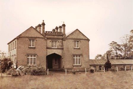
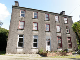
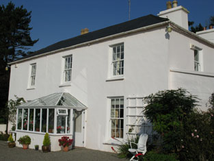
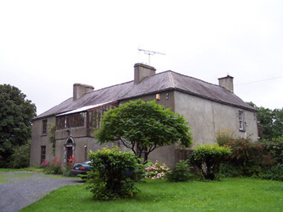
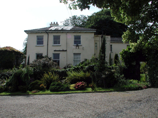
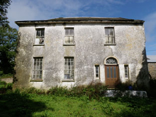
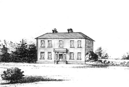
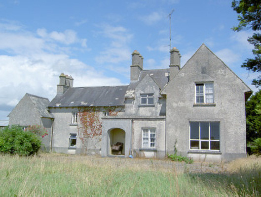
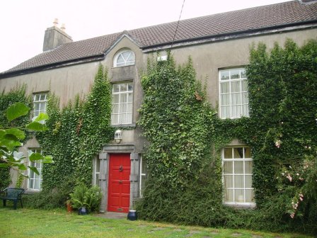
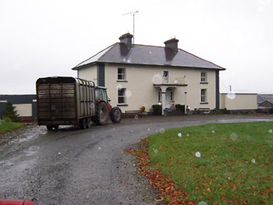
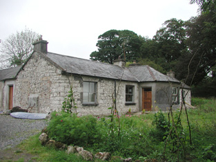
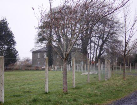
| Smithville [Yewstown House] | In 1840 the Ordnance Survey Name Books refer to Smithville "a commodious dwelling house", the residence of Mr. Boucher, though Peter Homes is mentioned as the proprietor. At the time of Griffith's Valuation, Aquilla Smith, MD, was leasing a property from the Holmes estate valued at £38. In addition Smith was leasing another property, valued at £15, to the Nenagh Poor Law Guardians, for use as an auxiliary workhouse. By the publication of the 25-inch Ordnance Survey map of the 1890s, a more substantial house at the site has become known as Yewston House. The building at the site now is known as The Manor and is in use as a nursing home. |
![Photo of Smithville [Yewstown House]](https://landedestates.ie/storage/img/orig/2843.jpg)
|
| Smorane House | Sampson French was leasing this property to Gibbs Ross at the time of Griffith's Valuation, when it was valued at £8 10s. A house still exists at the site. | |
| Snugborough | In 1786 Wlson refers to Snugborough as the seat of Mr Smith. Mrs. Helena Greaves was leasing this property to Richard Walsh in 1851 when it was valued at £10 10s. An extensive farmyard complex still survives at the site. |

|
| Snugborough | A property leased from the Brownes of Raheens, the O'Malleys built a house here in 1765, costing £900. It was badly damaged in 1798 and was recorded to be in a dilapidated state in the Ordnance Survey Name Books. It is labelled as Snugborough House on the 1st edition Ordnance Survey map of 1838 but is not labelled on the later 25-inch edition and nothing now remains. | |
| Snugmore | Snugmore House was being leased to William Newenham by John Daunt at the time of Griffith's Valuation, when it was valued at £10. It is no longer extant. | |
| Soho (Multyfarnham) | Soho, an early 19th century three-bay two-storey house, is named on the first edition OS map. Inherited by Lattin Fitzgerald, a younger son of Catherine Nugent of Donore and her husband Pierce Fitzgerald, who occupied the house in 1814. At the time of Griffith’s Valuation (publ. 1854) it was the residence of Peter Nugent Fitzgerald, valued at £15.15 and held from Sir Percy Nugent of Donore. The house was occupied by Mrs Margaret Fitzgerald’s gardener Edward Fay in 1901 and by Colonel Edward Irwin and family in 1911. Soho is still a family home. |
|
| Solsborough | In 1786 Wilson refers to "Sallborough" as the seat of Mr. Poe. T. Poe was residing at Salisboro in 1837. At the time of Griffith's Valuation (1850) James J. Poe held the property from the Court of Exchequer. The buildings were valued at £41. At the time of the 1852 sale James J. Poe was the tenant holding the property on a 7 year lease pending the cause of Crofts v Poe. Henry H. Poe of Solsborough owned 314 acres in county Tipperary in the 1870s. This house is now a ruin. |
|
| Somerset | The National Inventory of Architectural Heritage states that this house was built in 1875. It appears to have replaced an earlier house also known as Somerset marked on the first edition Ordnance Survey map circa 1840. In 1841 the Ordnance Survey Name Books refer to Somerset as "a small demesne and good dwelling house, the residence of Mr. Going". It was the home of John O'Meara in the mid 1870s. In 1906 William H. O'Meara occupied a house valued at £12+ in the townland of Abbeville. |
|
| Somerset Glebe | At the time of Griffith's Valuation William Seymour was leasing a property in the townland of Somerset, parish of Clontuskert, valued at £11 to Rev. Adolphus Drought. This property is now a ruin. | |
| Somerset House | At the time of Griffith's Valuation, Thomas Stratford Eyre was leasing a house valued at £20 to William Seymour. Slater refers to the house as the residence of Thomas Craddock in 1894. In 1906 the property at Somerset was held by Charles Seymour. The original house is not extant but there are extensive remains of estate architecture. |
|
| Somerton | Somerton House appears to have been the residence of the agent to the Perceval estate. At the time of Griffith's Valuation the latter estate was owned by R.W. Hall-Dare. Somerton was then occupied by Christopher L'Estrange and was valued at £14. It is still extant. |
|
| Sonna | Set in a substantial demesne as shown of the first edition OS map, the building is slightly altered in shape from this map to the 25 inch map. The house was a three-storey, seven-bay mid-18th century Palladian style mansion. It was the home of the Tuite family and remained as such until it was burnt in 1921. Described in 1837 by Lewis - ‘Sonna for upwards of six centuries, the seat of the Tuite family, is at present the residence of Hugh Morgan Tuite… the house is a light and elegant building, in a well planted demesne’. O’Brien gives a detailed account of the family. The estate consisting of 638 acres was sold to the Land Commission in 1928. See https://www.tuites1.com/424198848.html |
|
| Sonnagh | Walter McDonagh was leasing a property at Sonnagh, parish of Fohanagh, barony of Clonmacnowen, from the Clancarty estate at the time of Griffith's Valuation. He was also the occupier of a mill at Pollboy, valued at £95, in this parish. His estate was centred on Lowville in the barony of Kilconnell. A house still exists at the Sonnagh site. | |
| Sopwell Hall | Apparently named after an English property, Sopwell in Hertfordshire, which was inherited by the Sadleir family. In 1655 a Cromwellian soldier, Colonel Thomas Sadleir, was granted Kinelagh Castle, county Tipperary, which he renamed Sopwell Hall. This property remained in Sadleir possession until it was inherited by Mary Sadleir who, in 1754, had married Frederick Trench of Woodlawn, county Galway, the parents of the 1st Lord Ashtown. The present house was built by Mary's father, Francis Sadleir, in the mid 18th century. Wilson refers to it as the residence of Mr. Sadlier in 1786. Sopwell Hall was left to Francis Trench, brother of 1st Lord Ashtown, who was living at Sopwell Hall in 1814. In 1837 Lewis records the Trenches in possession and writes that "on the demesne are the ruins of the ancient castle formerly occupied by the Sadleir family". The Ordnance Survey Name Books, in 1840, refer to Sopwell as "a spacious building, the residence of Stewart Trench". At the time of Griffith's Valuation the 2nd Lord Ashtown, son of Francis, was occupying the house, valued at £40 and held by him in fee. By 1906 Sopwell was valued at £80 and occupied by the Honourable Cosby G. Trench. The Trench family were still resident at Sopwell Hall in the 1970s. In 1840 the Ordnance Survey Name Books noted that Sopwell was one of the largest demesnes in the country. |

|
| Sorrellhill | James Bennett was resident at Sorrel-hill, Templemore in 1814. This house is marked on the first edition Ordnance Survey map but looks larger in size on later maps. At the time of Griffith's Valuation, valued at £16.10 and held by Dudley Byrne from Philip Gowan. This house is still extant. | |
| South Park | In the 1770s Abbot Esq was residing at Rahanane close to Ballingarry. Wilson, writing in 1786, also refers to Rahanane as the seat of Mr. Abbott. The house is named South Park on the 1st edition Ordnance Survey map and was the home of a branch of the Atkinson family, occupied by Anthony Atkinson in 1814 and by C. Atkinson in 1837. Charles Atkinson held the property from Lord Ashtown at the time of Griffith's Valuation when the house was valued at £22. The estate of Edward Evans of Southpark, 174 acres in the barony of Lower Ormond, was advertised for sale in December 1859. South Park is still extant. |
|
| South Park | Patrick Balfe was occupying the residence valued at £45, at Southpark, barony of Castlereagh, at the time of Griffith's Valuation. In 1814 it was the seat of Michael Balfe who was also resident there in 1837. Gomley states that Daniel O'Connell was a frequent visitor to the house as his sister was married to one of the Balfe family. Slater refers to it as the seat of Major Michael Balfe in 1894. In 1783 Taylor and Skinner noted the property as the seat of Gen. Gisborne. In 1786 Wilson mentions South Park as "the fine seat of the late General Gisborne, now of Mr. Corr". Sadleir notes that Colonel Gisborne was MP for Lismore, in county Waterford in the 1770s and died in 1778. Skeffington Gibbon writes that South Park was built by General Gisburn on the Malone estate and was, in the late 1820s, in the possession of a grazier named Balfe. South Park House is no longer extant having been burned in 1921 but there are extensive remains of the walled garden and stable yard. |
|
| South Park | At the time of Griffith's Valuation, Lawrence Kerrans was leasing a property valued at £11 from the Clonbrock estate at Kilglass, parish of Ahascragh. It is not named on the first edition Ordnance Survey Map but is labelled South Park on the 25-inch edition produced in the 1890s. The house is still extant and occupied. |
|
| Southhill | In 1840 the Ordnance Survey Name Books refer to South Hill House as "a good dwelling house, the residence of Mr. J. Manders" though Patrick Clark is mentioned as the proprietor. It was valued at £23+ in the mid 19th century, occupied by John Vincent and held from the Honourable O.F.G.Toler. At the time of the 1855 sale the house was untenanted. This house no longer exists. | |
| Southhill | Southhill, a five-bay three-storey over basement country house, built about 1810 (boi). South Hill was originally the home of the Tighe Family. In 1814 Major Robert Tighe was occupying Southhill. By 1837 it had passed into the ownership of William Chapman, a younger son of Sir Thomas Chapman 2nd Bt of Killua Castle and grandfather of ‘Lawrence of Arabia’. He held the house in fee at the time of Griffith’s Valuation (publ. 1854) when it was valued at £41.15. In 1906, Francis V Chapman was recorded as the occupier but by 1911, Peter P Metge, a civil engineer and farmer, was resident with his family. This house has been a convent, hospital and is now the home of St Mary’s Special School. |
|
| Spa A | Thomas Dee was leasing this property from the Bagwell estate at the time of Griffith's Valuation, when it was valued at £14. | |
| Spa Hill | A home of the Oliver family, occupied by Charles Deane Oliver in 1814 and by William Oliver in 1837 and at the time of Griffith's Valuation. The buildings were valued at £23+ and William held them from the Trench/Gascoigne estate, with a corn mill. |

|
| Spa Ville | Cuffe Wall was leasing this property to Mrs. Susan Vowel at the time of Griffith's Valuation, when it was valued at £15 10s. It is labelled Spaville on both the 1st edition and later 25-inch edition Ordnance Survey maps. A house still exists at the site. | |
| Spamount (Killaghtee) | Sarah Stephens was leasing this property from Reverend Samuel Montgomery’s estate at the time of Griffith’s Valuation. The house was valued at £12. Lewis recorded it as the seat of M. Steevens in 1837. In 1911 the house was owned by Francis P. Henry. It is labelled Spamount on all Ordnance Survey maps. Buildings are still extant at the site. | |
| Spear Vale/Vale House | In 1814, Ambrose Leet refers to William Spear of Spear Vale, Bailieborough. In 1837, Lewis described the home of W. Spear as comfortable with an extensive bleach green about one mile from the town. The Reverend Frederick FitzPatrick occupied the house in the mid-19th century holding it from William Spear. The buildings had a rateable valuation of £12. This house is no longer extant. | |
| Spear Vale/Vale House | In 1814, Ambrose Leet refers to William Spear of Spear Vale, Bailieborough. In 1837, Lewis described the home of W. Spear as comfortable with an extensive bleach green about one mile from the town. The Reverend Frederick FitzPatrick occupied the house in the mid-19th century holding it from William Spear. The buildings had a rateable valuation of £12. This house is no longer extant. | |
| Spencer Park | A house occupied by a junior branch of the Burrishoole family descended from Patrick O'Malley. They held the house during the second half of the 18th century and much of the 19th century from the Earls of Lucan. By the time of Griffith's Valuation it was occupied by John C. Larminie. In 1858 Larminie sold his interest in the O'Malley's lease of Spencer Park, which had been renewed on 7 Oct 1842 for three lives or 31 years. The Freeman's Journal reported that it was purchased in trust by Mr. Jordan. The site is now occupied by modern housing. | |
| Spiddle House | The 1st edition Ordnance Survey map shows a house known as Bohoona Lodge on a site adjacent to the present Spiddle House. The latter property appears on the 25-inch map of the 1890s. At the time of Griffith's Valuation, John Farrer was leasing a property in this townland from Martin Morris. It was valued at £8. The house has recently been restored. |

|
| Spital Mill House | William Harris was leasing Spital Mill and its house to Charles Connell at the time of Griffith's Valuation, when the whole complex was valued at over £50. The mill buildings are labelled "in ruins" on the 25-inch map, published in the 1890s. A modern industrial complex is now located close to the site. | |
| Spitalfields | Dating from the mid 18th century, Hajba writes that this house was built by Christopher Waggett, nephew and son-in-law of George Crofts of Velvetstown House. By 1814 it was occupied by Richard Purcell and at the time of Griffith's Valuation by Fitzgerald O'Keeffe who held it from the Earl of Egmont. It was valued at £20+ at this time. In the 1870s George Crofts Harris of Spittalfields owned 591 acres in county Cork. The property of the O'Brien family in the 20th century, run as a guest house. |

|
| Spotfield | Spotfield appears to have been the property of the Phibbs family in the 19th century but in the 18th century may have been occupied by the White family who had intermarried with the Phibbs. At the time of Griffith's Valuation, it was leased by John Phibbs to Eccles Phibbs. The house was then valued at almost £4. McTernan notes that the house was demolished in the latter part of the twentieth century. |