Browse Houses
Search Results: Returned 5927 records. Displaying results 5301 – 5400
| House name | Description | |
|---|---|---|
| Spotfield | Spotfield appears to have been the property of the Phibbs family in the 19th century but in the 18th century may have been occupied by the White family who had intermarried with the Phibbs. At the time of Griffith's Valuation, it was leased by John Phibbs to Eccles Phibbs. The house was then valued at almost £4. McTernan notes that the house was demolished in the latter part of the twentieth century. | |
| Spray Field House | Edward Daly was leasing this property from Anne Stubman at the time of Griffith's Valuation, when it was valued at £13 10s. It is still extant. | |
| Spraymount | Sophia Herranc was leasing this property to Anne Raymond at the time of Griffith's Valuation, when it was valued at £5 5s. An adjacent property was being leased by Anne Raymond to William Hartnett, valued at £6. Lewis refers to "Spraymount" as the seat of Capt.W, Raymond in 1837. It is no longer extant. | |
| Spring Field (Clonmel) | Francis Prittie was leasing this property from the representatives of E. Labarte in 1850. It was then valued at £32 10s. It is still extant and occupied. |
|
| Spring Garden | Spring Garden was a Nugent house in the parish of Tynagh, valued at £10 at the time of Griffith's Valuation. It had earlier belonged to the Persses but had been sold by them in the early 1850s. In 1906 this was the property of Hon. Richard A. Nugent. It is described as "in ruins" on the 25-inch Ordnance Survey map of the 1890s. | |
| Spring Grove | This house was the home of Arthur Bastable in 1814. This house was part of the Creagh estate for sale in July 1853, Christopher Carleton, "a lunatic", was the leasee. Unoccupied at the time of Griffith's Valuation when valued at £9.10 shillings. The representatives of Thomas Harris were the immediate lessors. A house is still extant at the site. | |
| Spring Hill | Richard Chute was leasing Spring Hill to Penelope Chute at the time of Griffith's Valuation, when it was valued at £23. Bary notes that Richard Chute enlarged and extended an existing house here in 1816. Lewis records the house as the seat of Captain Chute in 1837. The Ordnance Survey Name Books note that the original house was thatched but the house existing in the 1830s was "two stories high and neatly built". In the later nineteenth century, the Linden family, agents to the Chutes occupied Spring Hill and remained into the twentieth century. It is now ruined and overgrown. |
|
| Spring Hill (Gaultiere) | At the time of Griffith's Valuation, John Stephens was leasing this property from the Bolton estate when it was valued at £24 11s. Buildings, though perhaps not the original ones, are still extant at the site. | |
| Spring Hill House (Inishowen) | John Cochrane held Springhill in fee at the time of Griffiths Valuation, when it was valued at £14 10s. A building is shown at the site on the 1st edition Ordnance Survey map of the 1830s but is not named. A much larger building, labelled Springhill House appears on the 25-inch map of the early 20th century. A house is still extant at this location. | |
| Spring Lodge | Rev. Arthur Rowan was leasing this property to Robert Bell at the time of Griffith's Valuation, when it was valued at £15. Lewis records Spring Lodge as the residence of F.J. Martelli in 1837. Bary states that this is another of the houses built by Peter Thompson in the 1820s. Rowan was married to his daughter Alicia and they lived at nearby Belmont. Spring Lodge is still extant. | |
| Spring Lodge | A sporting lodge on the Aldworth estate named Spring Lodge on the first Ordnance Survey map. Occupied by Bartholomew Verling in the mid 19th century, who held the house valued at £10+ from Jane Williamson with 83 acres. This house, later known as Oxclose, is now a farm residence. |

|
| Spring Lodge/Springfort | Dickson Esq was occupying a house at Ballybronoghe in the 1770s and in 1786. Spring Lodge was occupied by George Massey at the time of Griffith's Valuation and held from the Court of Chancery. George Massey was possibly the younger brother of the 3rd Lord Clarina. It is labelled Spring Lodge on the 1st edition Ordnance Survey map but as Springfort on the 25-inch edition of the 1890s. It is still extant and occupied. |

|
| Spring Mount | J. White was living at Spring Mount in 1837 and at the time of Griffith's Valuation Robert W. White was the occupier, holding the property from William Scully. The house was valued at £17. The Whites were still occupying Spring Mount in the 1870s. |

|
| Spring Park | In the mid 19th century Benjamin Armitage occupied a house valued at £10 in Gortnagrann which he held with 243 acres from William Woods. The Ordnance Survey Name Books note it as being occupied by Mr. Armitage in 1841. The site is now occupied by farm buildings. | |
| Springfield | The Phibbs estate owned several houses as well as the townland of Springfield or Magheralgillerneeve, barony of Carbury at the time of Griffith's Valuation. One house, valued at £12, was being leased by John Mullan. | |
| Springfield | Weir writes that the Morice family probably built this house which was located on the Wood estate. It is recorded as the residence of Henry Wilson in 1814 and of F. Morice in 1837. Griffith's Valuation records that Francis Morice held the property from George A. Wood in the mid 19th century. The house was valued at £28. This house which was renovated is still inhabited. | |
| Springfield | The seat of the Norcott family in the 18th and 19th centuries, occupied by Hugh Norcott in 1814 and by James Norcott at the time of Griffith's Valuation when the buildings were valued at £18. The property was held from the Viscount Doneraile at this time. Sold to the Davisons in 1908, it remained in their possession for much of the 20th century. The house is still occupied. |

|
| Springfield | The home of a branch of the Boles family in the 19th century, occupied by John Boles in 1814 and the Reverend William Boles in 1837 and in the early 1850s. The house was valued at £16 and held from Foulke S. Greville. Spotiswood Boles of Springfield owned 540 acres in county Cork in the 1870s. In 1906 occupied by William Bowles. The house was derelict in the early 21st century. |
|
| Springfield (Clogher) | At the time of Griffiths Valuation in the early 1850s, Valentine S. Ripton was leasing this property from Reverend George Moore when it was valued at £10. The Valuation Office Books of 1840 also record him as the occupant. The house is labelled Clogher on the 1st edition Ordnance Survey map of 1838 but as Springfield on the 25-inch edition of the early 20th century. A house is still extant at the site. |
|
| Springfield (Mullingar) | Springfield, on the outskirts of Mullingar, is named on both the first six inch and 25 inch maps. At the time of Griffith’s Valuation (publ. 1854) it was occupied by Thomas Tuite, held from Charlotte Tighe and valued at £20. Now demolished and replaced by Assumption Villas. | |
| Springfield (Portlaw) | Robert Shaw was leasing this property from the Medlicott estate in 1850 when it was valued at £39. He was the director of some of the industrial enterprises in Portlaw. Springfield is still extant and occupied. |
|
| Springfield Castle | Originally a Fitzmaurice residence adjoining a tower-house of the Fitzgeralds, this house passed by a marriage in 1775 to the Deane family, Lords Muskerry. It became their main residence in the late 18th century and throughout the 19th century. In 1786 Wilson refers to it as " a very fine seat with extensive demesnes". At the time of Griffith's Valuation the Honourable Robert Fitzmaurice Deane was residing at Springfield which was valued at £45. The house was burnt in 1923 and a 19th Gothic wing was made into a new house, which may now be rented as self catering accommodation. |
|
| Springfield House | At the time of Griffith's Valuation, John Keogh was leasing a house at Cultycuneen, barony of Boyle, valued at £13, to Joseph Backhouse. Keenahan and others state that this house was built by the Backhouse family in the 1790s. It remained in the family until the mid twentieth century. It is still extant and has been recently refurbished. | |
| Springfield House | 18th century two-storey thatched house, described in 1863 as a house of ancient construction, still occuppied by the McDermott family in the early 20th century. At the time of Griffith's Valuation, it was occupied by Owen McDermott who was leasing from William McDermott and Glasgow Connolly and was valued at almost £12.. Portion of the house is still extant. |
|
| Springfield House (Tipperary) | In 1786 Wilson refers to Springfield as the seat of Mr. English. By the time of Griffith's Valuation, the townland was part of the Smith-Barry estate and the house was valued at almost £4. It was occupied by Nicholas Sadlier at the time. A subtantial farm occupies the site now. | |
| Springfort | Dating from the very early 18th century, Springfort was the home of the Vowell family in the 18th century but Mr Cox is recorded as the proprietor in the late 1770s. By 1837 the Reverend Jonathan Bruce was resident. In the early 1850s William Carroll occupied the house holding the property from William Cox. The buildings were valued at £11+. This house was still extant in the 1980s when it was the home of the Cagneys. | |
| Springfort Hall | A branch of the Foott family were resident at Springfort from the early 18th century. The house was occupied by James Foot in 1814 and by [his grandson] another James Foote in the early 1850s, who held the property from the Earl of Limerick. Hajba writes that Springfort Hall was bought by Charles W. Wyatt in 1854 and sold again four years later to Captain Spencer Stewart, a grandson of the 7th Earl of Galloway. Springfort remained in the possession of the Stewart family until the beginning of the 20th century. It was leased to Commander Hans Thomas Fell White in 1895. It now functions as a country house hotel. |

|
| Springhill | This house was a Wakeham home from at least the mid 1770s. William Wakeman was resident at Springhill in 1814 and W.J. Wakeham in 1837. Joseph B. Wakeham held Springhill in fee at the time of Griffith's Valuation when the buildings were valued at £15+. | |
| Springhill | Occupied by Dr Samuel Hemphill and held by Samuel Hemphill Esq in fee at the time of Griffith's Valuation when the house was valued at £5.15 shillings. |
|
| Springhill | Springhill was occupied by Francis Goodwin in 1814 and by Thomas Goodwin in 1837. By the time of Griffith's Valuation Bartholomew Donohoe was leasing the townland from the Palmer estate but the buildings were only valued at 10s. Springhill is labelled as "in ruins on the 25-inch map of the 1890s and there is no trace of it now. | |
| Springhill House | William Daunt was leasing this property from William H. Daunt at the time of Griffith's Valuation when it was valued at £17 and included coal stores. It is still extant and in use. |
|
| Springlawn | Occupied by John W. Maunsell at the time of Griffith's Valuation and valued at £5. This house is no longer extant. | |
| Springmount | In 1837 and at the time of Griffith's Valuation this property was occupied by Samuel McCarthy. Valued at £19.10 shillings it was held from Lady Carbery's estate. There is still an extant house at the site. | |
| Springmount | Located on the Seward estate, occupied by A. O'Connor in 1814 and leased by him to William Creagh who was the occupier in the early 1850s. The house was valued at £22. Members of the Seward family owned this property until the late 19th century. For a time it belonged to the Duhallow Hunt and is still a family residence. | |
| Springmount | Richard S. Croker was the proprietor of this townland at the time of the first Ordnance Survey and Springmount was the residence of William Brown. By the time of Griffith's Valuation Gerard Barry held the house and 56 acres in fee. | |
| Springmount (Dungarvan) | At the time of Griffith's Valuation, George Keily was leasing this property from John Keily when it was valued at £13 10s. In 1837 Lewis had referred to it as the seat of T.E. Kelly. Extensive modern building has taken place at the site. | |
| Springmount or Carhoo House | At the time of Griffith's Valuation, William Beamish was leasing this property from the Earl of Bandon's estate, when it was valued at £11 10s. On the 25-inch map, published in the 1890s, it is labelled Carhoo House. A house and farm buildings are still extant at the site. | |
| Springvale | This house was ccupied by Roger Bourke in 1814 and by Roger S. Bourke in 1837. Roger Burke was married to a sister of Garret Nagle of Ballinamona. William Baily was resident in the early 1850s and held the property from the Earl of Kingston. The buildings were valued at £14.10 shillings. Grove White writes that Springvale was purchased by George Grehan of Clonmeen in 1855 and John J. Therry, his agent, lived there. In 1942 the Irish Tourist Association noted it as the residence of Mrs. Helen Clancy, a descendent of Therry. Although abandoned for some years in the 20th century the house has now been restored and is lived in again. |

|
| Springvale | The OS Name Books mention the existence of Springvale House in the townland of Lisheenagat together with some plantation and ornamental ground. At the time of Griffith's Valuation, Francis Lynch was occupying a property at Lisheennagat, barony of Leitrim, valued at £9. In 1906 this property was owned by Michael Lynch. The original house is not extant though some estate buildings remain. | |
| Springvale | Springvale was noted by Lewis as the home of Henry Joseph Blake in 1837. At the time of Griffith's Valuation the house was leased by Henry Blake from Joseph H. Bath and was valued at £8. A substantial corn mill in the townland, valued at £25, was leased by Henry Blake to Patrick Tierney at the same time. The house was later the residence of the Mayne family. It is still extant and occupied. The mill building is also still visible. |
|
| Springville | Thomas S. Fleming was leasing this property to Richard Long at the time of Griffith's Valuation, when it was valued at £7 15s. A house is still extant at the site. | |
| Springville | Originally owned by a family named Minton who sold the property to the Wises of Cork city in the 1840s. It was then leased to Charles Daly who occupied the house valued at £5 at the time of Griffith's Valuation. Grove White writes that Daly spent a large sum of money reconstructing the house. Later occupied by O'Briens and Bolsters, still extant and lived in. |

|
| Sprucehill House (Kilconnell) | Sprucehill House is noted as the residence of Samuel Harrison in 1814. By the time of Griffith's Valuation the occupied property in this townland is a herd's house, part of the Longworth estate and valued at £2. Sprucehill House is described as "in ruins" on the 25-inch Ordnance Survey map of the 1890s. | |
| Spud Villa | This house is marked on the first edition Ordnance survey map. Anne and Jane Wise occupied a house in the townland of Mount Desert valued at £38 and held from Thomas Wise in the mid 19th century. | |
| Squince House | At the time of Griffith's Valuation, John F. Townsend was leasing this property to Alexander Donovan, when it was valued at £9 10s. It is described as "in ruins" on the 25-inch Ordnance Survey map of the 1890s. In 1945 the Irish Tourist Association Survey noted that traces of the old walls and gardens of the O'Donovan property could still be seen but that the site was now occupied by a modern two-storey house, the residence of the Brown family. | |
| Sraduff | Taylor and Skinner record Antisell Esq as the proprietor of Straduff in the 1770s. T. Antisell occupied Sraduff in 1837 and Christopher Antisell was resident in a house valued at £10+ in Sraduff in the early 1850s. The house was valued at £15+ in 1906 and was held by Monsell Antisell with 342 acres of untenanted land. This house is now a ruin. | |
| Srahnamanragh | A sporting lodge built circa 1850 and occupied by William Wilks at the time of Griffith's Valuation when the buildings were valued at over £12. Buildings still exist at the site. | |
| Sralea House | At the time of Griffiths Valuation, Thomas Tully was leasing a property at Sralea, barony of Moycarn, valued at £8, to James Seyer. Modern buildings exist at the site. now. | |
| Srue | Occupied by Chris O'Flaherty in 1814 and marked on the first Ordnance Survey map 1838 in a triangle of land near the shore of Lough Corrib. Possibly built as a steward's or agent's house. It was listed as a herd's house by the time of Griffith's Valuation when it was held by the Law Life Assurance Society in fee. Remnants of the garden walls and of the farm buildings still remain. |
|
| Srugreana Abbey | Daniel McCarthy was occupying Srugreana Abbey at the time of Griffith's Valuation, when it was valued at £9. In 1894 Slater notes it as the seat of Samuel T. McCarthy. In the 1940s the Irish Tourist Association Survey described it as "a large modern residence" fornerly that of the late Samuel T. McCarthy, a judge in India and later editor of the Kerry Archaeological Magazine. Bary indicates that this property was held by descendents of the McCarthy Mor family, owners of this area before the seventeenth century confiscations, who continued as tenants of the Lansdowne estate. The property was sold in the 1930s and demolished later in the twentieth century. | |
| St Anne's Hill | Richard Barter occupied a house valued at £55 in the townland of Kilnamucky at the time of Griffith's Valuation. St Anne's Hill is marked on the first Ordnance Survey map in this townland. By the 1890s this property had become absorbed into a complex of buildings labelled Hydropathic Establishment. The National Inventory of Architectural Heritage notes that most of the complex is now in ruins though Maranatha House survives as a residence. |

|
| St Audries | An 18th century house on the shore of Saleens Lake on the outskirts of Castlebar, named after the home of the 1st Countess in Somerset, England. St Audries was leased to Owen Lindsey in 1769 and his family maintained an interest in the property and the farm at Drumsheen until the early 19th century. The Reverend Archdeacon Warburton was living in the house in 1814. By the time of the first Ordnance Survey the house was in ruins. | |
| St Brendans | Occupied by the Honourable Thomas ffrench from the 1830s to 1850s who held the house from the Honourable Martin ffrench. It is now almost ruinous. |
|
| St Catherines | An O'Callaghan property from the 18th century, George O'Callaghan was residing at St Catherines in 1814 and D. Sampson in 1837. Burkes 1904 records George's brother Edward "of Coolready" and he was married to a Miss Sampson. At the time of Griffith's Valuation the house was unoccupied and Ralph Westropp was the immediate lessor. The buildings were valued at £24. Only the servants' quarters now remain and have been converted into a family home. |

|
| St Catherines | Marked on the first Ordnance Survey map as Gortaclob House and on the later 25-inch edition as St. Catherines, this house was occupied by Francis McNamara Calcutt in the mid 19th century, valued at over £20 and held by him in fee. It is no longer extant. | |
| St Davids | Lewis refers to the fishing lodge of the Very Reverend Gilbert Holmes, Dean of Ardfert, "beautifully situated on the banks of the Shannon". At the time of Griffith's Valuation, the lodge was valued at £13.10 shillings, occupied by B. W. Holmes and held from John D. and William Kellett. This fishing lodge was altered in the 1860s and renamed St Davids. It remained in the possession of the Holmes family until the 1980s and now functions as a guest house and restaurant. It was offered for sale in 2011. |
|
| St Johnstown | St Johnstown originally belonged to Matthew Jacob, whose only daughter and heir married Richard Pennefather of New Park in 1782. Wilson refers to it as the seat of Mr. Jacob in 1786 but their second son Matthew J. Pennefather was resident at St Johnstown in 1814. In 1837 Lewis records St Johnstown Castle as "consisting of a high square tower in good preservation, [it] is the property of James Millet Esq who has a modern house in its immediate vicinity". The buildings were valued at £31+ in the early 1850s, James Millet was still the occupier holding the property from Stephen C. Moore. | |
| St Kevinsfort | St Kevinsfort was occupied by William Massey [William Creagh Massy?] at the time of Griffith's Valuation. The buildings were valued at £15.17 shillings and held from Usher Beere. In 1840 the Ordnance Survey Name Books refer to the house as the property of Mr. Massy. |
|
| St Marks | St Marks named on first edition OS map and on the 25 inch map, is now a ruin. It was the home of the Potts family, occupied by John Potts in 1814 and 1837 and by William Potts at the time of Griffith’s Valuation, when the building was valued at £16.10. O’Brien writes that in the 1860s the house came into the possession of the Magan family. The house was twice destroyed by fire . On the second occasion it was not rebuilt and the stables were converted into a residence. | |
| St Swithin’s Cottage/Drumbar House | St Swithin’s Cottage is named on the first edition six inch Ordnance Survey map (publ. 1837). It was located in the demesne surrounding Farnham House and was later extended by the addition of another block. Abraham Brush, who was the estate agent, lived here in the mid-19th century, when the buildings were valued at £20. By the early 20th century the building was known as Drumbar House. It continues to be a residence. | |
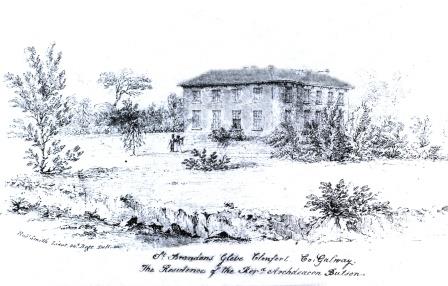
| St. Brendan's | Archdeacon Butson is listed as the occupier of the house in Glebe townland in 1855 when it was valued at £25. It is labelled St. Brendan's on both the 1st and 25-inch edition Ordnance Survey Maps. This house is no longer extant. |
|
| St. Cleran's or Issercleran | Issercleran or St.Clerans was the home of the Burke family who built the house c.1784. At the time of Griffith's Valuation it was owned by John Hardiman Burke and was valued at £45. In 1906 it was the property of Anne Maxwell (nee Burke) and was valued at £46. It was sold in the 1950s and became the home of film director, John Huston. Up until 2008 it functioned as a luxury hotel owned by the Griffin Group. |
|
| St. Ernans | John Hamilton held St. Ernans in fee at the time of Griffith’s Valuation when the building complex was valued at £46 as well as a mill valued at £28. In the later 20th century the property functioned as a hotel. The National Inventory of Architectural Heritage suggests it was built in the 1820s but extended and modified later in the nineteenth century. It is still extant. |
|
| St. Helens [Townsend Lodge] | James H. Todd was the occupier of this property at the time of Griffith’s Valuation, when it was valued at £17 10s. He was leasing it from a Kennedy lessor. The house is labelled as Townsend Lodge on the 1st edition Ordnance Survey map but as St. Helens on the 25-inch edition of the early 20th century. In 1837 Lewis had recorded this property as the seat of a Colonel Downing. Now used as a business premises. | |
| St. John's | This house was built later in the nineteenth century. It appears as "St. John's" on the 25-inch Ordnance Survey Map of the 1890s. The Corbishley family occupied St. John's until the early twentieth century when an auction was held on the premises. The property was purchased by the Finn family but members of the Corbishley family remained living in the house for some years afterwards. St. John's remained the property of the Finn family until later in the twentieth century. In 2005 it was sold. Extensive works have since been carried out at the entrance including new gates and railings. | |
| St. Johns/Roseville (Inishowen) | William Scott was leasing this property from the Norman estate at the time of Griffiths Valuation in the 1850s, when it was valued at over £11. Lewis referred to it as the seat of Miss Schoales in 1837. It is labelled Roseville on the 1st edition Ordnance Survey map but as St. Johns on the later editions. In the early 2020s it housed a restaurant known as the Red Door. | |
| St. Michael's/ Moneyteige | The house at St. Michael's is described in the Landed Estates court notice in April 1885 as "a handsome modern residence which cost £2000 to build". At the time of Griffith's Valuation, Edmund Davies held the townland of Moneyteige including a house valued at £2. Writing in 1976, Kelly noted that the house was built by a doctor named Davis, who bought the townland from the Lamberts of Castle Ellen. Part of the building is now roofless. | |
| St. Olan's | Rev. William Welland was leasing the property from William Crooke at the time of Griffith's Valuation when it was valued at over £20. It is labelled St. Olan's Rectory on the First Edition Ordnance Survey map and as St.Olan's on the 25-inch edition of the 1890s. In the early 1940s the Irish Tourist Association survey reported that it was occupied by Mr. Devlin, area engineer. The house is still extant and occupied. | |
| Stagdale Lodge | A Massy house occupied by members of the Massy family from the late 18th century. It was the home of Hugh Massy, a younger brother of George Massy of Glenwilliam Castle, at the beginning of the 19th century. Held by W. Massy in 1837, Lewis records the "fine avenue of stately beech trees". William Massy was still resident at the time of Grifffith's Valuation holding the property from Hugh Massy. In 1906 occupied by Hugh H.G. Massy and valued at £30.10 shillings. | |
| Stamer Park | A home of the Stamer family in the 18th century which was occupied by Daniel Finucane, Secretary to the Clare Grand Jury, by the beginning of the 19th century. Daniel's son Michael was resident in 1837. By 1860 Captain William Stacpoole who was elected Member of Parliament for Ennis was living in the house. The house is still extant. |
|
| Stannard's Grove | Located on the Cotter estate, this house was occupied by the Stannard family at the end of the 18th century. It was later occupied by the Adams and Smith families. Lewis records it as unoccupied and at the time of Griffith's Valuation it was held in fee by Edward Cotter. The home of William Stackpool at the beginning of the 20th century. Hajba writes that the house was reconstructed in 1924 after been blown up in 1921 by the British Crown Forces. In 1942 the Irish Tourist Association Survey noted that it had, since 1934, been owned by the Herlihy family. It is still extant. |
|
| Still View House (Cottage) | Robert Allman was leasing this property from the Earl of Shannon's estate at the time of Griffith's Valuation, when it was valued at £17 and had a mill adjacent. It is labelled Still View Cottage on the 1st edition Ordnance Survey map but an enlarged property at the site has become known as Still View House by the 1890s. A house still exists at the site. Allman was also leasing a mill, described as a flour mill on the 1st edition map. This site had expanded into an extensive woollen mill by the 1890s. Extensive industrial buildings still remain at the site. | |
| Stone Hall | John Allen was leasing this property to Phillip Somerville in 1851 when it was valued at £26. Noted by Lewis as the seat of Maj. J. Allen in 1837. The house is still extant and occupied. |
|
| Stonebrook [Stafford] Lodge | At the time of Griffith's Valuation, Stafford Lodge was leased by Mrs. Mary Stafford from the Barron estate. It was valued at £15 10s. In the 1870s the representatives of William Stafford of Stafford Lodge owned over 250 acres in the county. On the 25-inch Ordnance Survey map of the 1890s the house is named Stonebrook Lodge. There is still a house at the site. | |
| Stonehall | A house built c.1803 and situated on the Waller estate. It was occupied by the Langford family from at least the early 19th century. At the time of Griffiths Valuation, it was leased by Edward Langford from William Waller, when it had a valuation of £11. It appears to have been occupied by Robert Smyth in the early 20th century. This house is still extant and occupied. |

|
| Stonehall | The home of the O'Briens, later Stafford O'Briens, at the beginning of the 18th century and later in the possession of the Fitzgeralds. By the beginning of the 19th century the house was in the hands of the McMahon family. At the time of Griffith's Valuation James McMahon was leasing Stonehall from the Stafford O'Briens, it was valued at less than £3. Later the home of the Whites who intermarried with the McMahons. It is no longer extant. | |
| Stonehill House | Henry Busteed was leasing Stonehill House from William B. Warren and others at the time of Griffith's Valuation, when it was valued at £11 10s. A smaller house in the same townland, also owned by Warren and known as Maryville [W725608], was valued at £8. It was occupied by Robert Condron at that time. Neither of these houses are extant now. | |
| Stonehouse | In 1814 Leet records Stonehouse as the residence of Patrick Duckett. This may be the same property leased by Joseph Power from Osborne Boyce at the time of Grifith's Valuation and valued at £9. The original property does not appear to be extant. | |
| Stoneleigh | The house in Laghtphillip townland, part of the Lynch estate, was leased to James Stanley in 1855. In 1906 the house was owned by Hugh Greaney and was valued at almost £7. The house is still standing but derelict. A new house exists on the site and "Stoneleigh House" appears at the entrance gate. Writing in 1976, Kelly noted that the house was built by the Stanley family due to its salubrious site. |
|
| Stoneville | Originally a hunting lodge of the Southwell family, this house was the home of the Massy family for two centuries. In 1786 Wilson refers to it as the seat of Hugh Massey. A new front was added in 1802 by Hugh Massy. The buildings were valued at £12 in the mid 19th century and the property was located on the Southwell estate. It is still extant. |

|
| Stonewold | Edward Allingham was leasing a property at Ballyhanna from the Conolly estate at the time of Griffiths Valuation when it was valued at £20. It is labelled on both the 1st and 25-inch edition Ordnance Survey maps as Stone Wold. It was later associated with the Crawford family. Stone Wold was one of a number of properties demolished in the mid-1940s when several townlands were inundated as part of the Erne Hydro-Electric scheme. | |
| Stonewold | Edward Allingham was leasing a property at Ballyhanna from the Conolly estate at the time of Griffiths Valuation when it was valued at £20. It is labelled on both the 1st and 25-inch edition Ordnance Survey maps as Stone Wold. This house was recorded as the address of Johnston Teevan, solicitor, at the time of his death in 1872. It was one of a number of properties demolished in the mid-1940s when several townlands were inundated as part of the Erne Hydro-Electric scheme. | |
| Stormont | Storm-mount was the residence of John Cuffe Kelly esq in 1814 and of Mrs Kelly in 1837. Mrs Kelly was a sister of Francis Drew of Drewscourt. By the time of Griffith's Valuation it was occupied by Joseph Walplate who held it from Sir Richard De Burgho. The buildings were valued at £19+. A house is still extant at this location. In 2022 it was offered for sale. | |
| Stradbally | Griffith's Valuation shows that Christopher St.George had what are described as "offices" valued at £16 in the townland of Stradbally West, parish of Stradbally, barony of Dunkellin. This was the stable complex for Tyrone House and adjacent to the walled garden which was part of the estate. |
|
| Stradbally Rectory | Rev. George T. Roche was leasing this property from the Uniacke estate at the time of Griffith's Valuation, when it was valued at £20. The house is still extant. |
|
| Stradone | According to Burke’s Irish Family Records the Burrowes family were resident at Stradone from at least the mid-18th century. The architect J.B. Keane designed the 19th century house for Major Thomas Burrowes in 1828. His son Robert Burrowes was the owner and occupant in the 1850s when the rateable valuation was recorded as £67.10.0. The Burrowes were still in possession of Stradone in the early 20th century until it was burnt in June 1921. The stables and a gate lodge survive. |
|
| Straduff Lodge | Patrick Martin was leasing a property valued at £3 from the Keogh estate at Straduff, parish of Kilmactranny, at the time of Griffith's Valuation. This property appears on the 1st edition OS map as Straduff Lodge. It is no longer extant. | |
| Stranagappoge (Inishowen) | Robert Kilpatrick was leasing this property from the Alexander estate at the time of Griffith’s Valuation, in the 1850s, when it was valued at £10 10s. It is labelled Stranagapple Demesne on the 1st edition Ordnance Survey map of the 1830s but as Stranagappoge on the 25-inch edition of the early 20th century. The original buildings at the site seem to have been replaced. | |
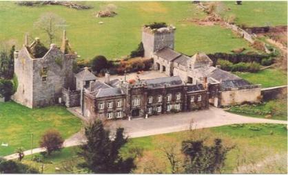
| Strancally Castle | John Keily held Strancally Castle in fee at the time of Griffith's Valuation, when it was valued at £61. Lewis refers to it as "a modern castle, seat of J. Keily" in 1837. There is a lithograph and extensive description of the castle and demesne in the sale notice of 1856. After this the castle came into the ownership of the Whitelock Lloyd family. In 1906 it owned by George W. Lloyd and valued at over £63. The 1943 ITA Survey provides a detailed description of the house from that time including the art collection and library. It is still extant and has been renovated in recent years. An extensive farmyard, valued at £37 in 1851, is located in Kilmanicholas townland at X078903. This property was valued at over £40 in 1906. |
|
| Strand House | Strand House appears to be the house also known as "Stonetown House" and marked as such on the first Ordnance Survey map. The Ordnance Survey Name Book describes Stonetown House as the seat of Daniel Gabbett and that it was built between 1760 and 1770 by G. Vandeleur at a cost of £1,100. At the time of Griffith's Valuation it was the residence of William Gabbett, valued at £44 and held from Elizabeth Vereker. Part of the original garden now occupied by The Strand Hotel. | |
| Strandhill | A 2 storey thatched house on the shore of Lough Corrib and situated opposite Ashford Castle, home of the Elwood family. In the late 18th century it was let to the Ireland family and in the mid 19th century to the Lynchs of Ballycurrin. The house was used as the home of the Widow Tolan in the film 'The Quiet Man' made in 1951 and was knocked down in the 1970s. It is associated with the recorder of Japanese folklore, Lafcadio Hearn, who spent a childhood holiday at Strandhill with his aunt Mrs Elwood. |
|
| Strandhill | At the time of Griffith's Valuation Patrick Buchan was leasing a property valued at £12 at Lecarrow or Strandhill, barony of Dromahaire, from James Fawcett. Lewis records Strand Hill as a seat of the Fawcett family in 1837. | |
| Strandhill House | At the time of Griffith's Valuation George D. Meredith was leasing Strandhill House, valued at £9, from the estate of William Phibbs. McTernan states that the house remained in the Meredith family until the 1960s. It is now a roofless ruin. | |
| Streamhill | A Crofts residence in the 18th century and in the first half of the 19th century. At the time of Griffith's Valuation it was occupied by George Crofts who held the property from Viscount Doneraile with 1619 acres. The buildings were valued at £12. Hajba writes that Edward Cavanagh Murphy built the present house in the mid 1850s. The 1890s sale notice contains a detailed description. It was sold to Langley Brasier Creagh in 1890 who made some alterations. Uninhabited at the beginning of the 21st century. |

|
| Streamsford | The house at Streamsford, parish of Killimordaly, was leased from James O'Hara to Patrick Cogovan.and valued at £10 at the time of Griffith's Valuation. It is still extant and occupied. |
|
| Streamstown | William Coghlan was living at Streamstown, near Claremorris, in 1814. In the 1830s the townland is noted as belonging to Mr. Gonne Bell of Farmhill, Claremorris. By the time of Griffith's Valuation there is no house with a significant valuation in the townland. | |
| Streamstown | The property of the Coneys family since the early 19th century, though sometimes leased to others. It was occupied by James McCreight at the time of Griffith's Valuation, when it was valued at £14. It is still extant and occupied. |
|
| Streamstown | Streamstown House was an important seat of the Irwin family in the eighteenth century. McTernan writes that it was a centre of gaiety and music and enjoyed visits from the well known harper, Arthur O'Neill. In 1786 Wilson refers to it as the seat of "Mr. Irvine". From the early nineteenth century, however, the family tended to reside elsewhere and Streamstown was usually occupied by a steward or herdsman, At the time of Griffith's Valuation, Henry Irwin was in possession of the property at Streamstown, which consisted of a herd's house and a gatehouse. It was valued at almost £2. In 1894 Slater still refers to it as a residence of Burton Irwin. Only one gable and a chimney of the house remain. | |
| Streamstown House | Streamstown House, just north of the Mullingar to Athlone greenway and marked on the first edition OS map, is a five-bay two-storey over basement country house, built c.1820 (boi). The interest of John Thomas Barlow, assignee of James Nugent, in the mansion house and lands of Streamstown were for sale in the Encumbered Estates Court on 12 February 1852. The property was held under a lease for lives for ever, the last renewal in 1846 was from William Palmer to John Thomas Barlow. At the time of Griffith’s Valuation (publ. 1854) Streamstown was the residence of Captain James H Dickson, valued at £20 and held from William Palmer. By 1906 Anne Somers was in occupation. |
|
| Streamstown House | Streamstown House, located on the eastern shore of Lough Derravargh, is a five-bay two-storey house, built about 1800. At the time of Griffith’s Valuation (publ. 1854) it was occupied by Thaddeus Lynch, valued at £11 and held from Benjamin Chapman. Michael Hope, JP and farmer, and family were resident here in 1901 and his widow Eliza and family in 1911. |
|