Browse Houses
Search Results: Returned 5927 records. Displaying results 2001 – 2100
| House name | Description | |
|---|---|---|
| Croaghan House | A small house named on the first edition six inch Ordnance Survey map (publ. 1837). The building was later extended and in the mid-1850s was occupied by the Reverend Allan, who held it from Richard Carson. It was valued at £11. David Hamill Crawford, land agent, and family were resident in the early 20th century, this building appears to be still extant. | |
| Crobeg | Home of a branch of the Stawell family throughout the 19th century. The family were involved in the flour milling business at Doneraile. At the time of Griffith's Valuation George Stawell held Crobeg from the representatives of Luke Hassard. The buildings were valued at £36. The house was demolished in the 1980s. |

|
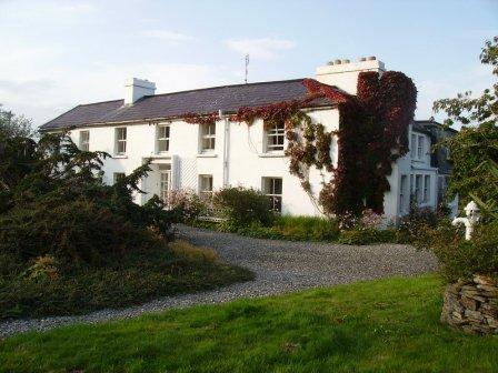
| Crocknaraw/Rockfield House | Built in the early 1850s, when it was known as Rockfield, possibly by Thomas Butler who occupied it at the time of Griffith's Valuation. It later became a Protestant boys' orphanage. In the later 20th century known as Crocknaraw Guest House and renowned for its beautiful gardens. |
|
| Croftonpark | ||
| Croftonpark | Described in the Ordnance Survey Name Books as a 'neat house', built in 1784 and occupied by Hugh Dane [Deane]. Robert Hunter lived there at the time of Griffith's Valuation and Patrick Ruane refers to the recent death of James Hunter, the owner of the house in the early 1990s. The house is still extant but no longer in use. |
|
| Croghan | At the time of Griffith's Valuation, Guy Lloyd was the occupier of the house at Croghan, valued at £40. In 1749 the Census of Elphin shows that J. Lloyd, spinster, lived there. Wilson also notes it as a seat of the Lloyd family in 1786. Croghan House is no longer extant but an extensive range of outbuildings remains. |
|
| Croghan | In 1841 the Ordnance Survey Name Books refer to "Croughane House" as the residence of Francis Drought. Michael Mullarchy was leasing it from James Fleetwood at the time of Griffith's Valuation when Croghan was valued at £15. This house is still in use as a family residence. |
|
| Croghan House (Raphoe North) | At the time of Griffiths Valuation, James Cochran was leasing this property from Joseph Scott when it was valued at £55. It was constructed after the publication of the 1st edition Ordnance Survey map of the 1830s and is labelled Croghan House on later editions. It is still extant and occupied. |
|
| Crohy House | Crohy House was occupied by Francis Foster, leasing from the Conyngham estate at the time of Griffith’s Valuation. | |
| Cromore | John Creagh leased part of Castlesaffron to Luke Hassard in the late 18th century, who Hajba writes built the house Cromore. Soon afterwards it became the home of the Campion family and Roland Campion was resident at the time of Griffith's Valuation, holding the property from the representives of Luke Hassard. The buildings were valued at £15. Later the home of the Graham family. The building was extensively rebuilt and restored in the 1980s. | |
| Cronody | In the mid 18th century Smith refers to the seat and improvements of Mr Cross at Coronody. At the time of Griffith's Valuation James Cross occupied a house valued at £10.10 shillings which he held from Viscount Midleton and John H. Colthurst. This would appear to be the house marked Crondybeg on the first Ordnance Survey map. Cronodymore was in ruins. Gillman writes that Cronodymore was inherited from Richard Hawes by the late 17th century marriage of Philip Cross to Mary Ellard, step daughter of Richard Hawes. A house and farm building are still extant at the site. | |
| Crooke Villa | Leased by Captain William Clarke from Lord Waterford's estate in 1848 when it was valued at £12. It is named as Crooke Villa on both the First Edition and later 25-inch Ordnance Survey maps. Local sources suggest this house was originally built by the local parish priest, Fr. Hearn, at the end of the eighteenth century. There is still a house at the site. | |
| Crookhaven Hotel | David Cagney was leasing a property described as a hotel to John O'Brien at the time of Griffith's Valuation. It was valued at £7 10s. Buildings are still extant at this site. | |
| Crookhaven House | At the time of Griffith's Valuation, David Cagney was leasing this property to Isaac Notter, when it was valued at £11. Lewis noted Crookhaven House as the seat of R. Doe, in 1837. This property does not appear on the 25-inch Ordnance Survey map of the 1890s. | |
| Crookstown | Smith records Mr Crook of Crookstown in 1751. The mother of Robert Warren, 1st Baronet, was Anne Crooke and this house may have got its name from her. It was the home of a branch of the Warren family from the late 18th century, occupied by the Reverend E. W. Warren in 1814, by the Reverend R. Warren in 1837 and in the early 1850s. The Reverend Robert Warren held the property in fee and the buildings were valued at £48. It was burnt in June 1921 during the War of Independence when it was the residence of Robert Warren. It is still extant and occupied. |
|
| Croom Castle | Originally a Fitzgerald Castle, subsequently granted to the Duke of Richmond who sold it to John Croker in 1721. Reverend Fitzgerald writes that Croker was agent to the Duke. A residence was built with some of the stone from the old castle. Situated on the outskirts of the town of Croom this house was occupied by Samuel A. Dickson in the mid 19th century who held it from the Crokers. The buildings were valued at £30. Sold in the late 1880s to the Lyons family and bought by Michael Corry in 1936. Now functions as self catering accommodation. see http://www.croomcastle.com/history.html |

|
| Croom House | Croom House was the home of the Lyons family in the 18th and 19th centuries. The house of James D. Lyons was valued at £48 in the early 1850s and he had a flour mill valued at £75 closeby. He held the property from John Croker. Described in 1943 by the Irish Tourist Association surveyor as a beautiful mansion on the left bank of the Maigue river, it was then in use as a military post. The house is still extant and occupied. |

|
| Cross House | Built in the early 19th century and the home of the Evans family afterwards. The walls of the house and extensive farm buildings still remain alongside some modern farm buildings. |
|
| Crossea | John O’Byrne [O’Beirne] was leasing this property from the Ecclesiastical Commissioners at the time of Griffiths Valuation in the early 1850s when it was valued at over £10. The original Valuation Office books record a valuation of £12 in 1839. The Ordnance Survey Name Books suggest the townland was in the hands of Reverend Mr. Oliver in the mid-1830s. A large farm is still extant at the site. | |
| Crosshaven House | Thomas Hayes held this property in fee at the time of Griffith's Valuation, when it was valued at £44. Lewis refers to it as the seat of T. Hayes in 1837. Local sources suggest it was built in the eighteenth century replacing an earlier house. It remainded in the ownership of the Hayes family until the early 1970s. The house is still extant and occupied and sometimes open to the public. |
|
| Crossoge | Lewis refers to Prior Lodge as the residence and property of the Reverend Dr Prior. The house in Crossoge is named Prior Lodge on the first edition Ordnance Survey map. This house appears to have been replaced by another building, a short distance to the south, known as Crossoge House sometime in the mid 19th century. Occupied and held in fee with 92 acres by the Reverend John Prior at the time of Griffith's Valuation when the buildings were valued at £25.15 shillings. This house is still in use as a country residence. [This may be the house to which Wilson, writing in 1786, refers to as"Bachelor's Lodge", in this area, which was a seat of Mr. Roe]. |
|
| Crosspatrick | The Ordnance Survey Name Books refer to the building of a house in 1832, the residence of James Knox who held the townland from Mary Boyd. At the time of Griffith's Valuation the house was occupied by William Kirkwood. Some floor tiles, which remain in the present farmyard at Crosspatrick, indicate the site of the house which no longer exists. |
|
| Crossroads (Raphoe North) | William Lockhart was leasing this property from the Earl of Wicklow's estate at the time of Griffith's Valuation in the 1850s when it was valued at £10. It has the label Crossroads on the 25-inch and later 6-inch edition Ordnance Survey maps. The National Inventory of Architectural Heritage suggests the house at the site was built later in the 19th century but it appears likely that an earlier house existed there. |
|
| Crotta House | Samuel Julian was in possession of this property at the time of Griffith's Valuation, when it was valued at £27. Lewis records it as the seat of T. Ponsonby in 1837 while Leet notes it as the residence of James O'Donnel in 1814. In 1786 Wilson writes that "Crotto" was the seat of James Carrigue Ponsonby and "very pleasantly situated with good plantations". Bary writes that Crotta had been built by the Ponsonby family and was later held on lease from the Court of Chancery by the Julian estate. At the sale of the latter estate in 1857, Crotta was described as being in the hands of the proprietor Samuel Julian. Later in the nineteenth century it was leased to the Kitchener family. Herbert Kitchener, later Earl of Khartoum, lived there as a boy. The estate was the property of the Browne family in the later nineteenth century but was offered for sale by Thomas Beale Browne in 1877. In 1894 Slater records it as the seat of Richard Savage. In the 1940s the Irish Tourist Association Survey describes it as " a ruined shell" where there was once "an imposing mansion". The remains of the house were demolished in the later twentieth century. |
|
| Crover House | This house is located on the shore of Lough Sheelin and in the mid-19th century was valued at £21.5.0. for rates. It was occupied by Thomas Cummins and held from Lord Farnham’s son, the Hon Somerset Mawell. By 1876 Robert John Cuming was resident at Crover. He owned 1,118 acres in the county. In 1901 Julia Cuming, a widow, and her daughter Kate were still resident. This house became a hotel in 1957. http://www.croverhousehotel.ie/History | |
| Crovraghan | A house situated on the Wyndham estate, occupied by John Tatlow in 1814 and J. O'Donnell in 1837. James O'Donnell held the house, valued at just over £10, from Colonel George Wyndham at the time of Griffith's Valuation. Later the home of the Cannon family until the 1970s. |
|
| Crowdrumin Lodge | At the time of Griffiths Valuation in the early 1850s Patrick Mannion was leasing this property from Samuel Galbraith’s estate when it was valued at just over £3. A more substantial property, labelled Crowdrumin Lodge, is shown on the 25-inch Ordnance Survey map of the early 20th century. It has been replaced by a modern house. | |
| Crowsnest | In 1856 Allan Pollok was the occupier and lessor of a property valued at £6 together with over 460 acres, in the townland of Crowsnest, parish of Clontuskert, barony of Longford. Molloy provides a detailed description of the huge farmyard (M868239) in the neighbouring townland of Ganaveen which was part of the Pollok estate. The latter was destroyed by fire in 1920. The Crowsnest property is now in ruins. |

|
| Croy Lodge | Occupied in the 1830s by Con O'Donel, the lodge was held by the Clives from the Marquess of Sligo. It was valued at almost £3 at the time of Griffith's Valuation. In the early 1830s Reverend William Maxwell wrote his book ''Wild Sports of the West'' at the lodge. The building is still extant but disused. | |
| Cruise Lawn | Held by William Cruise from James Galbraith at the time of Griffith's Valuation when the house was valued at £5. It is named Cruice Lawn on the 25-inch Ordnance Survey map of the 1890s. Cruice Lawn is now a ruin. | |
| Crumlin | Built in 1844, the original house was held in fee by Peter Blake and valued at 7 at the time of Griffith's Valuation. It was later altered and extended by Cecil Henry in the style of a French chateau. The house was sold to the Land Commission in 1913 and to John Costello in 1917, whose grandson renovated it and the courtyard in the early 1990s. |
|
| Crummin (Inishowen) | Robert Alexander was leasing this property from the Hart estate at the time of Griffiths Valuation in the 1850s, when it was valued at £11. The site appears to be disused now. | |
| Cuckoo Hill | In 1786 Wilson referred to a house he called "Clover-Hill", three miles from Caher, "the seat of Mr. Ryall". He may have been referring to the townland named Cuckoohill which appears on the 1st edition Ordnance Map. A house is present in this townland which is labelled Cuckoo Hill House on the 25-inch Ordnance Survey map of the 1890s. At the time of Griffith's Valuation, this property was leased to Patrick Heffernan by Abraham Riall when it was valued at over £6. A house and farm still occupy the site. | |
| Cuffe House or Camcuil | Camcuill townland was part of Peter Niddrie's estate at the time of Griffith's Valuation. The house with highest value was that of Edward Larrinan, leasing a property valued at £3 from Peter Niddrie. McTernan states that the house had originally belonged to the Brownes and later the Jones family of Fortland. In 1874 the sale notice referring to the Niddrie estate mentions Camcuill as "a comfortable dwelling house with extensive offices, recently erected". In 1906 a house in this townland is recorded as the property of the representatives of Grace Niddrie. |
|
| Cuillaun | Part of the Oranmore and Browne estate in the mid 19th century, occupied by Frenches, Brownes and by Edward Rush at the time of Griffith's Valuation, when the house was valued at £7. Now the home of the Donnellys. |
|
| Cuilleen House | A branch of the Naghten family lived at Cuilleen in the 1830s. Malachy Naghten of Cuilleen died in 1865 aged 63 and is buried in Drum Old Cemetery. The house is labelled Cuilleen House on the 1st edition Ordnance Survey map of the 1830s but is not shown on the later 25-inch edition of the 1890s and no trace is visible now. | |
| Cuilmore | At the time of Griffith's Valuation, James Powell was leasing a property valued at £7 with over 150 acres, from Lord de Freyne's estate, at Cuilmore, barony of Coolavin. The original house is not extant now. | |
| Cuiltybar | Occupied in the eighteenth and early nineteenth centuries by relatives of the O'Haras of Annaghmore. Leased in the 1830s to John Fenton Motherwell and afterwards his widow Elizabeth who held it at the time of Griffith's Valuation. It was then valued at £7 10s and leased to George Martin. It returned to members of the O'Hara family in the early twentieth century after which the land was acquried by the Land Commission. Still extant and occupied, McTernan notes that it is one of the oldest occupied houses in county Sligo and was, in the distant past, known as Trimgrove. | |
| Cuiltyconeen House | Keenehan and others state that Douglas Boyde built Cuiltyconeen House in 1847. It is recorded as having less than £3 valuation at the time of Griffith's Valuation in the mid-1850s. It was sold to the Molloy family in 1905 whose descendents continue to reside there. | |
| Culdaff House | Culdaff House was held in fee by George Young at the time of Griffith’s Valuation, in the 1850s, when it was valued at £28. Lewis also records it as the seat of the Young family in 1837, noting "the extensive and highly improved demesne". The National Inventory of Architectural Heritage suggests it was originally built in the later 18th century, possibly replacing an earlier house. In 1906 it was the property of R.G. Young and valued at almost £32. It was destroyed by fire in 1922, rebuilt and later remodelled in the mid-20th century. It is still extant and occupied. |
|
| Cullairbaun | Occupied by James Perry at the time of Griffith's Valuation. | |
| Cullane House | A house built in the 1780s, also known as Lough O'Connell. It was the home of Thomas Steele and in 1821 passed to his nephew "Honest Tom" Steele, friend of Daniel O'Connell. In the late 1840s Cullane was inherited by Tom Steele's niece who had married Charles Studdert of Newmarket House. Their son Robert Wogan Studdert held the house valued at £25 in fee at the time of Griffith's Valuation. It remained in Studdert hands until 1954 and is now a ruin. | |
| Culleen House | Culleen House is marked on the first edition OS map and had greatly expanded by the time of 25 inch, only the outbuildings remain now. O’Brien describes it as long, low seven-bay, two storey early Victorian house, purchased by Mr Mc Loughlin, a Dublin merchant, from Sir John de Blaquiere of Portloman. A Thomas McEvoy occupied Culleen in 1814. It was later sold to Godfrey Levinge, a grandson of the 4th Baronet, who was resident at the time of Griffith’s Valuation (publ. 1854), holding the house, valued at £30 in fee. Home of Thomas M Reddy and family at the time of the 1901 and 1911 censuses. This house is no longer extant. | |
| Culleenamore | At the time of Griffith's Valuation, Samuel Barrett was leasing the house at Culleenamore, barony of Carbury, from Edward Nicholson, when it was valued at £16. | |
| Cullenagh | This house, situated on the outskirts of Newcastle West, was the home of Patrick Griffin in 1814 and at the time of Griffith's Valuation. Valued at £27 it was held from the trustees of the Earl of Devon. The house remained until the mid 20th century but is no longer extant and a large industrial complex exists to the rear of the site. | |
| Cullenagh (KIlmeadan) | Mrs. Margaret Gamble was leasing this property from Viscount Doneraile's estate in 1850 when it was valued at £11 15s. A house is still extant at the site. |

|
| Cullenagh House | At the time of Griffith’s Valuation, Cullenagh House was occupied by Kean Mahony when it was valued at £22. Lewis records it as the seat of Kean Mahony in 1837 as does Leet in 1814. In 1906 it was the property of Thomas McDonagh Mahony and valued at £18. Bary states that this house was probably built by the Mahonys towards the end of the 18th century. It was still extant but uninhabited towards the end of the twentieth century. | |
| Cullenagh Lower | Myles Mahony was occupying a house at Cullenagh Lwr at the time of Griffith’s Valuation. It was valued at £6 and part of a holding of 176 acres. The house is not shown on thre 25-inch Ordnance Survey map of the 1890s. | |
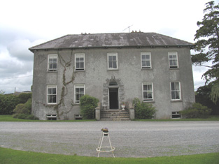
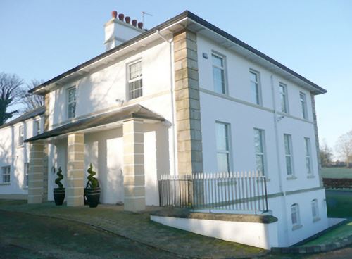
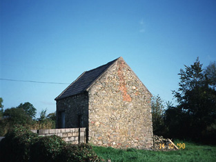
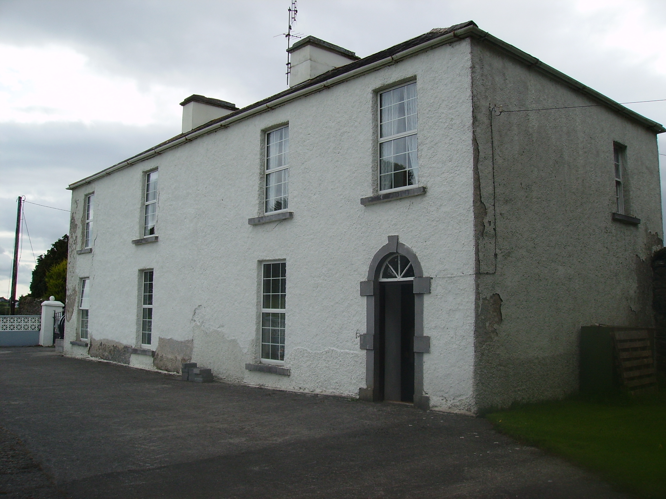
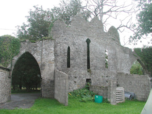
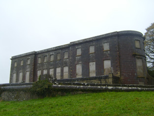
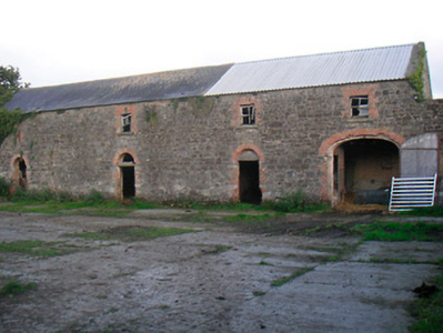
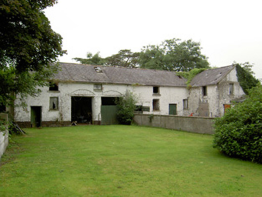
| Culliagh North [Knockmoy Abbey] | Occupied by Robert Blake Forster leasing from Martin J. Blake, at the time of Griffith's Valuation when the house was valued at £10. It is still extant and occupied. Melvin notes that it was also known as Knockmoy Abbey. |
![Photo of Culliagh North [Knockmoy Abbey]](https://landedestates.ie/storage/img/orig/2494.jpg)
|
| Cullies House | Cullies House had a rateable valuation of £35 at the time of Griffith’s Valuation and was occupied by Nathaniel Montgomery and held from Edward K. Tenison. The entrance gates, lodge and outbuildings have become part of the St Patrick’s College complex. This house was demolished circa 1980 (National Inventory of Architectural Heritage]. |
|
| Cummeen (also spelt Cummin) | The Ormsby family had a house at Cummeen, Coolera in the eighteenth century. Wilson noted it as the residence of John Ormsby in 1786, when he describes it as "a magniificent and beautiful seat". At the time of Griffith's Valuation the representatives of Charles Ormsby were leasing the house and land at Cumeen to William Phibbs who in turn leased the house to Alexander Wylie. It was valued at £13. Some building remains and a possible folly are still visible at the site. |
|
| Cummerstown House | Cummerstown House, a two-storey, three-bay house, not built at the time of the first edition OS map but named on the 25 inch. Occupied by Laurence Levey at the time of Griffith’s Valuation (publ. 1854) when the building was valued at £10.10 and held from the trustees of Wilson’s Hospital. Home of farmer Samuel O’Neill and family at the beginning of the 20th century, now the address of Cummerstown Farm Aviation Ltd. | |
| Cumry | Built post 1838, this house was valued at £10 at the time of Griffith’s Valuation and was occupied by John Mullen who held it from Lord Cremorne. A house still exists at this site. | |
| Cumry Lodge | Marked on the first edition 6 inch Ordnance Survey map, this house with a rateable valuation of £12, was occupied by the Reverend John Morell in the mid-19th century and by the Reverend James Morell in 1910 (Ulster Towns Directory 1910). The Morells were Presbyterian ministers in Ballybay, see http://treasureyourexceptions.com/morell.html The property was held from Lord Cremorne. |
|
| Curheen House | Sometimes known as Coorheen House. In 1786 Wilson refers to Curheen as the seat of Mr. Loftus. At the time of Griffith's Valuation, this was a small property occupied by Andrew Egan, leasing from the Clancarty estate and valued at £1 5s. Extended and enlarged sometime after this, by the 1890s it had become Curheen House, resided in by the Aitken family, agents for the Clancarty estate. Later the residence of the RC Bishop of Clonfert. |
|
| Curra Mill | Lady Anne Headley was leasing a property valued at £16, including a mill, to Francis Turies, at the time of Griffith's Valuation. Though it appears on the 1st edition Ordnance survey map the mill is not shown on the 25-inch editon Ordnance Survey map of the 1890s and the West Kerry branch line of the Great Southern & Western Railway is very close to the site. | |
| Curraclogh House | Mary Gibson occupied this house at the time of Griffith's Valuation. It was held from Sir Augustus Warren and was valued at £12.10 shillings. This house is no longer extant. | |
| Curragh | At the time of Griffith's Valuation John Courtenay held a house, offices and gate lodges at Curragh, valued at £28. The first Ordnance Survey map shows a farm yard for Ballyedmond in Curragh. The 25-inch map of the 1890s still indicates extensive farm buildings, together with kennels. Farm buildings remain at the site. | |
| Curragh | William John Neligan was leasing this property from the Denny estate at the time of Griffith's Valuation, when it was valued at £8 10s. Bary indicates that the house has always been occupied by merchant families from Tralee. It is still extant. | |
| Curragh | At the time of Griffith's Valuation, Thomas Davy was leasing a house, valued at £11, at Curragh, parish of Ballynakill from the Burke of Marble Hill estate. There is still a house at Curragh and some of the adjoining land is now a golf course. |
|
| Curragh House | Lady Headley’s estate was leasing a property valued at £6 5s to James Beazly at the time of Griffith’s Valuation. Bary states that the Beazlys acted as agents for the Headley estate and that Curragh House was built c.1810. The house underwent renovation in the later twentieth century. | |
| Curragh House | A house on the Stafford O'Brien estate, the residence of the Faircloth family in the 19th century, valued at £9.10 shillings at the time of Griffith's Valuation. Accidentally burnt in the early 20th century. | |
| Curraghalicky | Edward Powell was leasing this property to Edward Ellis at the time of Griffith's Valuation, when it was valued at £7 10s. The site is now occupied by substantial modern farm buildings. | |
| Curraghamoreen House | Rev. John O'Meara was leasing this property from the Villiers-Stuart estate in 1851 when it was valued at £14. The house is still extant and undergoing renovations. | |
| Curraghbinny | In 1850 Henry Smith was leasing this property from the estate of Louisa Penrose and others, when it was valued at £10. It is not shown on the 25-inch map of the 1890s. | |
| Curraghbog | Leased by Allen Pollok to Michael Kelly in the mid 1850s when it was valued at £7. A house is still extant at the site. | |
| Curraghbower | ||
| Curraghboy | This house, valued at £9, was held by Arthur Bingham at the time of Griffith's Valuation and was unoccupied. The original buildings are not shown on the 25-inch Ordnance Survey map of the 1890s. | |
| Curraghboy House | Occupied by J. Byrne or Burne in the 1830s and by Thomas W. Jefferson at the time of Griffith's Valuation and still a family residence. |
|
| Curraghbridge | Located on the Bury estate and home of a branch of the Fosbery family for much of the 18th and 19th centuries. Taylor and Skinner record the occupant as the Reverend Mr Westrop in the late 1770s. ''Burke's Irish Family Records'' records Thomas Westropp of Curraghbridge, father of the Reverend Thomas Westropp rector of Doonass. The residence of G. Fosbery in 1814 and in 1837. Described circa 1840 as in good repair and comprised of 4 storeys. Occupied by Samuel Dixon Power in the early 1850s who held the house and 197 acres from George Fosbery. It was later occupied by S.D. Power's son-in-law, Edmond Langley Hunt. A house is still extant at this site. | |
| Curraghglass | J.W. Walsh is noted as the proprietor of Curraghglass in the Ordnance Survey Name Books of 1841. In the mid 19th century Thomas Meara occupied a house valued at £11 and held from the representatives of Jonathan Walsh. There is still a building located at this site. | |
| Curraghleagh Lodge | The O'Moore sales rental of 1852 states that Isidore Bourke held Murneen North by a lease dated 1844, for 500 years. At the time of Griffith's Valuation he was leasing this property from Garret O'Moore when the house was valued at £30. This building is labelled Curraghleagh Lodge on the 25-inch Ordnance Survey map of the 1890s. A building much reduced in size is visible at the site. | |
| Curraghmore | The house at Curraghmore is centred on the old medieval tower house of the Le Poer family to which various additions and renovations have been added. Both Smith, writing in 1774 and Wilson, writing in 1786, offer detailed contemporary descriptions of the house and demesne . At the time of Griffith's Valuation, it was valued at £210. In 1906 it was valued at £200. The 1943 ITA survey describes it in detail, stating that it was one of the finest properties in Munster, if not in all of Ireland. It is still extant and occupied by the Le Poer Beresford family. See www.curraghmorehouse.ie for more information. |

|
| Curraghroe | At the time of Griffith's Valuation this property was in use as a Constabulary Barracks, valued at £5 and leased from the estate of Theobald Dillon. Local sources suggest the police were withdrawn from the barracks in the late 1860s. In modern times it has become known as Sullivan's Cross. The house is still extant and occupied and in 2014 was offered for sale. | |
| Curraglass House | Part of the Lysaght estate from the mid 18th century, W. and L. Giles are recorded at Curraglass in 1814. Earlier, in 1786, Wilson refers to it as the seat of Mr. Bonwell. By 1837 W. Gumbleton was resident and his widow Mrs Georgina Gumbleton occupied the house in the early 1850s. It was valued at £58+. Hajba writes that she was the last occupant of the house which is now demolished. | |
| Currah Chase | This was an 18th century house with early 19th additions, home of the Hunt/De Vere/ Vere O'Brien family. In 1906 it was valued at £57 and was occupied by Henrietta L. De Vere. Bought by the Forestry Department in the 1940s the house was destroyed by fire in 1949. |
|
| Currahaly | Occupied by S. Penrose in 1814, by H. Penrose in 1837 and by Joseph R. Harding in the early 1850s who held the property from John L. Westropp. It was valued at £25. | |
| Curraheen | The home of the Stephenson family for some of the 19th century. Slater's Directory of 1846 for the town of Rathkeale records Mr John Stephenson of Curraheen but no Stephenson is recorded in Curraheen South in Griffith's Valuation. |

|
| Curramore | In 1906 Herbert Sullivan is recorded as the occupier of a mansion house valued at £33.5 shillings in the townland of Knockglass. The Irish Tourist Association survey records that this house was demolished by 1944. | |
| Curramore House | Bence Jones dates this house as circa 1830. At the time of Griffith's Valuation it was occupied by Geoffrey Martyn and valued at £20. It was still in the possession of the Martyn family in the mid 1920s. Curramore is still extant and occupied. |
|
| Currans House | The Ordnance Survey Name Books record Currans House as in a "decayed condition" in 1840. It was allegedly built c.1700. Francis Peet had resided there until c.1829. At the time of Griffith's Valuation, it was in the possession of Charles Daly, unoccupied and valued at £3. It is labelled Currans House on both the 1st and 25-inch edition Ordnance Survey maps. A house is still extant at the site. | |
| Currarane | John Tresilian was leasing this property from the Earl of Bandon's estate at the time of Griffith's Valuation, when it was valued at £7. In 1814, Leet noted it as the seat of John Howe. A house is still extant at the site. | |
| Currarevagh | At the time of Griffith's Valuation, Henry Hodgson owned the townland of Currarevagh and occupied the house there, then valued at £5. The existing house was built in the mid 19th century and is still owned by the Hodgson family who run it as a guest house. |
|
| Curravarahane House/Bernard Court | William Smith Bernard was leasing this property from the Bandon estate at the time of Griffith's Valuation, when it was valued at £42. Lewis notes the residence of W.S. Bernard, as The Farm, in 1837. It was labelled Bernard Court on the 25-inch Ordnance Survey map of the 1890s. It is still extant. |

|
| Curristown | Curristown House was a property in the ownership of the Purdon Family from about 1760. The house, a two-storey, three-bay late 18th century building, was the home of George Purdon in 1814 and 1837. Valued at £21 it was unoccupied at the time of Griffith’s Valuation (publ. 1854). Augustus C Purdon was the immediate lessor. Occupied by Algernon Briscoe and family in 1901, the house remained a Briscoe home until the mid-20th century. It was demolished in the late 20th century. |
|
| Curryglass | Originally a Goold home, occupied by B. Plummer in 1814 and Pierce Purcell Goold in 1837. His representatives held the property in fee at the time of Griffith's Valuation and the house was valued at £18. It was advertised for sale in May 1852. Home of Robert Edward Gibbings for sometime in the mid 19th century. An O'Callaghan home in the 20th century. Also known as Curraghglass or Curraglass House. In 1943 the Irish Tourist Association Survey noted its association with all of these families as well as, in the eighteenth century, the Lysaght family. It is still extant and occupied. |
|
| Currygrane House | In 1837 Lewis noted “Curraghgrane” as the seat of W.L. Galbraith. At the time of Griffiths Valuation in the 1850s, William F. Ryan was leasing this property from the Misses Bond, when it was valued at £20. In 1906 it was valued at over £47 and in the ownership of James Wilson. This was the birthplace of Field Marshal Sir Henry Wilson, Britain’s chief military advisor at the end of WWI, assassinated in London in 1922. Currygrane House was burned a few weeks later and subsequently demolished. Extensive outbuildings remain at the site. |
|
| Currymount | Lewis gives J. O'Leary as the proprietor of Currymount in 1837. By the time of Griffith's Valuation Currymount was held by Alexander McCarthy in fee and was valued at £7.10 shillings. Hajba writes that Alexander McCarthy left Currymount to his brother-in-law, James Morrogh, third son of James Morrogh of the city of Cork. The house was considerably extended post Griffith's Valuation. James McCarthy of Currymount owned 259 acres in the 1870s. In the late 19th century Eustace Morrogh Bernard lived at Curraghmore. Bought by the Purcells of Burton Park in the second decade of the 20th century as a dower house and passed by marriage to the Bird family. The Irish Tourist Association Survey refers to it as the seat of Major Bird in the 1940s and also that the Morrogh-Bernard family resided here before going to live at Byblox. |

|
| Cuskinny | A French home from the early 19th century, occupied by Savage French in 1814 and by his son Savage T.W. French in 1837 and in the early 1850s. The house was then valued at £32 and held from Bartholomew Verling and Thomas R. Sarsfield. IN 1894 Slater noted it as the seat of S. French. This property was still in the possession of the descendants of the French family in the 1970s. |

|
| Cuslough | Lewis describes this house as formerly a 'seat of Lord Tyrawley and now of R.Livesay'. At the time of Griffith's Valuation it was occupied by Richard Livesay, leasing from Colonel Charles Knox, when the house was valued at £12. It stood close to the ruins of Cuslough Castle. | |
| Cutteen House | Phillip Coffey held this property from Edward Gallwey at the time of Griffith's Valuation when it was valued at almost £10. He also held an estate of over 1200 acres there. The 25-inch Ordnance Survey map of the 1890s names the property as Cutteen House. | |
| D'Loughtane | The Ronayne family were resident at D'Loughtane for many centuries. It was lost to the family in the 17th century but recovered through marriage with a Bluett. In the eighteenth century Smith refers to it as "the pleasant seat of Mr. Ronayne". The original house was destroyed by fire and a new one built in the early 19th century. At the time of Griffith's Valuation, it was held in fe by Robert P. Ronayne and valued at £26. The sale rental of June 1851 states that it was erected at a cost of £3,500. Knight writes that it was sold in the Encumbered Estates Court in 1856 to Mr Samuel Allen who sold it later to John Pedder Furlong of Fermoy. Furlong sold the property to the Land Commission in 1910. The house has had a number of occupiers since then and is now owned by the Smiddy family. |
|
| Daisybank House | In 1848, Patrick Tracy was leasing this property from the Power estate when it was valued at over £18. The National Inventory of Architectural Heritage suggests it was built in the later eighteenth century and served as a hotel during its long history. |
|
| Dalefield | Lewis records a house called Dalefield, parish of Kilkeevin, as the seat of J. Grey in 1837. At the time of Griffith's Valuation Alice Gray was leasing a property valued at £10 to Charles O'Connell. In 1814 Dalefield was the residence of Michael O'Flinn. | |
| Dalgan | Built in 1801 as the new home of the Kirwan family formerly of Claremount, Claremorris. It was bought by the Duke of Bedford in 1853 for Lady de Clifford, the wife of his first cousin. In the 1860s Henry Edward Joly and Charles Joly are recorded at Dalgan Park (''Connaught Telegraph'' 27 March 1867). In 1894 Slater noted it as the seat of Allan J. Algie. The house became a seminary for the missionary Society of St Columban in 1918. The Irish Tourist Association file describes the fine mansion as in ruins. It contained about 50 rooms and had been stripped of its roof and fittings about a year previously, circa 1944. It is now demolished. |
|
| Dalgin | In 1786 Wilson refers to "Dalygan" as the seat of Mr. Birmingham. It was held in fee by Michael Bermingham at the time of Griffith's Valuation when it was valued at £17. Inhabited by the Birminghams and later the Kirwans until 1954, subsequently demolished. Out buildings still remain at the site beside a modern bungalow, the home of Mr John Curran. |
|
| Dalysfort | At the time of Griffith's Valuation the townland of Cahernaheeny belonged to James Maitland Kirwan, a member of the Kirwan of Dalgan family. It was leased by John Fitzgerald who was occupying Dalysfort House, then valued at £5. A house still occupies the site. | |
| Dalysgrove | The Ordnance Survey Name books describe Dalysgrove as the residence of Peter Daly and in good repair. At the time of Griffith's Valuation, Francis Daly was leasing the property at Dalysgrove valued at £32 from Peter Daly. The house was in the possession of Peter F. Daly in 1906. Sold by the Dalys in 1928, the shell of the house and parts of the walled garden remains. |
|
| Dalystown | Dalystown is marked on the first edition OS map and named on the 25 inch map. It is a detached three-bay two-storey house, built in the early 19th century. Valued at £12 at the time of Griffith’s Valuation (publ. 1854), occupied by Lewis Meares and held from John Rotton. |
|