Browse Houses
Search Results: Returned 5927 records. Displaying results 2101 – 2200
| House name | Description | |
|---|---|---|
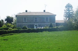
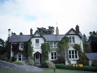
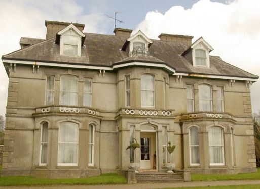
| Dalystown | Dalystown, marked on the first edition OS map and named on the 25 inch map, a three-bay two-storey house, built about 1810. It was the home of Charles Pilkington in 1837 and at the time of Griffith’s Valuation (publ. 1854). Valued at £11 the house was held from James W Berry with 189 acres. |
|
| Dalystown House | Dalystown House, marked on the first edition OS map and named on the 25 inch map. According to the Griffith’s Valuation map this was the house valued at £9 occupied by Samuel Cantrell who held it and 218 acres from James M Berry. This house was demolished. | |
| Dalystown House | Francis Tuite was leasing this property from the Thornton estate at the time of Griffiths Valuation, when it was valued at over £10. In the 1870s it was recorded as the address of Laurence Reynolds. This property is labelled Rockfield House on the 1st edition Ordnance Survey map but as Dalystown House on the 25-inch map of the early 20th century. In 1906 it was still in the ownership of Laurence Reynolds and valued at almost £23. The National Built Heritage Service suggests 1820 as a building date for the surviving farmyard complex. Dalystown House has been demolished. |
|
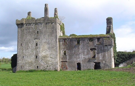
| Dalystown/Dalyston | Built for the Daly family in the mid-18th century it later became the seat of Charles O'Farrell. In 1906 it was valued at £50. It was stripped of its fittings in the early 1960s and is now a ruin. Crossbaun burial ground (M664116), located nearby, contains the mausoleum of Denis and Charlotte Bowes Daly. |
|
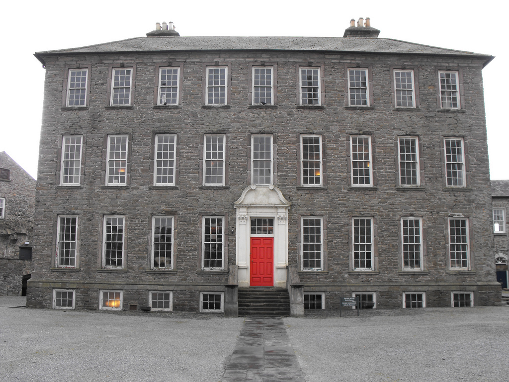
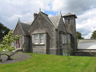
| Damer House | Located in the centre of Roscrea, this house was built by the Damer family in the early 18th century. Used as a barracks for much of the 19th century, it has also functioned as a school. Saved from demolition by the Old Roscrea Society and the Irish Georgian Society in the 1960s, it is now under the care of the Office of Public Works and the Roscrea Heritage Society. |
|
| Damer's Court | In 1837 Lewis refers to this house as follows "built about a century ago by John Damer, passed to the Earl of Dorchester and then to Lady Caroline Damer his daughter and sole heir and is now the property of the Earl of Portarlington. The mansion was taken down in 1776". It is marked on Taylor and Skinner's map. In 1786 Wilson refers to it as "the very noble and beautiful seat of Lord Milton", On the 1st edition Ordnance Survey map it is labelled "Damerville Court [in ruins]". There is no trace of this house now. | |
| Damerville | Austin Cooper Chadwick, third son of John C. Chadwick, lived at Damerville in the 1830s. In 1840 the Ordnance Survey Name Books describe it as "a modern structure in good repair". By the time of Griffith's Valuation [his widow] Mrs Anne Chadwick was resident. The house was valued at £10 and held from the Earl of Portarlington. It is still extant. |

|
| Danby (Kilbarron) | At the time of Griffiths Valuation, Patrick Brady was leasing this property from John Ffolliot and the representatives of John Hamilton. It was valued at £16. In 1837 Lewis had recorded it as the seat of J. Forbes. The National Inventory of Architectural Heritage suggests it was built in the early nineteenth century. It is still extant and was offered for sale in 2022. |
|
| Danesfield | At the time of Griffith's Valuation, George E. Burke was leasing Danesfield to Henry Daly when it was valued at over £23. The house is demolished, however the yard bell holder and the remains of the walled garden are still visible. |
|
| Danesfort | Captain James Colthurst was leasing this property to Reverend Samuel Butcher at the time of Griffith's Valuation, when it was valued at £11 10. Lewis refers to it as the seat of Captain Colthurst in 1837 "commanding interesting views of the Middle and Lower Lakes". In 1874 the Danesfort estate of Samuel Butcher was offered for sale in the Landed Estates Court. The house is described as "beautifully situated, overlooking the Bay of Castlelough". Bary notes that it was occupied up until the 1920s but is now a ruin. | |
| Danesfort | A residence of the Brown family occupied by Henry Brown in 1814, by Mrs Brown in 1837 and by Henry Brown circa 1840. John S. Brown is recorded as the occupier at the time of Griffith's Valuation, holding the property from the Honourable C.B.C.S. Wandesford. It was valued at £8. | |
| Danesfort | According to Hajba built by James Butler Stopford in the very early 19th century, replacing an earlier cottage. Stopford sold his interest to his brother-in-law, Captain Edmund Lombard a few years later. At the time of Griffith's Valuation it was occupied by the Captain's nephew, James Hunt, who held the property valued at £27.15 shillings from Christopher Crofts. In 1944 the Irish Tourist Association survey noted that it was the residence of Stopford Hunt. The house was destroyed by fire in the 1950s. | |
| Danesfort | The present house replaced that marked on the first edition six inch Ordnance Survey map (publ. 1837). Danesfort was the home of the Dean of Kilmore and is situated a short distance from Kilmore Cathedral. Mulligan refers to a Deanery House on the site in 1739. Dean Magenis was resident in 1814 and Lord Fitzgerald and Vesey, Dean of Kilmore, in the 1850s. The buildings were valued at £24 for rates. The building is still in use as the home of an ecclesiastic. |
|
| Danesfort (Inishannon) | Rev. Somers Payne was leasing this house from John Phibbs at the time of Griffith's Valuation, when it was valued at £10. Now a care facility run by Brothers of Charity services. | |
| Danesfort (Loughrea) | On the first edition Ordnance Survey map this house is labelled Lisduff House but on the 25-inch edition of the 1890s it has become known as Danesfort. In the mid 19th century it belonged to a branch of the Dolphin family of Turoe. By the early 20th century Danesfort was inherited through marriage by the Tighes of The Heath, near Ballinrobe, county Mayo and in 1906 was the property of Robert Dolphin Tighe when it was valued at almost £16. It is no longer extant. |
|
| Danesfort (Moydow) | Reverend Francis Gregg was leasing this property from the Cooke estate at the time of Griffiths Valuation when it was valued at almost £21. In 1777 Taylor and Skinner had recorded the house at "Cranny" as the property of the West family. The house is labelled Danesfort on the 25-inch Ordnance Survey map of the early 20th century. It is still extant but derelict. |
|
| Danesfort (Roscommon) | At the time of Griffith's Valuation, William Roycroft was leasing the house at Danesfort, valued at £12, from Miss M. O'Connor. In 1814 it was recorded as the seat of Gilbert Roycroft. Lewis also describes "Deansfort" as the seat of the Roycroft family in 1837. Keenehan and others state that the Roycroft house was demolished c.1890 and another house constructed on the site by the Duignan family. | |
| Danesfort House (Ballynakill) | Jethro Hemsworth was occupying the house, valued at £10, at Gortnakilla, in the 1850s. He was leasing from Henry Brunskill. There is still an extant house at the site. | |
| Dangan | The main residence of the Creagh family in the 18th and 19th centuries, held by Cornelius Creagh in fee at the time of Griffith's Valuation when the house was valued at over £25.. Sold in the 1920s, the Irish Tourist Association Survey file records the house as dilapidated and going to ruin in the 1940s. Weir writes that the house was demolished in 1948. | |
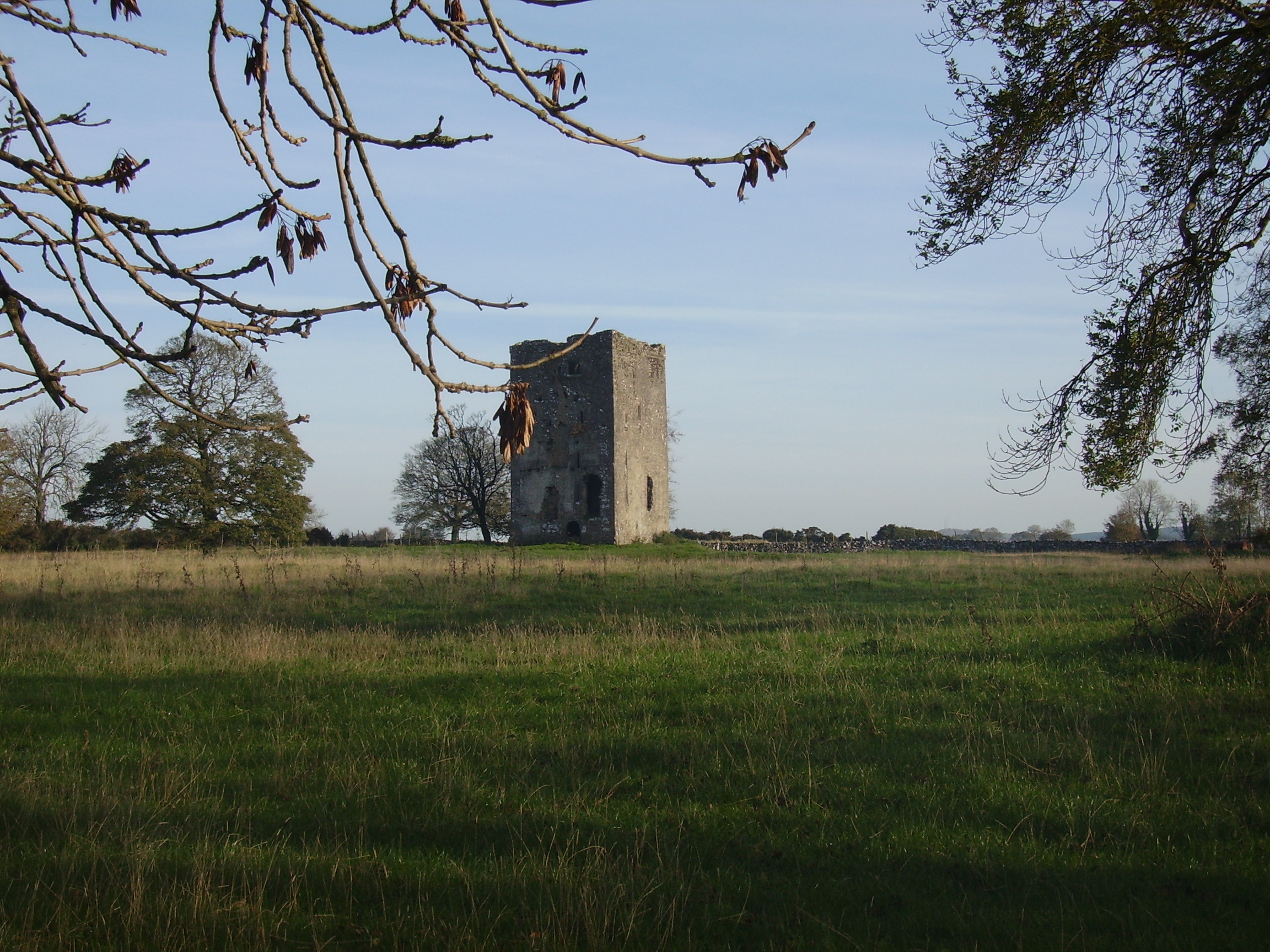
| Dangan | Dangan Castle was one of the main residences of the O'Beirne clan but was badly decayed by the early 17th century. Dangan House was built nearby and was occupied by the O'Beirne family from the 17th to the 19th centuries. They held Dangan from the King family. Father Martin Coen writes that Dangan House in the parish of Kilmore was the birthplace of George J. P. Browne, Bishop of Galway in the 1830s. Patrick O'Beirne was the occupant in 1814 and 1837. It was the residence of Mathew Hanly at the time of Griffith's Valuation when the house was valued at £8. Farm buildings exist at the site. |
|
| Dangan House | In 1786 Wilson writes that "Dangin" was the seat of Richard Martin, "beautifully situated on the banks of the fine river Corrib". Occupied by George Symmes in 1814. The Ordnance Survey Books describe it as "a 3 storey house belonging to the proprietor of the townland, Thomas Redington". It remained the home of the Redington family for most of the 19th century. The house labelled Dangan House on the 1st edition Ordnance Survey map is located very close to the bank of the River Corrib (M283277). By the 1890s it has moved to a site in closer to the centre of the townland. It is now occupied by the Cunningham family who run a garden centre at the same location. A property known as "Dangan Cottage" was located nearby (M280274) but is described as "in ruins" on the 25-inch Ordnance map of the 1890s. Kinmonth states that this property was leased by American artists, including J. Lizzie Cloud, in the 1870s. | |
| Dangananella House | Situated just outside the village of Cooraclare this house was the home of Thomas Brew in the late 18th century. In the 19th century it was a Studdert home and Thomas Studdert was resident at the time of Griffith's Valuation. He held the property from Hugh P. Hickman and it was valued at over £12. This house was for sale in 2008. |
|
| Dangansallagh | Lewis records J. Lewis as resident at Dangan Lodge in 1837 and Griffith's Valuation records James Middleton holding the lodge valued at £10+ and 266 acres in fee. It is now a ruin. | |
| Dannanstown | A house built beside a large mill by John Furlong circa mid 19th century. At the time of Griffith's Valuation occupied by John Furlong who held it and the large flour mill and offices from Richard Welstead. The buildings were valued at £135. Later owned by Humphrey Smith and Robert Hobson. |
|
| Daramona House | The National Built Heritage Service suggests this house was built c.1850 by the Wilson family. In later times there was also an observatory at the site. At the time of Griffiths Valuation, it was held in fee by William Wilson and valued at over £28. In 1906 it was owned by John Wilson and valued at almost £73. It is still extant though apparently not in use. |
|
| Dardistown | Dardistown, described by O’Brien as a two-storey, three-bay Georgian house, a Fetherstonhaugh home in the late 18th century. In 1837 Lewis records ‘Durdistown’ as the seat of Theobald Fetherstonhaugh. By the time of Griffith’s Valuation (publ. 1854) the Metge family was in possession. John Branigan held the house valued at £12 from John C ‘Medge’ Metge. The Simons family were living in a first class house at Dardistown at the beginning of the 20th century. Buildings still occupy the site. | |
| Darlington Lodge | Darlington Lodge, named on the first edition OS map, occupied by A McDonnell in 1837 and by John Malone and held from Captain H Boyd Gamble at the time of Griffith’s Valuation (publ. 1854) when valued at £18. O’Brien writes that it was possibly built as a dower house for Hallstown/Halston. The home of the Kenny family in recent times. | |
| Darragh House | The residence of Fred Bevan in the early 1850s, held by him in fee and valued at £12+. In the 1870s Hamilton Geale/Gale lived at Durragh Lodge. The house is now known as Darragh House and is still extant and occupied. Self catering accommodation is available, see www.darraghcottages.com. |

|
| Dartfield | The home of R. Blake in the 1830s. By the time of Griffith's Valuation, Dartfield was the property of Maria L. Blake and was valued at £28. Later occupied by Geoghegans, Hardys and now home to the horse museum run by the Leahy family though the house itself is largely ruinous. |
|
| Dartrey House/Dawson's Grove | Dawson Grove, later known as Dartrey House, is marked on the 1st edition 6 inch Ordnance Survey Map (1836). It was built about 1770. Lewis refers to it as a ‘noble mansion’. In 1846, the 3rd Lord Cremorne/1st Earl of Dartrey replaced this house with a large Elizabethan-Revival mansion designed by William Burn. A fire in 1856 destroyed part of the house. At the time of Griffith’s Valuation, circa 1860, the buildings were valued at £105 and still valued at the same in 1906. The family honours became extinct in 1933 following the death of the 3rd Earl and the house was demolished in 1946. |

|
| Dawstown | A house on the Putland estate in county Cork, built by Dean Davies early in the 18th century and occupied by his family until the early 19th century. In the 1940s the Irish Tourist Association Survey claimed that he had built the house following his "being turned out of Blarney Castle by the Hollow Blade Company". George Davis was resident in 1810. Occupied by Edmond Mullane in the early 1850s and valued at £12. In the 1940s it was the residence of John Turpin. The house was accidently burnt down in 1956. | |
| Deane's Lodge | In 1906 Col. Charles Deane owned a property at Knockawinna, barony of Trughancmy, valued at £6 5s. Alexander Deane was the lessor of this townland at the time of Griffith's Valuation. | |
| Debsborough | The seat of the Bayly family in the 18th and 19th centuries, occupied by successive John Bayly/Bailys and held in fee. The Ordnance Survey Name Books describe it as "a large demesnewith commodious dwelling house" in 1840. In the mid 19th century the house was valued at £38+ and in 1906 at £65. A building is still located at this site. | |
| Deel Castle | James Cuff, Lord Tyrawley, built a house beside the Old Bourke Castle in 1791. It is labelled Deel Castle on 1st edition Ordnance survey map but as Castle Gore on the later 25-inch edition The house was burnt in 1922 and not rebuilt. |
|
| Deelish House | At the time of Griffith's Valuation, Avisa Clarke was leasing this property to the Guardians of Skibbereen Poor Law Union as an auxiliary workhouse. It was then valued at £8. It is still extant and in use. |
|
| Deelish House | John Gallway was leasing this property to Henry Marmion at the time of Griffith's Valuation, when it was valued at £12. It is still extant. |
|
| Deer Park | Lewis records Park House as the property of William Trench but the residence of De La Pere A. J. Robinson. The Reverend Frederick F. Trench was the occupier in the mid 19th century, holding the house valued at £23 from Lord Dunalley. This house still functions as a residence. |

|
| Deerpark | This house valued at £34.12 shillings was occupied by John Hare and held from the representatives of - Wyse in the mid 19th century. The National Inventory of Architectural Heritage survey indicates it was built around 1850. It is still extant. |
|
| Deerpark | At the time of Griffith's Valuation, James Horsman was leasing buildings valued at £28 which included a mill, at Deerpark, parish of Kilcloony, barony of Clonmacnowen, from the Clancarty estate. The property was in ruins by the 1890s. | |
| Deerpark | Home of the Daltons for much of the 18th century. Occupied by Simon O'Donnell in 1814 and by Edward Maunsell (son of George of the Ballywilliam, county Limerick family) in 1837 and at the time of Griffith's Valuation, when it was valued at £30. Maunsell held the property from Matthew Canny. Inherited by Maunsell's fifth son Thomas. It was sold to Shannon Development in the 20th century. | |
| Deerpark (Lismore) | Arthur Ussher held in fee a farmhouse and farmyard at Deerpark, valued at £16 10s, in 1851. Extensive farm buildings still exist at the site. | |
| Deeshart | Denis Fielding held a house, office and mills valued at £28 from John H. Colthurst at the time of Griffith's Valuation. This may be the premises labelled "Carding Mill" on the 1st edition Ordnance Survey map and as "Dripsey Woollen Mills" on the 25-inch edition of the 1890s. Industrial buildings still exist at the site. | |
| Delamaine Lodge | According to O'Connell, Delamaine Lodge was occupied by a Huguenot merchant, Captain William de la Maine, in the late eighteenth century. It was later owned by the de Basterort family and afterwards by the Gregory estate. It is still extant. |
|
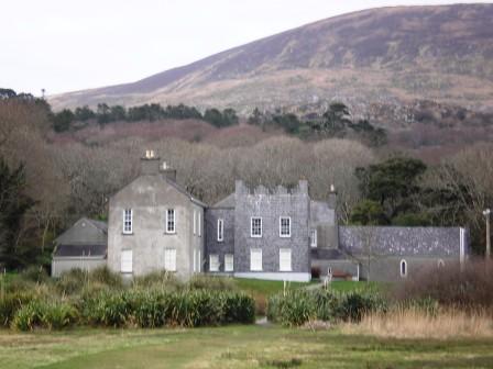
| Delphi Lodge | The house was built circa 1820 by the 2nd Marquess of Sligo, who had visited Delphi in Greece. It was leased to Thomas Spencer Lindsey of Hollymount House, county Mayo in the 1820s, to Stepney St George of Headford Castle, county Galway in the 1830s and to the Honourable Reverend William Conynham Plunket (later Archbishop of Dublin 1884-1887) in the 1850s. He was succeeded as tenant by Captain and Mrs Houstoun and other members of the Houstoun family. When the 6th Marquess of Sligo sold his estate to the Land Commission, he bought back this property and the 20th century history of Delphi Lodge is well documented in the Westport Estate Papers. The house was bought by Peter Mantle in the 1980s and is now run as a guest house specializing in fishing holidays. |
|
| Demesne (Raphoe South) | William Baird was leasing this property from the representatives of Connelly M.L. Leckey at the time of Griffith's Valuation in the 1860s, when it was valued at £10. The original building is not extant. | |
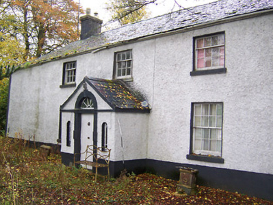
| Dennistown House | Built post 1838, occupied by Hugh Craven at the time of Griffith's Valuation and a centre for the Agricultural Institute in the late 20th century. | |
| Derk | The home of the Considine family in the 19th and 20th centuries and formerly of the Heffernan family. At the time of Griffith's Valuation the house was valued at £40 and held in fee. Bence Jones writes that this house was sold in 1971. |

|
| Dernasliggaun | A house on the shore of Killary Harbour, named after a small lough in the townland of Tullyconnor, built by Alexander C. Lambert on a farm of 250 acres leased from Colonel Alexander Thomson in 1854. | |
| Derragh | This house was the home of Denis McCartie in the first half of the 19th century. In the occupation of the Poor Law Guardians at the time of Griffith's Valuation when it was valued at £12+ and held from his widow Ellen McCartie. Later occupied by John and Mary O'Connell formerly of Ardnageeha. The house was demolished in the 1950s. | |
| Derrane House | The home of the Corr family in the 19th century, Henry Corr is recorded as living at "Durham" in 1814. Henry "Gorr" was residing in a property here valued at £12 at the time of Griffith's Valuation. It is recorded as "Derrane House [in ruins]" on the 25-inch Ordnance Survey map of the 1890s and very little trace remains of it now. | |
| Derreen | Peter McSweeney was leasing the property at Derreen from the Lansdowne estate at the time of Griffith's Valuation, when it was valued at £6 10s. Lewis also notes it as his residence in 1837. Bary states that Derreen was originally built by a branch of the O'Sullivans from whom it passed to Peter McSweeney who was married to a member of that family. It formed part of the Lansdowne estate and later came into the possession of the Petty-Fitzmaurices. In 1906 it was owned by that estate and was valued at £53 15. It was burnt in the early 1920s but rebuilt in the same style and is still extant and occupied. It is famous for its beautiful gardens. |
|
| Derreen | A Crooke family home in the 19th century, occupied by William Crooke in the early 1850s and held from William Furlong. The buildings were valued at £12.15 shillings. [This may possibly be the house known as Broomhill, a residence of the Cross family. Epenetus Cross of Broomhill made his will in 1776, see http://www.radleysofcork.bigpondhosting.com/My_Homepage_Files/Page2.html].) This house was offered for sale in 2010. |
|
| Derreennatra Manor | This house does not appear on the 1st edition Ordnance Survey map nor is it recorded in Griffith's Valuation when the surrounding property was owned by Dr. Thomas Hicks. It is labelled Derreennatra Manor on the 25-inch map of the 1890s. A house still exists at the site. | |
| Derreeny House | This property was built sometime after the 1st edition Ordnance map was published. In the 1850s Samuel Townsend held a property in fee at Derreeny, valued at £6 10s. Labelled Derreeny House on the 25-inch Ordnance Survey map, it is still extant and occupied. |
|
| Derriheen House | In 1851 Mrs. Grace Mansfield was occupying this property, which was in the hands of the Court of Chancery at the time. It was valued at £24. It is still extant and occupied. Lewis refers to it in 1837 as the seat of C. Maunsell. |
|
| Derrinvohil | This house was not built at the time of the first Ordnance Survey. It bears the name of a townland but was originally located in the townland just to the west of Derrinvohil. The townland boundary has now altered and the house is in the townland of Derrinvohil. It was built by James Jocelyn Poe in 1845. Valued at £17 at the time of Griffith's Valuation and held from the Messrs Saurin. The house continues to function as a residence. |
|
| Derroon House | Derroon House is recorded on the 1st edition OS map. At the time of Griffith's Valuation, Capt. Richard Gethin was leasing a property at Derroon from the Gore-Booth estate valued at almost £3. | |
| Derry | The home of the Gibbs family in the 18th and early 19th centuries. It was occupied by J.B. Gibbs in 1837 and by John Hassett in the early 1850s, when the buildings were valued at £11 and held from the Reverend Robert Gibbs. | |
| Derry Castle | In 1786, Wilson writes that Derry Castle was the seat of Michael Head. Lewis records Derry Castle as the seat of M.P. Head. In 1840 the Ordnance Survey Name Books describe the demesne at Derry as "chiefly composed of platation and ornamental ground. Derry House (a commodious building) is the residence of Michael Petty Head". By the time of Griffith's Valuation it was held by Francis Spaight in fee, the buildings were valued at £71. ''The Nenagh Guardian'' of 15 April 1872 report on a bad fire at Derry Castle. Spaight family members appear to be still resident in the early 20th century. The National Inventory of Architectural Heritage states that the castle is now demolished. |

|
| Derry Cottage/Drumcree Cottage | Drumcree Cottage (also known as Derry Cottage) is named on the first edition OS map. Lewis records Derry Cottage as the home of Mrs Berry in 1837. Griffith’s Valuation (publ. 1854) records Letitia C Berry (nee Smyth) as resident in a house valued at £20 and held from Robert Smyth. A building still stands on the site. | |
| Derry House (Ross) | Family records indicate the original house at Derry was bought by Bryan Townsend, son of Richard, the Cromwellian officer, in the 1680s. This house was a short distance from the current house which was built by Reverend Horatio Townsend in the early years of the nineteenth century and was held in fee by Reverend Chambre Townsend in 1851 when it was valued at £44. Earlier, in 1786, Wilson referred to Derry as a Townsend seat. It was substantially damaged when it was burnt in April 1921 during the War of Independence. . At the time it was the residence of Alexander Sullivan, a well-known barrister. In 1944 the Irish Tourist Association Survey noted that it was still derelict following the 1921 burning. The centre portion of the house and a substantial farm still exist at the site. |

|
| Derry Lodge | At the time of Griffith's Valuation, Elizabeth Sandford was leasing a house at Derry, barony of Frenchpark, valued at £6 from the French estate. The house is described in the Ordnance Survey Name books of 1837 as "a good house, two stories high and thatched". The first edition of the Ordnance Survey map indicates a mill and a building described as "site of old iron works" close to the site. A modern building is located at Derry now. | |
| Derrya | At the time of Griffiths Valuation in the early 1850s William Pollard Urquhart was leasing a herd’s house at this location from the estate of Richard Pakenham, when it was valued at almost £11. The Untenanted Demesnes survey of 1906 indicates it belonged to Hugh P. Wilson and was valued at over £10. The building is still extant but derelict. | |
| Derrya | At the time of Griffiths Valuation in the early 1850s William Pollard Urquhart was leasing a herd’s house at this location from the estate of Richard Pakenham, when it was valued at almost £11. The Valuation Office books of 1839 noted the owner as Captain William Pakenham and the valuation was £12. The Untenanted Demesnes survey of 1906 indicates it belonged to Hugh P. Wilson and was valued at over £10. The building is still extant but derelict. | |
| Derrycarne | At the time of Griffith's Valuation Derrycarne was the property of William Ormsby Gore and was valued at £30. Lewis records it as the seat of the Nisbett family in 1837. In 1906 it was in the possession of Lord Harlech (Ormsby Gore) and was valued at £33. The Ormsby Gore estate was eventually sold in 1924 and Derrycarne and about 80 acres were acquired by a Col. Kirkwood, a relative of the Kirkwood family of Woodbrook, county Roscommon. It changed hands again several times before being acquired by the Land Commission in 1952. The house was demolished shortly afterwards. | |
| Derrycassan House | John Dopping held this property in fee at the time of Griffiths Valuation in the early 1850s, when it was valued at £36. Burke suggests it had been a D’Arcy property until the marriage of Alice D’Arcy to Anthony Dopping in the 18th century. It was in the ownership of Capt. J.D.L. Hepenstal and valued at £50 in 1906. Derrycassan House was acquired by the Forestry Service. The house was demolished and some of the stone used in the construction of St. Columba’s RC church not far away. Other estate architecture remains and there are woodland walks in the estate. | |
| Derrygoony | A house associated with the milling business of Richard Allen Minnett who held the property in fee. It is mentioned by Samuel Lewis in his topographical dictionary of 1837. The buildings, which included a house, offices and flax mill, were valued at £35 in the mid-19th century. The house is named on the 25 inch Ordnance Survey map. In 1901 and 1911, the house was occupied by Patrick Connolly, a farmer and mill proprietor and his family. The site is now planted with trees. | |
| Derryhivney House/Harding Grove | Wilson may be referring to this property when he mentions the ruins of a castle at "Derryborn" and the seat of Mr. Hind. In 1814 this house was known as Harding Grove and was the seat of Jonathan Harding. It appears under this title on the 1st edition Ordnance Survey map. The Harding family also had an estate in north Tipperary. In 1846 Slater refers to "Derryhiney" as the seat of Cuthbert Fetherston. At the time of Griffith's Valuation, the house at Derryhivney was occupied by him. On the 25-inch map of the 1890s it is labelled Derryhivney House. David England Young of Ballygibbon, county Tipperary and Harding Grove, county Galway is recorded in Walfords (1910). |
|
| Derryhoyle | In 1855 the house at Derryhoylemore, parish of Lickerrig, barony of Dunkellin, was leased by Robert O'Hara to Samuel Wade. In 1906 the house at Derryhoyle was valued at £12 and was owned by Robert F. O'Hara who also owned over 100 acres of untenanted land there. A house is still extant at the site. |
|
| Derrykeel | Derrykeel was the property of the Barry family in the nineteenth century. At the time of Griffith's Valuation it was the property of Smith Barry. There was a house on the property valued at 10s as well as 500 acres. | |
| Derryknockane | George Gloster held this house in fee at the time of Griffith's Valuation when the buildings were valued at £20. | |
| Derrylahan House | This house was the home of the Mason family in the 19th century, occupied by James Mason in 1814 and by William Mason in the early 1850s. The buildings were valued at £10 and held from Peter D. La Touche. William Mason of Derrylahan owned 228 acres in the 1870s. A house and farm are still extant at the site. | |
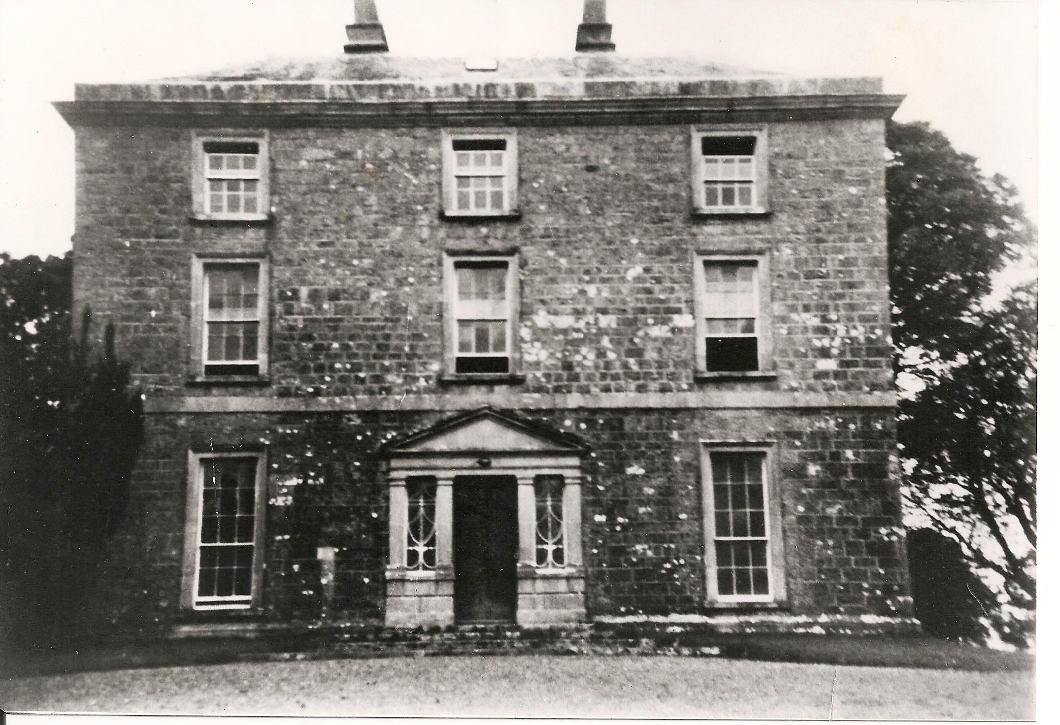
| Derrylahan Park | Bence Jones writes that this house was built in 1862 at a cost of £15,000 to the design of Sir Thomas Newenham Deane. It was the home of William Henry Head, valued at £50.10 shillings in 1906. It was burnt in 1921. |

|
| Derrylavan | A small building was located at this site on the 1st edition 6 inch Ordnance Survey Map (1836). The buildings were valued at £16 circa 1860 when William Lane was resident. He held 218 acres, about half the townland from Evelyn P. Shirley. Lough Fea was nearby. There was a milling complex a short distance away in the same townland. This house appears to be still extant. | |
| Derryleigh House | Lewis records G. Ryan as resident at Derryleagh Castle in 1837. In 1840 and at the time of Griffith's Valuation Henry Hawkshaw held a house valued at £12+ from Lady Waller at Derryleigh. A building is still located at this site. The Ordnance Survey Name Books record the existence of an old castle in this townland which had been "razed to the ground by Mr. Hawkshaw" some time previously. | |
| Derryluskan | The Pallisers were resident at Derryluskan from at least the mid 18th century. John Palliser was the proprietor in 1814 and Mrs Palliser in 1837. Their son Colonel Wray Palliser was the occupant at the time of Griffith's Valuation. He held the property from Colonel Gore and the buildings were valued at £45.17 shillings and held with a demesne of 682 acres. The Pallisers were still residing at Derryluskan in the 1870s. The house has been greatly reduced in size but still functions as a residence. |
|
| Derrymaclaughna | A house appears to be located near the castle on the first Ordnance Survey map of 1838. The Ordnance Survey Name Books mention the ruins of a castle, a mansion house and a chapel in the townland. The property belonged to the Burke family in the 18th century as Wilson noted it as the seat of Mr. Burke in 1786. It became the residence of Thomas P. O'Flahertie of the Lemonfield family in the early 19th century. He was married to a daughter of Ulick Burke of Derrymaclaughna. At the time of Griffith's Valuation it was occupied by Thomas Cullinane who held it from James Browne. Derrymaclaughna was the residence of Alan Parker Close in the 1870s. In November 1887, Richard Rowland was offering for sale a quarter share of the lands at Errew, county Mayo, as well as lands at Derrymacloughna, barony of Clare, county Galway, in the Land Judges' Court. However, due to absence of bidding, the sale was adjourned. |
|
| Derrymore | The MacGraths had a 17th century home here which was incorporated into the servants' quarters when the Gores built their 18th century mansion. They continued to occupy the house until the early 20th century. The 17th century house and servants' quarters still stand but the rest of the house has been demolished. Some of the stone and stone features from Derrymore were taken to build a house near Drewsborough on the outskirts of Scarriff, Discovery Map 58, R637 836. | |
| Derrymore | Derrymore House is described by O’Brien as a two-storey, five-bay house mid-18th century building. It is named on both the earliest OS 6 inch and 25 inch maps. In 1814 it was the home of Captain Daly and in 1837 Lewis describes it as the property of T J Fetherston Haugh of Bracklyn Castle. Still in Fetherstonhaugh possession at the time of Griffith’s Valuation (publ. 1854), it was occupied by Luke Nolan and valued at £15.10. The Nolan family were still resident at the beginning of the 20th century. The house is now a ruin. | |
| Derrynane Abbey | Maurice O’Connell was leasing the property at Darrynane More from the Earl of Cork’s estate at the time of Griffith’s Valuation when it was valued at £40. Lewis records it as the seat of Daniel O’Connell, MP. In 1814 Leet notes it as the seat of Maurice O'Connell. in 1906 it was owned by Daniel O'Connell and valued at £35 15s. The Irish Tourist Association Survey gives a detailed description of what it refers to as "the relics of the Liberator" which were kept in the house in the early 1940s. At that time the occupant was Miss Fanny O'Connell, great-grand-daughter of Daniel O'Connell. Bary states that the present house is an extended wing of the original house, built in the mid-18th century, most of which is now gone. The property is now in the care of the Office of Public Works and open to the public during the summer. |
|
| Derryowen | A home of a branch of the Lopdell family in the 19th century held in fee and of their descendants the Blaquieres in the late 19th and 20th centuries. In July 1889 the notice announcing its proposed sale in the Land Judges' Court describes it as "a very good newly-built dwelling-house, with suitable out-offices". There is still an occupied house at the site. | |
| Derryquin | ||
| Derryquin Castle | At the time of Griffith’s Valuation James F. Bland was leasing a property valued at £29 at Derryquin, from the Guinness estate. Lewis, in 1837, and Leet, in 1814, record the house as the seat of Francis C. Bland . The property was eventually sold by the Blands to the Warden family. In 1906 it was owned by Col. Charles W. Warden and valued at £70. The Wardens resided there until it was burnt in 1922. It was located in the grounds of what is now the Parknasilla Hotel but the ruins were demolished in 1969. See www.parknasillahotel.ie for e-book on the history of this property. |

|
| Derryvale | A Smith home, occupied by William Smith in 1837. The Ordnance Survey Name Books mention "Mr. White" in connection with Derryvale. John S. Smith was the occupier in the mid 19th century when the buildings were valued at £11.15 shillings and held from Richard Cathcart. Occupied by Sidney E. Smith in 1906. Derryvale is still extant. |
|
| Derryvally | An early 19th century house on the Leslie estate, occupied by Thomas McCullagh, held from Emily Leslie and valued at £16 in Griffith’s Valuation. It was located near a Presbyterian complex comprised of two churches and a school. The house continues to be a residence. |
|
| Derrywillan House | A gate lodge and caretaker's house belonging to this estate were located in the townland of Redpark while the main house was in the townland of Tynagh. In 1837 Lewis records Derrywilliam House as the seat of H. Kilkelly. Taylor and Skinner record Dirry as the seat of the French family in 1783. | |
| dfs | ||
| Dicksgrove | Richard Meredith was the owner of this property at the time of Griffith's Valuation, when it was valued at £30 15s. In 1786 Wilson notes Dick's Grove as the seat of Mr. Meredith. Both Leet in 1814, and Lewis, in 1837, refer to it as the seat of the Meredith family. In 1906 it was still owned by the Merediths and valued at £31 5s. Bary writes that this land, granted to the Herberts in the seventeenth century, passed to the Merediths through marriage some time later. The house was built sometime in the 1730s and remained in the Meredith family for 200 years, though Lyons notes that it was offered for sale but later withdrawn in 1855. The sale notice includes a lithograph of the house The estate was sold to the tenants in the 1930s. Dicksgrove was completely demolished but some of the stable buildings and gate lodges remain. |
|
| Dirk Lodge | Alexander Crichton's address is given as Dirk Lodge, Drumard, in 1870s Landowners Listings. In the 1850s the house is described as a "steward's house" valued at £8. In 1906 he was the owner of a house valued at £8 at Derk Beg, barony of Tireragh. McTernan notes that this property had been a herd's house in the early ineteenth century but was enlarged in the 1880s. It is still extant and occupied. |
|
| Distillery House | Richard Allman was leasing this property and the adjacent distillery from the Earl of Shannon's estate at the time of Griffith's Valuation. The properties were valued at £200. Distillery House is labelled on the 25-inch map of the 1890s. The distillery is labelled Allman's Distillery on the 1st edition Ordnance Survey map but as Bandon Distillery on the 25-inch edition of the 1890s. It is still extant and serves as a public house. |
|
| Doe Castle (KIlmacrenan) | Alexander Maddison was leasing Doe Castle from the Hart estate at the time of Griffith’s Valuation in the 1850s, when it was valued at £21 15s. In 1837 Lewis recorded it as the seat of the Hart family but formerly in the possession of the Sandfords. The original tower house at the site, still extant, was the seat of the McSweeney clan in the medieval and early modern period. This site is now in the care of the Office of Public Works. |
|
| Dollas Upper | Mary Blake occupied a house valued at £12+ and 48 acres on the Langford estate at the time of Griffith's Valuation. This property is labelled Dollas House on the Ordnance Survey map published in 1942. Unroofed buildings are still extant at the site. | |
| Donaghmore House (Raphoe) | At the time of Griffiths Valuation in the 1850s this property was held in fee by Reverend Charles Irving [Irvine] when the buildings were valued at £70. An "unfinished house"at the site was valued at £10. This may the house currently at the site, now known as Donaghmore House. The National Inventory of Architectural Heritage suggests it ceased to be used as a Church of Ireland rectory later in the nineteenth century. It was occupied by the Humphreys family in the early twentieth century. It is still extant and occupied. |
|
| Donaghmoyne | Donaghmoyne House is named on the 1st edition 6 inch Ordnance Survey map (1836) and the grounds include a walled garden and plantations. A mill and quarry were located nearby. Lewis records Donaghmoyne as the residence of J. Bashford. John Dixie, who had oil and flax mills near the house, was the occupier in the mid-19th century. He held the property, described as a steward’s house, from the Reverend Robin L. Tottenham, whose estate was at that time in the Court of Chancery. The buildings which included a gate lodge were valued at £17. Donaghmoyne was purchased by Richard Bolton from the Reverend Tottenham in the early 1860s. John Marshall Bolton and his wife were resident in the early 20th century. This house is still a residence. |
|
| Donegal | John O'Halloran occupied Donegal House in the mid 19th century which he held from Arthur Riall. The buildings were valued at £12.18 shillings. This house no longer exists but a farm complex is still located at the site. | |
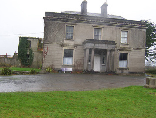
| Doneraile Court | A house of mainly early 18th century origin with 19th century additions located beside the village of Doneraile. Wilson, writing in 1786, describes it as "the magnificent and beautiful mansion, with extensive parks, gardens and demesnes". At the time of Griffith's Valuation the house was valued at £140. In 1942 the Irish Tourist Association Survey stated that the property had been bought by William St. Leger from Sir Walter Welmond and John Spenser, sonf of the poet Edmund Spenser. It was unoccupied in the 1940s and the agent was Mr. Hamilton. The house was sold to the Land Commission in 1969 by the wife of the 7th Viscount. The building was first restored by the Irish Georgian Society and since the early 1990s by various State bodies. It and the 400 acre demesne are now under the care of the Office of Public Works. |

|
| Donnybrook | Donnybrook was occupied by Charles Smyth in 1814 and by W. Hill in 1837. It belonged to the representatives of Arundel Hill in the early 1850s when the buildings were valueda at £28 and the property was held from William Hill. Bought by the O'Connors at the end of the 19th century. |
|
| Donnybrook | This house was the seat of a branch of the Poe family in the 18th and 19th centuries. William Poe was resident in 1814 and Lewis records him as the proprietor but the house was occupied by a tenant. The Ordnance Survey Name Books mention William Jackson as the occupier and describe the house as "large and commodious". At the time of Griffith's Valuation William Poe held the property in fee, the buildings were valued at £16.14 shillings. Donnybrook is still extant. |
|
| Donore House | Donore overlooking Lough Derravaragh, named on the first edition OS map. The Nugents were settled here from the 16th century. Donore House was a three-storey late 18th century Georgian block. James Nugent of Donore was created a baronet in 1768. When his brother Peter the second baronet died in 1797, Donore passed to the family of their sister Catherine who had married Pierce Fitzgerald of Baltinoran. They had two sons Thomas who inherited Donore and Lattin who inherited Soho House. In 1831 Thomas’ son Percy Fitzgerald Nugent was created a baronet and was MP for Westmeath 1847-1852. He was resident at the time of Griffith’s Valuation (publ. 1854) when the house was valued at £80. The Nugents were still resident in the early 20th century. O’Brien writes that the house was given to the Franciscan Community of Multyfarnham from whom it was purchased by the Land Commission. The house fell into disrepair and was demolished in the 1960s. | |
| Doobeg | At the time of Griffith's Valuation the property at Doobeg consisted of a herd's house, valued at over £1, together with over 300 acres, and was in the ownership of Robert McAlpine. In the later nineteenth century it was lived in by the Phibbs family. Doobeg house is still extant and occupied as a family home. |