Browse Houses
Search Results: Returned 5927 records. Displaying results 2401 – 2500
| House name | Description | |
|---|---|---|
| Earlsfield | Earlsfield had earlier been a Dodwell property. At the time of Griffith's Valuation it was leased from the Gore-Booth estate by Capt. Richard Gethin and was valued at £20. Slater records it as the seat of Francis Gethin in 1894. It is still extant and has served as a convent for many years. |
|
| Earlstown | In 1786 Wilson refers to "Capasell" s the seat of Mr. Devenish [?]. The house at this location is labelled Earlstown on the 1st edition Ordnance Survey map. In 1846 Slater refers to Robert Grace resident at Earlston. Robert Eyre was leasing a property in the townland of Cappasallagh, parish of Kilmalinogue, barony of Longford, valued at £11 from the Clanricarde estate in 1856. There are still occupied buildings at this site, the focus of a large farming enterprise. |
|
| Earlsvale | A house built circa 1840s on the estate of Earl Annesley and occupied by Captain Francis Meik at the time of Griffith’s Valuation, when the buildings were valued at £18. This may have been the residence of the agent of Earl Annesley. | |
| East Grove | Bence Jones writes that this early 19th century house was built by Dorcas Bousfield, daughter of William Bagwell and his wife Jane Harper. After her death it was inherited by the Bagwells and remained in their possession until the mid 20th century. In 1837 John Bagwell is recorded as the proprietor of East Grove and also in the early 1850s, when the property was valued at £40 and held from the representatives of Viscount Midleton. In 1942 the Irish Tourist Association Survey noted that it was the residence of Major Bagwell and the adjacent grounds contained the remains of buildings thought to be "the now-unknown castle of Ballinakilla". 20th century owners included Lorretta Brennan Glucksman, and the Kelly family, musicians. In recent years it has been offered for sale. |

|
| Easthill House | Detached three-bay early nineteenth-century Regency villa, built in 1803. This house was originally built by a branch of the Handcock-Temple family of nearby Waterstown House and by 1814 was the home of Richard Cuppaidge, who is also recorded in 1837 as the occupant. John Cuppaidge was resident at the time of Griffith’s Valuation. The house was the property of the Clynes, Dolan and O’Shea families in the 20th century. |
|
| Eastly Cottage | This house was the home of Mary Anne Lombard in the mid 19th century. She held the property from the Earl of Listowel and it was valued at £20. Hajba writes that the kennels for the Duhallow Foxhounds were later located close to the cottage. Derelict for a number of years the building has been restored and was functioning as a pub in the early 21st century. | |
| Easton House | In 1851 Jane Smyth was leasing this property from the Bishop of Cork's estate when it was valued at £13 15s. | |
| Eastwell | In 1837 Lewis records Eastwell as the seat of C. Usher. At the time of Griffith's Valuation it was occupied by Christopher Usher and the buildings were valued at £79. By 1906 it was in the ownership of William A. Usher and was valued at £81. This house is no longer extant but extensive remains of stables, demesne and walled garden survive. |
|
| Eastwood | Lewis records Thomas Bennett as the proprietor of Eastwood. James Mason held Eastwood House and 209 acres from Thomas Bennett at the time of Griffith's Valuation. The buildings were valued at £22+. Buildings are still located at this site. | |
| Ebor Hall | A house built before Griffith's Valuation by Deputy Commissary General Booth on land leased from the Provost and Fellows of Trinity College, Dublin. Booth later sold his interest to Lord Mountmorres who was murdered nearby in 1880. In 1885 Walford refers to it as the seat of Joseph Skerrett Blake. It belonged to the Boyd family for much of the 20th century. Extensively renovated in the late 20th century, it is now a well maintained residence on the shore of Lough Corrib. |
|
| Eden Hill | Situated on the Longfield estate and occupied by John Crosbie who held the house valued at £19.10 shillings from Joseph Carpenter. The Carpenter resided here from the late 18th century. Thomas Carmichael bought Carpenter's interest and advertised the sale of Eden Hill house and demesne in December 1856. Later the home of the Guerin family and in the late 20th century of the O'Callaghan family. |

|
| Eden House | Eden House was built later in the nineteenth century. In the 1870s it was recorded as the residence of Galbraith Hamilton. A will and probate grant in the Public Record Office of Northern Ireland refers to George Hamilton of Eden in 1862. It is still extant and occupied. | |
| Eden Park | Occupied by Joseph Brown at the time of Griffith's Valuation, when the property was valued at £3. Brown was leasing from Francis O'Malley. Mulloy writes that nothing remains of the house. | |
| Eden Vale | William Stacpoole moved from Annagh to Eden Vale in 1776 and this house continued to be the main Stacpoole residence until it was sold to the Clare Board of Health in the 1920s. In 1786 Wilson refers to it as the seat of William Stacpoole. At the time of Griffith's Valuation it was occupied by Richard J. Stacpoole and valued at £50. The house was a tuberculosis sanatorium in the 1940s. It is still extant. |

|
| Edenmore House | John Cochrane was holding this property in fee at the time of Griffiths Valuation when it was valued at £28. In 1906 it was also owned by John Cochrane and valued at £26. The National Inventory of Architectural Heritage suggests it was built c.1790 and offers a detailed outline of its occupancy. It is still extant. |
|
| Edgecliff House | James K. Jenkins was leasing this property from Lord Kingsale's estate at the time of Griffith's Valuation, when it was valued at £7 5s. It is labelled Edgecliff House on the 25-inch Ordnance Map published in the 1890s. This house no longer exists. | |
| Edgeworthstown House | The Edgeworth family had been settled at Edgeworthstown in the parish of Mostrim, County Longford, since the 17th century. At the time of Griffiths Valuation in the 1850s, Fanny Edgeworth was leasing the property from Charles Edgeworth, when it was valued at £45. [It is likely that Fanny was his stepmother} The National Built Heritage Service suggests the present building began in 1725 but had several rounds of modifications subsequently. In more recent years it has served as a health care facility. |
|
| Edmondstown | Edmondstown named on both the first six inch and 25 inch OS maps. At the time of Griffith’s Valuation (publ. 1854) Richard W Reynell was the occupier, holding the house valued at £10 from the representatives of Marcus Sinnott. Buildings remain at the site. | |
| Edmondstown | In 1786 Wilson refers to Edmondstown as "the fine seat of Mr. Costello". At the time of Griffith's Valuation the original house was occupied by Charles Costello. Another house was built in 1864 and it is now the home of the Bishop of Achonry and is situated in county Roscommon. |
|
| Edward's Lodge | The 1st edition OS map shows a house called Edward's Lodge, at Derrylahan, barony of Leitrim, county Galway. This appears to be the property, valued at over £1, leased by the Aylward estate to Patrick Mohan at the time of Griffith's Valuation. There are not buildings at the site now and the area is heavily forested. | |
| Edwardstown | Edwardstown was the residence of John Russell in the early 1850s held by him in fee and the buildings were valued at £18+. |

|
| Egmont Cottage | Egmont Cottage is marked on the first Ordnance Survey map circa 1840. It was the single storied residence of Margaret Magrath in the early 1850s. She held the property from the Earl of Egmont and the buildings were valued at £10. The building has since been extended and is still occupied. Hajba calls this house Egmont Lodge. |
|
| Egmont House | An early Perceval house situated at Egmont was replaced by the present house in the 18th century. At the time of Griffith's Valuation John Bolster was occupying Egmont House on the Egmont estate. The buildings were valued at £15. Later leased to the Lynch family. The house is extant and under refurbishment in recent years. |

|
| Egmont Lodge | A house was in existence at this location at the time of the first Ordnance Survey but is not named on the map. By the time of Griffith's Valuation it was valued at £14 and occupied by Bartholomew W. Purdon. It is labelled Egmont Lodge on the 25-inch Ordnance Survey map of the 1890s. A house is still extant at the site. |

|
| Egmont Villa | A house occupied by Neptune Blood in the mid 19th century. He held the house valued at £19 from Sir Edward Tierney. Restored in the 1980s by Patrick Callaghan and still extant. | |
| Eighter | On the first edition six inch Ordnance Survey map (publ. 1837) Eighter House, part of the estate of the Marquess of Headfort, is shown as set in a small demesne close to the shore of Lough Ramor. Henry Sargent was the occupier in the mid-19th century when the buildings were valued at £16. In the 1870s Eighter was the home of John Alexander Johnston, who owned 111 acres in the county in 1876. He was medical doctor and his wife had a connection with the Sargent family. Home of Michael M’Enroe in the 1920s. It appears to be extant. References to Eighter in the Small Private Collections of Cavan Library's Archives Service, P017/0084, P017/0104, P017/0125 & P017/0166. | |
| Eldon Lodge | Robert Corscadden's address is given as Eldon Lodge, Manorhamilton, in 1878. | |
| Elgin Cottage | In 1851 this property was leased by Georgiana Gumbleton to Edmund Barry when it was valued at £10. It was built after the 1st edition Ordnance map and is labelled Elgin Cottage on the 25-inch edition of the 1890s. There is still an extant house at the site. | |
| Ellaghmore | Occupied by Edmund Howley in 1814 and by E. Howley in the 1830s. A house valued at £2.10 shillings was occupied by Bartholomew Higgins at the time of Griffith's Valuation. It is no longer extant. | |
| Ellen Ville | This appears to be the house known as Broomhill which was a Radley residence. The house is named Ellen Ville on the first Ordnance Survey map. At the time of Griffith's Valuation Dr Thomas Godfrey was occupying Ellen Ville, valued at £14.15 shillings and held from William Furlong. | |
| Ellenville or Ardaghowen | The first edition OS Map suggests the house on this site was known at that time as Ellenville. It is now known as Ardaghown, still extant but derelict and was under renovation in 2006. McTernan indicates that it was originally built as a dower house for the Wynne estate. In the 1850s it was held by Owen Wynne from Capt. James Martin and valued at £35. |
|
| Ellesmere | Harloe Powell was leasing a house valued at £18 at Ardcarn, barony of Boyle, from Viscount Lorton's estate, at the time of Griffith's Valuation. This house is still extant and occupied. |
|
| Ellistron Castle | A Browne castle, a house is marked close by as the residence of the Brownes in the 1770s. In 1786 Wilson refers to Ellistron as the seat of Mr. Browne. However there is no house at this location on the 1838 Ordnance Survey map but an avenue is shown there. | |
| Elm Hall | Lewis records Elm Hall as the residence of Peter Burke while the Ordnance Survey Name Books refer to it as that of "Counsellor Burke". By the time of Griffith's Valuation his son Joseph Burke was the occupier, holding the property in fee, the house was valued at £10. A farm building now occupies the site of Elm Hall. |
|
| Elm Hill | An 18th century house the home of a branch of the Studdert family held from Lord Southwell. Occupied by Ion Studdert in the mid 19th century when the buildings were valued at £27. It was advertised for sale in June 1855 when it contained a "spacious and lofty parlour, drawing room and hall; nine capital bedrooms..". A lithograph of the house is included with the rental. In 1906 this house, valued at £16, was occupied by the representative of Thomas Magner. In the later twenteth century owned by the Woulfe family and now derelict. |
|
| Elm Hill House | A home of the Bourchier family in the 18th century. The Bourchiers intermarried with the Massys. The house was located on the Massy estate. Mrs Davis was resident at Elm Hill in 1837 and Joseph Wallplate in the mid 1850s when the house was valued at £12. The home of the Heffernan family in the latter part of the 19th century. The house is still occupied. | |
| Elm Hill House | The Ordnance Survey Name Books record William Middleton as the occupier of Elm Hill House in 1839 and mention the surroundings as "a very pretty demesne situated in a beautiful locality". At the time of Griffith's Valuation, William Middleton was leasing this property from the Poe estate when the house was valued at almost £8. The original house is no longer extant and a modern house has been constructed at the site. | |
| Elm Park | The records suggest that this house was built post 1814 and pre 1837 though there may have been an earlier property as Wilson refers to "Elm" as the seat of General Massey in 1786. Bence Jones writes that it was an early 19th century house. It was the home of the Massey family, Barons Clarina, in the 19th century. The buildings were valued at £90 at the time of Griffith's Valuation and in 1906. Bought by Patrick King in 1925 and home of the King family until 1956, now demolished. |

|
| Elm Park | Garyhasty was described by Smith in 1750 as the "pleasant country house" of Mr Riggs Faulkner. I A house located on the Riggs Falkiner estate, Wilson notes it as the seat of Rev. Mr. Kenney in 1786. It was occupied by Valentine Barry in 1837 and by Thomas Barry at the time of Griffith's Valuation and valued at £36. Home of Richard Ashe Orpen in the 1870s. Elm Park is still extant and occupied. |
|
| Elmglyn | Elmglyn was the residence of T. Gollock in 1837 and of Patrick Daly at the time of Griffith's Valuation. He held the property from the representatives of Thomas Gollock and the buildings were valued at £11. The original house is not extant. | |
| Elmhall | Built by Gerald Cuff early in the 18th century, it was let to the Jordans of Murrisk in the 1770s and to a branch of the Browne family of Westport from the 1780s until the early 19th century. In 1786 Wilson refers to it as a seat of the Rt.Hon. James Cuffe. In 1837 the 1st edition Ordnance Survey map notes that it was 'in ruins'. The Irish Tourist Association File states that Elmhall is said to have been burnt in 1798. Only some fragments of walls remain at the site. |
|
| Elmhill | Occupied by Edward Rochfort in 1814. By the time of Griffith's Valuation there was no house with a valuation of more than £1.18 shillings in the townland. The 25-inch map of the 1890s shows a later building called Elmhill House slightly north of the original building. There is still an extant house at the site. |
|
| Elmvale | Elmvale was occupied in 1814 by Henry Lysaght and by 1837 was in the occupation of J. Duggan. Arthur Duggan held the property from the Earl of Limerick in the early 1850s. The house was valued at £20. Hajba writes that in the early 20th century the house was purchased by Sidney Royse Lysaght and following a feud with a neighbour was burnt in 1917. Later rebuilt and still occupied. |

|
| Elmvale | Originally an O'Hogan home which passed to the O'Briens through the marriage of Eleanor O'Hogan and Turlough O'Brien. Their son married Margaret Long. She married secondly Cornelius O'Brien of Birchfield. At the time of Griffith's Valuation the house valued at £15 was occupied by John O'Brien who held it from Sir Lucius O'Brien. Weir writes that the house was demolished circa 1965. In 1778 and 1786 this house, known as Cross, was occupied by a Lysaght. | |
| Elsinore | At the time of Griffith's Valuation, Edward Cooper owned a property at Rosses Upper, barony of Carbury, valued at £16. In 1906 the representatives of William Middleton held a property here valued at £18 as well as over 350 acres of untenanted land. The property also has associations with W.B. Yeats who used to spend holidays here with the Middleton family. The house is now a ruin. |
|
| Elton | In 1786 Wilson notes Elton as the seat of Mr.Grady. Leet records the Reverend Thomas Grady [of Cappercullen] as the occupier of Elton in 1814. Mrs Grady lived at Elton in 1837 and Mrs Mary Jane Grady was resident at the time of Griffith's Valuation. She held the property in fee. The buildings were valued at £34. Described in the rental of 1853 as having a "cheerful and commanding aspect". The tenant from year to year was John Simms. In the later part of the 19th century this house belonged to the Bevans of Camas. The original house is not extant. | |
| Elysium | This house is marked on the first edition Ordnance Survey map and was inhabited by Thomas Ely in 1837. Thomas Ely held the property in fee at the time of Griffith's Valuation when the house was valued at £23. The Elys were still resident in the 1870s. George Evans was occupying this house in 1906. There is still a house located at this site. | |
| Emlagh | Robert Irwin was leasing a property valued at £5 + 230 acres at Emlagh, barony of Castlerea, to Patrick Flynn, at the time of Griffith's Valuation. The Census of Elphin indicates that John Irwin resided there in 1749. Gormley states that the house was probably built around 1740 and extended in the early 1800s. By the 1880s the Irwins had sold Emlagh to Walter McDermott. The house was later demolished. | |
| Emlaghkeadew | At the time of Griffith's Valuation this house was ccupied by Louis Ormsby when it was valued at almost £10. It is no longer extant and a modern house exists at the site now. | |
| Emlaghmore House | Thomas Smith was leasing this property from the Lansdowne estate at the time of Griffith's Valuation, when it was valued at £12 10s. Bary states that this house was associated with a branch of the O'Connell family, one of whom, Mary, married Daniel O'Connell. It later fell into ruin and nothing remains today. | |
| Emlaghmore Lodge | Michael Fitzgerald held a herd's house and offices, valued at £7.17 shillings from John Boswell in the townland of Emlaghmore at the time of Griffith's Valuation. Emlaghmore Lodge, formerly known as Emlaghmore House, was erected however in the early 1860s, probably by William Young. Bought by the Tinne family in 1924 and used as a holiday home until the 1960s when it became their permanent home. Emlaghmore Lodge now functions as a guest house run by the Tinne family see http://www.emlaghmore.com/ |
|
| Emlaghroyin | Built circa 1770, occupied by McDermot esquire in 1778 and also noted as the residence of Thomas McDermott by Wilson in 1786. The seat of Oliver Armstrong at the time of Griffith's Valuation, held from St George Caulfeild and valued at £30. This house is still extant. |
|
| Enfield | Alfred Busby was occuping the house at Enfield, then valued at £24, at the time of Griffith's Valuation. In 1814 it was the residence of Mrs. Birch. Lewis records it as the seat of P. O'Connor in 1837. In 1749 the Census of Elphin recorded Edmund Kelly as resident at Enfield. | |
| Englishtown (Ballygalda House) | A Mitchell family home from the mid 18th century. Occupied by William N. Reynolds at the time of Griffith's Valuation who held from George G. Battersby. The house was valued at £4.It is labelled Englishtown on the 1st edtion Ordnance Survey map but as Ballygalda House on the later 25-inch edition. A house and substantial farm are still extant at the site. | |
| Ennel Lodge/Fort William | Ennell Lodge, previously known as Fort William as shown on the first edition OS map. This is a three-bay two-storey over basement house, built about 1800. It was valued at £13 but unoccupied at the time of Griffith’s Valuation (publ. 1854). Eliza Dennis was the immediate lessor. |
|
| Enniscoe House | The site of an old Bourke castle on the shore of Lough Conn, the house was built before 1786 as Wilson refers to Prospect as the seat of Mr. Jackson at that time. It was held in fee by Mervyn Pratt at the time of Griffith's Valuation, when it was valued at £50. It appears as Inishcoe House on both the 1st and 25-inch ediitons Ordnance Survey maps but is now known as Enniscoe House. The North Mayo Family History centre is based in adjacent buildings and the house offers guest acommodation. |
|
| Enniscoffey | Named on the first edition OS map and the 25 inch map, this was a late 18th century two-bay, two-storey house built in front of an older house. In 1837 Mark Anthony Levinge was residence, as he was also at the time of Griffith’s Valuation (publ. 1854), when the house was valued at £34 and held with over 900 acres from Daniel Molloy. Tenison Levinge and his wife were the occupants in 1901 and 1911. The house is now demolished. | |
| Enniscoush | Home of a junior branch of the Castle Hewson family, occupied by John Hewson at the time of Griffith's Valuation when the house valued at £18 was held from the Wandesford family. | |
| Enniskean Cottage or Mount Lodge | Noted by Lewis as the residence of Rev. W. Sherrard in 1837 and being leased by him from James Gillman in 1851 when it was valued at £12 10s. Later the residence of Orpen Beamish, MD. It is labelled Enniskean Cottage on the 1st edition Ordnance Survey map but as Mount Lodge on the 25-inch map of the 1890s. It is still extant. It was offered for sale in 2023. |
|
| Ennismore House | George Hewson was leasing this property from the Earl of Listowel's estate at the time of Griffith's Valuation, when it was valued at £22. In 1814 Leet refers to it as the residence of F. Hewson while Lewis, in 1837 notes that Ennismore, the seat of J.F. Hewson, gave its name to a title held by the Hare family, Earls of Listowel and Barons Ennismore. In 1906 it was part of the Listowel estate and valued at £26 10. Bary writes that this property was originally in the possession of the Knight of Kerry but was bought by the Hare family, Earls of Listowel in the 1790s. The Hewson family lived here up until the 1920s but the house is now demolished. | |
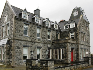
| Ennistimon House | In 1786 Wilson refers to this house at "Innistymond" as the seat of Edward O'Brien. Lewis writes in 1837 that Ennistymon Castle was originally a seat of the O'Brien family, descendants of the Earls of Thomond, but was then the residence of Andrew Finucane. By the time of Griffith's Valuation it had passed into Macnamara possession. The O'Brien, Finucane and Macnamara families had all intermarried. The house was valued at £28 in the mid 19th century and held by Captain Francis Macnamara in fee. It remained in Macnamara ownership until the mid 20th century and has been a hotel for many years. The hotel was the property of Mr Brendan O'Regan in the 1940s. |
|
| Erne Head | In 1837 Lewis referred to “Kilrea” as the seat of H. Dopping . Henry Dopping held this property in fee at the time of Griffiths Valuation in the 1850s when it was valued at £15. It is labelled Erne Head on the 25-inch Ordnance Survey map of the early 20th century. The house at Culray was the property of Reverend Francis Dopping in 1906 when it had a valuation of almost £18. It is no longer extant. | |
| Erne Hill House | Located on the outskirts of Belturbet, Erne Hill House was the home of George M. Knipe with a rateable valuation of £45, at the time of Griffith’s Valuation. By 1878 John E. Vernon was living at Erne Hill. The Knipe mausoleum is nearby and a gate lodge is extant but the house is demolished. |
|
| Errew | An unoccupied house and offices valued at £11 were held by James Hardiman at the time of Griffith's Valuation. A school and monastery are shown on the 25-inch Ordnance Survey map of this area in the 1890s. These buildings are still extant. | |
| Errew Grange | A Victorian Gothic house built circa 1870s. It was bought from Granville Knox by the Burkes of Ballina, solicitors. The Burkes leased it to the Order of Jesus and Mary before the Order moved to Gortnaraby in 1916. It became a hotel but burnt down in 1949 and was later restored. |
|
| Erribul | A steward's house built in the 1840s by Colonel George Wyndham and valued at over £12 at the time of Griffith's Valuation. It is labelled Erribul House on the 25-inch Ordnance Survey map of the 1890s and is still extant. | |
| Errina House | This house located on the west bank of the River Shannon was occupied by Thomas R. Going in 1814, George Vincent in 1837 and at the time of Griffith's Valuation when he held the house valued at £25 from the Reverend Charles Minchin. The house was later occupied by Admiral Hayes O'Grady, father of Standish Hayes O'Grady. The house became the home of the Bourke family in the 1920s and was demolished in the 1940s. There was another large house known as Errina closeby Grid Ref R657 637. | |
| Errislannan Manor | Originally a shooting lodge, extended by the Wall family and renamed. It remained in the ownership of the Walls and their descendants until 1958 when it was sold to Doctor Donal Brooks and his wife Stephanie who run a Connemara Pony Stud and trekking centre. | |
| Errit Lodge | Errit Lodge, valued at £12, was the residence of Fitzstephen French at the time of Griffith's Valuation. It is recorded as Lough Errit by Lewis in 1837 when the Ordnance Survey Name books describe it as " a well built house, two stories high and slated with detached offices". Slater refers to it as the seat of Hon. Charles French in 1894. In 1814 Errit is recorded as the residence of John Barlow. The Census of Elphin in 1749 also records it as a residence of W. Barlow. A modernised and derelict building now occupies the lakeshore site. |
|
| Esker | Occupied by W. Kelly in 1837. Bought by the Glennon family and occupied by them for most of the 20th century, still extant. |

|
| Esker | In 1786 Wilson refers to Esker as the seat of Mr. Daly, "situated on a lofty hill". By the time of Griffith's Valuation this property was being leased to the Dominican Order by Lord Dunsandle, when it was valued at £20. The Dominicans departed in the 1860s and it became for some time a seminary for the RC diocese of Clonfert. It was taken over by the Redemptorist Order in 1901, in whose possession it still remains. It now serves as a retreat centre. |
|
| Esker Lodge | James Martin was leasing a property valued at £15 from Andrew Browne's estate at Esker, barony of Tiaquin, at the time of Griffith's Valuation. It is labelled Esker Lodge on both the 1st and 25-inch edition Ordnance Survey maps. A small amount of ruins remain at the site. | |
| Essex Lawn | Built after the First Ordnance Survey on part of the estate of the Earl of Essex, this house was occupied by John Kelly in the 1850s when it was valued at £18 10s. It is still extant. |
|
| Estersnow Glebe | At the time of Griffith's Valuation the Ecclesiastical Commissioners were leasing a house at Cavetown valued at £10 to Rev. Frederick Hamilton. It is described as "a good glebe house, the residence of the incumbrant of Estersnow" at the time of the 1st Ordnance Survey. It is still extant and occupied. | |
| Etna Lodge | There was a building at this site, close to the border with county Fermanagh, marked on the 1st edition Ordnance Survey map (1836). However Etna Lodge was built post 1836. It was valued at £14 in the mid-19th century, occupied by the Reverend Charles Walsh and held from William Phillips. The Medical Register of 1885 lists Alexander Knight as resident. This building is still extant. | |
| Eyon | The Ordnance Survey Name Book records this house as costing £500 to build in 1838 when it became the seat of Mr Richard Laffan. The house valued at £12+ at the time of Griffith's Valuation, was occupied by Richard Laffan, a dairy farmer. Laffan held the property from Edward B. Hartopp. ''Burke's Irish Family Records'' records Edward Lloyd of Eyon in the mid 18th century. | |
| Eyrecourt Castle | Eyrecourt Castle was originally built in the 1660s. In 1786 Wilson refers to it as "the fine seat of Lord Eyre, with ample demesnes". It is mentioned as a gentleman's seat in the Ordnance Survey Name Books in the 1830s. It was held in fee by John Eyre at the time of Griffith's Valuation when it was valued at £48. A fine lithograph of the Castle appears in the Encumbered Estates schedule when the estate was offered for sale in June 1854. The castle itself is now in ruins. The fine oak staircase is now in the Detroit Institute of Arts. Substantial evidence of the demesne still remains. |
|
| Eyreville | A late 18th and early 19th century house built for the Eyre family. Lewis records Eyreville as the seat of T.S. Eyre in 1837. In 1856 Thomas Stratford Eyre was occupying a property valued at £36 in Newtowneyre, parish of Kiltormer, barony of Longford. in 1906 it was in the possession of the representatives of Thomas D. Eyre. In 2006 permission was being sought to carry out works on the site of Eyreville. While the house is no longer extant the remains of demesne buildings exist. |
|
| Factory Hill | The seat of a branch of the Hoare family in the 18th and 19th centuries. Occupied by E. Hoare in 1814 but by 1837 leased to William Letchfield or Lichfield. He occupied the house in the early 1850s when it was valued at £25. Richard Martin of Factory Hill owned 506 acres in county Cork in the 1870s. A larger property, known as Dunsland House, occupies the site of Factory Hill on the 25-inch Ordnance Survey map of the 1890s. This latter property was later the residence of Joseph Pike and was burnt in August 1920 during the War of Independence. |

|
| Faha | A property that was in the possession of the Tuthill family from the early 18th century, Wilson refers to it as Mr. Tuthill's seat in 1786. Occupied by Christopher Tuthill in 1814 and by his son George in 1837. Held by George Tuthill in fee at the time of Griffith's Valuation when the buildings were valued at £60. Thompson Russell lived at Faha in the second half of the 19th century. Valued at £52 in 1906 and occupied by George Taylor who held it with 308 acres of untenanted land. It is now a ruin. |
|
| Fahafeelagh | In 1851, Nicholas Power was leasing this property from the Barron estate when it was valued at £13. Recorded as the address of Catherine Barron in the 1870s. Wilson, writing in 1786, refers to Faghs as the seat of Mr. Barron. Buildings are still extant at this site. | |
| Fahagh Court | In 1786 Wilson mentions Fagha as the seat of Mr. Falvey. At the time of Griffith's Valuation, Daniel Buckley was leasing this property from John Morrogh Bernard, when it was valued at £3 10s. In 1906 Bertram Morrogh Bernard owned this property, then valued at £25. A house built n the later nineteenth century, it is labelled Fahagh Court on the 25-inch Ordnance Survey map of the 1890s. In 1943 the Irish Tourist Association survey noted that it had been extensively reconstructed and modernised and "bears little resemblance to the historic residence of the Morrogh-Bernards and before them the O'Flavey clan". It was then occupied by the Reynolds family. Bary states that the property became a hotel in the twentieth century before being damaged by fire. The extensive yard complex has now become the Killarney Country Club and holiday accommodation. |

|
| Fahalea | Thomas Daunt held this property in fee at the time of Griffith's Valuation, when it was valued at £10. Extensive farm buildings exist at the site now. | |
| Fahan House | Elizabeth Jones was leasing this property from the Norman estate at the time of Griffiths Valuation in the 1850s, when it was valued at over £28. In 1837 Lewis referred to it as the seat of T. Kough. The National Inventory of Architectural Heritage suggests this house was built in the 18th century and extended in the 19th. It appears to be associated with a number of different families. |
|
| Fahan Rectory | William Alexander held this property in fee at the time of Griffiths Valuation in the 1850s, when it was valued at £26. In 1837 Lewis referred to the Glebe House as the residence of Reverend W. Hawkshaw. A house is still extant at the site. |
|
| Faheens | An O'Donnell residence in the 1830s. No house with a substantial valuation exists in the townland by the time of Griffith's Valuation. | |
| Fahy | Built 1796, a former Paget home occupied by Ernest Knox of the Castlereagh family in the late 1830s. Lackland Chisholm was the tenant at Fahy in 1853. The original house is no longer extant. | |
| Fair View (Dane Ville) | The property at this site is labelled as Fair View on the 1st edition Ordnance Survey map of the late 1830s. On the 25-inch edition of the early 20th century it is labelled Dane Ville Lodge. At the time of Griffith’s Valuation, it was being leased by Mrs. Deane from the representatives of Colonel Dickson and Thomas Conolly’s estate when it was valued at £18. The site is now occupied by a modern house. | |
| Fair View (Longford) | Jeremiah Gibson was leasing this property from the Gunning estate at the time of Griffiths Valuation in the mid-1850s, when it was valued at over £18. A later house possibly exists at the site now. | |
| Fair View, later Dane Ville | The property at this site is labelled as Fair View on the 1st edition Ordnance Survey map of the late 1830s. On the 25-inch edition of the early 20th century it is labelled Dane Ville Lodge. At the time of Griffith’s Valuation, it was being leased by Mrs. Deane from the representatives of Colonel Dickson and Thomas Conolly’s estate when it was valued at £18. The site is now occupied by a modern house. | |
| Fairbrook House | At the time of Griffith's Valuation, Patrick Stephenson was leasing an extensive mill complex from Thomas Gamble at this location. It is described as Fairvew Paper Mill on the 1st edition Ordnance Survey Map and as Fairbrook Factory on the later 25-inch edition. The house and mill had a combined value of £95. The buildings are still extant. |
|
| Fairfield | Fairfield was the birthplace of the Reverend John Richard Darley in 1799 who became Bishop of Kilmore in 1874. Facing the shore of Inner Lough it is named on the 1st edition 6 inch Ordnance Survey Map (1836). The Field Name Book states that it was the property of Lord Cremorne let to the former proprietor Mr Corry. Griffith’s Valuation records Lord Cremorne as the occupier holding it in fee. The buildings were valued at £23. By the early 20th century this house was no longer in use. The site is now surrounded by a forest. | |
| Fairfield | Valued at £18 and held in fee by Pollok at the time of Griffith's Valuation. It is no longer extant. | |
| Fairfield (Kilgerrill) | Wilson, writing in 1786, notes Fairfield as the seat of Mr. O'Brien. In 1837, Lewis records Fairfield as the seat of John O'Brien. At the time of Griffith's Valuation Fairfield was leased by James Thorngate to Daniel Cruise. Taylor and Skinner record Fairfield as a seat of the O'Brien family in 1783. The original house is not extant. |
|
| Fairfield House | Lewis records Fairfield as the residence of T. Wade in 1837. It is described in the Ordnance Survey Name books as "built on rising ground from which there is a good prospect". At the time of Griffith's Valuation the house was being leased by Thomas Wade from the Handy estate. In 1906 it was in the possession of Rochford Wade when it was valued at £23. Fairfield House is no longer extant and the demesne is the focus for a major sawmilling operation. |
|
| Fairhill | Built in the late 18th or early 19th century, Fairhill was the home of the Fair family. It became established as a well known guest house for fishermen in the 20th century and is now a modern hotel run by descendants of the Fairs. |

|
| Fairview | Part of this house, situated on the Verner estate, dates from the late 18th century. Fairview is named on the first edition 6 inch Ordnance Survey map. The building was only valued at £4 in Griffith’s Valuation, when it was occupied by William Lockart. It was considerably added to sometime in the mid-19th century. James Lockart occupied the house in 1910 (Ulster Towns Directory 1910). |
|
| Fairview (Inishowen) | John Harvey held this property in fee at the time of Griffith’s Valuation, when it was valued at £10. This property is marked as Fairview Demesne on the 1st edition Ordnance Survey map but the house is not named. Neither house nor demesne are named on the early 25-inch edition. It is no longer extant. | |
| Fairy Hill | At the time of Griffith's Valuation Robert De La Cour was resident at Fairy Hill, which he held from the Earl of Limerick. The buildings were valued at £36. Hajba writes that Robert lived in this house from circa 1817 to 1878. The property then passed to his niece, Miss Herrick of Shippool, who married William Nicholas Wrixon Becher in 1888 and this couple lived at Fairy Hill. Fairy Hill was in use as a nursing home at the beginning of the 21st century. | |
| Fairy Hill | James O'Brien was living in this house in 1814 and it remained in the possession of O'Briens until the 1860s. Valued at £5 at the time of Griffith's Valuation when the Reverend Daniel Lynch was in residence. Occupied by the Lynch family in the 20th century. |