Browse Houses
Search Results: Returned 5927 records. Displaying results 2501 – 2600
| House name | Description | |
|---|---|---|
| Fairy Hill | This house was situated on the Gore estate and was the residence of John McDonnell in the mid 19th century who held the property from Charles William Gore. It was valued at £14. In 1837 it was inhabited by E. Burnard. Although the house became derelict in the early 20th century it was later reconstructed and is still a residence. | |
| Fairy Hill | Thomas Doolan was leasing a property at Fairy Hill, valued at £20, to Charles Cooper at the time of Griffith's Valuation. Slater had noted it as the residence of Thomas Doolan in 1846. In 1894 Slater records Fairy Hill as the seat of Colonel Cheevers. This house is still extant. |
|
| Fairyhill | Fairyhill was the home of William Henry Cox in 1837. The Ordnance Survey Name Books describe it as "a large mansion house, the residence of Mr. Cocks [sic]" in 1841. It was occupied by Ellen Robinson in the early 1850s, when the house was valued at £19 and held from Lord Ashtown. Valued at £16 in 1906 and held by George W. Robinson. This house is still in use as a residence. |

|
| Fairyhill House (Clonmel) | Leased by Thomas Hughes to David Franks at the time of Griffith's Valuation in 1850 when it was valued at almost £27. Fairy Hill is still extand and occupied. |
|
| Fairymount | In 1786 Wilson writes that Fairy-Hall was the seat of Hon. Rev. Mr. Murray. It was the residence of Robert Going in 1814 and of Henry O. Bridgeman in 1837 and at the time of Griffith's Valuation. The house was located in the townland of Montpelier on the De Burgho estate and was valued at £16. It was surrounded by a 35 acre demesne. This house is called Fairymount on the first Ordnance Survey map and in Griffith's Valuation. Fairyhall was the name of the townland just to the north of Montpelier. Farm buildings are still extant at the site. | |
| Fairymount | The home of Edward Mills in 1814. In 1828 Edward Mills of Fairymount was a member of the Grand Panel of county Roscommon. Residence of Mr Lyster at the time of the first Ordnance Survey. By the time of Griffith's Valuation the largest house in the townland of Fairymount was valued at £1.15s, leased by Anne Lyster to Michael Connolly. | |
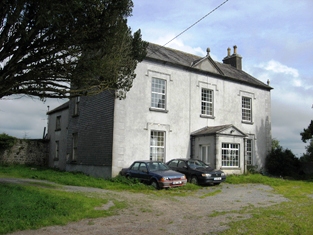
| Faithlegg House | At the time of Griffith's Valuation, Faithlegg House was owned by Nicholas O'Neill Power and valued at £100. The lands in this area were originally held by the Aylward family after the Norman Conquest but they were dispossessed by Cromwellian forces in the 1650s. Faithlegg was then acquired by the Bolton family who eventually built the house in the eighteenth century. It was sold by them to the Power family in 1819. It was enlarged and extended under Power ownership and in 1906 was valued at £110. Faithlegg remained in the Power family until 1935 when it was sold to the De La Salle order who used it as a novitiate until the 1980s. It is now Faithlegg House Hotel. See www.faithlegg.com. |
|
| Falleen | The home of the Hawkeshaw family in the 19th century, held from the Bowens of Bowens Court. Benjamin Hawkeshaw is recorded as the occupant in 1814 and in the early 1850s when the house was valued at £13.14 shillings. G. Riall was resident in 1837. The Ordnance Survey Name Books refer to Falleen as the seat of James Bennett in 1839. A house is still extant at the site. | |
| Falmore House (Inishowen) | James Nicholson held this property in fee at the time of Griffith’s Valuation, when it was valued at £16. This house was built after the publication of the first OS Map. It is labelled as Falmore House on the 25-inch map of the early 20th century. The National Inventory of Architectural Heritage notes that a plaque on the house records its building by J. Steele Nicholson in 1850. It is now derelict. |
|
| Faltia House | Daniel Mathers occupied Faltia House, barony of Moycarn, at the time of Griffith's Valuation, when it was valued at £9. It was part of a demesne of over 400 acres. The Ordnance Survey Field Name books of 1837 describe it as "a gentleman's place in good repair". | |
| Fanningstown Castle | An 18th century house which was the home of the Jackson family. Henry Lee is recorded as resident at Fannings-town in 1814. This house was demolished and a battlemented building was erected in the bawn of the old medieval castle by Hamilton L. Jackson in the 1850s and offered for sale in 1860. Bought by David Vandeleur Roche of nearby Carass in the 1860s. Occupied by James Fitzgerald Bannatyne in 1906 who held the mansion house valued at £31+ and 359 acres of untenated land. The castle now provides self catering accommodation and can be hired as a venue for functions such as weddings. http://www.fanningstowncastle.com/index.htm |

|
| Fanore Lodge | This house was located on the O'Brien estate. Occupied by Richard Blood in 1814 and by Robert Johnston at the time of Griffith's Valuation, when it was valued at £5.10 shillings. Robert Johnston held the house and 950 acres from Jemima O'Brien. Weir writes that the house later became a police barracks. Buildings are still extant at the site. | |
| Far View House | Far View House, an early 19th century two-bay, three storey house, originally a home of the North family. David North who married Catherine Pim was resident in 1837 and at the time of Griffith’s Valuation (publ. 1854), when the house was valued at £15 and held from Catherine Reynolds. The house was occupied by the Gavin family in the early 20th century. |
|
| Faragher Lodge | Lodge was the residence of Thomas Hawkes in 1814 and Faragher Lodge of the Reverend Lewis Hawkes in 1837. | |
| Fardrum House | Fardrum House, an early 19th century house, named on the first edition OS map. Described by the National Built Heritage Service as a highly appealing early nineteenth-century gentleman’s cottage. Valued at £12 at the time of Griffith’s Valuation (publ. 1854) it was occupied by Eliza Mathews who held it from John Ennis. Later occupants have been the Robinson and Campbell families and it remains a family residence. |
|
| Farm Hill | A house marked on the 1st edition Ordnance Survey map with a corn mill nearby. This house looks reduced in size on later maps. In the mid-19th century occupied by Hugh Swanzy and held from Thomas Rothwell. The house was valued at £15 with corn and flax mills and miller's house valued at £35. Part of the existing farmyard may date back to circa 1800. |

|
| Farm Hill | In the mid 19th century occupied by Mrs Hannah Goold, valued at £13 and held from Richard and Jonas Morris. This house is marked on the first Ordnance Survey map and a building is still located at the site. | |
| Farm Hill (Reduff) | A house marked on the 1st edition Ordnance Survey map with a corn mill nearby. This house looks reduced in size on later maps. Described in the Ordnance Survey Field Name Book as a ‘small 2 storied house with some scattered portions of plantation around it and extensive corn mill nearby’, occupied by ‘Mr Robinson’. In the mid-19th century occupied by Hugh Swanzy and held from Thomas Rothwell. The house was valued at £15 with corn and flax mills and miller's house valued at £35. Part of the existing farmyard may date back to circa 1800. This house and its yard buildings are now part of a working farm. |
|
| Farm Lodge | Marked as Farm Lodge on the first Ordnance Survey map this house on the De Vere estate was occupied by James Potter in the early 1850s when it was valued at £16. An extensive farm still exists at the site. | |
| Farmhill | Joseph Kelly was leasing a property valued at almost £10 from Charles Kelly at Farmhill, barony of Tiaquin, at the time of Griffith's Valuation. A house still exists at this site. | |
| Farmhill | Built in 1780 this house became the principal seat of the Gardiner family. It was left by Harriet Gardiner to Susan Pringle who died in 1910. Farmhill then became the parochial house until the 1950s when it was demolished. Only the large walled garden now remains. | |
| Farmhill (Donegal) | Jacob Spence was leasing this property from the Arran estate at the time of Griffith’s Valuation in the 1850s, when the complex was valued at £23, including a flax mill and a corn mill. | |
| Farmhill/Carradoyne | In 1786, Wilson refers to Farmhill as the seat of Mr. Vesey. Dean Arbuthnot, who lived in the house in 1814, was rector of the parishes of Crossboyne and Kilcolman and a brother of Sir Robert Arbuthnot. The Gonne Bells were recorded as resident in Lewis and the Ordnance Survey Name Books. The house appears to have been known as Farmhill during the Vesey/Arbuthnot/Gonne Bell ownership and thereafter as Carradoyne House. It was occupied by Thomas Elwood in 1845 and by Lady Lynch Blosse at the time of Griffith’s Valuation. By the 1860s it was the home of the Sheffields. It was occupied by Katherine Tynan and her husband, Henry Albert Hinckson, during World War I. Carradoyne House is still extant and occupied. |

|
| Farnagh | Buildings are marked at this site on the first edition OS map and the house is named on the 25 inch map. It was built in the early 19th century and a Mr Benjamin Wynne was resident in 1814. The house was extended about 1850 according to the National Built Heritage Service. This house was the residence of R. Adamson in 1837 (Lewis) and of Hannah Wynne who held it from Edward Digges La Touche, valued at £14.5 at the time of Griffith’s Valuation (publ. 1854). Edward Wakefield, a ‘gentleman farmer’ and his family were resident in the early 20th century. This house remains a family home. |
|
| Farnane House | Located on the Cloncurry estate Farnane was the home of the Costelloe family from at least 1837. Occupied by Thomas Costelloe in the early 1850s and valued at £12+. It is labelled Farnane House on the 1st edition Ordnance Survey map but is not labelled on the later 25-inch edition of the 1890s. It is no longer extant. | |
| Farney Castle | A seat of a branch of the Armstrong family. Wilson refers to this property as Farney Bridge in 1786, a seat of Mr. Armstrong. It was occupied by Captain Armstrong in 1814 and 1840, when the Ordnance Survey Name Books describe it as "a circular old castle to which a gentleman's residence has been attached". Major William Armstrong was the occupier in the early 1850s. The buildings were then valued at £42.10 shillings and held from the Reverend Garrett Wall. It was still in Armstrong possession in the 1870s. Farney Castle is still extant and occupied. |

|
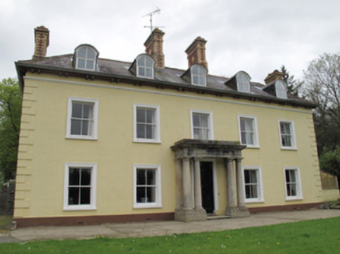
| Farnham Castle | The seat of the Maxwell family, Earls of Farnham, built about the turn of the 18th century for John Maxwell, son of the Bishop of Kilmore, who had purchased the estate from the Waldrons. A library and other alterations designed by James Wyatt were added in the 1780s. In the early 19th century Francis Johnston was employed by the 2nd Earl to rebuild the house. The buildings were valued at £120 in the mid-19th century. The house was remodelled again in the 1960s when dry rot was found to be prevalent and much of the 18th building was demolished. The house remained in the possession of the Maxwell family until the early 21st century. It is now a country house hotel. https://www.farnhamestate.ie/ | |
| Farragh | An 18th century house on the Palmer estate. Wilson refers to it as a residence of Mr. Palmer in 1786. Leased to the Waldrons in the early 19th century and occupied by Hector Sutherland at the time of Griffith's Valuation when the house was valued at almost £8. The original building is no longer extant. | |
| Farraghroe House | Willoughby Bond held this property in fee at the time of Griffiths Valuation in the early 1850s when it was valued at £55. Lewis had also referred to ‘’Farra’’ as his seat in 1837. In 1905 it was owned by James W. Bond and valued at £67. The house was demolished in the 20th century but much estate architecture, including the Steward’s House, remains. |

|
| Farran | This house was owned by Samuel Penrose at the time of Griffith's Valuation when it was valued at £24. It was also occupied by him in 1837. In 1868 Farran was bought by William Clarke and three generations of the Clarke family lived at Farran until 1970. In 1906 the buildings were valued at £226 and Thomas Clarke was the occupier. The Irish Tourist Association Survey in the 1940s describes it as "the splendid residence of Captain Clarke, living in the Channel Islands but occupied by his relatives". The present owners offer self catering accommodation for groups. see http://www.farranhouse.com/history.htm |

|
| Farran | At the time of Griffith's Valuation, William Kearns was leasing this property from the Crosbie estate when it was valued at £18 5s. Some farm buildings are still extant at the site. | |
| Farranakilla | At the time of Griffith’s Valuation, James Hussey was leasing a property valued at £26 to Edward Day Stokes. In 1837 Lewis records it as the seat of P.B. Hussey. Bary states that Farrankilla House was built c.1800 by the Hussey family. Edward Day Stokes, to whom it was leased at the time of Griffith’s Valuation, was an agent for both Lord Ventry and the Townsend estate. The house was sold several times in the 20th century. It is still extant. | |
| Farranawana House | At the time of Griffith's Valuation, this property was being leased by St. John Blacker to the trustees of Glin Poor Law Union, as an auxilliary workhouse. By 1895 it is labelled on the Ordnance Survey map as Farrawanna House. A house and farm buildings are still extant at the site. | |
| Farranhavane House | Leased by John Smith Wood from the representatives of Maskelyne Alcock in 1851 when it had a valuation of £10. It is still extant and part of a large farming enterprise. | |
| Farranredmond | At the time of Griffith’s Valuation, Robert C. Hickson was leasing this house, valued at almost £6, from Patrick Stack. The latter held other property in the same townland from Lord Ventry’s estate. Buildings are still extant at the site. | |
| Farrenmacfarrell | James Ormsby was occupying this property at the time of Griffith's Valuation, when it was valued at £6. McTernan states that the house was built by Thomas Ormsby at the end of the eighteenth century. In 1906, the house at Farranmacfarrell was owned by Alexander Cuffe and was valued at £7. The house is still extant but appears to be unoccupied. | |
| Faughts Cottage | At the time of Griffith's Valuation, Phillip Parke was leasing a property at Faughts, barony of Carbury, valued at £7, from John Wynne. This appears to be the house described on both the First and 25-inch edition Ordnance Survey maps as "Faughts Cottage". A house is still extant at the site. | |
| Faulkland Castle | Shirley refers to the confinement of John Leslie, Dean of Dromore, by Robert Maxwell, Sheriff of Monaghan, in his house at Falkland/Faulkland in 1707. The Maxwells occupied Faulkland Castle until 1780. By the time of Griffith’s Valuation it was valued at £1.6 shillings and was held by James Jackson Senior from the trustees of John Maxwell. The 25 inch map (surveyed 1908) shows the castle ‘in ruins’. | |
| Faulties | At the time of Griffith's Valuation Francis Nesbitt was leasing a property valued at £11 from Catherine Warren at Faulties, barony of Mohill. Buildings still exist at the site. | |
| Feacle/Fighill | The residence of Dennis Keogh in 1814, occupied by R. Keogh in 1837 and by Richard Keogh in the 1850s when the house was valued at £2. The house has been known as Fighill since at least 1837. The old house is no longer lived in. |
|
| Fear More | Occupied by William Roper junior at the time of Griffith's Valuation and by John J. Daly in 1906. | |
| Fearmore House | In 1856 Edward Horsman was leasing a house in the townland of Fearmore from the Clanricarde estate. It was valued at almost £9 at the time. It is still extant and occupied. |
|
| Featherstone Lodge | Reverend John Fetherstonhaugh was leasing a house valued at £6 and over 1700 acres at Toorleitra from the Burke of Marble Hill estate at the time of Griffith's Valuation. Very little remains of the house and the area has been extensively planted with forestry. | |
| Fedamore | A house known as Fedamore Cottage is marked on the first Ordnance Survey map. By the early 1850s John and Edward Synan were the occupiers of a house valued at £27 in Fedamore townland, which they held from Colonel Wyndham. The property is shown as Fedamore House on the 25-inch map of the 1890s, by which time it was the residence of J.G. Kelly. It is still extant and occupied. | |
| Feddans | Reverend John Condon, PP, was leasing this property from the Power estate in 1850 when it was valued at £11. The parochial house is labelled on the 25-inch Ordnance Survey map of the 1890s. A house is still extant at the site. | |
| Feenagh House | Feenagh House is described as "in ruins" on the 1st edition Ordnance Survey map and has almost disappeared by the publication of the 25-inch edition in the 1890s. In 1786 Wilson refers to "Fenagh House" as the seat of Mr. Wilson. By the time of Griffith's Valuation, the townland in which it was situated was the subject of Court of Chancery proceedings. Some fragments of the walls are still visible. | |
| Fell Fort | Slater noted Fellport [Fellfort] is noted as the residence of R.L. Fell in the 1890s | |
| Fenagh Glebe | Rev. George Beresford held the Glebe at Fenagh, from the Ecclesiastical Commissioners at the time of Griffith's Valuation when it was valued at £16. The Buildings of Ireland survey states that the house was built c. 1829. It also records that the nearby church, built c.1790, was extended in the 1850s by the Pack Beresford family. Both buildings are still extant and in use. |
|
| Fenit House or Fenit Lodge | Though this house was mostly associated with the Hurley family, at the time of Griffith's Valuation, it was in the possession of a Miss Locke, when it was valued at £20. It was being leased by John Murray. In 1906 it was owned by John C. Hurley and valued at £33. Bary notes that it later came into the Fuller family through marriage. It was sold in the 1970s but is still extant and occupied. |
|
| Fenloe House | A red brick two storey 18th century house, home of the Hickman family for the 18th and 19th centuries. Hugh Poole Hickman was the occupier in 1837 and at the time of Griffith's Valuation, when the house was valued at £28. He held the property from William Westby. |
|
| Feohanagh | There is no large house marked on the first Ordnance Survey map for this townland, however by the time of Griffith's Valuation in the early 1850s a house valued at £10+ was recorded in Feohanagh. It was occupied by James Wigmore and held from Viscount Lismore. [Grid reference is approximate] | |
| Fermoy House | Lewis refers to Fermoy House in 1837 as the residence of the late J. Anderson “to whom not only the town owes its prosperity but the entire country…”. It was then occupied by Mrs Hennis. The Reverend Maurice Collis was in residence by the time of Griffith's Valuation. He held the property from Sir Robert Abercrombie and the buildings were valued at over £50. In 1786 Wilson writes of a house at Fermoy, the seat of Mr. Bryan. The Irish Tourist Association Survey of 1942 states that Fermoy House was then the property of Maurice Cooke Collis and was divided into five flats. The house was demolished in the 1960s. | |
| Fermoyle Castle (Iveragh) | Charles Sugrue was in possession of this property at the time of Griffith's Valuation, when it was valued at £15. In 1906 it was owned by the representatives of Edward Sugrue. Bary states that there was originally an O'Sullivan castle at this site, on to which a house was built by John Sugrue in the 1820s. The Sugrue family later moved to Cork and the house was used for some years as the local Catholic presbytery. It is now a ruin. | |
| Fermoyle House | At the time of Griffith’s Valuation, Robert C. Hickson was leasing this house, valued at £28, from the Earl of Cork’s estate. Lewis notes Fermoyle House as the seat of J. Hillyard in 1837. In 1906 it was the property of George A. Hickson and valued at £25. Bary states that the house was, for a long period, associated with the Conway Hickson family. It is still standing and inhabited. |

|
| Fermoyle Lodge | Built in 1875 by the Berridge family as a shooting lodge. It has since served as a guest accommodation and an art gallery and has been offered for sale on a number of occasions. |
|
| Fern Hall | At the time of the first Ordnance Survey the Trant family were recorded as the proprietors of the townland of Polranny, barony of Castlereagh, including Fern Hall House. Henry Dillon Trant was leasing it to John Irwin at the time of Griffith's Valuation when it was valued at almost £5. Gormley states that this branch of the Irwins was the oldest in the area, having been recorded there in the sixteenth century. The house was not in good repair by the end of the nineteenth century and no trace remains now. | |
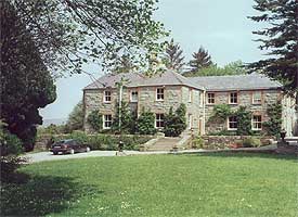
| Fern Hill | AT the time of Griffith's Valuation, this property was being leased from the Earl of Shannon's estate by Anna Atkins. It was then valued at £28. In 1837, Lewis refers to it as the seat of W.F. Atlkin. Now part of the Fernhill House hotel complex. |

|
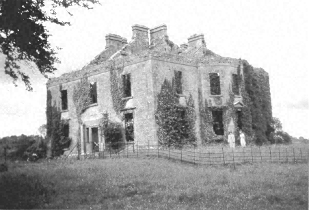
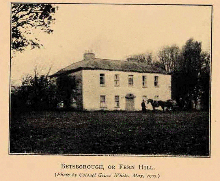
| Fern Hill | Smith records Cornelius Townshend as resident at Betsborough circa 1750. Hajba writes that it was a Townsend property from the early 18th century and birthplace of the United Irishman, Thomas Russell, executed in 1803. The house, on the outskirts of the village of Drommahane, was originally known as Bettesborough (or Besborough) and a Magner occupied a house of this name in 1837. The Reverend Philip Townsend held the house valued at £21+ from William Magner in the early 1850s. In June 1881 the house and demesne of Fernhill were advertised for sale. Barclay Corrie was the owner, holding on a lease dated 1863 from Richard John Perry to Michael Joseph Magnier. The house was demolished in the early 20th century and a new house built on the site. |
|
| Ferney | Ferney was the residence of Mrs Coote in 1814 and of J.H. Manley in 1837. Joseph Manly occupied the house valued at £68 at the time of Griffith's Valuation. He held it from Sir William Chatterton. This house is still extant. | |
| Ferney Hill | A house at this site was valued at £10, located on the Barrett-Lennard estate and held by Mary Jameson at the time of Griffith’s Valuation. The National Inventory of Architectural Heritage dates the present house circa 1890. Mulligan writes that it was built for a town merchant Mr M. Maguire. |
|
| Fernmount (Granard) | John B. Kirk was leasing this property from Richard Greville’s estate at the time of Griffiths Valuation in the 1850s, when it was valued at over £10. It is not named on the 6” OS map but a more substantial house is labelled Fernmount on the 25” map of the early 20th century. It is still extant. | |
| Ferns Hill Glebe House | This property was held in fee by Reverend G. Tredennick at the time of Griffith’s Valuation, when it was valued at £24. It is labelled as both Glebe and Ferns Hill on all editions of the Ordnance Survey maps up to the 1940s. It is no longer extant. | |
| Fernsborough | Thomas Gosselin was leasing this property from William Shirley Ball’s estate at the time of Griffiths Valuation when it was valued at £25. In 1837 Lewis noted “Fernsboro” as the seat of A. Burrows. It was also recorded as the seat of Alexander Burrowes by Leet in 1814. Fernsborough is no longer extant. Hussey de Burgh noted Thomas Gosselin as the proprietor of almost 300 acres in County Longford in the 1870s. | |
| Fiddaun Lodge | In 1786 Wilson refers to Fidane as the seat of Mr. Kelly. Melvin writes that John Dennis, the famous huntsman, was born at Fiddaun in 1800. Charles O'Rorke was leasing it from the Redington estate in the mid 1850s when the house was valued at almost £5. A house still exists at the site. |
|
| Finavarra House | The home of the Skerrett family from the mid 18th century to the mid 19th century, now a ruin. |
|
| Finisk Mill | Denis Keily was leasing this property from the Power estate in 1850 when the house and mill had a combined valued of over £37. It is labelled Finisk Flour Mill on the First edition Ordnance Survey map and as Finisk Corn Mill on the later 1890s edition. A creamery building later occupied the site. | |
| Finisklin House or Seamount | Built as a seaside residence of the Wood family though frequently leased by them to various other families. In the mid nineteenth century it was the residence of Thomas Mostyn Wood and valued at £11. In the 1870s, McTernan notes that it passed to the land agent Richard St. George Robinson, in whose family it remained until the early twentieth century. It is still extant and has been restored. | |
| Finn Lodge | Sir Frederick Heygate's estate held this property in fee at the time of Griffiths Valuation in the 1850s, when it was valued at £11. Farm buildings occupy the site now. | |
| Finned (Tireragh) | At the time of Griffith's Valuation, George Beatty (or Beattie) was leasing a house valued at £5 and almost 100 acres from the Tottenham estate. McTernan states that he was referred to at the time of the Ordnance Survey as a "middleman for a large amount of property". Later the house passed by marriage to the Boyd family who sold it in the early twentieth century. It is still extant and has been renovated. |

|
| Finned House | In 1906 Sir Jocelyn Gore Booth owned buildings valued at £8 at Finned, barony of Carbury. This is likely to be Finned House. This townland was the property of the Gore Booth estate at the time of Griffith's Valuation but the highest building valuation at that time was only £2. | |
| Finnis | Thomas Gash was leasing offices from the Devonshire estate in 1851 when the buildings were valued at £11. A house and extensive farm buildings exist at the site now. | |
| Finniterstown | Mr Edmund Hogan was resident at Finniterstown in 1814. The Ordnance Survey Field Name book records the building of a 2 storey house at Finneterstown in 1833 and that it was occupied by William Fosberry circas 1840. Located on the St Leger estate this house was occupied by Frederick Maunsell in the early 1850s and was valued at £11. | |
| Finnoe | Occupied by T. [Thomas Maunsell] Waller in 1837. The Ordnance Survey Name Books describe Finnoe as "a commodious house" in 1840. Thomas' son, Edward Waller, was the occupier at the time of Griffith's Valuation. Edward held the property in fee and the house was valued at £30. A building is still located at this site. | |
| Finnor House | At the time of Griffith's Valuation, Richard O'Farrell Caddell was leasing a house valued at £8, at Finnor, barony of Boyle, to Michael Barrett. It s labelled "Finnor House" on the 25-inch Ordnance Survey map of the 1890s and a house still exists at the site. | |
| Fintragh | Anne Hamilton was occupying the house at Fintragh at the time of Griffith’s Valuation when it was valued at £16. A newer house was constructed at Fintragh in the later 19th century[G689766]. It was burned in 1923, though reconstructed before being demolished in the later 20th century. The stableblock, built on the site of the original Fintragh House, is still extant, and has operated as a restaurant. |
|
| Finuge House | Rev. Maurice Hewson was leasing this property to William M. Hewson as the time of Griffith's Valuation, when it was valued at £13 5s. In 1837, Lewis notes it as the seat of W. Hartnett. Bary states that it was burnt in the early twentieth century and nothing now remains. | |
| Firgrove | Hogan writes that the building of Firgrove was begun by Thomas, son of Thady O'Halloran, the diarist, and completed by John MacMahon of Knockane. John Peter Kelly took over the house from MacMahon. In 1851 Eliza, daughter of John Scott of Firgrove, married George Fosbery of Clorane, county Limerick. The house was occupied by Charles Butler in the mid 19th century who held the property from John Kelly. It was valued at £35. The house was demolished in the 1920s. |

|
| Firgrove | At the time of Griffith's Valuation, the representatives of Chambre Corker were leasing this property to Richard Quinn when it was valued at £18. In 1837 Lewis notes it as the seat of R. Quin. In 1906 it was held by the representatives of Mary Quinn and valued at £7 10s. A house still exists at this site. | |
| Firmount | A Townsend family home, occupied by Horace Townsend in 1837 and by William Coghlan at the time of Griffith's Valuation. It was then valued at £14.10 shillings and was held from Horatio Townsend. The sale rental of 1877 records a fee farm grant of Firmount from John Crewe Chetwood Townsend to Arthur Chute dated 1871 and a fee farm grant from Arthur Chute to J.C.C. Townsend executed the following year. A house is still extant at the site. | |
| Firmount | The seat of the Firman family in the late 18th century, occupied by Thomas P. Terman in 1814. The house is marked on the first edition Ordnance Survey map. The Ordnance Survey Name Books refer to it as "the mansion house of Firmount now falling into ruins, It appears to be a ruin by the time of Griffith's Valuation. The only buildings over £10 valuation were the Santa Cruise flour mill and house of Samuel Palmer. The Irish Tourist Association surveyor records "an extremely charming house converted from stabling" at Firmount and occupied by Major H.H. Deasy in the early 1940s. The surveyor states that the original house was destroyed by fire. | |
| Firville | In 1841 the Ordnance Survey Name Books refer to "Ferville" as the residence of R.F. Drought. William S. Smith occupied the house in the mid 19th century which he held from Ralph Smith. It was valued at £15+. This building is still part of a farm complex. | |
| Firville | Leet lists a Robert McCarthy residing at a house called Fir-ville, Macroom in 1814. Lewis refers to Firville, the newly erected mansion of Philip Harding. Henry Harding was the occupier in the early 1850s holding the property from N.D. Murphy. It was valued at £19.10 shillings. The representatives of Henry Harding still owned Firville in the 1870s. Firville passed to the Barry family through the marriage of Ellen Harding, daughter of Henry Harding, and Thomas Barry, son of Michael Barry of Elm Park, Farran, county Cork, land agent to Sir Riggs Falkiner. In 1944 the Irish Tourist Association Survey noted that Firville was then the residence of F. St.Aubyn Horgan, who had connections with the Channel Islands. Firville is still extant and occupied. | |
| Firville | A home of the Atkins family in the 18th and 19th centuries which in the early 1850s was held from John Clarke with 251 acres. Major Atkins occupied the house in 1814 and R. Atkins in 1837. Hajba writes that the Reverend Philip Atkins-Going left Firville to his unmarried daughters Charlotte and Henrietta when he died in 1861. Hussey de Burgh records Mrs Charlotte Henrietta Atkins of South Mall, Cork, owning 502 acres in the 1870s. Sold to Samuel Sheehan in 1914 this property still belonged to his descendants at the beginning of the 21st century. |
|
| Fisherhill | Occupied by Major Blake in the early 19th century. Fisherhill and the lands of Carheens, were leased by Richard D'Arcy of New Forest, county Galway to Edward Cheevers of Killyan, county Galway on 23 Mar 1858. In 1879 Robert Ireland advertised for sale his interest in Cheevers lease. A. C. Larminie lived here in the late 19th century. Now the home of the McGreal family. |
|
| Fishmoyne | A junior branch of the Carden family lived at Fishmoyne from the mid 18th century. Bence Jones writes that the house was built in the 19th century replacing the original house which was destroyed by fire. Wilson, writing in 1786, notes Fishmoynne as the seat of Mr. Carden. A Mrs Butler was resident in 1814 and R. Minchin Carden in 1837. Richard Carden held the property in fee in the early 1850s when it was valued at £56.17 shillings. This house remained the property of the Carden family until 1955. The Irish Tourish Association survey records the house as "idle and locked up" in the early 1940s. Fishmoyne is no longer extant. | |
| Fivemilebridge Mill House | Joseph Coghlan was leasing this property to William Herrick at the time of Griffith's Valuation, when it and the adjacent mill were valued at £53. The mill buildings are no longer visible on the 25-inch map of the 1890s. The house is still extant. |
|
| Flanker House | The Walsh estate, including Drumsna House, was advertised for sale in the Landed Estates' Court in 1861. The sale notice describes the dwelling house as "handsome and commodious" with a large walled garden. At the time of Griffith's Valuation Mary Anne Walsh was leasing the house, valued at £22 from Josias Rowley. The accompanying map indicates that it was called Flanker House. In the 1870s several members of the Keogh family, with an address at Flanker House, Drumsna, held property in county Roscommon. |

|
| Flaxfort | Occupied by R. Martin in 1837 and by Mary Anne Martin at the time of Griffith's Valuatioan. The house was valued at £21 and held from John Purcell. It is no longer extant. |
|
| Flaxfort House or Seaview House | At the time of Griffith's Valuation, William Scott was leasing this propert to Rev. Robert Taylor, when it was valued at almost £10. Lewis records it as the residence of Rev. Robert Taylor, PP, in 1837. It is labelled Seaview House on the 1st edition Ordnance Survey Map but it had become known as Flaxfort House soon after. | |
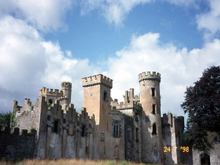
| Flesk (Glenflesk) Castle | Daniel C. Coltsmann was in possession of Flesk Castle at the time of Griffith’s Valuation when it was valued at £50. Lewis records it as the seat of J. Coltsmann in 1837. Bary states that the house was also known locally as Glenflesk Castle or Coltsmann’s Castle. It was built in the early decades of the 19th century and continued in the Coltsmann family and their descendents until the early 20th century when it was sold to Major John McGillycuddy. In 1943 the Irish Tourist Association survey noted that "its tall fantastic turrets dominate the countryside". It was then in the possession of Anthony McGillycuddy. It had become ruinous by the end of the 20th century although there were some indications that it might be restored. |
|
| Flesk Cottage | At the time of Griffith’s valuation, this house is recorded as part of the Herbert estate but was unoccupied. It was valued at £24 at the time. Lewis records it as the seat of Capain Godfrey in 1837. The Ordnance Survey Name Books record it as the residence of Arthur Saunders c.1840. Bary states that this house was frequently occupied by the Godfrey family. The ruins are close to the Gleneagles hotel. | |
| Flesk Lodge | At the time of Griffith’s Valuation, Rev. Richard Herbert was leasing a property to Rev. Robert Hewson when it was valued at £6 10s. Bary states that the latter is recorded as having died at Flesk Lodge in 1880. Since 1957 the site has been occupied by the Gleneagle hotel. | |
| Flesk Priory | The representatives of John Coxon were leasing Flesk Priory to Margaret Newman at the time of Griffith’s Valuation, when it was valued at £26. In 1837 Lewis mentions it as the seat of J.S. Coxon. Bary states that, while O’Donovan claimed it had been built in 1828, it is possible that it was erected in the 18th century. Local tradition maintained that it was to provide accommodation for noble refugees from the French Revolution. It was still extant at the end of the twentieth century. | |
| Flintfield House | This house was a seat of the Chinnery family from the mid 18th to the mid 19th century. It was occupied by Barry Cotter in 1814 and by Denis O'Connell in 1837 and at the time of Griffith's Valuation. The buildings were valued at £18+ and the property was held from John Orpen. Home of the MacSweeneys in the 20th century. |
|
| Flower Hill | Flower Hill was being leased by Magdalene Irwin from the Perceval estate at the time of Griffith's Valuation when it was valued at £3. The Irwins had a modest house at this location and in the 1820s set about building a larger property. Due to debt and court proceedings it was never finished and remains a roofless ruin. | |
| Flower Hill | Flower Hill was occupied by Anthony F. Nugent at the time of Griffith's Valuation when it was valued at £28. IN 1894 it was the residence of Charles Nugent. Flower Hill is still extant and now operates as an equestrian centre. See www.flowerhill.net |
|
| Flowerhill House (Waterford) | Flowerhill was leased by Nelson T. Foley to Barry Drew in 1851. Lewis also refers to it as the seat of B. Drew, describing it as " a beautiful residence in the cottage style". The house is no longer extant. | |
| Fohenagh | Sir Henry Grattan Bellew dates this house from the 1830s. In 1906 Norah Johnston was the owner of buildings valued at £10 at Fohenagh as well as over 500 acres of untenanted land. Various members of the Johnston family had held lands in the area at the time of Griffith's Valuation mostly leased from the Hodson estate. Buildings still remain at this site. | |
| Ford Lodge | Located on the Farnham estate just outside Cavan town and close to St Patrick’s Cathedral, Fort Lodge is named on the first edition six inch Ordnance Survey map (publ. 1837). R. Young Reynolds of Fort Lodge, Cavan, was a subscriber to Lewis ‘Topographical Dictionary’. It was occupied by Theophilus Thompson in the mid-19th century and valued at £27 for rates. Home of William Henry Halpin, a solicitor, in the 1930s. | |
| Forest House | In 1750 William Spread was living at Forest and in the 1770s and 1780s Spread Esq is recorded as resident at Forest. In 1814 Leet records this "seat" as unoccupied. T. Gollock was resident in 1837 and Thomas Gollock held the property in fee at the time of Griffith's Valuation when it was valued at £38. Slater records it as the seat of Rev. T.H. Gollock in 1894. Forest was burnt in July 1921 just before the end of the War of Independence when it was the property of James Gollock and occupied by Lt. Col. Isaac Burns-Ludlow. The Irish Tourist Association survey refers to this in the 1940s as it having been burnt "as a military precaution". It is no longer extant. |