Browse Houses
Search Results: Returned 5927 records. Displaying results 2801 – 2900
| House name | Description | |
|---|---|---|
| Glenastar Cottage | Occupied by William Osward circa 1840 and described as a large house of 2 storeys. Held by William R. Yeilding in fee at the beginning of the 1850s and valued at £7.5 shillings. The residence of Richard M. Yielding in 1814. |
|
| Glenbeg House (Lismore) | In 1851 Glenbeg House was owned by Thomas Foley but was vacant. It was valued at £23 10s at that time. In 1837 Lewis refers to it as the seat of G. Bennett Jackson. The original house dates from the mid-sveenteenth century though it was renovated in the nineteenth and twentieth centuries. Smith, writing in 1774, refers to it as the seat of Mr. John Jackson. Sadleir, referring to Rowland Jackson in 1775, notes that he was "of Glanbeg". Brady notes that the Jacksons were employed by the first Earl of Cork in the early seventeenth century. Described as "an ordinary farmhouse" in the ITA Survey in 1942. It is still extant and occupied. |

|
| Glenbeigh Towers | In 1906 the representatives of Rowland Winn were the owners of a house valued at £36 at Killnabrack, in the parish of Glanbehy. Bary identifies this as Glenbeigh Towers, built in the medieval castle style in the late 1860s. It is now a ruin. |

|
| Glenbevan | Lewis records J. Bevan as the proprietor of Glen-Bevan in 1837 and Joseph Bevan occupied the house and 173 acres at the time of Griffith's Valuation. The property was located on the Evans estate. The residence of Mr John Hedderman in 1943, this house is still extant and occupied. |

|
| Glenboy | There were two houses at Glenboy townland, one at least of which was part of the Clements estate but appears to have been leased for long periods to the Algeo family. John Marcus Clements, MP for Leitim, is described as "of Glenboy". He was nephew of Robert Clements, 1st Earl of Leitrim. A house at Glenboy was the residence of John Algeo in 1814. Glenboy is described as a seat of the Algeo family by Lewis in 1837 while Hollymount is the residence of the Armstrong family. At the time of Griffith's Valuation, Lewis Algeo was leasing house at Glenboy, valued at £25, to Simon Armstrong while he was also leasing a house from the Clements estate valued at £12. Houses are still extant at these locations. | |
| Glenbrook | At the time of Griffith's Valuation, William Smyth was leasing a house and mill complex from the Bagwell estate, then valued at almost £27. By the end of the nineteenth century the mill is no longer functioning and the house has become known as Glenbrook. | |
| Glenbrook Cottage | Thomas Holmes was leasing this property from the Massy-Dawson estate at the time of Griffith's Valuation when it was valued at almost £4. It is not named on the 1st edition Ordnance Survey map but appears as Glenbrook Cottage on the 25-inch edition of the 1890s. It is still extant and occupied. Local sources suggest that the original house dates to the seventeenth century and that the Holmes family called it Clydeingrove. |
|
| Glenburn | Glenburn was occupied by A. Lewis in 1837 and was held in fee by John T.C. Gibbings at the time of Griffith's Valuation. The buildings were valued at £20.15 shilllings. |

|
| Glenburne Cottage | Located on the outskirts of the village of Rockcorry on the Cremorne estate, Samuel Lewis in the 1830s refers to ‘Glenburie Park’ as the residence of C. Stewart Corry. Rebecca Murray was the occupant at the time of Griffith’s Valuation circa 1860 when the buildings were valued at £25. Home of the McFadden family in the early 20th century, no longer extant. | |
| Glenburnie | Reverend T.B. Gough was leasing this property from Gardner Boggs at the time of Griffith’s Valuation, when it was valued at £22. The National Inventory of Architectural Heritage suggests that the house now occupying the site was built in the later decades of the 19th century possibly incorporating the earlier house. | |
| Glencairn Abbey | Glencairn was held in fee by Jervis (Gervase) P. Bushe in 1851 when it was valued at £51. The property had previously been part of a Gumbleton estate, firstly as Ballygarron Castle and later, in the eighteenth century, a house known as Castlerichard. Wilson records it under this name in 1786, describing it as "the beautiful seat of Mr. Gumbleton". Its name was changed to Glencairn Abbey c.1814 when it was substantially altered and extended by Richard Edward Gumbleton. Following his death in 1819 it passed to his brother-in-law Henry A. Bushe, in whose family it remained until the 1880s. It became a Power property following the marriage of Frances Bushe and Ambrose Power of Barrettstown, county Tipperary. It was owned by the representatives of Gervase Bushe in 1906 and valued at £31. The Powers continued to occupy Glencairn until 1922. It was purchased by the Cistercian Order in 1926 and has been home to the Cistercian Sisters since. The substantial steward's house and farmyard [X009983] is now the home of the Barry family who provide guest accommodation there. In 1906 it was also held by Bushe's representatives and valued at £12. |
|
| Glencalry Lodge | Described as a neat shooting lodge at the time of the first Ordnance Survey. It was in the possession of George Bartlett by the time of Griffith's Valuation. By the 1870s Glencalry belonged to Colonel William F. Smyth of St Heliers, Jersey. A building is still extant at the site. | |
| Glencar | Lewis refers to Glencar as the seat of R. Newton in 1837. | |
| Glencar Hotel | John Breen was leasing a house valued at £7 5s along with almost 200 acres from the Landsdowne estate at the time of Griffith’s Valuation. On the 25-inch Ordnance Survey map of the 1890s, the building in this townland is labelled Glencar Hotel, which is still the name it is known by today. The hotel history indicates the property may initially been used as a hunting lodge for the Landsdowne estate. See www.glencarhouse.com. |

|
| Glencara House | This building is named Corr House on the first edition OS map but was later known as Glencarry or Glencara House. It was built for the Kelly family in the 1820s with later additions, c.1840. Glencarry was the residence of a J H Kelly in 1837 and of Robert Hume Kelly at the time of Griffith’s Valuation (publ. 1854) when the house was valued at £40 and held in fee. It remained in the possession of the Kelly family until Colonel Arthur Bellingham bought the house in the late 1930s. |
|
| Glencarha | The Ordnance Survey Names Books record that the house was 'a new edifice not yet finished', the intended residence of George Fenton, an attorney of Kilglass, near Ballina, who was leasing the townland. The house was occupied by Isaac McLoghry at the time of Griffith's Valuation. Buildings are still extant at the site. | |
| Glencarn (Rathmelton) | John Fullerton was leasing this property from the Stewart estate at the time of Griffiths Valuation in the 1850s, when it was valued at £17. It is labelled Glencarn on all editions of the Ordnance Survey maps. A house is still extant at the site. John Fullerton's address in the 1870s Landowners Survey is recorded as "The Cairn", Rathmelton. | |
| Glencarne House | At the time of Griffith's Valuation Samuel Handy was leasing a house valued at £18 at Ardcarne, barony of Boyle, from Viscount Lorton's estate. Glencarne is now a guesthouse. |
|
| Glencollins Lower | A model farm was located in this townland in the mid 19th century, held by the Commissioners of Woods and Forests from the Crown. The buildings were valued at £20. In the 1940 the Irish Tourist Association Survey stated that this property had been occupied by Michael Bryan, who was Clerk of Works for the building of the village and that the Dunscombe family had also lived there at times. By the 1940s it had become the property of the O'Connell family. Parts of this complex are still extant. |

|
| Glencolumbkille House | This was an O'Brien home from at least the late 18th century. In 1837 Lewis described Columbkill Cottage as the "neat residence" of Terence O'Brien esq. Griffith's Valuation records Mary Anne O'Brien (the widow of Terence) as the occupier holding the property from John Kirwan. The buildings were valued at over £10. In the 1870s Morty O'Brien of Glencolumbkille owned 396 acres in county Clare. This is house is no longer extant. | |
| Glenconnor | This house also know as Larchfield was built by Solomon Watson at the end of the 18th century as a dower house for Summerville (Bence Jones). Leet records Larchfield as unoccupied in 1814. J. Bagwell was resident at Glenconnor in 1837 and Pierce Gough in the early 1850s when the house was valued at £23.10 shillings. Alderman William Byrne of Clonmel was resident here in the 1870s. Additions were made to the house in the 1880s and it was owned by a Colonel George Elliot in the early 20th century who sold it in 1938 to H.J.Cleeve. |

|
| Glencorran | In 1851 Richard Fuge was leasing this property from Lord Decies estate when it was valued at £23. A building, to which alterations have been made, still exists at the site. | |
| Glencorrib | Home of Robert Dillon Browne and later of the O' Higgins family, the house is now demolished. At the time of Griffith's Valuation, it was held in fee by George O'Higgins, MP, and valued at £12. | |
| Glencurragh | Rev. Maurice Townsend was leasing this property to Daniel McCarthy at the time of Griffith's Valuation, when it was valued at £19 15s. It does not appear on the 1st edition Ordnance Map but is labelled as Glencurragh on the later 25-inch map. A house remains at the site though substantial modern development has taken place in the area. |
|
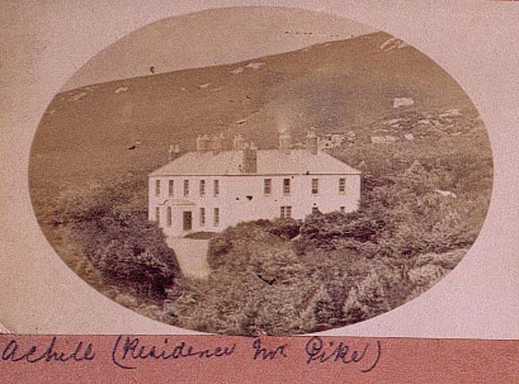
| Glendarary House | On the island of Achill, in possession of the Pike family for at least 100 years. At the time of Griffith's Valuation William Pike was leasing it from the Marquis of Sligo's estate when the house was valued at £18. |
|
| Glendollagh House | At the time of Griffith's Valuation this property was leased by John J. Strutzer from the Law Life Assurance Society and valued at £25. A house is still extant at the site. | |
| Glendoneen | Jeremiah Roberts was leasing this property to Rev. John Stoytt at the time of Griffith's Valuation, when it was valued at £45. Lewis refers to Glendoneen as the seat of Rev. J. Stoyte in 1837. It is still extant and occupied. |

|
| Glendoon | At the time of Griffith's Valuation Moses Netterfield held offices and land in the townland of Doon, Ballyconnell, county Cavan, part of the estate of the Earl of Annesley. The National Inventory of Architectural Heritage describes this building as an 'early nineteenth-century house of simple Italianate design'. |
|
| Glenduff Castle | This house was the residence of Jones Stavelly in 1814. Lewis records R.J. Stevelly as the occupier of Glanduff Castle under the parish of Newcastle and Eyre Massy under the parish of Monagay. Eyre Massy was residing at Glanduff, valued at £38, in the early 1850s. Glanduff Castle was a residence of the Ievers of Mount Ievers, county Clare, in the late 19th century as Slater notes it as a residence of James Butler Ievers. Burnt in 1922 this house is now a ruin. |

|
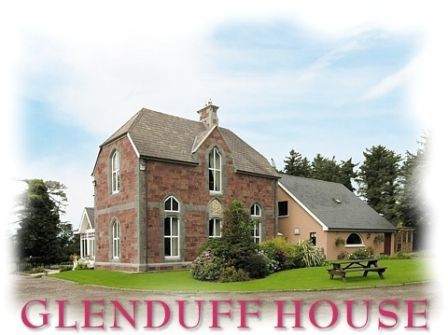
| Glenduff House | Robert Conway Hurley was leaing this property to John Hurley at the time of Griffith's Valuation, when it was valued at £5 15s. In 1906 it was the property of John C. Hurley and valued at £10 15s. Bary writes that the Hurley family owned Bridge House in Tralee but also retained Glenduff House as their country estate. The house remained in the Hurley family until it was sold in the early twentieth century. It has been extensively renovated and is now a guesthouse. |
|
| Gleneask Lodge & Cottage | At the time of Griffith's Valuation, John Brett was leasing over 500 acres and a herd's house valued at £4, from John Taaffe, at Tullaghaglas, barony of Leyny. Lewis records Glenesk, in Kilmacteige parish, as a seat of the Taaffe family, in 1837. This is Gleneask Cottage, still extant and occupied. McTernan indicates that this property was built by the Irish Waste Lands Improvement Society, when they leased the Taaffe estate in the 1830s. In 1866, when the property was offered for sale, "Gleneask House" was described as being situated in "most romantic scenery". McTernan writes that this latter property was a hunting lodge built by the Taaffes in the 1850s and demolished in the 1930s | |
| Glenefy/Gleneefy | Built for George L. Bennett by Charles Frederick Anderson see http://www.dia.ie/works/view/256 The house is named on the first Ordnance Survey map as Gleneefy but on the later 25-inch map as Glenefy. In 1837 Castlecreagh was the residence of G. Bennett and at the time of Griffith's Valuation Castlecreagh, valued at £26 was held by George L. Bennett in fee. In 1906 occupied by William H.M. Bennett and still valued at £26. It is still extant. |
|
| Glenfarne Hall | Glenfarne Hall, overlooking Lough MacNean, was built around 1820 for Charles Henry Tottenham. In 1906 it was owned by Col. J.G. Adamson and was valued at £50. It was subsequently a holiday home of Edward Harland of Harland & Wolf shipyards in Belfast. The 1943 Irish Tourist Association survey recorded that only the gutted ruins of the house remained.The area has been extensively afforested since then and is now part of a forest park owned by Coillte. |

|
| Glenfield House | In 1906 Major P. Chute owned a property at Ballygarret, barony of Corkaguiny, valued at £35 10s. At the time of Griffith's Valuation, this townland was in the possession of Nathaniel Bland. The house does not appear on the First Edition Ordnance Survery map but is labelled Glenfield House on the later 25-inch edition of the 1890s. In 1894 Slater noted it as the seat of Captain Thomas Chute. The original house is no longer extant. | |
| Glengarra | Occupied by Robert Dring in the early 1850s, valued at £25 and held from Robert Uniacke. Still extant and occupied. |
|
| Glengarriff Castle | Sarah White was leasing this property from the Bantry estate at the time of Griffith's Valuation, when it was valued at almost £36. In 1837, Lewis described it as "Glengarriff Castle, the seat of Captain White, is a spacious elegant mansion". Local sources suggest the Castle was built in the 1790s by Simon White, a brother of the 1st Earl of Bantry. Noted by Leet as the seat of Simon White in 1814. In 1894 Slater refers to it as the seat of R.H.E. White. It functioned as a resort until the 1970s. Plans are currently in progress to restore the building. |

|
| Glengarriff Lodge | Held in fee by the Earl of Bantry's estate at the time of Griffith's Valuation, when it was valued at £9. The house was a specially designed hunting lodge for the Bantry estate. It remained in the estate's ownership until the 1940s. Though badly damaged by fire in the 1960s it has been completely renovated and now serves as luxury self-catering accommodation. See www.glengarriff-lodge.com. |

|
| Glengarriff or Eccles Hotel | Thomas Eccles was leasing this property from the Earl of Bantry's estate in 1852 when it was valued at £21+. It is labelled on the 1st Edition Ordnance Survey Map as Glengarriff Hotel but is better known now as the Eccles Hotel, one of Ireland's oldest hotels. In April 1875, following the death of Thomas Eccles, the hotel was offered for sale in the Landed Estates Court. A detailed history is available at www.eccleshotel.com. |

|
| Glenglassera/Glenlossera Lodge | At the time of Griffith's Valuation held by Zachary Mudge in fee and valued at £4. In 1894 Slater refers to it as the seat of A. Mudge. Buildings still remain at the site. | |
| Glengollen | This property was held in fee by Thomas Norman at the time of Griffiths Valuation in the 1850s, when it was valued at £62. Lewis referred to it as the seat of Charles Norman in 1837. It was owned by his grandson, also Charles Norman and valued at £60 in 1906. Charles Norman was killed in the First World War. Local sources suggest the estate was acquired by the Land Commission after 1923. The house was demolished in 1937. | |
| Glenidan | Glenidan House is named on both the first edition six inch and 25 inch OS maps. Stephen Moore lived at Glenidan in 1814. Lewis records it as the residence of Blandford. Robert McCormick held Glenidan, valued at £10.10 from Patrick E Murphy at the time of Griffith’s Valuation (publ. 1854). This house appears to be still extant. | |
| Glenlicky Mill | At the time of Griffith's Valuaton Rev. James Elliott was leasing this substantial property to Thomas Page, when it was valued at £44. It included a house and mill. Noted on the 25-inch Ordnance Survey Map of the later nineteenth century as Glenlicky Mill. The buildings are now ruinous. | |
| Glenlo | A house called Kentville was occupied by the Martin family in the late 18th century though Wilson mentions a Mr. Irwin living there in 1786. By 1824 Thomas Redington was occupying Glenlo, which became the home of Thomas Blake in the mid 19th century and of the Palmers in the late 19th century. Now functions as a hotel. |
|
| Glenmore | At the time of the first Ordnance Survey Glenmore was occupied by the Rev St George Knox, curate of Crossmolina, as the Ormes were living in Dublin. Glenmore became the property of Godfrey Fetherstonhaugh after the 1853 sale. His mother was an Orme of Abbeytown. Well maintained and owned by a French family who advertised the sale of the house in September 2006. |
|
| Glenmore (Moydow) | Noble Armstrong was leasing this property from the King Harman estate at the time of Griffiths Valuation, when it was valued at almost £12. Both Lewis in 1837 and Leet in 1814 referred to it as the seat of Newcomen Armstrong. It is extant but disused. |
|
| Glenmore (Raphoe South) | William Style held this property in fee at the time of Griffiths Valuation in the 1850s, when it was valued at £30. It is labelled Glenmore on all editions of the Ordnance Survey maps. In 1837 Lewis referred to Glenmore as the seat of C. Style. In 1906 it was owned by Sir F.M. Style and valued at £82. The National Inventory of Architectural Heritage suggest it was built in the later eighteenth century and demolished c.2000. |
|
| Glenmore House (Lismore) | At the time of Griffith's Valuation, Thomas Boyce was leasing this property to Richard Cliffe, when it was valued at £24. A very substantial farmyard is labelled at this site on the 1st edition Ordnance Survey Map. It is labelled Glenmore House on the later 25-inch edition. It is still extant and occupied. |
|
| Glennagloughaun North | A building valued at £12 was occupied by Digby French at the time of Griffith's Valuation, this may have been the old charter school marked on the first Ordnance Survey map. The latter building appears to have fallen into disuse by the 1890s and the site is now occupied by a farm supply stores. | |
| Glenomera | Glenomera was the seat of the Arthur family from the mid 17th century until the early 20th century. In 1786, Wilson refers to Ballyquin as "the fine seat of Mr. Arthur". It is labelled Ballyquin House on the 1st edtion Ordnance Survey map but as Glenomera on the later 25-inch edition. Lewis wrote in 1837 that Glenomera was "celebrated as a shooting station for grouse and pheasant". It was held in fee by Thomas Arthur at the time of Griffith's Valuation and valued at £35. The house is now demolished. | |
| Glenown/Clonown | Clonown is named on the first edition OS map. It is a three-bay two-storey over basement house, built c.1815 now known as Glenown (boi). At the time of Griffith’s Valuation (publ. 1854) Richard Fitzgerald was resident, holding the house valued at £18 in fee. In the mid-1870s his son Captain James is recorded at Clonown. |
|
| Glenshelane Cottage | Leased by Sir Richard Keane to John Keane in 1851 when it was valued at £14. The 1855 sale notice describes it as "a handsome cottage". Later in the possession of Justin Deane Freeman and leased to Thomas Haly. Offerd for sale in the Landed Estates Court in February 1864, when the owner was Charles St. John Herbert and the petitioner, Maria Deane Freeman. The house is still extant and occupied. |

|
| Glenstal | Described by Bence Jones as a "massive Norman-Revival castle", built for the Barrington family. The building began in 1837 but was not completed until the 1880s. Noted by Slater as the seat of Sir Charles Burton Barrington in 1894. The buildings were valued at £65 in the early 1850s and at £58 in 1906. Now known as Glenstal Abbey, it is a boys' boarding school run by the Benedictine monks, who bought the property from the Barringtons in 1927. |

|
| Glenstown | Leased by Johanna Cormack from Lord Waterford's estate in 1850 when it was valued at almost £14. A farm exists at the site now. | |
| Glenturk Lodge | Noone writes that this lodge was built circa 1860 and was also known as Glencullen Lodge. | |
| Glenveagh Castle | Glenveagh Castle was built c.1867 by John George Adair. The townland of Gartan Mountain, in which the castle is located, was the property of Samuel Marshall at the time of Griffiths Valuation. Following Adair's death in 1885 his wife Cornelia continued to maintain the castle until the early twentieth century. In 1929 it was purchased by Arthur Kingsley Porter, a Yale professor of art who mysteriously disappeared in 1933. It was later owned by Henry McIlhenny of Philadelphia who sold the estate to the Office of Public Works in 1975. It now forms part of Glenveagh National Park. |
|
| Glenview | Glenview was occupied by the Reverend Edmund Prendergast in the early 1850s. He held the house valued at £18.15 shillings from Matthew Prendergast. In the early 20th century the house was altered and extended by a religious order who set up a school. |
|
| Glenview | George Courtenay is recorded as resident at Glen-View in 1814 and also in the early 1850s when he held the property from James H. Smith Barry. The buildings were valued at £9. In 2010 it was offered for sale. |
|
| Glenview | Samuel Levis was leasing this property from the Becher estate at the time of Griffith's Valuation, when it was valued at £18 10s. A house still exists at the site. | |
| Glenview (Drumlane) | Glenview House was built in the 1840s or 1850s. Captain Michael Phillips owned and occupied it and it had a rateable valuation of £11.10.0. Home of the Ebbitt family at the beginning of the 20th century but no longer extant. | |
| Glenview (Stradbally) | At the time of Griffith's Valuation, Rev. Thomas Drought was leasing a property valued at £14 from Frederick Carter. This may be the house which afterwards became known as Glenview. It is still extant and well maintained. |
|
| Glenview Cottage | In 1786 Wilson refers to a house in the vicinity of Egmont as "Glenfield", the seat of Mr. Wrixon. This may be the property marked on the 1st edition Ordnance Survey map as Glenview Cottage. At the time of Griffith's Valuation, this house was leased by Daniel Murphy from the Egmont estate and valued at £10. A house is still extant at the site. | |
| Glenview {?}/Comeragh-house B | In 1851, Rev. William Ardagh was leasing a property adjacent to Comeragh House from the Palliser estate when it was valued at almost £10. A house and farm buildings are still extant at the site. Walford gives Rev. Ardagh's address as Glenview which may refer to this house. | |
| Glenview/Glenamara | This house is labelled on the 25-inch Ordnance Survey Map of the 1890s as Glenview. It is possibly the property leased by Rev. Thomas Drought from Frederick Carter at the time of Griffith's Valuation when it was valued at £14. It seems to have become known as Glenamara in the twentieth century during which time it came into the possession of the Spring-Rice family who offered it for sale in 2011. |
|
| Glenville | In 1848 John Greene was leasing this property from the Power estate when it was valued at £46. | |
| Glenville | Originally a Coppinger property sold to the Hudsons in the mid to late 18th century. The Hudsons built a new house and this house was added too in 1887. E. G. Hudson was resident at Glenville in 1814 and Lewis records the Reverend E. G. Hudson as the proprietor of Mount Pleasant in the parish of Ardnageehy in 1837. In the mid 19th century William E. Hudson held the property valued at £46 in fee. Inherited by William E. Hudson's nephew Sir Edward Hudson Kinahan who was the occupier in 1906 when the house was valued at £150. Sold to the Bence Jones family in 1949. Also known as Mount Prospect and The Manor, this house was the home of Mark Bence Jones, author. |
|
| Glenville | Richard Robinson was leasing this property to Nicholas Bowen at the time of Griffith's Valuation, when it was valued at £11. In 1837, Lewis noted it as the seat of R.B. Robinson. It is now a farm guesthouse. |
|
| Glenville | At the time of Griffith's Valuation Mary Allen occupied Glenvillle, a house valued then at £8. The property was held from the Earl of Egmont. Catherine Cooke daughter of William Allen of Glenville married John Bevan of Camas in 1856. Hajba writes that Glenville belonged to Massy Bevan in the late 19th century. The house was restored in the 20th century and is occupied. |

|
| Glenville | The Earl of Clancarty was leasing a house valued at £12 in Cahercrea East to Margaret Daly in 1855. This house is still extant and now known as Glenville. In the adjoining townland of Ballycoony Clancarty was leasing a house valued at £4 as well as 118 acres to John Hardy. |
|
| Glenville | The Massys lived at Glenville from the 1760s. The present house was built by William Massy in 1808. William Massey was resident in 1814, J. Massey in 1837 and William Massy in the early 1850s. William Massy held the house valued at almost £14 from Stephen Creagh. The house came into the possession of the Langford family, relations of the Massys in the early 20th century and they were still resident there in the 1970s. |
|
| Glenville Cottage (Gaultiere) | At the time of Griffith's Valuation, this property was occupied by Captain P.C. Lamphiere, leasing from the Fitzgerald estate. It was valued at £17 at the time. It is labelled Glenville Cottage on the 25-inch Ordnance Survey Map of the 1890s but as Cove Cottage on the 1940s edition. A house is still extant at the site. | |
| Glenwilliam | A house built in 1797 by the Reverend William Massy, second son of the Reverend Godfrey Massy. Occupied by George Massy in 1814. The residence of Mary Anne Massy at the time of Griffith's Valuation, held from the Court of Chancery and valued at £38. In the later 19th century it was the home of the Atkinson family. Slater noted it as the seat of Thomas D. Atkinson in 1894. This house is still extant and occupied. |

|
| Glenwilliam | The residence of James Blake Butler in 1837. Occupied by John McNamara in the early 1850s and held from Lord Fitzgerald and Vesci when it was valued at almost £5. Still extant and occupied. | |
| Glenwilliam (Decies) | In 1851, Reverend Garrett Prendergast was leasing this property from Richard Fuge, when it was valued at £15. Local sources suggest Reverend Prendergast was the parish priest of Ardmore during and after the Famine. A house and substantial farm still exist at Glenwilliam. | |
| Glenwood | Marked on the first Ordnance Survey map this house was occupied and held in fee by - Teulon at the time of Griffith's Valuation, when the buildings were valued at £23. By 1906 Glenwood valued at £33 was occupied by A. C. Fleury, a minor. In the 1940s the Irish Tourist Association survey noted that it was then the home of Mrs.Pennefather, "mother of the famous artist, who came to live here about twenty years ago". Glenwood is still extant. |
|
| Glenwood | Weir records Poole Gabbett in residence in 1810, Basil Davoren occupied the house in 1837 and John Gabbett at the time of Griffith's Valuation. He held it from George Studdert and it was valued at £10. Alice Studdert married General Frederick Maunsell and they lived at Glenwood which passed to their son Robert Maunsell. This house was the scene of an ambush in which eight Black and Tans were killed in 1920. The house no longer exists. | |
| Glenwood Lodge | Richard Harding Wigmore occupied a house, flour mill and lodge valued at £30 at this location in the mid 19th century. He held the property from Henry Wigmore. | |
| Glin Castle | The home of the Knights of Glin, built in the 1780s and later castellated, it is situated on the Shannon estuary. Wilson refers to it in 1786 as" Glyn House, the pleasant seat of Mr. Fitzgerald". In the early 1850s it was valued at £50. The castle is still in the possession of the family but in 2015 was offered for sale. |
|
| Glinny House | George Dunne was leasing Glinny House from Thomas Daunt at the time of Griffith's Valuation, when it was valued at £25. Lewis refers to it as the seat of G.N. Dunne in 1837. The Daunt family also owned Glinny Cottage [W669595] in the same townland, then valued at £8 and occupied by Elizabeth Walsh. Though altered Glinny House is still extant. |
|
| Glinsk House | In 1786 Wilson refers to Glinsk as the "seat of the late Sir John Burke" and also as the seat of Sir Rickby Burke. Glinsk Castle and a substanial house are both marked on the 1838 Ordnance Survey map. The castle is shown on the 25-inch map of the 1890s but there is no trace of the house. At the time of Griffith's Valuation, Allen Pollok held buildings valued at £1 15 at the site, recorded as a herd's house. | |
| Gloves (Athenry) | The Ordnance Survey Name Books record Gloves as the residence of Mr. Browne in the 1830s. At the time of Griffith's Valuation Mark Loughnane held the townland of Gloves Middle, barony of Athenry including buildings valued at almost £8. By 1906 Michael J. Monaghan was the owner of this property. Buildings are still extant at the site. | |
| Glynch/Glinch House | Glinch Lodge is marked on the 1st edition Ordnance Survey map (1836). Sources in the National Library record the will of J. Rogers of Glinch Lodge, 1827. Lewis records J. Thompson as the occupant in the late 1830s. A new house with portico entrance was built slightly to the south in the mid-19th century and valued at £50 in Griffith’s Valuation. It was occupied by Robert Lowry and held from Richard Mayne. At some time in the mid-19th century ‘Glynch’ House was the residence of Charles Stuart Adams who married Eliza McMahon of Rockfield, county Monaghan in 1850. Home of Felix Keirns and his family in 1911. |

|
| Glyntown House | Unoccupied in the early 1850s, this house was held by Eliza McCaul from William B. Hoare. It was valued at £35. Bence Jones writes that this house, now demolished, was built by Samuel McCall and was owned in the 20th century by the Dring family. | |
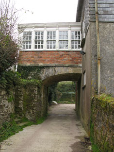
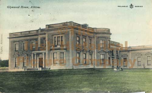
| Glynwood House | Glynwood house is located east of Athlone. The original house was constructed about 1790 by Francis Longworth and rebuilt about 1860 by John Longworth (1798-1881). A new house in the Italianate style was built in the early 1880s for Francis Travers Dames Longworth to the design of George Moyers. On 1 February 1918, a few lines in the Belfast News-Letter stated that Glynwood House, Athlone, the family mansion of the Dames-Longworth family, had been destroyed by fire. It is now an ivy covered ruin. See https://houseandheritage.org/2018/02/01/glynwood-house/ The present Glynwood House, formerly the agent’s house is located to the northwest of the site of the original Glynnwood House and dates from the late 19th century. |
|
| Gola | Built in 1703 by Joseph Wright son of James Wright and his second wife Mary Slacke (www.thesilverbowl.com). It was the home of the Wright later Woodwright family in the 18th and 19th centuries. At the time of Griffith’s Valuation the Reverend William E. H. Woodwright was resident. The buildings were valued at £25. In 1901, Patrick Callaghan, steward, was resident in Gola. Sir John Banks (1815-1908) was the proprietor. He was a well-known Dublin physican who had married in 1848 Alice Woodwright. Their only child Mary married Willoughby Burrell 4th Baron Gwydyr in 1873. On 25 February 1921 Gola was burnt and subsequently demolished. | |
| Golden Bush | A house located between Inishannon and Kinsale which was in the possession of the Wilmot family in the 1770s and 1780s. In 1814 Leet noted it as the seat of William H. Herrick and it was occupied by Thomas Herrick at the time of Griffith's Valuation when it was valued at £5. Gibson had noted it as the residence of Henry Sheares in the 1760s. | |
| Golden Hills | Leet records Henry White as the proprietor of Goldenville, Golden, in 1814. In 1837 Lewis refers to Golden Hills as the "castellated residence of H. White". Edmond [Edward] Dalton occupied this house in the early 1850s holding it from Henry White. It was valued at £25. By 1858 Thomas Judkin Fitzgerald was occupying Golden Hills or Golden Lodge which was advertised for sale in January 1858 and again in April 1878. In 1878 Golden Hills was described as a "large castellated building" with a drawing room opening into a conservatory, dining room and morning room, 8 bedrooms and a servants' hall. The Irish Tourist Association surveyor records that it was the residence of Thomas Judkin Fitzgerald, High Sheriff of county Tipperary in 1798, known as "Flogging Fitzgerald". In the early 1940s most of the house had disappeared or was incorporated into a modern farmyard. |

|
| Goleen House | At the time of Griffith's Valuation, Alicia Notter was leasing this property to Jeremiah McCarthy, when it was valued at £7. In 1837 Lewis had noted it as the seat of J. McCarthy. [Grid Reference is approximate] | |
| Goolamore Lodge | Described at the time of the first Ordnance Survey as "a new two storey house occupied by Mr Gallagher who rented the salmon fishery". It was leased by John Walsh to Patrick McAndrew at the time of Griffith's Valuation. It is no longer extant. | |
| Gooldshill | At the time of Griffith's Valuation Henry Goold was leasing land in the parish of Mallow to Michael Jones. Gooldshill was occupied by Edmund Roche who held the house and 7 acres from Michael Jones. The buildings were valued at £12. Hajba writes that this house is now derelict. | |
| Goorey Lodge | Lewis refers to Goorey Lodge as the seat of John Harvey in 1837. At the time of Griffiths Valuation in the 1850s, the property was valued at £5 and occupied by John Harvey. The valuation describes him as "John Harvey of Goorey Lodge" to distinguish him from his cousin, John Harvey of Malin Hall. | |
| Gore Port [Derrymacegan] | In the 1850s Captain Alexander Walker was leasing this property from the Gore estate when it was valued at £15. It is labelled Derrymacegan on the 1st edition OS map but as Gore Port on subsequent editions. The National Inventory of Architectural Heritage suggests the earlier part of the property dates from the mid 18th century and the later part from the early 19th century. O'Brien suggests that it was Captain Walker who built the later building, c.1835. Sir Samuel Walker, Lord Chancellor of Ireland, 1892-95, was born at Gort Port in 1832. The house is still extant. | |
| Gort | A home of the O'Kellys in the mid 18th century. Occupied by "Doyle esquire" in 1778 and 1786 and by Simon J. Dowell in 1814. The house is labelled Gort on the 1st edition Ordnance Survey map but is not named on the 25-inch edition of the 1890s. The townland was in the possession of Elizabeth Dowell at the time of Griffith's Valuation when she was leasing a house valued at £4 10s to Michael Kelly. Some ruins exist at the site now. | |
| Gort House | Margaret O'Brien was leasing a house valued at £15 in the townland of Gortnalamph from the Clements estate in the 1850s. Gort House is still extant and occupied. |
|
| Gort House (Inishowen) | Andrew S. Hamilton was leasing this property from the Norman estate at the time of Griffiths Valuation in the 1850s, when it was valued at almost £14. A house is extant at this site. | |
| Gortaglanna House | At the time of Griffith's Valuation, Hibernicus Scott senior was leasing this property to Hibernicus Scott, junior, when it was valued at £34 10s. Lewis records it as the seat of Maj. M. Scott in 1837. It is still extant and occupied. |
|
| Gortaha House | Cuthbert Featherston held a property valued at £10 in the townland of Gortaha, parish of Lickmolassy, barony of Longford, in 1856. It is labelled Gortaha House on the 1st edition Ordnance Survey Map. The 25-inch map of the 1890s records that it was "in ruins" and very little now remains. | |
| Gortahilly | William Power was leasing this property from Lord Fortescue's estate in 1848 when it was valued at over £16. A farm still occupies the site. | |
| Gortahorna House | Mrs. Eliza Sealy held this property in fee at the time of Griffith's Valuation when it was valued at £32. Lewis notes it as the seat of J.M. Sealy in 1837. In 1906 it was owned by John Hungerford Sealy when buildings were valued at £8. . A nearby flour mills, named Barleyfield Mills, [W508485], was leased to William Sullivan and valued at £13. In 1942 the Irish Tourist Association Survey noted that it had bee rebuilt after being burnt but by the 1940s the roof had been removed "and the slates used for housing schemes". The house is now a ruin. The mill continued to be worked until the mid-twentieth century and the building is still extant. |
|
| Gortakeeran | John A. Daly owned buildings valued at almost £8 at Gortakeeran in 1906. At the time of Griffith's Valuation this townland was owned by John B. Daly including a herd's house valued at 15s. | |
| Gortanimill House | In the mid 19th century this house was the residence of Herbert Baldwin MD and held by him in fee, valued at £24. It was included in the proposed sale of Herbert Baldwin O'Sullivan's estate in 1889 when the sale notice described it as "an excellent residence in very good repair". In 1944 the Irish Tourist Association survey refers to it as "formerly the residence of Dr. Baldwin, now occupied by Mr. Lynch, NT" This house is now demolished. |