Browse Houses
Search Results: Returned 5927 records. Displaying results 2701 – 2800
| House name | Description | |
|---|---|---|
| Gallanagh House | Gallanagh House, located just north west of Monaghan town, is named on the 1st edition 6 inch Ordnance Survey map (1836). At the time of Griffith’s Valuation circa 1860 it was occupied by William Watson and held from James Hamilton of Cornacassa. The buildings were valued at £36. This house appears to have been unoccupied in 1901 and the home of Ernest P. Tyacke, County Inspector Royal Irish Constabulary, in 1911. Tyacke held the property from William Swan. A William Swan was proprietor of the newspaper ‘The Northern Standard’, Monaghan. A large complex of buildings [poultry factory] now occupies the site. | |
| Gallow's Hill | Occupied by James Simpson at the time of Griffith's Valuation when the buildings were valued at £20 and leased from the Earl of Lucan's estate. On the 1st edition Ordnance Survey map the name "Gallowshill" is attached to linear set of structures set out in small plots. This has disappeared by the 25-inch edition map of the 1890s and the substantial structure leased by Simpson is located some distance away. The site of this is now almost completely overgrown. | |
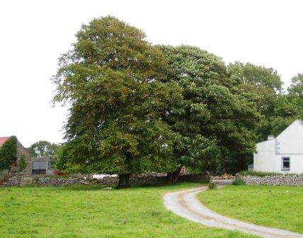
| Gallowshill | A house built for the St George family at the end of the eighteenth century but used as a hospital for the Carrick-on-Shannon area until the 1940s. |
|
| Gallstown | Gallstown/Gaulstown House was a large country house with extensive grounds as shown on the first edition OS map on which the house is named as Castletown, although the Taylor and Skinner map of the late 1770s refer to the house as Gaulstown Park. Its name changed to Gallstown House on the 25 inch map. It was an 18th century, three storey, seven-bay Palladian style house built by the 2nd Earl of Belvedere to replace the house in which his mother was imprisoned for over thirty years. In 1784 Sir John Browne of The Neale, Co Mayo, later 1st Baron Kilmaine, purchased the house from the 2nd Earl of Belvedere. Lord Kilmaine was recorded as resident in 1814, 1837 and at the time of Griffith’s Valuation (publ. 1854). Lewis refers to Gaulstown Park as the ‘splendid seat of Lord Kilmaine in the grounds of which is a very large larch tree, planted by Dean Swift’. The house was valued at £66 in the mid-19th century. O’Brien writes that the 5th Baron Kilmaine sold the house at Gallstown in 1918 and it was burnt in 1921 and the ruins demolished in the 1950s. | |
| Galtee Castle | Built in the late 18th century as a hunting lodge, it was described in the Kingston sale rental of July 1851 as a "handsome cut stone building, erected in a tasteful style of architecture, with suitable offices .... beautifully situated in the curve of a well planted glen..". Located close to the eastern bank of the Attychraan River at the base of the southern slope of the Galty Mountains, this house was occupied by James Law in the mid 19th century, valued at £29+ and held by him in fee. Noted by Slater in 1894 as the home of Nathaniel Buckley and of Abel Buckley in 1906 when the buildings were valued at £130. The house is no longer extant. Also known as Mountain Lodge. | |
| Gammahoe Cottage | A smaller property on the Persse estate, possibly a steward's house, with 257 acres in 1855. There is no trace of a house at this location now although there is some evidence of farm buildings and garden walls. | |
| Garadice | John Percy was leasing the house at Garadice, barony of Carrigallen, from the representatives of William Percy at the time of Griffith's Valuation when it was valued at £15. In 1814 it was noted as a residence of the Percy family. Lewis records it as the seat of W.C. Percy in 1837. In the 1780s both Taylor and Skinner and Wilson noted Garadice as a Percy residence. The ITA survey recorded it as much deteriorated in the 1940s. It also mentions the existence of a second house belonging to the Percy family in the townland of Carrickmakeegan. The buildings are still extant at Garadice. | |
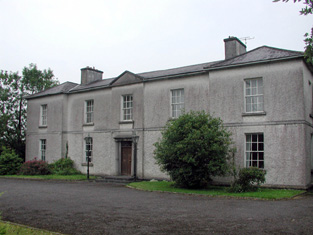
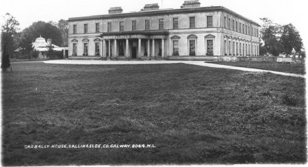
| Garbally Park | In 1783 Taylor and Skinner show Garbally as a seat of the Trench family. Wilson mentions Garbally , "the very fine seat of Willaim Power Keating Trench", in 1786. At the time of Griffith's Valuation it was the seat of the Earl of Clancarty and was valued at £150. It became St. Joseph's College, Garbally Park, in 1922 and has functioned as a school until very recently. It is still extant. |
|
| Gardenfield | Home of a branch of the Kirwan family from the late 18th century to the mid 20th century. The original house was replaced by the present house circa 1870. Following the death of Edward Kirwan the estate was divided by the Land Commission in the 1950s. Gardenfield House is now a bed and breakfast. http://www.corrib.net/BedBC14.htm |
|
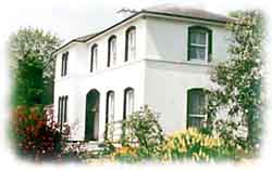
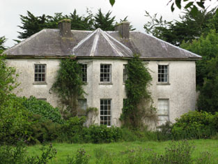
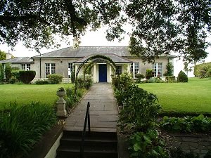
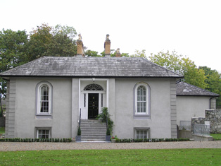
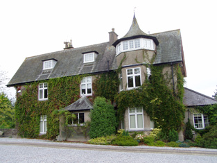
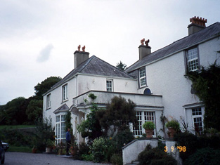
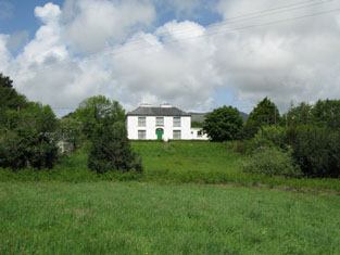
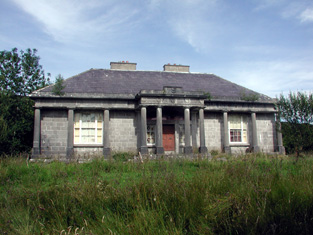
| Gardenfield House [Kilcommon] | Another Bowen home, occupied by William Bowen in 1814. The townland was in the possession of Henry Martin Blake at the time of Griffith's Valuation. It is labelled Gardenfield House on the 25-inch edition Ordnance Survey map of the 1890s. Still a family home, renovated in the early 21st century. |
![Photo of Gardenfield House [Kilcommon]](https://landedestates.ie/storage/img/orig/731.jpg)
|
| Gardenhill | ||
| Gardenhill House | The original Gardenhill House, home of the Blackall family, was by the time of the first edition Ordnance Survey map, circa 1840, "in ruins". The present house dates from after 1840 and is located at R675 613. |

|
| Gardenmorris | Held in fee by John P. O'Shea at the time of Griffith's Valuation, when it was valued at £56. It was also noted by Lewis as his residence in 1837. Smith referred to it as the house of Mr. Richard Power in 1774. Noted by Slater as the residence of Nicholas Power O'Shee in 1894 and owned by Richard P. O'Shee and valued at £57 in 1906. The house was totally reconstructed following its burning during the Civil War in 1922. The ITA survey in 1942 noted that most of the library and works of art in the house were destroyed at that time. It is still extant and occupied. |

|
| Gardeville | Noted by Lewis in 1837 as the seat of Rev. W. Hall. Leased by Sarah Hosford from the Devonshire estate in 1851 when it was valued at £13. | |
| Garland Cottage | Occupied by Anne Davis and held from Henry Braddle at the time of Griffith's Valuation. The buildings were valued at £25. Hajba writes that it was the home of the Davis family for most of the 19th century. Bought by James John Dudley in the 20th century, father in law to Erskine Childers, President of Ireland. |
|
| Garnavilla | A branch of the Nagle family lived at Garnavilla in the 18th century. They held it on a lease from Lord Caher. James Archer Butler was the occupant of this house in 1837 and in the early 1850s when the house was valued at £21 and held from the Earl of Glengall. A building is still extant at this location. | |
| Garracloon | Wilson refers to Garracloon as the seat of Mr. Blake in 1786. In 1814 the house was occupied by the Reverend Cecil Crampton, rector of the parish of Cong. At the time of the first Ordnance Survey in 1838 Garracloon house was recorded as a ruin. At the time of Griffith's Valuation, it was held in fee by Joseph Blake and valued at £8. The house was later rebuilt, Ruane refers to the ruined Victorian Garracloon House. Sir William Wilde refers to Colonel Veitch at Garracloon. No longer extant but yard buildings remain. |
|
| Garrahies | At the time of Griffith’s Valuation, this property, valued at £11, was being leased by Edward Day to Francis Fitzgerald. In 1837 Lewis records it as the seat of F. Fitzgerald. Bary states that it remained in the Fitzgerald family until the 1930s. It was still extant in the late twentieth century. | |
| Garrancloyne House | This was the original home of the Coppingers of Middleton. A substantial house with a gate lodge is marked on the first Ordnance Survey map but by the time of Griffith's Valuation the house with the largest valuation in this townland was £2. It was occupied by Hughes Martin and held from William Coppinger.In 1786 Wilson refers to "Killycloyne" as a seat of the Martin family in this area. | |
| Garrane | A house located on the Wyse Minors estate in the mid 19th century, occupied by Margaret Hartigan and valued at £11+. This house is barely marked on the first Ordnance Survey map. | |
| Garrane | In the early 1850s Francis Hennis occupied a house valued at £30 from William Howe Hennis. A building still exists at this site. | |
| Garrane House | This house is not marked on the first Ordnance Survey map. By the time of Griffith's Valuation however Henry Justice occupied a house valued at £11.10 shillings at Garrane West. He held the property from John C. Wallace [Wallis]. The home of members of the Twomey and O'Keeffe families in the 20th century and still occupied. | |
| Garranereagh House | Sidney Howe was leasing this property to Catherine Stawell as the time of Griffith's Valuation, when it was valued at £9. A house is still extant at this site. | |
| Garranes (Templemartin) | In 1837 Lewis describes Garranes as "a newly erected and handsome house, near the old family mansion, the residence of J. Splaine". At the time of Griffith's Valuation, it was held by James Splaine from the Duke of Devonshire's estate and valued at £28. It is still extant. |
|
| Garranes House | Leased by James Splaine from the Devonshire estate in 1851 when it was valued at £28. Described by Lewis in 1837 as a "newly erected and handsome house, near the old family mansion, the residence of J. Splaine". |

|
| Garrangibbon | This house known as South Lodge was occupied by J.B. Elliott in 1814. The Ordnance Survey Name Books describe it as "handsomely situated....with garden plantation and planted ornamental grounds" in 1840. It was occupied by Richard C. Jackson who held the house valued at £14 from the representatives of Mrs R. Hartford in the mid 19th century. Some alterations to the house have taken place in more recent times and it still functions as a country residence. |

|
| Garranlea | A Keating home from the 18th century, occupied by Leonard Keating in the first half of the 19th century. In 1800 Leonard Keating married Lucinda Scully of Kilfeacle. Their son, Robert, was Member of Parliament for county Waterford in the late 1840s. In 1850 he held the property from the Earl of Clonmel and the buildings were valued at £34+. This house no longer exists. | |
| Garraun | In the early 1850 John O'Meagher occupied a steward's house at Garraun which he held from - Stratford. The buildings were valued at £12+. A farming enterprise is still located at this site. | |
| Garraun | George C. Stawell held this property from Sir George Colthurst at the time of Griffith's Valuation. The buildings were valued at £7.10 shillings. This house was still occupied by the Stawells in the 1870s. A house and farm are still extant at the site. | |
| Garraunbaun | Built by Charles Palmer Archer in the 1850s, it later became the home of the Duane family. Home of the Lavelle family in the 1930s who sold it to Colonel Alfred Irwin. Restored and renovated by the present owner Neil O'Donohue in 2005. |
|
| Garrettstown | In 1851 John Cuthbert Kearney held this property in fee when it was valued at £80. In the 1870s this house was the home of Abram T. Forster. The Forsters and the Cuthbert Kearneys were related. By the early 20th century Garrettstown had passed into the possession of the Franks family throught the marriage of Thomas Franks of Dromrahane, Mallow and Mary Anne Cuthbert Kearney in 1834. Though the main house is ruinous the site is now the focus of Garrettstown Holiday Park, see www.garrettstownhouse.com. |

|
| Garriestown | This was a Walsh family home in the 19th century. At the time of Griffith's Valuation the house was leased by Thomas Walsh from Robert Rutledge when it was valued at £11. Garriestown is now a large farming enterprise and the house is still lived in. |
|
| Garroman Lodge | Built by Dean Mahon of Westport in 1833 [James Mahon of the Castlegar family, Dean of Dromore] and its situation is described by Robert Graham in his journal of September 1836. At the time of Griffith's Valuation it was leased by Patrick Larkin from the Law Life Assurance Society and valued at £1. The Berridge family later used it as a shooting lodge. The house no longer exists. | |
| Garruragh House | In 1786 Wilson refers to "Garuragh" as the seat of Mr. Harrison. At the time of Griffith's Valuation, the house was part of the O'Callaghan estate but leased to the Tulla Board of Guardians as an auxiliary workhouse when the buildings were valued at £48. It is labelled Garruragh House on both the 1st edition and 25-inch edition Ordnance Survey maps though much of the buildings have disappeared by the 1890s and only some ruins remain now. | |
| Garryard | Thomas Dillane was leasing this property from the Mahony estate at the time of Griffith's Valuation, when it was valued at £5 10s. Bary states that the house is alleged to be over 300 years old and originally the property of the Newman family. In the eighteenth and early nineteenth century it was held by the Enright family and later passed to the Bolster family through marriage. It served as an auxilliary work house during the Famine and was also the location of the local creamery. It is still extant and occupied. | |
| Garrycloyne | Leet records Robert McCarthy occupying Garrycloyne in 1814. "Burkes Irish Family Records" states that Garrycloyne Castle was acquired by Samuel Philip Townshend from John Travers in 1837. The buildings were valued at £45 in the early 1850s and held by Samuel Townsend in fee. The house was later the home of the Barrys. In the 1940s the roof was taken off the house and it has remained a ruin ever since. | |
| Garryduff | This house was the residence of David Hayes in 1814. At the time of Griffith's Valuation it was occupied by the representatives of William Leake [a Limerick solicitor], who held the property from Robert Maunsell. The buildings were valued at £10+. Recorded as untenanted at the time of the sale in 1853, a lithograph of the house is included in the sale rental. | |
| Garryduff House | Garryduff was held in fee by Thomas Garde at the time of Griffith's Valuation, when the buildings were valued at £35 10s. Lewis refers to it as the seat of H. Garde in 1837. This house is no longer extant. | |
| Garryhankardmore | Mary Nash and Howard Wiseman were leasing this property to Robert Biggs at the time of Griffith's Valuation when it was valued at £35. In 1837 Lewis referred to as the seat of T. Biggs. There are still extant buildings at the site. | |
| Garrykennedy | In 1786 Wilson refers to Garry-Kennedy as the seat of Mr. Watson. Lewis refers to the houses of G. Watson and - Kent at Garrykennedy. Two houses are marked in the townland on the first edition Ordnance Survey map Garrykennedy and Shannon ville. The Ordnance Survey Name Books describe Garrykennedy as "a good dwelling house, the residence of James Watson". It was bought by William Parker in 1857. By 1906 a mansion house valued at £25+ was located at Garrykennedy. It was occupied by Robert G. Parker. The building known as Garrykennedy House had been expanded and is marked on later maps. | |
| Garryland | Garryland was an extensive wooded area, part of the Shawe-Taylor estate in the parish of Kilmacduagh, barony of Kiltartan. At the time of Griffith's Valuation and also in 1906 buildings to the value of £10, including a wood-ranger's house, were located here. These buildings are now in ruins but substantial areas of woodland remain and are now maintained by the Forestry and Wildlife Service. | |
| Garryroan House | Robert Fennell occupied this house in 1814 and Joseph R. Fennell at the time of Griffith's Valuation, when the buildings were valued at £14 and held from Lord Waterpark. This was still a Fennell home in the 1870s and continues to be a family residence. In 2012 it was offered for sale. |

|
| Garryspillane House | A mansion house valued at £16.15 shillings was located in this townland in 1906. It was occupied by Stafford Delmege, second son of the Reverend John Delmege, whose representatives owned 525 acres in county Limerick in the 1870s. A house labelled Garryspillane House is shown on the 25-inch Ordnance Survey Map of the 1890s. There is still an extant house at the site. | |
| Gartinadress House | In 1814, Charles Veaitch was the resident at Gortin-ardrass. This house is named on the first edition six inch Ordnance Survey map (publ. 1837). Although having advertised Gartinardress for sale in 1850 William Young was the owner and occupier at the time of Griffith’s Valuation when the property was valued at £15 for rates. By the early 20th century the Armstrong family were occupying Gartinardress, although in 1906 William A. K. Young is recorded as occupier of 228 acres of untenanted land and the mansion house. This house is no longer extant and the site is part of a forestry area. A house known as Lakeville was also located in the townland of Gartinardress. Leases in the National Library record Lakeville as the home of Richard Young in the 1820s. It was described as ‘in ruins’ on the 25 inch map. | |
| Gartlandstown House | Gartlandstown House, located at the south eastern toe of Lough Derravargh, is a five-bay two-storey house, built about 1830 (boi) or perhaps replacing an earlier house as Garlandstown, Castlepollard, was the seat of Sterne Tighe in 1814. By 1837 J Murray was resident here and James Murray is recorded as the occupant at the time of Griffith’s Valuation (publ. 1854) when the house was valued at £10 and held from James W M Berry. O’Brien writes that Michael Hope was resident in 1869 and in the mid-1870s the representatives of Michael Hope held 487 acres at Gartlandstown. Members of the Hope family was still in occupation at the time of the 1901 and 1911 censuses. |
|
| Garvagh House | At the time of Griffiths Valuation in the 1850s, Robert Grier held this property in fee, when it was valued at £20. In 1837, Lewis had referred to “Lakeview” as the seat of R. Grier. In 1906 James Wilson was recorded as the owner and the property was still valued at £20. It was later demolished. | |
| Gaulstown House (Fore) | The National Inventory of Architectural Heritage suggests this house was built about 1730. At the time of Griffiths Valuation it was occupied by Andrew Mulligan, leasing from Hubert de Burgh’s estate, when it was valued at £21. It had previously been the seat of the Lill family who had succeeded to de Burgh property and adopted that surname. The house is labelled Gaulstown on the 25-inch Ordnance Survey map. It is still extant. |
|
| Gaultiere Lodge | In 1848 Gaultiere Lodge was leased by the Earl of Huntingdon from Lord Carew's estate when it was valued at over £33. It is still extent and operates as a luxury guesthouse. |
|
| Gawsworth | In the mid 19th century this house valued at £19 was occupied by Russell Fitton and held from the representatives of Robert Hedges and Mr Pratt. | |
| Gaybrook House | This house was built on land originally belonging to the Gay family who sold it to Ralph Smyth before the end of the 18th century. Smyth built the three-storey three-bay house which had extensive outbuildings and pleasure grounds as shown on the first edition OS map. Leet records him as the occupant in 1814 and his widow Mrs A Smyth was resident in 1837. Their son Robert was the occupant at the time of Griffith’s Valuation (publ. 1854) holding the house valued at £95 in fee. Col James Smyth and family were resident at the beginning of the 20th century. The house was demolished by the Land Commission about 1960 (boi). | |
| Gearha | In 1906 Mary Mahony owned this property valued at £4 5s. At the time of Griffith's Valuation, Frederick Hyde was leasing it from the Mahony estate when it was valued at £2 5s. Buildings are still extant at the site. | |
| George's Park | Located on the Barker estate this house may be named after George Ashby who lived in it in the mid 19th century. It has been extended since it appeared on the first Ordnance Survey map and was valued at £13.10 shillings at the time of Griffith's Valuation. It is still extant and occupied. |
|
| Georgestown House | Held in fee by James Barron at the time of Griffith's Valuation, when it was valued at £22. Lewis refers to it as the seat of J. Barron in 1837. In the 1870s it was the seat of John M. Barron. The house was offered for sale as part of the Georgestown estate in April 1885 on behalf of Pierse John Barron, a minor. The sale notice describes it as "a two-storey residence in the owner's possession". It was later owned by the Beresford family. In more recent times it was the centre of a stud farm and in 2010 was offered for sale. |
|
| Georgia | At the time of Griffith's Valuation, the Forbes estate was leasing a house valued at £6 to Andrew McCloughesy at Georgia or Gorteenoran. The premises is visible on the early 20th century maps but the site is now occupied by a hotel complex. | |
| Geraldine Cottage | Dating from the late 18th century, Geraldine Cottage was the home of Pierce Shannon in the early 1850s and held by him from the representatives of William Fitzgerald. It was valued at £27. In April 1858 Geraldine House on 5 acres in the townland of Corbally, the estate of Robert Appleyard Fitzgerald and members of the Tinsley and Leake families, was advertised for sale. John Bouchier was the tenant at the time. Renovated in the early 20th century. |
|
| Gibbings Grove | This house was the seat of the Gibbings family in the 18th and early 19th centuries. The family was still resident in 1837 but by the early 1850s the house was occupied by Edmond Irwin who held it form Richard Gibbons. It was valued at £14. Later occupants were local priests and it was eventually sold by the Gibbings in the late 19th century. In 1944 the Irish Tourist Association Survey referred to it as the home of the Cagney family who had purchased the property c.1912 and also that it was famous for growing the Toormore apple, used in making cider. The house is still occupied. |

|
| Gigginstown House | The original house, Gigginstown Lodge, was a Dardis home and is marked on the first edition OS map. It was occupied by Christopher Dardis in 1814 and Captain Brabazon O’Connor in 1837, who had married the widow of Michael Dardis. It is no longer extant (N528 615). Gigginstown House is described by O’Brien as ‘a two-storey, three-bay classical house designed by John S Mulvany’ built in the mid-1850s on a new site and recorded as unfinished at the time of Griffith’s Valuation (publ. 1854). Valued at £40, Elizabeth Busby was the occupant holding the house in fee. The property had been bought on her behalf and that of her sister in 1828. Alphonso Busby owned 1,408 at Gigginstown in the 1870s. James Taylor, farmer and his wife Kate were resident in the early 20th century. A stud and farm are now located at Gigginstown House, owned by Michael O’Leary, see https://www.gigginstownhouse.com/wp/ |
|
| Gillardstown | Gillardstown is named on both the first edition six inch and 25 inch OS maps. A Mrs Scully was living at Gillerstown, Castlepollard, in 1814. At the time of Griffith’s Valuation (publ. 1854) Thomas Webb occupied the house, valued at £25 and held from Robert A Ellis. The house was the home of William Evans, a Civil Engineer and Law Agent, and his family in 1901 and of William Hardy, a farmer and his wife in 1911. The house is now the centre of a farming complex. | |
| Gillstown | The residence of Mr John Stafford in 1749 and of J. Hogg in 1837. Occupied by Thomas Cox in the second half of the 19th century, who held the property from John Blakeney. Valued at £5 in the 1850s. In 1906 the buildings at Gillstown were valued at £8.10s and were occupied by the representatives of Thomas Cox. | |
| Glananea/Ralphsdale | Glananea House, formerly Ralphsdale, as it is named on the first edition OS map, with laid out gardens immediately to the back of the house. This two-storey six-bay late 18th century house was built to the design of Samuel Wooley for Ralph Smyth, second son of William Smyth of Drumcree. Ralph’s son William Thomas inhabited the house in 1814 and was succeeded by his son another Ralph, who was resident in 1837 when Lewis recorded that his demesne is ‘entered by a beautiful gate’, which is now at Rosmead. At the time of Griffith’s Valuation (publ. 1854) the house was valued at £50 when occupied by William Edward Smyth who held it from Robert Smyth (of Drumcree). The Smyth family were resident in 1901 but a caretaker occupied the house in 1911. Glananea remains a private residence. |
|
| Glanavirane House | James Howe held this property in fee at the time of Griffith's Valuation, when it was valued at £30. Lewis also notes it as his seat in 1837. In 1906 it was owned by James P. Howe and valued at £28. A house and extensive farm buildings exist at the site. |
|
| Glancam | This house was occupied by Robert Aldworth at the time of Griffith's Valuation, held by him in fee and valued at £8. Extensive buildings remain at the site, the centre of a large farming enterprise. | |
| Glandore Castle | John deBurgh was leasing this property from James Redmond Barry in 1851 when it was valued at £12 10s. Noted by Lewis as the seat of P. Morris in 1837. In the 1940s the Irish Tourist Association Survey referred to it as the residence of Mr. T. McCarthy. It is still extant, having seen several renovations in its long history. |
|
| Glandore Cottage | Leased by John Allen and others from the Barry estate in 1851 when it was valued at £10. Noted by Lewis as the residence of J.F. Townsend in 1837. James R. Barry also owned an unoccupied hotel at this location in 1851. Glandore Cottage is still extant. | |
| Glandore House | Leased by James R. Barry to Hon. Cecil Lawless in 1851 when it was valued at £26. . Noted by Lewis as the residence of J. R. Barry in 1837.The Irish Tourist Association survey of the 1940s noted that it had formerly been the residence of Isaac Morgan Reeves and later of Judge Coughlan but that it was vacant at that time. Still extant and offered for sale in 2010. |
|
| Glandore Lodge | Leased by Richard Adams from the Barry estate at the time of Griffith's Valuation, when it was valued at £14. Lewis refers to it as the seat of R. Adams in 1837. Though a building appears to exist at the site it is not named on the 25-inch Ordnance Survey map of the 1890s. A hotel is marked at the site. | |
| Glanduff (Kilbrittain) | William Stawell held this property in fee at the time of Griffith's Valuation, when it was valued at almost £9. There is no trace of a building at the site now. | |
| Glandulane House | Robert Briscoe had a house and flour mill in the townland of Clondulane North in the mid 19th century, which he held from the Earl of Mountcashel. The house was valued at £25.10 shillings and a flour mill at £96. Later the home of the Hallinans and the O'Donnells. A house is still extant at the site but the mill buildings are now ruinous. |
|
| Glanleam | Glanleam was the home of the Knight of Kerry in Valentia. Tradition claims the property was first built in the eighteenth century as a linen mill, which was later remodelled as a house. In 1837 Lewis mentions it as the "beautiful seat of the Knight of Kerry". At the time of Griffith's Valuation, it was valued at £31. In 1906 it was still the property of the Knight of Kerry and valued at £75. In 1943 the Irish Tourist Association survey noted that it was the owned by Lord Monteagle. It is still extant and now operates as a luxury guesthouse, famous for its tropical gardens. |
|
| Glanmore | A Russell home in the 19th century, Hajba writes that it was bought by Michael Russell of Mount Russell from the Tynte family in 1815. Occupied by Michael Russell at the time of Griffith's Valuation it was held by him in fee. The buildings were valued at £24. The family were still resident in the mid 20th century and the house is still extant. It is labelled Ballynaboola House on the 1st edition Ordnance Survey map but as Glanmore on the 25-inch edition of the 1890s. |
|
| Glansheskin | Occupied by John P. Pierse in the mid 19th century. He held the property valued at £19+ from the Earl of Mountcashel with a cornmill valued at £20. Later the property of the Cooke Collis family, this house is still occupied. | |
| Glantanemore | A house valued at £11 in Glantanemore was occupied by Robert McCartie in the early 1850s. He also held 309 acres in the townland from Charles D. Purcell and Captain Wood. This may be the house referred to by Hajba as Glantane House, Cullen, home of the McSweeneys in the 20th century. | |
| Glasdrumman | The property at Glasdrumman in the parish of Fenagh, belonging to William Lewis, described as "in chancery" was leased to John Murphy in 1856 when it was valued at £8. It is still extant and occupied. |
|
| Glasdrumman More | William Palmer was the owner of a property valued over £7 at Glassdrumman More, barony of Rosclogher at the time of Griffith's Valuation. The house is still extant and occupied. |
|
| Glasha | Phillip Lowe was leasing this property from Viscount Midleton's estate in 1850 when it was valued at almost £12. In 1783 it was noted by Taylor and Skinner as a residence of the Power family. | |
| Glashamore House | Marked on the first edition Ordnance Survey map, 'Glashy' was occupied by N. Davoren in 1814 and by John Magann at the time of Griffith's Valuation, who held the house from Edward A. Gore. Buildings are still extant at the site. | |
| Glebe House (Killaconenagh) | Held in fee by Rev. Thomas O'Grady in 1852 when the house was valued at £11 5s. In 1942 the Irish Tourist Association Survey reported the Glebe House as the residence of Reverend Wolfe and that it had been the birthplace of the well-known author, Standish James O'Grady. This appears to be the house noted as Heathmount by the National Inventory of Architectural Heritage. |
|
| Glebe Mohill | At the time of Griffith's Valuation, Rev. Arthur Hyde was leasing the glebe house at Drumkilla, barony of Mohill from the Ecclesiastical Commissioners. It was then valued at £22. | |
| Glebe West | The Rev. Harlow Fleming was occupying the house valued at £6,at Glebe West, barony of Frenchpark, at the time of Griffith's Valuation. It was church property, being leased from the Bishop of Elphin. The house is still extant and apparently occupied. |
|
| Glen | Rev. Edward Spring was leasing this property from Sir H. Beecher at the time of Griffith's Valuation, when it was valued at £6. Cape Clear Island Youth Hostel's website indicates that it was originally the coastguard station and later occupied by Rev. Edward Spring as he tried to establish a protestant congregation on the island. In 1906 Sir John Becher owned a property valued at £10 at Glen East. |

|
| Glen Ellen (Kilcolman) | James Godfrey was leasing this property from Lord Monteagle's estate at the time of Griffith's Valuation, when it was valued at £11 10s. Bary indicates that it was in the possession of a branch of the Godfrey family up until the end of the nineteenth century when it was then sold to the Huggard family. Slater notes it as the residence of Jn. T. Huggard in 1894. It has had several owners since then but is still extant and occupied. | |
| Glen House (Clonmany) | At the time of Griffith’s Valuation, Glen House was occupied by Michael Doherty, who was also leasing a mill in the area. The house was valued at £15. In 1906 it was owned by Edward Doherty and still valued at £15. The Glen House is still extant, offering guest accommodation. The house history suggests that it was built in the 18th on part of what had been a demesne known as Dresdan owned by the McLaughlin family since the 17th century. In 1837 Lewis refers to Dresden Demesne as the seat of T.L. Metcalfe. |
|
| Glen House (Kilmeaden) | Thomas Flahavan was leasing Glen House from Lord Waterford's estate in 1850 when it was valued at £11 10s. A house is still extant at the site. | |
| Glen Lodge | Around 1780 James Sandford Nicholson settled in the newly built family seat which he named Glen Lodge. It was in the possession of Thomas White at the time of Griffith's Valuation who was leasing it to James Coghrane when it was valued at £15. At the time the estate was sold in the Landed Estates Court in 1876 Glen Lodge is described as "a good residence, leased by the Court of Chancery to Andrew James for 7 years from 1869". The house is still extant and occupied. |
|
| Glen Lodge (Glen Poer) | Labelled on the first edition Ordnance Survey Map as Glen Lodge and on the later 25-inch map as Glen Poer. Held by James Gallway from James Power at the time of Griffith's Valuation, when the buildings were valued at £19. In 1876 it is given as the address of Capt. Walter Mansfield. The 1943 ITA survey notes it as the residence of Mrs. Monsell [?]. Now in the possession of the Rosminian Order as a retreat house and known as Glencomeragh House. |
|
| Glen Lower (Dysert) | Leased by Patrick Hurley from John Congreve's estate at the time of Griffith's Valuation, when the buildings were valued at £11 10s. This appears to be the property known as Glen Castle House taking its name from castle ruins nearby. A house is still extant at the site. | |
| Glen View | John Russell was the occupier of a house at Glen at the time of Griffith's Valuation. He held the property from Miss Abigail Briscoe and the buildings were valued at £15+. Slater also recorded Glenview as the seat of John Russell in 1894. This house is now demolished. |

|
| Glena Cottage | At the time of Griffith’s Valuation, the Kenmare estate held properties described as cottages, valued at £16. Horgan indicates that these cottages were built on the estate to cater for tourist visitors. Lewis, in 1837, mentions the elegant cottage of Lady Kenmare, at a short distance from which a banqueting house had been erected by Lord Kenmare for the entertainment of visitors. In 1906 the property at Glena was valued at £16 15s. Bary states that Glena Cottage was burnt in 1922. |

|
| Glenabbey House | Leased from Richard Carey by Garrett R. Carey at the time of Griffith's Valuation, when it was valued at almost £8. | |
| Glenade | Glenade was built c.1833 as a residence for Cairncross Cullen and is still extant. At the time of Griffith's Valuation it was valued at £30. Since 2005 it has been offered for sale. Glenade House was the residence of Loftus Tottenham during the Famine. The family also owned Cornwall House in Bundoran. In 1906 Thomas Corscadden owned 100 acres of untenanted land and a mansion house valued at £14 in the townland of Gubinea . |
|
| Glenade House [Largydonnell] | The building at this site is labelled Largydonnell on the First Edition Ordnance Survey map. On the later 25-inch edition, Glenade House is noted. Loftus Tottenham was the owner of a property valued at £20 at Largydonnell, parish of Rossinver at the time of Griffith's Valuation. The sale in 1878 included this property. In 1894 Slater recorded it as the seat of George Loftus Tottenham. It is no longer extant. | |
| Glenagaureen | The Ordnance Survey Field Name Books circa 1840 record an unoccupied house named Glenagordon in Ballysteen, built 1826 by Edmund Odell Westropp. A vacant house valued at £16 and held by Edmund Westropp was recorded in Griffith's Valuation for Ballysteen. | |
| Glenahilty | William Kennedy was occupying Glenahilty from at least 1837 when Lewis records him as resident althought the property belonged to J.C. Fitzgerald. The house was valued at £6.10 shillings at the time of Griffith's Valuation and was held with 189 acres of land and 210 acres of bog from Fitzgerald. | |
| Glenalbert House | Glen Albert House was the home of Albert E. Maxwell in 1837. In 1840 the Ordnance Survey Name Books note the opinion that "this is an Irish name fabricated at a very recent period". It was also occupied by A.E.Maxwell at the time of Griffith's Valuation when the house was valued at £30 and held from Dawson H. Vaughan. The Harte Maxwells were resident at Glenalbert in the first two decades of the 20th century. This house is now completely demolished. | |
| Glenalla (Rathmelton) | Thomas B. Hart(e) was leasing this property from Captain Hamilton's estate at the time of Griffiths Valuation, when it was valued at £20. It is labelled Glen Alla house on all editions of the Ordnance Survey maps. It is still extant. | |
| Glenally | A house valued at £15 and held with 6 acres by James Wallis from Mary Allen at the time of Griffith's Valuation. This house is named Glenally on the first Ordnance Survey map. | |
| Glenanore/Glananore | Part of this house appears to date from the early 18th century. It belonged to the Verling family, whose interest eventually became vested in the Johnson family. The Reverend Richard Purcell was the tenant in the latter part of the 18th century and Wilson refers to it as his seat in 1786. It was occupied in 1814 by Garret Nagle and by the early 1830s the Hoares were resident. At the time of Griffith's Valuation Mrs Mary Anne Hoare was the occupier, holding the property from Noble Johnson. The buildings were valued at £32. Mrs Hoare was the widow of Reverend Thomas Hoare who was a brother of Sir Joseph Wallis Hoare, 3rd Baronet. In 1942 the Irish Tourist Association Survey asserted that the front part had been constructed in the early nineteenth century but that other parts were much older. It was then the residence of E.J. Hoare and it was still occupied by members of the Hoare family in the 1950s but is now demolished. |

|
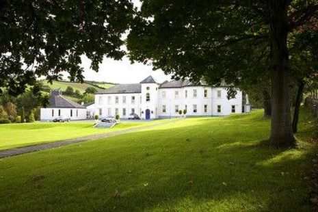
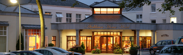
| Glenarde | Town house of the Persse family, built in the mid 19th century, bought by the Bolands of Bolands biscuits in the 1920s and since the early 1960s has functioned as the Ardilaun House Hotel. |
|
| Glenasrone | Built in the early 1850s for Richard Ellis MP to the design of John Joseph Lyons. In 1906 this mansion house was valued at £25.17 shillings and was occupied by Richard Ellis. Cussen writes that this house was burnt during the "Troubles". Grid Reference is approximate. | |
| Glenastar | Glenster was occupied by Samuel Upton in 1814 and by J.U. Upton in 1837. Described at the time of the first Ordnance Survey as a small thatched house of one storey, the residence of John Upton. By the time of Griffith's Valuation the townland of Glenastar was held by the representatives of John Upton. The highest value on any house in the townland was £1.15 shillings and it was held by them in fee. A house is still extant at Glenastar. |