Browse Houses
Search Results: Returned 5927 records. Displaying results 1701 – 1800
| House name | Description | |
|---|---|---|
| Cloonfinlough Lodge | Occupied by Robert Devenish at the time of Griffith's Valuation, who held the property from John Caulfeild. Buildings are still extant at the site. | |
| Cloonfree | The residence of William Mahon. Apparently the residence of George Knox in the 1840s. http://www.ballykilcline.com/story_f.html | |
| Cloongee | Originally a Moore home which was sold by Harloe Phibbs Baker to the McDermotts who lived there until the 20th century. At the time of Griffith's Valuation it was held in fee by Owen McDermott and valued at £7. The National Inventory of Architectural Heritage notes Cloongee as a rare survivor of a late-seventeenth century house in county Mayo. It is still extant and occupied. |

|
| Cloongownagh | Thomas and Andrew Kirkwood had houses in this locality in 1814. Thomas resided at Hermitage and Andrew at Lakeview. At the time of Griffith's Valuation Andrew Kirkwood was occupying a property at Cloongownagh, barony of Boyle, valued at £13. Keenehan and others state that Cloongownagh House was built in 1690. It was occupied by the Kirkwood family until 1939 when Col. Moore Kirkwood sold the house and 109 acres. The house is still extant and occupied and is now part of a farm. | |
| Cloonkea | John Eyre was leasing a house valued at £10 from the estate of Dr. Duggan in 1855. The house was located at Cloonkea, barony of Longford. It was advertised for sale in 2007. |
|
| Cloonkeen House | Patrick Sweeney was leasing a house valued at £12 at Cloonkeen, barony of Castlereagh, from the Sandford estate at the time of Griffith's Valuation. It is labelled Cloonkeen House on the 25-inch edition of the Ordnance Survey map. A house is still extant at the site. | |
| Cloonkeen House (Kilmacabea) | Leased by Sarah Dorman to Florence McCarthy in 1851 when the house was valued at £9. A house still exists at the site. | |
| Cloonkeen Lodge (Kilkerrin) | Cloonkeen Lodge is shown on the 25-inch edition Ordnance Survey map of the 1890s. It occupies the site of an earlier settlement, Ballyphillipeen, shown on the 1st edition Ordnance Survey map. At the time of Griffith's Valuation this townland was held by William P. Cullen who held a house, valued at almost £5 in fee there. The building is still extant though not apparently in use. |
|
| Cloonkerry House | Cloonkerry was an 18th century house on the Vandeleur estate. The house was occupied by Richard Brew in 1814 and by members of the Lloyd family in 1837 and in the 1850s. Weir writes that the house is now demolished. According to local information this house was once a police barracks. | |
| Cloonkilla | James H. Mandeville held buildings valued at £21 from James N. Cronin among the woods at Cloonkilla at the time of Griffith's Valuation. | |
| Cloonlara | Christopher Gallway was leasing this property to William Hickson at the time of Griffith's Valuation, when it was valued at £7 5s. A farm is still extant at the site. | |
| Cloonlyon | In 1786 Wilson refers to Clonlyon, the seat of Mr. Kelly. The 1st edition Ordnance Survey map shows ruins in this townland. | |
| Cloonmore | At the time of Griffith's Valuation occupied by William McMahon, held from Timothy McMahon and valued at £10. This was a one storey thatched house, a modern house is now located near the site. |
|
| Cloonmore | At the time of Griffith's Valuation the house was valued at £3 and was held in fee by Charles Grant.It is labelled Cloonmore on both the 1st and 25-inch edition Ordnance Survey maps but is no longer extant. | |
| Cloonmore | In 1786 Wilson refers to Cloonmore as "the fine seat of Mr. Phillips". The house was inhabited by Myles McDonnell in the first two decades of the 19th century. It was described as 'a mansion house in good order and suitable for the accommodation of a gentleman's family' when Phillips sold the estate in 1853. It was unoccupied at the time of Griffith's Valuation. Only the foundations of a flight of steps now remains of the house. |
|
| Cloonmurray | Leased by Marcella Dillon to the Reverend Michael Lennon at the time of Griffith's Valuation and valued at £9. Some ruins remain at the site. | |
| Cloonnagashel | A house inhabited by the Gildea family from the mid 18th century and situated on the estate of the Earls of Lucan. Wilson refers to it as the seat of James Gildea in 1786. It was the home of James Simpson between 1855 and 1880 , valued at £25 at the time of Griffith's Valuation. Later occupied by the Egan family. It now functions as the club house for Ballinrobe Golf Club. |
|
| Cloonnakilla | A house occupied by John Ryan medical doctor and held from John Bindon Scott in the 1850s. John Ryan was still resident in the 1870s. | |
| Cloonshanbally | Margaret and Henry Gorman were leasing a property valued at £12 at Cloonshanbally, barony of Tirerrill, from the Gore Booth estate at the time of Griffith's Valuation. | |
| Cloonshanville | William Davis was the occupier of a property valued at £8, together with over 120 acres at Leggatinty, barony of Frenchpark, at the time of Griffith's Valuation. In the same townland he was leasing a property, including a corn mill, valued at £18, to James McCann. In 1814 Paul Davis was resident at Clonchanville, Frenchpark and Lewis records this as the seat of J. Davis, in 1837. The 1749 Census of Elphin records W. Davis resident at Clegarna in the parish of Tibohine. Only some foundation stones of Cloonshanville Mill remain. There is a house, probably not original, on the site of Cloonshanville House. |
|
| Cloonta | Nicholas McGaver held this property in fee at the time of Griffiths Valuation in the 1850s, when it was valued at almost £12. The Ordnance Survey Name Books describe the property as a 'good farmhouse with trees and plantations' in the 1830s. The 1906 Untenanted Demesnes survey record a valuation of almost £12 when it was owned by Patrick McGaver. It is now ruinous. | |
| Cloonteem | Described in 1837 by Lewis as "a handsome and newly erected lodge of the Marquess of Westmeath". The house was valued at £14 in the 1850s and was held by Lord Greville in fee. The buildings have disappeared by the time the 25-inch Ordnance Survey map was published in the 1890s. | |
| Cloonteen | A house in the townland of Cloonteen is named Ballyallia on the first Ordnance Survey map. It was valued at £30 and was held by John Enright in fee at the time of Griffith's Valuation, now a ruin. Weir called this residence Templemaley House, the name by which it is labelled on the 25-inch map of the 1890s. | |
| Cloonteen | At the time of Griffith's Valuation occupied by George Jennings when the house was valued at £7. Some ruins remain at the site. | |
| Cloonties House | Mary Gillman was leasing this property from Jacob Biggs in 1851 when it was valued at £10 15s. There is still an extant house at the site. | |
| Cloontoo | Adrian Taylor was leasing a property valued at £15 15s from John Croker at the time of Griffith's Valuation. Lewis notes it as the seat of R.E. Orpen in 1837. In 1814 Leet records the house as the seat of Edward Orpen. In 1851 the property was included in the sale of the Croker estate in the Encumbered Estates Court when Adrian Taylor was the occupier. It remained a residence of the Taylor family until the 1950s. Cloontoo is still extant and occupied. | |
| Cloontreston | The notice advertising the sale of Michael Francis Treston's property at Cloontooa, barony of Clanmorris states that "the dwelling house with the offices, garden and demesne, known as Cloontreston, is in fair order and condition, suitable as a residence for a gentleman". At the time of Griffith's Valuation the townland was owned by John Treston who also held a herd's house there. The house is labelled Cloontreston on twentieth century maps. Buildings are still extant at the site. | |
| Cloonts | Henry Moriarty Cronin was leasing this property from the Kenmare estate at the time of Griffith's Valuation, when it was valued at £5 10s. Bary states that it was later occupied by Daniel O'Halloran but is no longer extant. | |
| Cloonturk | At the time of Griffiths Valuation in the early 1850s, James Shaw was leasing this property for Richard Greville’s estate, when it was valued at £13 and included a mill. It is no longer extant | |
| Cloontykilla Castle | This building was constructed after the publication of the first Ordnance Survey Map. It appears to have functioned as a shooting/fishing lodge for the King estate. It is now a ruin. |
|
| Cloonusker | On the first Ordnance Survey map Cloonusker house is marked "in ruins". However by the time of Griffith's Valuation Henry Sparling was occupying a steward's house, which he held from Lord Norbury. The buildings were valued at £8. | |
| Cloonyhea | A house valued at £11+ was occupied by Thomas Mansfield at Cloonyhea in the mid 19th century. It was held from John Bradshaw. A small house is marked on the first edition Ordnance Survey map at this location. It had increased considerably in size on later maps, still extant. | |
| Cloonyquin | Home of the French family, including the song writer Percy French, sold by the family in the 1950s. In 1786 Wilson refers to it as a seat of Arthur French in 1786. Valued at £24 in the mid 19th century. The house was demolished in the 1960s. See www.percyfrench.ie. |
|
| Cloonyscrehane | This house, located on the Devon estate, was valued at £12 at the time of Griffith's Valuation and was the residence of Patrick Candon. A house and farm are still extant at the site. | |
| Clooskirt | At the time of Griffith's Valuation, Mrs. Ormsby Gore was leasing this property to William Wilson. It was then valued at £12. At the same time Ruttledge Burrowes was leasing a property valued at £4 with over 140 acres of land from the Ormsby Gore estate. Johnston states that a "model farm" was established here in the later nineteenth century. This townland is mentioned as Clooshire, in 1906, when George Ormsby Gore was the owner of the property but there is no valuation given for buildings at that time. It was subsequently lived in by the St. Lawrence family. |
|
| Cloran | A house valued at £10. 11 shillings at the time of Griffith's Valuation, occupied by Miss Mary Kelly and held from the Earl of Clare with 224 acres. A building is still located at this site. | |
| Clorane | A house occupied by Henry Hunt in 1814. Lewis describes Clorane as a "fine old house belonging to the Hunt family". By the time of Griffith's Valuation Edward Browning was leasing the house and 280 acres from Sir David Roche. In the 1870s in the possession of Patrick Hartigan. Old farm buildings are still located at the site but the house is a modern structure. |

|
| Clorhane | Home of Thomas Dalton in the mid 18th century and of the Fosbery family in the 19th century. Held by George Fosbery junior at the time of Griffith's Valuation when the buildings were valued at £11. Home of Francis Wise Browning in the early part of the 20th century following his marriage to Jane Philippa Fosberry daughter and co heiress of Thomas Fosberry of Kilgobbin and Clorane. Cussen writes that this house is now demolished. | |
| Clover Hill | Another Waddell home, also named on the 1st edition 6 inch Ordnance Survey map (1836). It was occupied by William Waddell in the mid-19th century and held from Charles Waddell. The value of the buildings was £4.10.0. This house was the home of Alexander Waddell and family in the early 20th century. |
|
| Cloverfield | In 1786 Wilson mentions a house called Cloverfield three miles beyond Caherconlish as the seat of Mr. Lloyd. A house named Cloverville is marked on the first edition Ordnance Survey map. On later maps a much larger building is marked. At the time of Griffith's Valuation valued at £9.5 shillings was vacant in this townland. Richard Laffan, a dairy farmer, is recorded as the immediate lessor. The National Inventory of Architectural Heritage dates the original building from circa 1830 with later 19th century additions. The house continues to be used as a residence. |

|
| Cloverfield | Joseph E. Nolan was resident at the time of Griffith's Valuation when the house was valued at £4. It appears to have become ruinous by the time of the 25-inch Ordnance Survey map of the 1890s. | |
| Cloverhill | Cloverhill was part of the Earl of Erne's estate in county Sligo. At the time of Griffith's Valuation, it was leased to William C. Chambers when it was valued at £28. In 1786 Wilson had noted it as a seat of "Mr. Chalmers" so it had been occupied by that family since the eighteenth century. Cloverhill House was demolished in 1988. Some remains of estate walls visible. | |
| Cloverhill | At the time of Griffith's Valuation, Thomas Cox was leasing a house from the Lloyd estate at Bunreagh, barony of Boyle, valued at £10 . This property is labelled Cloverhill on the 25-inch map of the 1890s. A house and substantial farn are still extant at the site. | |
| Cloverhill | Latouche esquire lived at Cloverhill in 1778 and Wilson refers to it as the seat of John La Touche in 1786. The residence of Thomas Hurst in 1814 and of John Hurst in 1837. Occupied by Edward Jones, who held from Thomas Booth, at the time of Griffith's Valuation. The main road has been directed through the site and only a few ruins remain. | |
| Cloverhill | This three storey mansion was built in the early years of the 19th century to the design of Francis Johnston. Attached to the rear was an earlier two storey house dating from 1758. In 1814 Cloverhill was the home of James Saunderson. The Ordnance Survey Field Name Book describes Cloverhill as ‘a neat dwelling house with portico of the Ionic order, is in the centre of the townland, in good order, well planted about good orchards, gardens etc’. Griffith’s Valuation records Mary. A. Saunderson as the occupier holding the property in fee. It had a rateable valuation of £40. Cloverhill passed to the Winter family through the marriage in 1826 of Lucy, daughter of James Sanderson, to Samuel Winter of Agher, county Meath. Their third son, Samuel Winter, born 1834, inherited Cloverhill. He died in 1905 and Cloverhill passed to his nephew, John James Purdon, who died unmarried in 1933. The house was sold in the late 1950s by J.J. Purdon’s nephew, Major John Nugent Purdon. It is now an ivy clad ruin. |

|
| Cloyne House | Originally the Bishop's Palace, by 1837 it was known as Cloyne House and occupied by H. Allen. Valued at £50, occupied by John Wilkinson and held from the Ecclesiastical Commissioners at the time of Griffith's Valuation. |
|
| Cluen House | An 18th century house originally known as Mount Kennedy. This house valued at £15 was being used as an auxiliary workhouse in the mid 19th century. It was held by John Kennedy from Thomas Slattery. In 1906 Lord Barrymore is recorded as the occupier and the building were valued at £28+. |

|
| Clyda | Hajba records the building of this house by Charles Haines in 1805. Occupied by Joseph Barry in 1814 and by the Reverend M. Becher in 1837. In the 1850s it was the residence of the Reverend Henry Swanzy who held it from Thomas Haynes. The buildings were valued at £24. Later the home of Lieutenant Colonel Robert D. Perry. In 1944 the Irish Tourist Association Survey noted it as the residence of Mr. Mandeville. In the late 20th century it was owed by the O'Meara family. |
|
| Clydagh | Built in the early 1820s close to the shore of Lough Corrib, a residence of the Lynch Stauntons until the early 20th century and still occupied. IN 1894 Slater noted it as a seat of B. O'Neill Power. |
|
| Clydaville | Mrs Callaghan lived in this houses in 1814 and Mrs Sankey in 1837. Held by Hugh Delacour from Charles Haynes in the early 1850s when the house was valued at £15. The residence of the O'Connor family in the 20th century. Hajba records that the house was demolished in April 2002. | |
| Clynan House | Bevan Slator was occupying Clynan at the time of Griffiths Valuation in the 1850s, when it was valued at £24. It was leased from William C. Rochfort. In 1840 the original valuation had recorded it as the seat of Bernard Slator with the same valuation. The National Built Heritage Service associates the property with the Coates and Slator families. It is now ruinous. | |
| Coalbrook | A Langley home in the 18th and 19th centuries. The Ordnance Survey Name Books describe the demesne as "nearly one half wood and oranmental ground" in 1838. It was valued at £35.10 shillings in the mid 19th century when held by Henry Langley in fee. George Langley was the occupier in 1906 when the buildings were valued at £41+. This house is still extant and lived in. |
|
| Coarsefield | The Grays were in possession of Coarsefield by the late 1830s. The present house was probably built by the Tighe family who bought Coarsefield from the Grays and sold it to the Stephens family in the early 20th century. |
|
| Codrum | In 1837 Edward Ashe was occuping a house in the townland of Condrum and this house remained the residence of Edward Ashe until at least the 1870s. In the early 1850s it was valued at £18.15 shillings. It is labelled Codrum West on the 1st edition Ordnance Survey map and as Codrum on the later 25-inch edition of the 1890s. It is still extant. |
|
| Codrum House | In the 1770s and 1780s Codrum was occupied by Hutchinson esq. It was the residence of John Warren in 1814. There were two houses in this townland at the time of Griffith's Valuation, one occupied by Richard Ashe and the other by Massy H. Warren. The Warren house was known as Codrum House. It was valued at £19. Frederick H. Warren was resident in the 1870s. In 1944 the Irish Tourist Association Survey referred to Codrum as the home of Mrs.S.W. Baldwin and also to the murder of Colonel Hutchinson there. The original house at this site is now a ruin. | |
| Colehill | Reverend Hugh Norman was leasing this property from the Earl of Wicklow's estate at the time of Griffith's Valuation in the 1850s when it was valued at £12. It is labelled Colehill on the 1st edition map of the 1830s but as Allsaints Rectory on subsequent Ordnance Survey maps. It is still extant. | |
| Colehill (Longford) | The Ordnance Survey Name Books noted that Colonel White was the proprietor of the townland of Colehill. The house of the same name was leased by a Mrs. Power to Captain Robert N. Bolton at the time of Griffiths Valuation in the 1850s, when it was valued at almost £18. The Valuation Office House books of the 1840s record Thomas Lennon as the occupier at that time. The National Built Heritage Service dates the original part of this house to the 1760s with later additions in the mid 19th century. It indicates that the house was associated with the Nugent family. It is still extant and occupied. |
|
| Coleraine | The seat of the Price family occupied by William Price in the mid 19th century and held by him in fee. The buildings were valued at £31.15 shillings. Thomas Price was resident in 1906. This house is still extant and occupied. | |
| Colgagh House | Edward Homan was leasing a property valued at £18 from the Ffolliott estate at Cogagh, parish of Calry at the time of Griffith's Valuation. McTernan writes that the Homans continued in residence until the 1880s. Colgagh House is still extant and occupied. |

|
| Colligan Lodge | Reverend Craddock was leasing this property from the McGuire estate at the time of Griffith's Valuation, when it was valued at £15 10s. The house is labelled Colligan Lodge in the 25-inch Ordnance Survey map of the 1890s. The famous greyhound "Master McGrath" was born at Colligan Lodge in 1866, when it was the home of James Galwey. In 1906 it is recorded as part of the Earl of Dartry's estate and valued at almost £25. Waterford County Museum researchers note that the building was dismantled in the 1940s. | |
| Colmanstown | Originally a French property which became a Quaker settlement. Griffith's Valuation describes the buildings as a herd's and steward's house occupied by Edward Barrington and partners and then valued at £30. Buildings on both sides of the road mark the site of Colmanstown. Only the walls remain of some of these buildings, others are still in use. |
|
| Comeragh House | At the time of Griffith's Valuation, Col. Wray Palliser was leasing this property from Phineas Hunt, when it was valued at £28. It is recorded as the address of John Palliser in the 1870s. Though badly damaged by fire in 1923, Comeragh house was restored and is still extant. The ITA survey of 1942 noted it was in the ownership of Captain Fairholme at that time. It was offered for sale in 2010. |
|
| Comeragh Lodge | Thomas Hunt was leasing this property from Col. Palliser's estate in 1851, when it was valued at £14. It is still extant and occupied. |
|
| Commeen | Thomas Hayes was leasing this property to Richard Hayes at the time of Griffith's Valuation, when it was valued at £8, on a holding of 230 acres. On the 25-inch Ordnance Survey map of the 1890s it is labelled Commeen Kennels. Farm buildings still exist at the site. | |
| Concamore House | James Nelson Crofts was leasing this property from Lady Carbery's estate at the time of Griffith's Valuation, when it was valued at almost £10. He was the fifth son of William Crofts of Velvetstown and was married to Dora, daughter of Jasper Lucas, of Richfordstown, Clonakilty. There is still an extant house at the site. | |
| Condonstown | Timothy Mahony occupied a house valued at £6 which he held with 165 acres at Condonstown North from J.H.S. Barry in the mid 19th century. By 1906 the buildings were valued at £15+ and Arthur H.S. Barry is given as the occupier. Grid reference is approximate. | |
| Congor | Occupied by F. Falkiner in 1837 and described by the Ordnance Survey Name Books as "the commodious residence of Nicholas Biddulph" in 1840. It was still occupied by him at the time of Griffith's Valuation when the house was valued at £20. Nicholas Biddulph was still resident in the mid 1870s when he is recorded as owning 74 acres in county Tipperary. A building is still located at this site. | |
| Conna | ||
| Connonagh House | John Morris was leasing this property to Barbara Jago in 1852 when it was valued at almost £8. There is still an extant house at the site. |
|
| Convamore | This property was sold by the Bailey family to the Hares in the late 18th century. William Hare, 1st Earl of Listowel, built a new house beside the River Blackwater in the early 19th century. He was residing at Convamore in 1814. At the time of Griffith's Valuation the buildings were valued at £100 and the property was held by the Earl from the representatives of D. Callaghan. Callaghan's interest was advertised for sale in July 1853. It was still the Earl's seat in 1894. The house was burnt during the War of Independence in 1921 and is now a ruin. |

|
| Convamore Upper | J. Delany was the proprietor of Upper Convamore in 1837. George Crofts occupied the house in the early 1850s. He held it from the Reverend G. Atkins Collins and it was valued at £16. The property was later bought by the Reverend Maurice Collis who sold it to the Earl of Listowel. Unoccupied for much of the 20th century it was demolished in 2000. | |
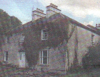
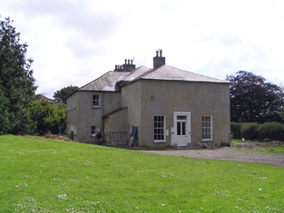
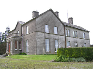
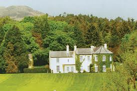
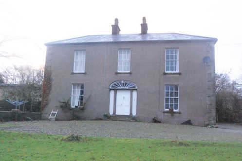
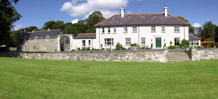
| Convoy House [Greenfield] | Robert Montgomery held this property in fee at the time of Griffiths Valuation when it was valued at £35. In 1837 Lewis had also referred to it as the seat of R. Montgomery. In 1896 it was owned Canon Boyton and valued at £33. The National Inventory of Architectural Heritage suggests it was built in the early years of the 19th century and provides a detailed description of its occupancy. It is still extant and occupied. |
![Photo of Convoy House [Greenfield]](https://landedestates.ie/storage/img/orig/3296.jpg)
|
| Cooga | A house on the O'Callaghan estate, inhabited by the Lingard family from at least 1837. Sold by the Lingards to the Hogans in 1922. | |
| Cooga Lodge | The house at Cooga was valued at £26 in 1906 and was the property of John Howley.At the time of Griffith's Valuation Patrick Howley had a steward's house here, valued at £4, together with 300 acres. [Grid Reference is approximate]. Local folklore suggests it afterwards became the residence of the local priest. |
|
| Cooksborough House | Cooksborough House is named on the first edition OS map but greatly altered by the time of the 25 inch map. The Cooke family were settled here from the 17th century. O’Brien writes that it was ‘a large rambling mainly Georgian house’. It was the home of many generations of the Cooke family. It is marked on the Taylor and Skinner map of the 1770s, Robert Cooke was resident in 1814 and Lewis refers to the ‘fine mansion of the Cooke family’ in 1837. The eccentric family member Adolphus Cooke lived here at the time of Griffith’s Valuation (publ. 1854), holding the house in fee. It was valued at £35. After his death in 1876 and the litigation that followed the house passed into the possession of Edward Michael Pakenham, a younger son of the 4th Earl of Longford, to whom he had bequeathed it. A caretaker Thomas Keenan and his family were resident in 1901 and in 1906 the Rt Hon E M Pakenham is recorded as the occupant. The house was demolished many years ago. | |
| Coolagarry | Charles Ellison was leasing a property at Coolagarry valued at £8 10s from Viscount Dillon's estate at the time of Griffith's Valuation. The Ordnance Survey Field Name books record that there were no houses that could be called farmhouses in this townland in 1837 so it is assumed that Coolagarry must have been constructed 1837-1855. There is still a house extant at this site. |
|
| Coolagh | Coolagh is described in the Ordnance Survey Name Books as "a good dwelling house in a small demesne with plantation and ornamental ground" in 1841. It was occupied by John Brindley in the mid 19th century. Valued at £12+ it was held from the Very Reverend Dean Head. It is still extant. | |
| Coolaghy (Raphoe) | William Hamilton was leasing this property from Reverend Lord Edward Chichester's estate at the time of Griffiths Valuation in the 1850s, when it was valued at £20. It appears to have been associated with the Hamilton family for much of the nineteenth and early twentieth centuries. It is still extant and occupied. |
|
| Coolaghy Lower | Reverend George Hanson was leasing this property from the Abercorn estate at the time of Griffiths Valuation in the 1850s, when it was valued at £12. A substantial farm exists at the site. | |
| Coolalta | This house was the residence of the Reverend Pierce Green PP in 1837. It is named Coolalta Cottage on the first Ordnance Survey map and Coolalta on the later 25-inch edition of the 1890s. Occupied by Frederick Arden, valued at £13+ and held from Thomas Crooke at the time of Griffith's Valuation. A house is still extant at the site. | |
| Coolamber | Philip O’Reilly was leasing this property from the Blackall estate at the time of Griffiths Valuation, when it was valued at almost £23. The property was associated with the Blackall family by whom, according to O'Brien, it was built c.1830. Later in the nineteenth century it came into the possession of the O’Reilly family. Towards the end of World War II it was, for a time, the home of Prince Ernest, Duke of Saxony. Since the early 21st century, it has been undergoing restoration and now serves as venue for occasional gardening courses. |
|
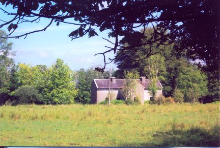
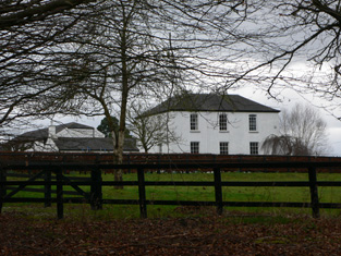
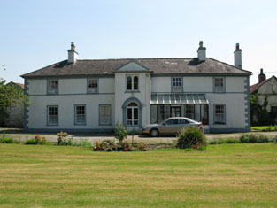
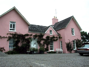
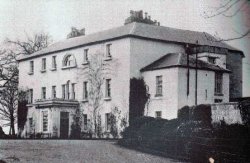
| Coolamber Manor [Cloonshannagh] | At the time of Griffiths Valuation in the early 1850s, Coolamber was held in fee by Major Blackall, when it was valued at £75. It is labelled "Cloonshannagh House" on the 1st edition OS Map but as "Coolamber Manor" on the later editions. The National Built Heritage Service suggests it was built c.1830 and significantly extended c.1880. It is still extant, having previously functioned as a rehabilitation facility. Extensive estate architecture also survives. |
![Photo of Coolamber Manor [Cloonshannagh]](https://landedestates.ie/storage/img/orig/3355.png)
|
| Coolaran | Sometimes spelt Coolarne. At the time of Griffith's Valuation, the Meldon estate owned a herd's house at Coolarne. Later the property became a convent of the Sisters of the Sacred Heart. It is now an addiction treatment centre. |
|
| Coolard House | At the time of Griffith's Valuation, Samuel Raymond, MD, was leasing this property to Patrick Dalton, when it was valued at £10 5s. A house still exists at the site. | |
| Coolatore | This house was not built at the time of the first edition OS survey. It was constructed about 1866 and was the home of members of the Upton family. In 1906 it was valued at £56, occupied by Henry N S Upton who held it with over 400 acres of untenanted land. According to the discover Ireland website it now provides self-catering accommodation. |

|
| Coolavin | McParlan described the Coolavin of 1802 as a "delightful retreat". The house at Clogher was offered for sale as part of the McDermott estate in 1852. By the time of Griffith's Valuation it was occupied by Joseph Holmes and was valued at £16. In 1906 Coolavin was valued at £35. The house now known as Coolavin was built in the 1890s replacing an earlier house near the same location. This latter house is still extant and occupied. The original house at Clogher is now derelict. |
|
| Coolbane | Mahony Harte was leasing a property valued at almost £6 to Denis McGillycuddy at the time of Griffith's Valuation. | |
| Coolbeg | ||
| Coolbeg House | In 1856 Thomas Stratford Eyre was leasing a property valued at £5 together with 146 acres, located in the townland of Coolbeg, parish of Clontuskert, barony of Longford to William Seymour. It is labelled Coolbeg House on the 25-inch Ordnance Survey map of the 1890s. A house still exists at the site. | |
| Coolboy | A herd's house and offices situated on the St Leger estate was occupied by Henry Ievers at the time of Griffith's Valuation when the buildings were valued at £14+. Coolboy was occupied by the representatives of Robert Cleary in 1906. A substantial farm is still extant at the site. | |
| Coolbunnia | In 1848, Margaret Cheasty was leasing this property from thel Power estate when it was valued at £10. The house is adjacent to the the site of Faithlegg Castle, the original stronghold of the Aylward family in the area. | |
| Coolcarta Farm | At the time of Griffith's Valuation Allan Pollok held a property valued at £20 in the townland of Annaghcorrib, parish of Clonfert, barony of Longford. It is labelled as Coolcarta Farm on the 25-inch Ordnance Survey map of the 1890s. Padraig Lane states that this property was damaged by fire during land agitation in the 1850s. A substantial farm still exists at the site. | |
| Coolclogher or South Hill | Reverend Richard Herbert was leasing a property valued at £21 to John Leahy at the time of Griffith’s Valuation. He was also leasing a mill, valued at £90 to Richard and John Leahy in the same townland. Lewis records South Hill as the seat of J. Leahy in 1837. Bary states that the house was probably built in the earlier 18th century though it may have been renovated in 1810, probably by the Leahys, in whose family it remained until the end of the 19th century. The Irish Tourist Association survey in the early 1940s reported that it was the private residence of Mr.R. Hilliard. It is now a luxury guest house. See www.coolclogherhouse.com. |

|
| Coolcon Castle | Originally a Burke castle and later a residence of the Blakes in county Mayo, very little of this castle now remains. | |
| Coolcour/Coolcower | Home of the Browne family in the 18th and 19th centuries, occupied by John Browne in 1814, by W.G. Browne in 1837 and still his residence in the 1870s. In the early 1850s the house was valued at £46 and was held in fee. St George G. Browne was resident in 1906. Coolcour was burnt in July 1921, just before the end of the War of Independence, when it was the residence of Richard C. Williams, a hotel owner in Macroom. It was rebuilt and now functions as a guest house, see http://www.coolcowerhouse.ie/ |
|
| Coolcronaun | Coolcronan House was built by Edmond Pery at the time of his marriage to Sarah Jane Knox Gore in the mid-nineteenth century. The family owned the property until the 1950s. The Irish Tourist Association File states that it was erected in 1860 by the Knox Gores. It was extensively renovated in the late 1990s and is still extant and available as holiday accommodation. See http://www.coolcronan.com. |
|
| Cooldaniel | This house was the home of Barter esq in the 1770s and 1780s, of Thomas Barter in 1814, of J. Barter in 1837 and of Michael Buckley at the time of Griffith's Valuation who held it from William Gallagy. It was valued at £10. In the 1940s the Irish Tourist Association Survey noted that it had been converted to farm buildings.. | |
| Coolderry | Coolderry House, located close to the bank of the River Lagan, was the home of the Forster family, baronets. It was a two storey house built in the late 18th century on the Brownlow estate. The buildings were valued at £45. A lithograph of the house is part of the Encumbered Estates sale rental of 4 April 1854. The demesne was described as 'beautifully planted' and the house as 'spacious, with suitable out-offices, stabling etc, built in a permanent manner, and at present in the most perfect order'. At the time of Griffith’s Valuation (publ. 1860), Sir George Forster was resident holding the property from the Reverend Anthony Garstin. Home of Claude Brownlow, estate agent, and family at the beginning of the 20th century. Bence Jones writes that the house was sold by Claude Brownlow’s son, Colonel Guy James Brownlow, in 1920. The house was later demolished. |

|
| Coolderry | Occupied by Thomas Kelly in 1814 and by Bryan Fenerty in the 1850s. | |
| Coole | Coole House was built in the late 18th century for Robert Gregory. It was demolished in 1941 but the gardens and some of the parkland are still extant and maintained by the Forestry and Wildlife Service. Part of the farm buildings now houses an interpretive centre and tea rooms. See www.coolepark.ie |
|