Browse Houses
Search Results: Returned 5927 records. Displaying results 1601 – 1700
| House name | Description | |
|---|---|---|
| Clogher | According to Bence Jones this house was built circa 1798 though Wilson refers to a house at Clogher as the seat of Patrick Lynch in 1786. In 1844 Samuel Nicholson described Clogher House as "amongst the largest and the best in the Country, and appears to be kept in excellent order". Patrick C. Lynch was leasing it from Sir Robert H. Blosse at the time of Griffith's Valuation, when it was valued at £40. It was in the ownership of the Fitzgerald Kenney family at the beginning of the 20th century and is now a ruin. |
|
| Clogher Beg | Mary Gormley writes that this house was built by the Knoxes who acquired some of the Plunkett of Castle Plunkett estate. Occupied by Thomas Stafford at the time of Griffith's Valuation, held from James Murphy. | |
| Clogher West | A house occupied by John Fitzgerald and held from George Whitelock at the time of Griffith's Valuation. The buildings were valued at £12. The original house does not appear to be extant. | |
| Clogherboy Cottage | David Rutledge was leasing a house valued at over £8 to James Kealy at Clogerboy, barony of Clare, at the time of Griffith's Valuation. The house was later known as Cahergal. There is still a building extant at this site. |
|
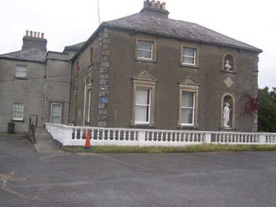
| Clogherevagh | The house at Clogherevagh now forms part of St. Angela's College, a constituent college of NUI, Galway. The National Inventory of Architectural Heritage estimates that the house was built c.1890. At the time of Griffith's Valuation much of the townland was the property of John Wynne's estate. In 1894 Slater notes it as the residence of John Cochrane. |
|
| Cloghers House | In 1786 Wilson refers to Cloghers as the seat of Richard Yielding. John Mulchinock was leasing two adjoining properties from the Colthurst estate at the time of Griffith's Valuation, one valued at £50 and the second at £15. The Irish Tourist Association Survey notes that Cloghers was "once the home of the Mulchinock family who were big landowners" and relates the story of the song "the Rose of Tralee". Bary writes that this property was associated with the Carrigue family in the eighteenth century and also that John Mulchinock was an uncle of William Mulchinock, author of the song. She indicates that it was later owned by the Fitzmaurice family. It is still extant. |
|
| Cloghfadda House | Occupied by Joseph Wiseman in the early 1850s, held from Robert A. Rogers and valued at £12. The Crofts sale rental of 1881 record Cloughfadda House as a comfortable residence in "owner's hands". A house is still extant at the site. | |
| Cloghjordan House | This house was the home of the Reverend Edwin Palmer in 1814. By the time of Griffith's Valuation John Hodgins occupied the house and ran the nearby nursery gardens. The buildings were valued at £13+ and held from Lord Dunalley. This building which includes the remains of the old castle still functions as a country residence. |
|
| Cloghkeating | The home of Augustus Robinson from the 1830s. The Ordnance Survey Name Books refer to Cloghkeating as "a large new house" in 1841. At the time of Griffith's Valuation Augustus Robinson held the property in fee and the buildings were valued at £19. Augustus Robinson of Cloghkeating owned 231 acres in the 1870s. This house is still in use as a residence. |

|
| Cloghlough | At the time of Griffith's Valuation, William O'Brien was leasing a property valued at £8 at Cloghlough, barony of Carrigallen, from the estate of John King, which was in Chancery. Substantial farm buildings exist at this site. | |
| Cloghprior House | The home of the Woodward family until sold to Edwin Cuthbert in 1844. The Ordnance Survey Name Books describes it as "at present in a state of very bad repair, but bears marks of ancient splendour". Held by Edwin Cuthbert in fee at the time of Griffith's Valuation and valued at £5.5 shillings. Daniel Grace writes that it was renovated by John Flower circa 1860s and leased to John Talbot. The Talbot family continued to reside at Cloghprior until the early 20th century. | |
| Cloghroe House | In 1786 Wilson refers to Cloghroe as the seat of Mr. Capel. In the late 18th century this house passed by marriage from the Capel family to the Fitzgerald family. J. C. Fitzgerald was resident at Cloghroe in 1814. The house, valued at £28, was occupied by Thomas Keogh in the early 1850s and held from Thomas Fitzgerald. In 1944 the Irish Tourist Association Survey referred to it as the residence of Major O'Mahony of Blarney Mills. A house is still extant at Cloghroe. | |
| Clonacody | The residence of John Hunt in 1814 but the Kelletts were resident by 1837. The Ordnance Survey Name Books refer to Clonacody as the seat of John D. Kellett. James Sadlier was the occupier in 1850 holding the house valued at £28+ from John Kellett. The sale rental of 1856 records James Sadlier as tenant under the Court of Chancery in a case Massey v Kellett. The Kellett family continued to live at Clonacody until the mid 20th century and the house is still extant. |
|
| Clonalis House | The present Clonalis House was built in the late 1870s replacing an earlier Georgian house, the ruins of which can be seen at Clonalis. Charles Owen O'Conor, the O'Conor Don, lived here at the time of Griffith's Valuation when the existing house was valued at £35. In 1814 Clonalis is recorded as the residence of John Balfe. The Census of Elphin records Margaret O'Conor as residing in Clonalis in 1749. |
|
| Clonamully | This house, sometimes spelt Clenamully, was the home of the Fiddes family in the 19th century. Members of the Fiddes family were land agents. Located on the Lewis, formerly Scott estate, it was named on the 1st edition 6 inch Ordnance Survey map (1836) and had a walled garden. The Reverend James Fiddes was rector of the parish of Drumsnat. Edward Fiddes who inhabited the house in the 1830s and at the time of Griffith’s Valuation was the Reverend James’ son and agent to the Rose estate. Edward died in 1868, aged 78, and was buried in Drumsnat graveyard. In 1901, Joseph Fiddes, land agent, was the occupier and in 1911 four of his children were living in the house. The original house has had additions and alterations. |
|
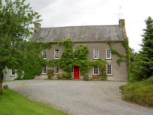
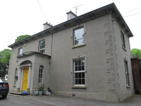
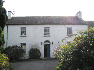
| Clonard House | Bellview, now known as Clonard House, is a two-bay two-storey over basement house, built about 1800, located in the town of Mullingar, home of the Walsh family. Robert Walsh was resident in 1814 and Thomas Walsh in 1837. He was still resident at the time of Griffith’s Valuation (publ. 1854), when the house was valued at £40 and held in fee. In 1876 Thomas Walsh of Bellvue owned 528 acres. In the mid-20th century this house was the residence of the Catholic Bishop of Meath. Since then it has been a tourism headquarters and an entertainment venue (O’Brien) and was for sale in 2022. |
|
| Clonbern Park | A house built after the publication of the 1st edition Ordnance Map. The property in this townland was held by Charles O'Rorke at the time of Griffith's Valuation when it was valued at almost £8. Clonbern Park no longer exists but the stable block and walled garden are still evident on the site. |
|
| Clonbonane | Edmund Scully of the Silverfort branch of the Scully family lived here in the first half of the 19th century. By the time of Griffith's Valuation Jeremiah Scully held the house valued at £12 from the Earl of Norbury. This house no longer exists. | |
| Clonboy | Located on the Barrett Lennard estate, on the outskirts of Clones, this house was built in the latter half of the 19th century. It is not mentioned in Griffith’s Valuation and was the home of the Pringle family. Many members of this family were solicitors. In the mid-20th century it became the home of the Bishop of Clogher. |
|
| Clonboy | An 18th century house of the Brown family held from the Westropps in the mid 19th century. The Browns were agents for the estate of George Westropp. Occupied by John Brown in 1837 and at the time of Griffith's Valuation. Weir writes that the Browns continued to own Clonboy until the death of Ernest George Brown in 1942. The house was then demolished. | |
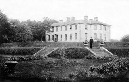
| Clonbrock | Designed by William Leeson and built in the 1780s. In 1837 Lewis recorded it as the seat of Lord Clonbrock. In 1786 Wilson refers to Clonbrock as the seat of R. Dillon. At the time of Griffith's Valuation the house at Clonbrock was valued at £100. In 1906 it was valued at £135. The house was badly damaged by fire in the 1980s and only one wing is now inhabited. |
|
| Clonbrogan | An early 18th century house built by Solomon Watson, the residence of M. Watson in 1814. By the time of Griffith's Valuation John Murphy was the occupier holding the house from Jeremiah Scully. It was valued at £5.14 shillings. This house is still a residence. |
|
| Cloncallick | Built close to Munnilly Lough on the Barrett Lennard estate post Griffith’s Valuation as the building at this site at the time was only valued at £8. It was occupied by Joseph Moorhead. This house has out buildings with a date stone of 1865 and there is a gate lodge at the entrance gate. The Moorehead family were still resident in 1901 and 1911. |
|
| Clonco House (Burke's Court) | Edward Burke was occupying this house valued at £8 at the time of Griffith's Valuation. In 1837 Lewis recorded it as the seat of Ulick Burke. On both the 1st and 25-inch edition Ordnance Survey maps, this house is labelled Burke's Court. In 1906 it was owned by John K. Burke and was valued at £7. The original entrance gates, showing Cloncoe House, are still extant and there is still a house at this site. |
|
| Cloncoskraine | This property was held in fee by John Nugent Humble in 1851 when it was valued at £39. Lewis refers to it as the seat of Lady Nugent Humble in 1837 and notes it was "beautifully situated amid thriving plantations". It was "belonging to the Nugents" according to Charles Smith in 1774. Wilson, writing in 1786, refers to "Clonkosheron, the seat of the late Mr. Shanahan,but now in ruins" which may refer to an earlier house in the locality. In the 1940s the ITA survey noted Cloncoskraine was in the ownership of Miss Nugent, a descendent of the family. The house is still extant and occupied. |
|
| Cloncouse | Thomas Lucas, MD, held this property in fee at the time of Griffith's Valuation, when the house was valued at £7 5s. It is not named on the Ordnance Survey maps and is no longer extant. | |
| Cloncurrin House | This house was not built at the time of the 1st edition 6 inch Ordnance Survey map published in 1836. At the time of Griffith’s Valuation in the 1850s it was occupied by Francis Fitzgerald who held the property from Sir Thomas Barrett-Lennard, when it was valued at £25. Occupied by John A. Moore in 1901 and still in use as a residence. |
|
| Clondagad House | A 19th century house, the home of the Whitstone family, who held the property at the time of Griffith's Valuation from Edward A . Gore. It was valued at £12 and described as a steward's house. The house is occupied and well maintained. |
|
| Clondalever House | Clondalever House is marked on the first edition OS map, but expanded and named on the 25 inch map. At the time of Griffith’s Valuation (publ. 1854) it was valued at £14, occupied by Edward Hope, who held it from George W Mansell or Maunsell (Oakley Park). A house is still located on this site. | |
| Clonderalaw | Weir writes that this house was either built or bought by a branch of the Studderts of county Limerick in the mid 18th century and that it remained their home until the mid 20th century. In 1786 Wilson refers to it as the seat of Mr. Studdert. It was part of the Wandesforde estate in county Clare. It was the home of Mrs Gore (nee Studdert) in the 1940s but according to the Irish Tourist Association surveyor it was not in good repair and "likely to go the way of all the other big houses of Clare". However it has survived into the 21st century with its roof on. In 1894 it was the residence of Captain George Studdert. | |
| Clondrisse House | Clondrisse House, a small building marked on the first edition OS map and named on the 25 inch map. A small two-bay two-storey over basement house built about 1800 and extended in the late 19th century. O’Brien writes that it was the home of Myles O’Reilly in the first two decades of the 19th century. Rev Francis Winter, vicar of the nearby St. John the Baptist's Church of Ireland church was the occupant in the 1840s while Rodney Purdon was resident at the time of Griffith’s Valuation (publ. 1854), holding the house valued at £16, from Samuel Winter. Home of Major John Purdon retired in 1911. |
|
| Clonea Castle | In 1851 Clonea Castle was being leased by Charles Farren, MD, from Rev. Walter McGuire, when it was valued at £20. The 1854 Encumbered Estates sale notice states that Farren's lease was from year to year and he was willing to vacate the premises for the purchaser if necessary. In the 1940s the ITA survey noted that both it and the property then known as Clonea Nursing Home had been built by the Maguire family. The castle was "a square shell on the beach". | |
| Clonea Lower | A house adjacent to Clonea Castle was held in fee by Rev. Walter McGuire at the time of Griffith's Valuation, when it was valued at £10. [Grid Reference is approximate]. Buildings are still extant in the area. | |
| Clonea Mill | In 1850 Judith Ryan was leasing this property from the estate of Sir Benjamin Morris Wall, when it was valued at £21, including a mill. It is labelled Corn Mill on the 1st edition Ordnance Survey map but is not marked on the 25-inch map of the 1890s. | |
| Cloneen | Leet records - Hoare esq as resident at Cloneen, Middleton, in 1814. In the mid 19th century Robert Lunham held a house valued at £20+ from Bingham Sarsfield in this townland. Sarsfield held the property from Abraham Devonsher. When Cloneen was advertised for sale in 1870 it was occupied by Joseph Sheedy. Bingham Sarsfield of Cork owned 266 acres in county Cork in the 1870s. A house is still extant at the site. | |
| Cloneen House | The home of the Meagher family, occupied by William Meagher in 1814 and by Henry C. Meagher in 1850. The property was held from the Earl of Clare and was valued at £18. This house is still occupied. |
|
| Clonervy | In 1814, Clonervy was the home of Richard Blackwood. Located on the estate of Earl Annesley it was vacant at the time of Griffith’s Valuation when its rateable valuation was recorded as £30. George Graham occupied Clonervy in the 1860s and in 1880 it was the residence of the subsheriff John Maxwell James Townley. The Irish Builder records plans for general repairs to Clonervy House for Patrick Lyons in 1912. A smaller building still occupies this site. | |
| Clonervy | In 1814, Clonervy was the home of Richard Blackwood. Located on the estate of Earl Annesley it was vacant at the time of Griffith’s Valuation when its rateable valuation was recorded as £30. George Graham occupied Clonervy in the 1860s and in 1880 it was the residence of the subsheriff John Maxwell James Townley. The Irish Builder records plans for general repairs to Clonervy House for Patrick Lyons in 1912. A smaller building still occupies this site. | |
| Clonfert Cottage | In 1855, a house valued at £8 and belonging to the representatives of Robert Seymour, was leased by James Buchanan. Slater refers to "Clonfert Cottage" as the residence of Robert Seymour in 1846. On the 25-inch maps of 1890s the property at this site is labelled "Constabulary Barracks". | |
| Clonfert Palace | Clonfert Palace was built in the late 17th century and altered in the 18th century. It was the residence of the Church of Ireland bishop of Clonfert until 1836 when that diocese was amalgamated with Killaloe. At the time of Griffith's Valuation, John E. Trench was leasing the property valued at £20 from the Ecclesiastical Commissioners in the townland of Clonfert Demesne, barony of Longford, county Galway. In 1906 it was in the ownership of Charles O'Hara Trench. Later occupied by the British fascist leader, Oswald Mosley. It was damaged by fire in 1954 and has been derelict since. |
|
| Clonfinane House | In 1841 the Ordnance Survey Name Books refer to a house in the townland of Clonfinane as Moorefield House. There is reference to a communication from the Earl of Portarlington that he did not know of any such place on his estate with a following note by John O'Donovan stating "but your tenant built a house and gave it a name"! The house is described as " a good dwelling house, the residence of Maunsell Antisell". However, on the 1st edition Ordnance Survey map, the house is labelled "Clonfinane House" perhaps indicating that Lord Portarlington prevailed. At the time of Griffith's Valuation, the house in this townland is occupied by the representatives of Jonathan Walsh and valued at almost £4. A house and farm are still extant at the site. | |
| Clonfinane House | In 1841 the Ordnance Survey Name Books refer to a house in the townland of Clonfinane as Moorefield House. There is reference to a communication from the Earl of Portarlington that he did not know of any such place on his estate with a following note by John O'Donovan stating "but your tenant built a house and gave it a name"! The house is described as " a good dwelling house, the residence of Maunsell Antisell". However, on the 1st edition Ordnance Survey map, the house is labelled "Clonfinane House" perhaps indicating that Lord Portarlington prevailed. At the time of Griffith's Valuation, the house in this townland is occupied by the representatives of Jonathan Walsh and valued at almost £4. A house and farm are still extant at the site. | |
| Clongowna House | In 1840, he Ordnance Survey Name Books refer to this property as "Mount Ormond, a good dwelling house in a demesne of the same name, the residence of Rev. Mr. Troak" It is labelled on both the First and 25-edtion Ordnance Survey maps, however, as Clongowna House. Occupied by the Reverend Mr Troke in 1837 and by John Brereton at the time of Griffith's Valuation. John Brereton held the property in fee and the house was valued at £21. Still occupied by the Breretons in the 1870s. A house is still extant at this site. | |
| Clonkeen Cottage | This house was not built at the time of the first Ordnance survey in the 1830s. It was located on the Lentaigne estate just north of the town of Clones. William Tugman was the occupant at the time of Griffith’s Valuation when the house was valued at £16 and held from Samuel Nicholl. A building still occupies this site. | |
| Clonkeen House (Barrington) | Croker Barrington, second son of Sir Croker Barrington, was the occupant of a mansion house at Clonkeen (Barrington) in 1906, valued at £48. The Barringtons owned a house in this area at the time of Griffith's Valuation which was valued at almost £10. This older property is known as Clonkeen House and was enlarged later in the nineteenth century. The 25-inch Ordnance Survey Map of the 1890s shows a second property, labelled Barrington's Bridge House [R683547]. This latter property is locally known as The Red House. Houses are still extant at both sites. Clonkeen House was offered for sale in 2013. |

|
| Clonkerdin House | Mrs Catherine Quinlan was leasing this property from Lord Stuart de Decies in 1851 when it was valued at £30. It is still extant and occupied. In 2014 it was offered for sale. |

|
| Clonleigh (Raphoe North) | Reverend William Knox held this property in fee at the time of Griffiths Valuation in the 1850s when it was valued at £70. In 1906 it was the property of William Knox and valued at £73. It is no longer extant. | |
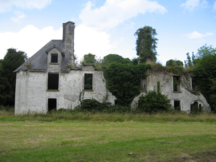
| Clonlost | Clonlost house is shown amidst a large demesne on the first OS map. The Nugent family were settled at Clonlost from the 17th century. The house was a two-storey, five-bay, late 18th century building (O’Brien). In 1814 it was the home of Lt Col Nugent. Lewis records it as the ‘ancient family seat of J Nugent’. At the time of Griffith’s Valuation (publ. 1854) Captain John J Nugent held it in fee when the house was valued at £40 and he owned an estate of over 3,000 acres in the 1870s. His daughter married William Lamb Palmer of Rahan, Co Kildare and it was their son Charles Colley Palmer who inherited Clonlost. Members of the Palmer family were still resident in the early years of the 20th century. The house is now a ruin. | |
| Clonmacken | Built in 1700 by Reverend Edmund Palmer according to the Ordnance Survey Field Book, this two-storey house was occupied by Henry D'Esterre in 1814, by Captain Vereker in 1834 and by 1839 was the seat of John Brown Finch. In the early 1850s it was the residence of John Sharp, situated on the Lansdowne estate, it was held from Lawrence Kelly. | |
| Clonmaine | At the time of Griffith's Valuation William Abbot held this house valued at £15 from Robert U.P. Fitzgerald. |
|
| Clonmaskill | Clonmaskill House is a three-bay two-storey house with an attic level, built about 1790. In 1814 and 1837 it was the residence of Laurence Lloyd Henry, who died in 1846. His widow Margaret was the occupant at the time of Griffith’s Valuation (publ. 1854) when the house was valued at £13.5 and held from the Hon W F F Tighe. Details of the Henry family are recorded on a table tomb in St Mary’s graveyard, Devlin. The 1911 census records a farmer Thomas Tormey residing in a class one house in Clonmaskill. The house is now surrounded by extensive farm buildings. For members of the Henry family see https://www.from-ireland.net/category/gravestones-transcriptions/page/10/ |
|
| Clonmeen House | Built in 1893 for Stephen Grehan and designed by George Ashlin. This house remained in the possession of the Grehan family until the 1970s. In the 1940s the Irish Tourist Association Survey noted it as the residence of Major Grehan. Late in the twentieth century it functioned as a hotel for some time but has now returned to private ownership. |

|
| Clonmeen Lodge | Hajba writes that this house was the home of Cornelius O'Callaghan in 1750. In 1786 Wilson refers to "Bantyre" as the seat of Mr. Callaghan. Viscount Lismore is recorded as proprietor of Clonmeen in 1814. At the time of Griffith's Valuation Clonmeen Lodge was occupied by George Grehan and held from Viscount Lismore. It was valued at £7+. The Grehans continued to use this house as a secondary residence while their main residence was in Dublin. In 1893 a much larger house, Clonmeen House, was built close to the lodge. In the 1940s the Irish Tourist Association Survey noted "The Lodge, Banteer" as the residence of Jerome O'Callaghan and stated that the house had originally been built by the Nash family as a fishing lodge. A building is still extant at the site. | |
| Clonmoney West | An early 18th century house, built and owned by the Westropps until the 20th century. The O'Donnells were resident at the end of the 18th century. It was leased to Henry White in 1814 and to D. Canny in 1837. Matthew Canny held Clonmoney from John Westropp in the mid 19th century, when the property was valued at £25. The Cannys subleased the property to Michael Macnamara. The executors of Macnamara's will advertised the sale of his interest in Clonmoney in January 1880. The original house is not extant now. |

|
| Clonmoyle | In 1837 this house was the home of Charles Colthurst, a younger son of John Colthurst and his wife, Jane Bowen. At the time of Griffith's Valuation Jonathon Bruce was the occupier. He held the house valued at £35 from Charles Colthurst. Henry Leader of Clonmoyle, Coachford, owned 2,418 acres in county Cork in the 1870s. The Irish Tourist Association survey of the early 1940s mentions that it was the residence of Mrs.Young, the owner of Clonmoyle Flour Mills and that it had previously been the home of Harry Leader. It is now a ruin. | |
| Clonmoyle House | Clonmoyle House, Tullanisky, is a two-storey, three-bay over basement house. The present house was built after 1838 and replaced an earlier house as recorded on the first edition OS map. In 1814 the older house was the home of David Jones. O’Brien writes that David Jones married Frances, daughter of Alexander Swift of Lynn in 1771. By the time of Griffith’s Valuation (publ. 1854) Charles Joley or Joly was resident holding the house valued at £35 from Thomas Walsh. Henry E Joly was in possession in the 1870s. |
|
| Clonmult | The Powers appear to be associated with Clonmult from the late 17th century. In the first half of the 19th century Pierce Power was resident, the house being valued at £23 in the early 1850s and held from Edward Phayre. A Shaw Smith home in the second half of the 19th century. Louis K. Smyth is recorded as the occupant in 1906 when the buildings were valued at £16. 15 shillings. |
|
| Clonroad | A 17th century house in the possession of the Gore family from 1712 until 1852. The house was close to the River Fergus and had a brewery beside it. At the time of Griffith's Valuation the Gores were leasing the house and brewery to William Digges and the house was occupied by Henry Greene. In the 20th century the house which was rebuilt and extended in the mid 19th century belonged to the Knox and Merry families. | |
| Clonshavoy | Located on the Barrington estate this house was occupied by Caleb Powell and valued at £15 at the time of Griffith's Valuation. Bence Jones describes Clonshavoy as a single storey early 19th century house in the "cottage" style. In the 20th century it was the home of the last Barrington to live in the Limerick area. The Irish Tourist Association surveyor writes in 1944 that the house was interesting as it was the remains of a very old Elizabethan house. He says that more than half the house was pulled down as it was unsafe "and the present eastern wing is a reconstruction". This house is still extant. |

|
| Clonshire | Occupied by George Fosberry in 1814 and by J. Dickson in 1837. This one storey house was described as a ''comfortable slated cottage built in 1812 by the present occupier Col. John Dickson'' [brother of the Reverend Richard]. This house, valued at £22 at the time of Griffith's Valuation, was occupied by Samuel D. Power who held it from John Pigott. Clonshire is now the location of a large equestrian centre. Owned by the Greenall family, Lord Daresbury, in the 20th century. [The Greenalls also bought Mount Coote]. |

|
| Clonsingle | A house situated on the Tipperary/Limerick county border, occupied by R. Young in 1837 and by Robert Young in the early 1850s, when it was valued at £30 and held in fee. Robert Young was still resident in the 1870s. A house is still located at this site. | |
| Clontaff | Richard Townsend was leasing this property from Esther Horan at the time of Griffith's Valuation, when it was valued at £19. Lewis also records it as the seat of R. Townsend in 1837. | |
| Clontead More House | At the time of Griffith's Valuation, Herbert Gillman was leasing a property valued at £14 from Edward Murphy. This house was built after the publication of the 1st edition Ordnance Survey map. The Irish Tourist Association survey refers to "Clontead" as the former residence of the historian, Herbert Webb Gillman,(1832-1898). It is still extant and seems to have become known as Clontead More House. |
|
| Clontoe | A house valued at £7 occupied and held in fee by John Wright at the time of Griffith’s Valuation (circa 1860). Still in the possession of the representatives of J. Wright at the beginning of the 20th century, it was occupied by the Humphries family. | |
| Clonwhelan | Richard White held this property in fee at the time of Griffiths Valuation when it was valued at £15. In 1814 Leet referred to it as the residence of Miss Godley. James Bond was the occupier at the time of the initial valuation in 1839 when it was valued at £12. It is still extant |
|
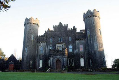
| Clonyn Castle | Clonyn Castle, five-bay two-and three-storey over basement Gothic Revival-style castle, built between 1867-1876 to the design of John McCurdy (1823-85) for Lord and Lady Greville-Nugent, both of whom died in 1883. Their sons followed careers in England and Australia and the house was only occupied by servants at the time of the 1901 census. Sold by the Grevilles in the 1920s this building remains a private residence. |
|
| Clonyn House | Clonyn/Clonin House, (also known as Clonyn or Delvin Castle) is named on the first edition OS map with a riding school to the rear and is recorded as ‘in ruins’ on the 25 inch map. A plaque with the crest of the Nugent family on the façade dates the building 1680. Later extensions to the house dating from the early 18th century to the early 19th century are evident. This was the home of the Earls and Marquess of Westmeath and in 1837 is described as such by Lewis. The first and only Marquess of Westmeath died in 1871 and his estates were inherited by his daughter Rosa, who was married to Lord Greville. However, by the time of Griffith’s Valuation (publ. 1854) Lord Greville was already in possession of Clonyn holding it in fee and valued at £60. By 1906 the buildings were valued at £130.3 and held with 824 acres of untenanted land however the estate was ‘In Chancery’. The Hon Priscilla Nugent was the occupant. The house became a ruin some years later and is now surrounded by Delvin Golf course. | |
| Cloon | In 1814 Cloon House is recorded as the seat of B. Eyre. Lewis records the house as that of Burke Eyre in 1837. At the time of Griffith's Valuation Cloon House was occupied by Henry Lahiff when it was valued at £15. It is still extant and occupied by his descendents. |
|
| Cloon (Raphoe) | Robert McFarlane was leasing this property from Anne Law at the time of Griffiths Valuation in the 1850s, when it was valued at £16. Labelled as Cloon on all editions of the Ordnance Survey maps. Farm building occupy the site of the original house now. | |
| Cloonacauneen Castle | Muriel L. Athy writes that the castle was occupied by Martin Blake in 1835, although it is recorded in the Ordnance Survey Name Books as the property of Mr. French. The property later passed into the hands of Mr Fair "who built against it a Tudor house", his descendant Dr Fair of Ballinasloe sold it to the Estates Commissioners". Owned by James Malley in the early 20th century. Described by Bence Jones as a tower house with an attached wing. | |
| Cloonagh | The home of a branch of the Fallon family from the mid 18th century. Wilson refers to it as the seat of John Fallon in 1786. Occupied by James Mannion in 1814 and described in the 1830s as "a well built modern mansion forming three fourths of a cross". Occupied by James Bailey at the time of Griffith's Valuation, when it was part of the Trench estate. It is now a ruin. | |
| Cloonagh Lodge | An extensive complex of mills is shown at this location on the 1st edition Ordnance Survey map of 1840, including two flour mills. At the time of Griffith's Valuation, Matthias McDonnell was leasing mill properties, valued at £67, from the estate of the Marquis of Sligo. In addition he was leasing a house valued at £4. Cloonagh Lodge is shown on the 25-inch Ordnance Survey map of the 1890s. A house is still extant at the site. . | |
| Cloonahee | Residence of Gilbert Conry in 1814 and of John Conroy esq in 1822. According to a note with the sale rental of 1853 the house was accidently burnt and a good farm house built as a replacement. The home of John Heague in the mid 19th century. Occupied by Richard Hague and valued at £40 in 1906. |
|
| Cloonalassan House | Lord Monteagle was leasing this property to John Giles at the time of Griffith's Valuation, when it was valued at £8 5s, on a demesne of 123 acres, some of which extended into Ballycrispin townland. Lewis mentions, in 1837, that Ballycrispin was formerly the residence of the Spring-Rice ancestors. It is not shown on the later 25-inch Ordnance Survey map of the 1890s. | |
| Cloonamahon | In 1854 when the estate was offered for sale by Thomas James Meredith the house was described as "a good slated dwelling-house..somewhat out of repair, but with a little outlay, it could be made very comfortable". In 1906 Dr. Henry Tweedy was the owner of buildings valued at £50 at the site. Following the departure of the Tweedy family the property was used as a sanitorium and later a retreat centre. McTernan notes that the original house was demolished in 1976 and replaced by modern buildings. Most of the site is now occupied by a Health Service facility. | |
| Cloonatleva | Samuel Johnston was leasing a property valued at almost £5 at Cloonatleva Lower, barony of Kilconnell, from the Hodson estate at the time of Griffith's Valuation. The original building is not shown on the later 25-inch Ordnance Survey map of the 1890s. Modern farm buildings occupy the site now. | |
| Cloonatleva Mill | James Tyrrell was leasing a house and mill, valued at £6, together with land, at Cloonatleva, barony of Kilconnell, from the Hodson estate at the time of Griffith's Valuation. The building is described as "disused" on the 25-inch Ordnance Survey map of the 1890s. | |
| Cloonbalt | Hugh Peatton was leasing this property from Reverend Gray Porter at the time of Griffiths Valuation in the early 1860s, when it was valued at £23. In the 1830s the Ordnance Survey Name Books noted it as the seat of Richard Armstrong. In 1837 Lewis referred to “Clonbalt” as te property of the Earl of Belmore. A house is still extant at the site. | |
| Cloonbarry | At the time of Griffith's Valuation Cloonbarry was occupied by George Knox and was valued at £27.It was offered for sale in July 1866 by Roger Dodwell Robinson, when it was described as "an excellent dwelling house, erected by the owner's father at an expense of £2000". In 1906 Henry McCarrick was the owner of buildings at Cloonbarry, barony of Leyny, valued at £22. McTernan states that it had fallen into disrepair by the 1950s and was subsequently demolished. | |
| Cloonbeg | A property described as offices, the property of R.H. Gumbleton, was valued at £15 5s at the time of Griffith's Valuation. In 1906 this property was owned by Basil Orpin with a valuation of £16. Some of the buildings still remain at the site. | |
| Cloonbonny | Cloonboony is a five-bay single-storey over basement house on a U-shaped plan, built c.1790, having two two-storey returns (boi). Cloonbonny House was originally built by the Longworth family as a dower house to Glynwood House (O’Brien). Edward Marsh was resident at the time of Griffith’s Valuation (publ. 1854) when the house was valued at £11 and was held from Francis Longworth. The Johnson and Byrne families have occupied the house from 1869 until the present day. |
|
| Cloonbony House | In 1837 Lewis refers to Cloonbony as the seat of G. Davys. Leet noted it as the residence of William James Davys in 1814. At the time of Griffiths Valuation in the early 1850s it was leased by Francis Davys from Luke White’s estate, when it was valued at £10. The National Built Heritage Service suggests it was built c.1800. It is still extant and occupied. |
|
| Cloonboy House | The home of John Coghlan at the time of Griffith's Valuation, held from the Lynch Blosse estate when the house was valued at £10. It is still extant. | |
| Clooncah | A house built after the publication of the 1st Ordnance Survey map, at the time of Griffith's Valuation it was by John Love. The house was valued at £12 and held from John Armstrong. In 1885 Walford describes John Armstrong as a magistrate for county Galway, and of "Clooncagh and South Hill, Clifden". The site at Clooncah is now occupied by farm buildings. | |
| Clooncah | In 1778, Clooncah was a property of the Daly family. and Wilson mentions it as the seat of Peter Daly in 1786. Lewis records it as the seat of P. Daly in 1837. William Galway held this property at the time of Griffith's Valuation, when it was valued at £30. According to local tradition, Clooncah House was demolished in the early twentieth century and the stone used in the construction of the new National School at Attymon. | |
| Clooncahir | John Walsh was the lessor of a vacant house valued at £12 at Clooncahir, barony of Mohill at the time of Griffith's Valuation. He was leasing lands in the same area from the Crofton estate. A house still exists at the site. | |
| Clooncallow House | Clooncallow House was occupied by Thomas Bredin at the time of Griffiths Valuation in the 1850s when it was valued at £12. He was also noted by the valuers as the occupier in 1840, though his name was spelt 'Braydon' at the time. Thomas Bradon is also recorded as a landholder in Clooncallow in the Tithe Applotment records in 1829. It is still extant and occupied. |
|
| Clooncannon/Cloncannon/Runnamead | Far Kelly was resident at Cloncannon in 1749. It is described in the Ordnance Survey Name Books as the residence of William Kelly. This property was offered for sale in the Encumbered Estates in July 1850. At that time it was occupied by Mathew C. Browne. John and Edward Lennon were occupying this property, valued at £9, at the time of Griffith's Valuation. It was part of a holding of almost 400 acres. Joseph Trumperant Potts laid the foundation stone for his house known as Runnymeade in 1866 (''Saunders Newsletter'', 23 June 1866). It is labelled as Runnamead House on the 25-inch Ordnance Survey map of the 1890s. In 1906 a house valued at £10 at Clooncannon Kelly was part of the Clonbrock estate together with almost 400 acres of untenanted land.. It is no longer extant. | |
| Clooncona | Laurence Mitchell was leasing a house valued at almost £4 at Clooncona, barony of Longford, from the Clanricarde estate at the time of Griffith's Valuation. There is still an occupied house at this site which in 2007 was offered for sale. Extensive nurseries are shown in this location on the 1st edition OS Map. |
|
| Cloonconra | A house in the townland of Cloonconra, parish of Clonfert, barony of Longford, was valued at £10. It was part of Archdeacon Butson's estate at the time of Griffith's Valuation. It is labelled Cloonconra Farm on the 25-inch Ordnance Survey map of the 1890s. A farm still exists at the site. | |
| Clooncorick Castle | Formerly an O'Rourke castle, Clooncorrick was held by several other families, notably the Irwins, before being bought by Pierce Simpson in 1835. In 1814 it is recorded as the residence of Rev. Agar. At the time of Griffith's Valuation it was being leased by Pierce Simpson from the Ormsby Gore estate and was valued at £40. Lewis also records it as the seat of the Simpson family in 1837. In the 1930s the castle was dismantled and the fittings sold. The ITA survey in the 1940s recorded that the castle had recently been demolished. | |
| Clooncormick | Home of the Gildea family in the 19th century and of the McCartan family in the late 20th century until it was destroyed by a fire. Francis Knox Gildea was leasing from James Knox Gildea at the time of Griffith's Valuation, when the property was valued at £45. No trace of the house remains but much of the stable yard is still extant. |
|
| Clooncunny | At the time of Griffith's Valuation Thomas Rice was leasing a property valued at £5 together with over 150 acres at Clooncunny, barony of Leyny, from the Kirkwood estate. Lewis records Thomas Rice's seat as Achonry in 1837. A house and farm are still extant at this location. | |
| Clooncurra | In 1786 Wilson states that Clooncurra was the seat of Mr. Hussey. At the time of Griffith's Valuation, this townland was part of the Hickson estate and let in two substantial farms, with houses valued at £1 5s and £1 10s respectively. Modern farm buildings are visible at the site. | |
| Cloondoyle | In 1786, Wilson refers to "Clondowel" as the seat of Mr. Blake. At the time of Griffith's Valuation it was occupied by Thomas Kelly and held from [his father] Bartholomew Kelly. The house was valued at £8. It is labelled Clondoyle House on both the First and 25-inch editions of the Ordnance Survey map. A house still exists at the site. |
|
| Cloone Grange | A house built after the publication of the first Ordnance Survey Map. At the time of Griffith's Valuation Rev. John Carson was occupying the property which was valued at £25. In 1906 William H. White was the owner of this house, valued at £28. The site of the original house is now occupied by farm buildings. | |
| Cloonee | A house built circa 1760, sometimes known as Lakeview. It was occupied in the late 1770s by a member of the Browne family and from the early 19th century by the Blakes. Thomas Walsh was the occupier at the time of Griffith's Valuation. He held the property from Colonel Charles Knox. Cloonee was the home of William Creagh Burke in the early 20th century. The "Connaught Telegraph" of 9 March 1935 reported the sudden death of William C. Burke of Lakeview in the Main Street of Ballinrobe when a fair was taking place. The property passed by marriage to the Ruttledge family of Bloomfield. see www.clooneehouse.com/ |
|
| Clooney House | Originally a 17th century house, the home of the Bindon family, it was burnt in the 19th century. Lewis refers to "Clonie, the demesne of Burton Bindon" in 1837. At the time of Griffith's Valuation the house was unoccupied and William S. Vesey Fitzgerald was the immediate lessor. Rebuilt in the latter half of the 19th century by Joseph Hall and his wife Ellen Bindon. The house was bought by the Tuckeys following the death of Joseph Hall in 1907, the land was divided in the 1920s and the house went to ruin. |
|
| Cloonfad | Home of the Browne family in the 18th and 19th centuries. | |
| Cloonfin House | John Thompson held this property in fee at the time of Griffiths Valuation in the early 1850s, when it was valued at £40. It has been demolished but a number of estate buildings survive. |