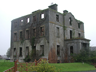
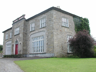
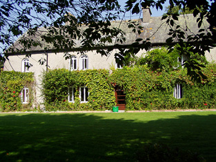
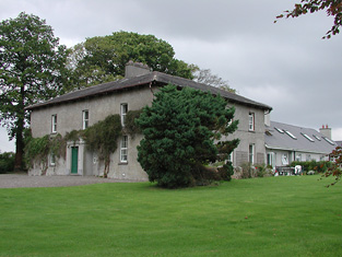
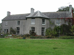
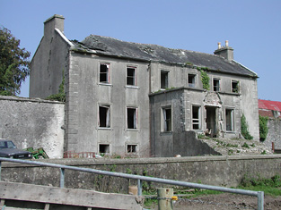
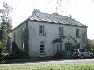
Knockane
Houses within 15km of this house
Displaying 118 houses.
Houses within 15km of Knockane
Displaying 118 houses.
| House name | Description | |
|---|---|---|
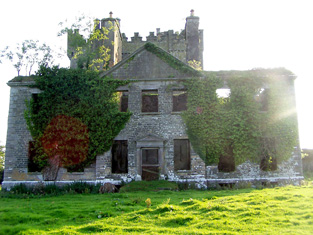
| Solsborough | In 1786 Wilson refers to "Sallborough" as the seat of Mr. Poe. T. Poe was residing at Salisboro in 1837. At the time of Griffith's Valuation (1850) James J. Poe held the property from the Court of Exchequer. The buildings were valued at £41. At the time of the 1852 sale James J. Poe was the tenant holding the property on a 7 year lease pending the cause of Crofts v Poe. Henry H. Poe of Solsborough owned 314 acres in county Tipperary in the 1870s. This house is now a ruin. |
|
| Knockanacree Wood House | A house valued at £17+, occupied by Hawtrey Andrews and held from the Reverend Frederick F. Trench in the mid 19th century. Walford states that Hawtrey Andrews was the second son of Maunsell Andrews of Rathanny. This house is now demolished. | |
| Fort William | The Ordnance Survey Name Books refer to correspondence with John Cooke in the parish of Glenkeen in 1840. This house was occupied by Mrs Margaret Cooke in the mid 19th century and held from the Earl of Portarlington, valued at £13.10 shillings. John W. Cooke was resident here in the 1870s. Fort William is still extant and occupied. |
|
| Summerhill | Richard Bourke was resident at Summer-hill, Burris-o-leagh, in 1814 but by 1837 J.H. Harden was the proprietor. At the time of Griffith's Valuation Charles F. Harden held the house, valued at £11, from John H. Harden. Buildings are still extant at this site. | |
| Fishmoyne | A junior branch of the Carden family lived at Fishmoyne from the mid 18th century. Bence Jones writes that the house was built in the 19th century replacing the original house which was destroyed by fire. Wilson, writing in 1786, notes Fishmoynne as the seat of Mr. Carden. A Mrs Butler was resident in 1814 and R. Minchin Carden in 1837. Richard Carden held the property in fee in the early 1850s when it was valued at £56.17 shillings. This house remained the property of the Carden family until 1955. The Irish Tourish Association survey records the house as "idle and locked up" in the early 1940s. Fishmoyne is no longer extant. | |
| Oldtown | The home of the Bennett family in the 19th century, occupied by Theophilus Bennett in 1814 and by John Bennett in the early 1850s. The property was held from the Cardens and the buildings were valued at £19+ in the mid 19th century. This house was demolished by the early 20th century. | |
| Templemore Abbey/The Priory | In 1837 Lewis refers to the Castle at Templemore being the residence of the Carden family "up to about a century ago" when it was accidentially burnt by fire. He states that more recently the Carden family had lived at the Priory, a house marked on the first edition Ordnance Survey map and valued at £96+ at the time of Griffith's Valuation. This house was rebuilt in the 1860s and was burnt in the early 1920s. The stableyard is still extant. In 1894 Slater had referred to Templemore Abbey as the seat of Sir John C. Carden. |
|
| Green Hills | The home of a branch of the Minchin family in the 18th and for part of the 19th centuries. The house was occupied by the Reverend William Minchin in the first half of the 19th century. It was valued at £34.15 shillings at the time of Griffith's Valuation and held in fee. The sale rental of 1851 describes the house as large and commodious and in good repair. Bought by a brother of one of the Reverend Minchin's son in laws Montague Blackett. This house no longer exists. | |
| Barnane | Barnane, at the foot of the Devil's Bit mountain, was the seat of a branch of the Carden family. Occupied by John Carden in 1814 and by R. Carden in 1837. John Carden held the property in fee with 1,430 acres at the time of Griffith's Valuation. Andrew M. Carden was resident at Barnane in 1906 when the buildings were valued at £120. The house is now a ruin. |
|
| Derrylahan House | This house was the home of the Mason family in the 19th century, occupied by James Mason in 1814 and by William Mason in the early 1850s. The buildings were valued at £10 and held from Peter D. La Touche. William Mason of Derrylahan owned 228 acres in the 1870s. A house and farm are still extant at the site. | |
| Longford | The Ordnance Survey Name Books refer to Robert Lloyd as the proprietor of Longford House in the 1840s and it was occupied by him and held from Thomas Prince Lloyd at the time of Griffith's Valuation when the house was valued at £16. A mansion house in the townland of Longford valued at £34+ was occupied by James Lloyd in 1906. A building is still located at this site. | |
| Mountfrisco | Mount-fresco was occupied by Thomas Lloyd in 1814 and by Horatio Lloyd in 1837 and in the early 1850s. The house was then valued at £10 and held in fee. This house is no longer extant. | |
| Whiteville | Leet records Mr Stephen Ryan as the resident of White-ville, Moneygall, in 1814. The Ordnance Survey Name Books refer to Whiteville as the residence of Robert White. Benjamin White was the occupier at the time of Griffith's Valuation. He held the property in fee and the buildings were valued at £13+. This house marked on the first edition Ordnance Survey map was replaced by a later house known as Knockanroger House and located slightly to the north of the original structure. A house is still extant at the site. | |
| Dangansallagh | Lewis records J. Lewis as resident at Dangan Lodge in 1837 and Griffith's Valuation records James Middleton holding the lodge valued at £10+ and 266 acres in fee. It is now a ruin. | |
| Ash Park | Ash Park or Park was the home of the Butler family in the 18th and 19th centuries. Occupied by James Butler in 1814 and 1837 and by Captain James Butler at the time of Griffith's Valuation. The buildings were valued at £35+ and held in fee. This house no longer exists. | |
| Skehanagh | George Lloyd was living in a house valued at £16 at Skehanagh North in the mid 19th century.The Ordnance Survey Name Books note "Skehana" as the residence of George Richard Lloyd in 1840. In the 1870s Horatio M. Lloyd of Skehana, Templemore owned 182 acres in county Tipperary. Catherine Lloyd was resident in 1906. This house burnt down and the present building on the same site dates from the early 20th century. |

|
| Killoskehane | This house was the seat of the Willington family. In 1837 Lewis wrote that Killoskehane Castle "includes part of the ancient castle in the modern mansion". The property was held by John Willington in fee at the time of Griffith's Valuation when the buildings were valued at £29+. Edward D. Martin was the occupier of Killoskehane in 1906 and William Costigan in the 1940s. The building is still extant and occupied. |

|
| Lisduff | The Smiths were resident at Lisduffe from the early 18th century when Jeremiah Lalor married the daughter of Samuel Smith of Lisduffe. From this couple descend the Lalors of Long Orchard. Samuel Smyth was the occupant of Lisduff in 1814 and William Smith in 1837. Griffith's Valuation records John Minchin as resident. The buildings were then valued at £33 and held from Admiral Darby. This house is still a residence. |
|
| New Grove | Leet and Lewis both record Westropp Smith as the occupier of New Grove, Roscrea, in 1814 and 1837. John Minchin was the occupier at the time of Griffith's Valuation. He held the property, valued at £19, from Henry B. Minchin. A building is still extant at this site. | |
| Lloydsborough | In 1786 Wilson mentions that Lloydsborough was the seat of Mr. Carden. This house was the seat of the Lloyd family in the 19th century. In 1814 Henry Lloyd was resident and in 1837 John Lloyd was the occupant. Griffith's Valuation records John as holder of the property in fee and the buildings were valued at £44+. Lloydsborough was still in the possession of a branch of the Lloyd family in the early 20th century. Still extant and occupied, Lloydsborough was offered for sale in 2014. |

|
| Honeymount | Honeymount was occupied by John Evans in 1814 and by Captain Lloyd in the early 1850s, when it was valued at £11.10 shillings and held from Leonard Williams. Robert Lloyd is recorded as the tenant in the sale notice of 1856. Honeymount, part of the estate of the Mahons of Co Clare, was advertised for sale in July 1871. A house is still extant at the site. In 2014 it was offered for sale. |

|
| Monaquil | Burke's ''Landed Gentry of Ireland'' (1904) records Philip Going of Monaquil, sixth son of Robert and Jane Going. In 1767 Philip married Grace Bernard. Their grandson, Reverend Philip Going Atkins Going, succeeded to the Monaquil property by the will of his maternal grandfather, who died in 1820. Monaquil was occupied by the Atkins family in 1837. In 1840 the Ordnance Survey Name Books record that "Mr. O'Shea, proprietor, states that he has nothing to do now ith Monaquil, it is under the Courts" and that the house was then occupied by a Mrs. Bennett. It was vacant at the time of Griffith's Valuation. when Reverend Hastings Atkins was the immediate lessor and the house was valued at £19. The Butler sale rental of 1866 records a fee farm grant dated 19 May 1859, John Butler to Reverend Philip Going Atkins Going. The Atkins sale rental of 1877 records the leasing of Monaquil to Robert William Henry Roe in 1864. The original house marked on the first edition Ordnance Survey Map was replaced by another house slightly to the north in the late 19th century. | |
| Bantis | In 1814 Mr Kennedy is recorded as the proprietor of Bantis and Lewis mentions the extensive brewery of Edward Kennedy at Bantis in 1837. The Ordnance Survey Name Books record Bantis as "a neat dwelling house", the residence of Edward Kennedy. Buildings valued at £31+ and 526 acres at Bantis were held from the Honourable O.F.G. Toler by Edward, James, Denis, John and Patrick Kennedy and Henry Fitzgerald at the time of Griffith's Valuation. A house is still extant at the site. | |
| Lismore | A house on the Toler estate, occupied by John Pepper and valued at £13+ in the mid 19th century. A building is still located at this site. | |
| Lissanisky | The home of a branch of the Pepper family in the 19th century, occupied by Simon Pepper in 1814, by R. Smithwick in 1837. The Ordnance Survey Name Books refer to it as " a good dwelling house, the residence of Mr. Pepper". It was occupied by Theobald Pepper and Brothers in the early 1850s. This house was held from the Honourable O.F.G. Toler and was valued at £25.10 shillings. It is still extant and occupied. |
|
| Camira | Occupied by the Reverend P. Bolton in 1837 and by William Jackson in the early 1850s, when the house valued at £11.14 shillings was held from Anne Crawford. In the possession of the Cole Bowen family in the later 19th century. This house no longer exists although a building is still located at the site. http://www.askaboutireland.ie/reading-room/history-heritage/big-houses-of-ireland/the-cole-bowen-estate/bowen-family-history/ | |
| Hermitage | This house was occupied by J.A. [John Andrew] Jackson at the time of Griffith's Valuation and held from his father Major Jackson. The house was valued at £20.16 shillings and was located close to the River Ollatrim. This house was renovated in the early 21st century. |
|
| Mount Pleasant | The main home of the Jackson family in the 19th century, occupied by John Short in 1814, by Captain Jackson in the 1830s and by Major Jackson in the early 1850s. The house with 448 acres was held from John Willington. The buildings were valued at £29+. Francis Freeman was the tenant in 1870. This house no longer exists. | |
| Castle Willington | Castle Willington was the seat of a junior branch of the Willington family of Killoskehane Castle. In 1786 Wilson refers to it as the seat of Mr. Willington. The Ordnance Survey Name Books note it as the seat of James Willington. Valued at £38+ it was held by James Willington in fee at the time of Griffith's Valuation. Alice C. Langford occupied this house valued at £20 in 1906. She was a daughter of John Willington and had married in 1877 Charles C. Coplen Langford. This house of 3 storys with tower house attached is still a residence. |

|
| Rapla | Rapla was a Freeman home in the 18th century and was inhabited for a time by the Otways, Phoebe Otway having married Daniel Freeman of Rapla. Wilson, writing in 1786, refers to Rapla as the seat of Mr. Willington. Jonathan Willington, younger brother of John of Killoskehane, was residing at Rapla in 1814 and William Cooper Crawford in 1837. William Cooper Crawford married Sophia Morgan [nee Willington] as her second husband. By the early 1850s John Tuthill was resident holding the house valued at £42+ from William Cooper Crawford. The sale rental of 1850 describes Rapla as a first class house held on a lease for 7 years from the Court of Chancery to John Tuthill. This house no longer exists. |

|
| Donnybrook | This house was the seat of a branch of the Poe family in the 18th and 19th centuries. William Poe was resident in 1814 and Lewis records him as the proprietor but the house was occupied by a tenant. The Ordnance Survey Name Books mention William Jackson as the occupier and describe the house as "large and commodious". At the time of Griffith's Valuation William Poe held the property in fee, the buildings were valued at £16.14 shillings. Donnybrook is still extant. |
|
| Wilton | This house located close to Donnybrook was vacant at the time of Griffith's Valuation and held by William Poe. It was valued at £10+. Earlier, in 1839, the Ordnance Survey Name books had noted it as the residence of John Poe but "out of repair at present". It no longer exists. | |
| Falleen | The home of the Hawkeshaw family in the 19th century, held from the Bowens of Bowens Court. Benjamin Hawkeshaw is recorded as the occupant in 1814 and in the early 1850s when the house was valued at £13.14 shillings. G. Riall was resident in 1837. The Ordnance Survey Name Books refer to Falleen as the seat of James Bennett in 1839. A house is still extant at the site. | |
| Pallas | The home of the Short family in the first half of the 19th century held from the Bowens of Bowens Court. John Short was resident in 1814 and 1837. The Ordnance Survey Name Books describe it as "a commodious dwelling with pretty demesne". It was occupied by Edmund Short at the time of Griffith's Valuation when the buildings were valued at £10. A farm is located at the site. | |
| Debsborough | The seat of the Bayly family in the 18th and 19th centuries, occupied by successive John Bayly/Bailys and held in fee. The Ordnance Survey Name Books describe it as "a large demesnewith commodious dwelling house" in 1840. In the mid 19th century the house was valued at £38+ and in 1906 at £65. A building is still located at this site. | |
| Ballynaclogh House | The home of Richard Uniacke Bayly and his family in the 19th century, held from his brother John. The house was valued at almost £17 at the time of Griffith's Valuation. This house is still extant and occupied. |
|
| Bayly's Farm | The home of Lancelot P. Bayly and his family in the 19th century, held from his brother John. The house was valued at £13.6 shillings at the time of Griffith's Valuation. This house with modern additions still functions as a residence. It also offers guest accommodation. See www.baylyfarm.ie. |
|
| Coolagh | Coolagh is described in the Ordnance Survey Name Books as "a good dwelling house in a small demesne with plantation and ornamental ground" in 1841. It was occupied by John Brindley in the mid 19th century. Valued at £12+ it was held from the Very Reverend Dean Head. It is still extant. | |
| Happygrove House | In 1840 the Ordnance Survey Name Books refer to "Happy Grove" as "the name of the place and residence of Mr. John Brindley" and gives details of the oatmeal mill in the demesne. Samuel Brindley was the proprietor of a corn mill and house at Clonmore in the mid 19th century. He held the property from Lord Dunalley and the buildings were valued at £35. The house no longer exists. | |
| Bessborough | In 1814 this house was occupied by John Mahon and in 1837 by T. Sadlier junior. The Ordnance Survey Name Books indicate that the proprietor was Mrs. Harding of Dublin and describe Bessborough as " a most beautiful house, occupied by Mr. Cushin, solicitor". By the time of Griffith's Valuation Dr John Armstrong was resident. He held the property from Mrs Harding and the buildings were valued at £20+. Jonathan Harding of Bessborough, Nenagh owned 163 acres in the 1870s. Slater refers to this house as the residence of David E. Young in 1894. It is still in use as a residence. |
|
| Grenanstown | Wilson refers to Grenan's-town as the seat of Mr. Dalton in 1786. In 1837 Lewis describes Grenanstown as the seat of Count D'Alton. The Ordnance Survey Name Books note that James Williams was leasing Grenanstown but that it was occasionally the residence of Count D'Alton. At the time of Griffith's Valuation James Williams occupied Grenanstown. He held the property from Count D'Alton and the buildings were valued at £19.11 shillings. The National Inventory of Architectural Heritage states that Richard Dalton Williams (1822-1862), poet and Young Irelander, lived here as a child. This house was later the property of Henry Eustace, a member of the Robertstown, county Kildare family. It is now a ruin. |
|
| Shanbally | Shanbally was occupied by John Gasson in 1814 but had become the home of Peter Smithwick by 1837. He held the property from Samuel Gason in the mid 19th century when the house was valued at £26.13 shillings. The Ordnance Survey Name Books describe it as "a good dwelling house". In 1894 Slater refers to it as the residence of John Smithwick. It is still extant. |
|
| Richmond | Bence Jones writes that this was a fortified house onto which a three storey house was built in 1733. The house was later altered and expanded. Richmond was the seat of the Gason family in the 18th and 19th centuries, originally known as Killashalloe. Occupied by Richard Gason in 1814 and in 1837 and held by him in fee in the early 1850s when it was valued at £46. This house remained in Gason possession until 1956 when the roof was removed and the farm was sold in 1962. Part of the facade of the Ulster Bank headquarters at George's Quay, Dublin, was constructed from blocks of stone from Richmond House (''The Irish Independent'', 16 March 1999) . | |
| Woodville | Woodville was a home of a branch of the Minchin family from the mid 18th century. The Reverend James Poe was resident at Woodville, Nenagh, in 1814 and Lewis records Humphrey Minchin as the proprietor in 1837. The Ordnance Survey Name Books mention that it had "by far the most beautiful demesne in the parish". He is also recorded as the occupier in Griffith's Valuation when the house was valued at £20.14 shillings and held in fee. When advertised for sale in 1869 James J. Poe was given as the tenant under the Court of Chancery. The house was described as containing a basement story, three large sitting rooms and five principal bedrooms. In 1906 occupied by Alice M.M. Bunbury. George W. Bunbury of Woodville owned 516 acres in the 1870s. |
|
| Traverston | Traverston was the seat of the Going family in the 18th and 19th centuries. In 1786 Wilson refers to it as Trevor's-town, the seat of R.Going. It was the residence of Thomas Going in 1814 and 1837. The Ordnance Survey Name Books describe it as "a splendid residence" in 1840. In the mid 19th century Caleb Going occupied the house and held the property in fee. The buildings were valued at £52+. Still valued at £52 and occupied by John R. Lloyd in 1906. John R. Lloyd was the son of Anne, daughter of Robert Going of Cragg, Newport, who, in 1828, married Edward Lloyd of 12 Upper Mount Street, Dublin. John R. Lloyd died unmarried in 1910 and left Traverston to his niece, Ann Norris. This house is now demolished. see http://www.glendafae.com/histories/Going%20of%20TRAVERSTON.pdf | |
| Ballinamona | A house valued at £11+ on the estate of the Honourable O.F.G. Toler and occupied by Newton Short in the mid 19th century. The Ordnance Survey Name Books refer to it as "a good dwelling house" in 1840. A house is still extant at this location. | |
| Southhill | In 1840 the Ordnance Survey Name Books refer to South Hill House as "a good dwelling house, the residence of Mr. J. Manders" though Patrick Clark is mentioned as the proprietor. It was valued at £23+ in the mid 19th century, occupied by John Vincent and held from the Honourable O.F.G.Toler. At the time of the 1855 sale the house was untenanted. This house no longer exists. | |
| Islandbawn | Malachi Ryan held a house, offices, flour mill and 76 acres at Islandbawn from the Honourable O.F.G. Toler at Islandbawn in the mid 19th century. The buildings were valued at £85. |
|
| Kilboy | In 1786, Kilboy was described by Wilson as the fine seat of Henry Prittie. Lord Dunalley is recording as resident at Dunally Castle, Nenagh, in 1814. In 1837 Lewis writes that Kilboy, the seat of Lord Dunalley, "was erected about 60 years since". In the mid 19th century it was valued at £76+ and held in fee. This house, which the National Inventory of Architectural Heritage describes as a "detached five-bay single-storey house over basement, built c. 1775" and designed by William Leeson, was destroyed in 1922. A similar house was erected on the site but was demolished in 1955. A smaller house is now located on the site. |
|
| Lissenhall | In 1786 Wilson mentions Lissen-Hall as the seat of Mr. Otway. Mr Thomas Devoy occupied Lissenhall in 1814 and in 1837 Rowan P. Cashel was resident. Margaret Dagg held the house valued at £42.13 shillings from the Honourable Mrs Otway Cave at the time of Griffith's Valuation. Lissenhall dwelling house and 242 acres bought for £5000 by William H. Carrol in 1853. In 1906 the mansion house in Lissenhall townland was valued at £30 and occupied by Alice J. Carroll. This house no longer exists. | |
| Castle Otway | Castle Otway was the seat of the Otway family in the 18th and 19th centuries. It was a mid 18th century house with a tower house attached, altered and renovated in the 19th century. In the mid 19th century the castle, valued at £47.17 shillings, was held by the Honourable Mrs Otway Cave in fee. The sale rental includes a lithograph of the house. Slater refers to it as the seat of William Otway Ruthven in 1894. The representatives of Robert J. Otway occupied this house in 1906. It is now a ruin. |
|
| Millbrook | Described by Wilson as the seat of Mr. Hawkshaw in 1786, Millbrok was also the home of the Hawkeshaw family in the 19th century, occupied by Richard Hawkshaw in 1814 and of his representatives in the early 1850s, when it was held from George Armstrong and valued at £19+. Millbrook House was included in the sale of the Earl of Listowel's estate in 1861. Michael Dwyer was the tenant. A building is still located at this site. | |
| Clermont House | Clermont or Claremount House, Nenagh, was occupied by William Short in 1814 and by Frederick Evans in 1837. In 1840 the Ordnance Survey Name Books refer to it as "a good dwelling house, the residence of Mr. J. Evans". It was also occupied by Evans at the time of Griffith's Valuation. The house was then valued at £24 and held from the Marquess of Ormond. This house still functions as a residence. |
|
| Rathurles | Rathurles was the home of the Brereton family in the 19th century. Occupied by John Brereton in 1814 and T. Brereton in 1837. In 1840 the Ordnance Survey Name Books refer to it as "a modern building". Thomas Brereton was still resident at the time of Griffith's Valuation holding the property valued at £27.15 shillings from Patrick Kernan. Home of Hugh Finch in the 1870s. This house is still extant and occupied. |
|
| Norwood | In 1841 the Ordnance Survey Name Books described Norwood as "a good dwelling house occupied by a member of the Minchin family" though Simpson Hackett is noted as the proprietor. Captain David Joyce was resident in the mid 19th century when the house was valued at £15+ and held from Thomas Hackett. This house is still extant. |
|
| Ballintogher House | In 1786 Ballintogher is referred to by Wilson as the seat of Mr. Strafford. Afterwards it was a Crawford property, occupied in 1814 by John Crawford. George Langford of Ballintogher House was the third son of Richard Coplen Langford who, in 1784, married Catherine Cooper Crawford of Fermoyle. In 1828, George married Maria, daughter of the Reverend Henry Bayly of Bayley's Farm, county Tipperary. In 1840 the Ordnance Survey Name Books refer to the house as "the residence of Attorney Langford". By the time of Griffith's Valuation George Langford held Ballintogher and 236 acres in fee. The house was valued at £20. A building is still located at this site. | |
| Ballyquiveen | A house built post the first edition Ordnance Survey map of circa 1838. John Brindley was leasing a house from Dean Head valued at £5+ at Ballyquiveen at the time of Griffith's Valuation. It is no longer extant. | |
| Bellpark | Occupied by T. Robinson in 1837. The Ordnance Survey Name Books record Eyre C. Baldwin as the proprietor in 1840. It was occupied by Thomas Goold in the early 1850s. Goold held the house valued at £17+ with 116 acres from Denis Leonard and was the tenant at the time of house of the 1852 sale. A house is still extant at the site. | |
| Bellgrove | The home of the Leonard family in the first half of the 19th century. The Ordnance Survey Name Books refer to Geoffrey Leonard as the proprietor in 1840 but note that the house was not inhabited. It was held by Denis Leonard in fee at the time of Griffith's Valuation when the buildings were valued at £25.10 shillings. This house was unoccupied at the time of the 1852 sale. It appears to have been bought by Hyacinth Richard Daly, who advertised it for sale again in 1863. The sale rental states that the dwelling house was in "an unfinished state". Bellgrove no longer exists. | |
| Tullahedy | Dominick Meade of Tullaheady, county Tipperary, died in 1717. Edwin Sadleir held a house valued at £15+ and 64 acres at Tullahedy from John O'Dwyer at the time of Griffith's Valuation. By 1906 Tullahedy valued at £16 was occupied by the representatives of Thomas J.R. Miller who held over 500 acres of untenanted land there. The Riggs Millers are still resident at Tullahedy. The Ordnance Survey Name Books record the existence of Tullahedy Old House, "almost in a state of ruins, occupied by a herdsman, but formerly a good dwelling house occupied by the Tumpane family". This property is shown on the 1st edition Ordnance Survey map at R841771. | |
| Ashleypark | Ashleypark was occupied by the Heads from at least the 1770s. It was the home of John Head in 1814. It became the seat of a branch of the Atkinson family when purchased by George Guy Atkinson in 1824. G. Atkinson was the proprietor in 1837. George Atkinson held the property in fee at the time of Griffith's Valuation when the buildings were valued at £23.10 shillings. Thomas Biggs of the Bellevue family married Alice Margery Atkinson in 1903. The house was valued at £35 and occupied by Thomas B. Biggs Atkinson in 1906. His niece Zelie Biggs eventually inherited Ashleypark. The house was sold to Sean and Nora Mounsey in 1983. It now functions as a guest house. |

|
| Ballinderry | Occupied by the Saunders family from at least the 1770s. Owen Saunders was resident in 1814. He was related to the Sadleirs of Ballinderry. Lewis records Thomas Sadlier junior as the proprietor of Ballinderry "on which a house was about to be erected". Thomas Sadlier held the property in fee at the time of Griffith's Valuation when the buildings were valued at £29. At the time of the Saunders sale in 1877 this house was described as modern and substanial and "approached by a noble avenue lined with beech trees". It was in the owner's possession. Occupied by William J. Russell in 1906. This house is still a residence. | |
| Sopwell Hall | Apparently named after an English property, Sopwell in Hertfordshire, which was inherited by the Sadleir family. In 1655 a Cromwellian soldier, Colonel Thomas Sadleir, was granted Kinelagh Castle, county Tipperary, which he renamed Sopwell Hall. This property remained in Sadleir possession until it was inherited by Mary Sadleir who, in 1754, had married Frederick Trench of Woodlawn, county Galway, the parents of the 1st Lord Ashtown. The present house was built by Mary's father, Francis Sadleir, in the mid 18th century. Wilson refers to it as the residence of Mr. Sadlier in 1786. Sopwell Hall was left to Francis Trench, brother of 1st Lord Ashtown, who was living at Sopwell Hall in 1814. In 1837 Lewis records the Trenches in possession and writes that "on the demesne are the ruins of the ancient castle formerly occupied by the Sadleir family". The Ordnance Survey Name Books, in 1840, refer to Sopwell as "a spacious building, the residence of Stewart Trench". At the time of Griffith's Valuation the 2nd Lord Ashtown, son of Francis, was occupying the house, valued at £40 and held by him in fee. By 1906 Sopwell was valued at £80 and occupied by the Honourable Cosby G. Trench. The Trench family were still resident at Sopwell Hall in the 1970s. In 1840 the Ordnance Survey Name Books noted that Sopwell was one of the largest demesnes in the country. |

|
| Greyfort Cottage [later Greyfort House] | The Stoneys were residing at Greyfort from at least the 1770s as recorded by Taylor and Skinner and also by Wilson in 1786. A house known as Greyfort Cottage was marked on the first edition Ordnance Survey map at this location and is also mentioned in the Ordnance Survey Name Books which refers to it as "a good dwelling house, the residence of Henry Owen Saunders". On later maps a different building in the townland is known as Greyfort House. Biggs A. Stoney was living at Grey-fort, Borrisokane, in 1814 and Saunders is recorded as the proprietor by Lewis. William Gray was the occupier of a house in Greyfort townland, valued at £12+, at the time of Griffith's Valuation and held from Henry O. Saunders. Thomas R. Grey of Greyfort House owned 500 acres in the 1870s. Buildings are still extant at this site. | |
| Ballyrickard House | Ballyrickard may possibly be the house known as Lettyville on the Taylor and Skinner map from the 1770s. Leet records Daniel Falkener as resident at Ballyrickard in 1814 and Lewis records N. Falkiner as the proprietor. The Ordnance Survey Name Books refer to Ballyrickard as "a commodious house", the residence of Nathaniel Falkiner. In the early 1850s Addison Hone was the occupier holding the property from Richard H. Falkiner. The buildings were valued at £15. This 18th century house is still extant and occupied. |

|
| Congor | Occupied by F. Falkiner in 1837 and described by the Ordnance Survey Name Books as "the commodious residence of Nicholas Biddulph" in 1840. It was still occupied by him at the time of Griffith's Valuation when the house was valued at £20. Nicholas Biddulph was still resident in the mid 1870s when he is recorded as owning 74 acres in county Tipperary. A building is still located at this site. | |
| Beechwood Park | Beechwood, near Nenagh, was occupied by Richard C. Langford in 1814 and Lewis writes that Beechwood was the property of Colonel Toler Osborne but was occupied by D. Falkiner and had once been the residence of the Earl of Norbury. Wilson, writing in 1786, refers to "Beech Wood, the fine seat of Daniel Toler". In the mid 19th century William Osborne was resident, holding the property in fee. The buildings were valued at £33. Occupied by Lady Osborne in 1906 when the buildings were valued at £40+. The home of Philip Blake, genealogist, in the mid 20th century. This mid 18th century house still functions as a country house. |
|
| Mount Falcon | Bence Jones writes that this house was built in 1720 by Richard Falkiner. It was the seat of the Falkiner family in the 18th and 19th centuries. The Ordnance Survey Name Books refer to it as the seat of Richard Fitzpatrick Falkiner (a minor) in 1840 and that it was occupied by Obediah Holan. At the time of Griffith's Valuation the house was valued at £15. It is still extant. |

|
| Prior Park | Built circa 1780 to the design of William Leeson for James Otway, it became the seat of a branch of the Waller family in 1808. A small drawing of the house is included on the 1824 map. Occupied by W. Waller in 1837 and in the early 1850s, when the house was valued at £37 and held in fee. Members of the Waller family continued to reside here until the 1980s. Still a fine country residence. |

|
| Prospect | Taylor and Skinner record General Gabbet as the proprietor in the 1770s. This house was occupied by J. S. Handcock in 1837 and by Maurice Studdert in the early 1850s and held from Sir John Carden. The buildings were valued at £15.10 shillings. In 1840 it was described in the Ordnance Survey Name Books as "a good dwelling house with ornamental grounds, the residence of Thomas Purvis". Later leased to the Woodwards and still in use as a residence. |
|
| Blackfort | William Molloy was resident in 1814 and W. Minnett in 1837. Blackfort was advertised for sale in May 1851 by the Reverend David Fitzgerald, Edward Galwey was the petitioner. By the time of Griffith's Valuation Edward Galwey held Blackfort, or Lisduff as it became known, in fee. The buildings were valued at £15.10 shillings. Edward Galwey of Lisduff, Nenagh, owned 245 acres in county Tipperary in the 1870s. Richard Galway occupied Blackfort in 1906 when the house was valued at £22+. |
|
| Ballinwear | In 1840 the Ordnance Survey Name Books describe Ballinwear as "a good dwelling house...surrounded with plantation and ornamental ground". James Otway is recorded as the occupier of Ballinwear at the time of Griffith's Valuation. At this time the house was valued at £14 and held from the Earl of Norbury. Toler Kingsley Wolfe was the house occupant in 1867. The Ballinwear property had been leased to Caesar George Otway by the Honourable Otway Fortescue Toler in 1859. The house was later altered and a building is still in existence at the site. | |
| Ballyanny | Lewis records J. Maher as resident at Ballyhenny in 1837. James Meagher occupied the house valued at £16 in the mid 19th century and held the property from Thomas Carroll. James Meagher of Ballyanny, Nenagh, owned 370 acres in the 1870s. | |
| Wellington | In 1840 the Ordnance Survey Name Books refer to Wellington as "the commodious dwelling house of Edwin Sadlier". By the time of Griffith's Valuation, the house was occupied by Daniel Falkiner, valued at £20 and held from the representatives of Colonel Brereton. This house is marked on the first edition Ordnance Survey map. It was replaced by another house also known as Wellington, closer to the mill, in the early 1870s, and this latter house is still extant. |

|
| Bushy Park | Bushy Park was the home of Thomas Towers in 1814 and in 1837. In 1840, the Ordnance Survey Name Books refer to it as " a comfortable house, the residence of Thomas Towers" and also include reference to a letter written by Mr. Towers in which he expressed the wish that the house would revert to the name Shesharaghmore house though this does not seem to have happened. Sarah Cambie was occupying the house valued at £15 and held from Thomas Towers in the mid 19th century. David Clarke is described as "of Bushy Park, Borrisokane and Macclesfield" in the 1870s. Still valued at £15 this house was held by the representatives of David Clarke in 1906. A building is still extant at the site. | |
| Behamore | The Reverend Thomas Hawkshaw was resident here in 1814 and Benjamin Hawkshaw in 1837. The Ordnance Survey Name Books also note it as his residence, describing Behamore as "a commodious house". James Fleetwood was the occupier in the early 1850s holding the property from Lord Dunalley, it was valued at £13+. A building is still located at this site. | |
| Ballynavin | According to the National Inventory of Architectural Heritage the origins of this building date back to the mid 17th century. Ballynavin was a Robinson home in the 19th century, occupied by Mrs Robinson in 1837 and by Reverend Robert Robinson in the early 1850s. He held the property in fee and the buildings were valued at £18. Robert Robinson lived at Ballynavin in the 1870s. The house is still in use as a residence. |

|
| Northland | Northland was the residence of Sir A. Dancer in 1814 and of William Smith in 1837. By the time of Griffith's Valuation William Henry Head occupied this house valued at £10. He held the property from Lord Dunalley. The house was demolished by the early 20th century. | |
| Willow Lodge | James Fleetwood was resident at Willow Lodge in 1814 and in 1837. By the time of Griffith's Valuation the house appears to be only valued at £1 and occupied by David Tierney. Willow Lodge is marked on the first edition Ordnance Survey map. It is named Alma on the 25-inch map of the 1890s. There is still an extant house at the site. | |
| Riversdale | This house was built after the first Ordnance Survey. At the time of Griffith's Valuation Thomas S. D. Robinson is recorded as the occupier of a house valued at £15 in the townland of Ballynavin. He held the property in fee. Thomas S.D. Robinson was still living at Riversdale in the 1870s. This house continues to be used as a residence. |

|
| Deer Park | Lewis records Park House as the property of William Trench but the residence of De La Pere A. J. Robinson. The Reverend Frederick F. Trench was the occupier in the mid 19th century, holding the house valued at £23 from Lord Dunalley. This house still functions as a residence. |

|
| Cloghkeating | The home of Augustus Robinson from the 1830s. The Ordnance Survey Name Books refer to Cloghkeating as "a large new house" in 1841. At the time of Griffith's Valuation Augustus Robinson held the property in fee and the buildings were valued at £19. Augustus Robinson of Cloghkeating owned 231 acres in the 1870s. This house is still in use as a residence. |

|
| Cloghjordan House | This house was the home of the Reverend Edwin Palmer in 1814. By the time of Griffith's Valuation John Hodgins occupied the house and ran the nearby nursery gardens. The buildings were valued at £13+ and held from Lord Dunalley. This building which includes the remains of the old castle still functions as a country residence. |
|
| Tenessee | This house is labelled Tenessee House on both the First and 25-inch edition Ordnance Survey map. In 1841 the Ordnance Survey Name Books suggest that it was the property of Lord Dunally. In the mid 19th century it was occupied by Thomas R. Barnes and held from Joseph Falkiner. The buildings were valued at £14. 15 shillings. The house is still in use as a residence. |

|
| Coolnamunna | At the time of Griffith's Valuation Edward Kennedy held buildings valued at £34+ from Ellen Lloyd [widow of Henry Jesse Lloyd of Castle Iney?] in the townland of Coolnamunna. He had a distillery in Mullenkeagh valued at £47. Edward Kennedy of Coolnamoner Park owned 432 acres in county Tipperary in the 1870s. |
|
| Glenahilty | William Kennedy was occupying Glenahilty from at least 1837 when Lewis records him as resident althought the property belonged to J.C. Fitzgerald. The house was valued at £6.10 shillings at the time of Griffith's Valuation and was held with 189 acres of land and 210 acres of bog from Fitzgerald. | |
| Fort William | A Parker residence in the early part of the 19th century. In 1841 the Ordnance Survey Name Books referred to it as "a splendid demesne and fine mansion house, the residence of Mr. Parker". By the time of Griffith's Valuation Fort William was occupied by Miss Crawford who held the property from Messrs Egan. The buildings were valued at £18.15 shillings. The Egan sale rental of 1854 gives details of the original lease which was from Charles Egan to John Greene in 1769 for three lives renewable for ever. The last renewal was dated 1803 from John Egan to William Crawford. This house is still in use. |

|
| Modreeny House | In 1786 Wilson refers to "Moderenny" as the seat of Sir Amyrald Dancer. The Ordnance Survey Name Books refer to the house as Eminisky House in 1841 but it is marked on the first edition map as Modreeny House and was the home of the Dancer family. It was replaced by a new house circa 1920s. The outbuildings, gates and gatelodge of the original house still remain. At the time of Griffith's Valuation Sir Thomas B. Dancer held this property in fee. The buildings were valued at £21. Hussey gives Modreeny House as the address of Sir Thomas Dancer in 1878. |
|
| Hilton | Hilton, located just to the south of Modreeny House, was the home of Thomas Dancer, later 6th Baronet, in 1837 and of the 6th Baronet's son, Thomas J. Dancer, in the mid 19th century. Thomas J. Dancer held the house valued at £15 from his father Sir Thomas B. Dancer, 6th Baronet. In 1841 the Ordnance Survey Name Books had noted the house as the residence of Thomas Stoney. A house is still located at this site. | |
| Elysium | This house is marked on the first edition Ordnance Survey map and was inhabited by Thomas Ely in 1837. Thomas Ely held the property in fee at the time of Griffith's Valuation when the house was valued at £23. The Elys were still resident in the 1870s. George Evans was occupying this house in 1906. There is still a house located at this site. | |
| Modreeny | Lewis records W. H. Head as the proprietor of Modreeny House in 1837. He was still resident at the time of Griffith's Valuation and held the house valued at £35 in fee. Burke's ''Landed Gentry of Ireland'' (1904) records William Henry Head's father as "of Modreeny House". In 1906 the representatives of George Whitfield were the occupiers and the house was valued at £36.10 shillings. George Whitfield of Modreeny owned 443 acres in the 1870s. In 1890 his daughter Kathleen married Sir Francis Osborne, Baronet. This house was bought by Donald Swan in 1965 and Charlie Swan, champion jockey, was born at Modreeny in 1968. |
|
| Mertonhall | Merton, Cloghjordan, was the home of T.G. Fitzgibbon in 1814. It was purchased by Robert Hall in 1828 and he was the proprietor in 1837. The Ordnance Survey Name Books noted in 1841 that it was formerly known as "Litty Ville House". The house was valued at £55 at the time of Griffith's Valuation and held by Robert Hall in fee. The Hall family continued to use Merton as a residence in the 1870s. By 1906 the representatives of De Courcy P. Ireland were occupying Mertonhall. He was married to Ada Hall. This house is now demolished. | |
| Rockford | The original house was marked on the first edition Ordnance Survey map but it was enlarged and altered sometime after the first Ordnance Survey. Another house also known as Rockford House was built to the south east of the original house in 1881 for Theobald Richard Wolfe, Grid Ref R855 821. It remained in the possession of the Wolfe family until 1943. Rockfort (sic) was the residence of Jeoffrey Kingsley in 1814 and of J. Wolfe in 1837. In 1823 John Wolfe married Frances Elizabeth Kingsley, an only child. John Wolfe held the house valued at £18 and 232 acres from the representatives of General Chowe in the early 1850s. The Wolfes were still resident in the 1870s. |

|
| Moyroe | Moyroe was the home of Samuel Laurence in 1814 and of Malachy Ryan in the mid 19th century. Malachy Ryan held the townland of 51 acres in fee and the buildings were valued at £10.10 shillings. A building still exists at this site. | |
| Tyone | In the 1770s Donagh O'Brien of Tyone had bolting mills near Nenagh and an estate worth £8,000 in England and Ireland (Kilboy Papers). Donough O'Brien was resident at Tyone, Nenagh, in 1814. Malachy Ryan held a house, flour mill and land from Stafford O'Brien at Tyone in the mid 19th century. The buildings were valued at £75. Thomas John Ryan son of Malachy was living at Tyone in the 1870s. This house is still a residence. |
|
| Brook Watson | Feltham Watson occupied Brook Watson in 1837 and at the time of Griffith's Valuation when the house was valued at £26 and held from the representatives of Peter Holmes. By 1870 in the hands of the Brereton family. |

|
| Riverston | Leets records Riverstown, Nenagh, as the home of Wills Crofts. In 1806 John Bennett of Cork city married the only daughter of Wills Crofts of Riverston, county Tipperary (''Freeman's Journal'' 12 June 1806). In 1837 John Bennett was the proprietor of Riverston. At the time of Griffith's Valuation John Bennett held the property from the representatives of Peter Holmes and the house was valued at £55 and the nearby mill at £54. The home of a member of the Poe family in the 1870s. |

|
| Summerville | In 1840 the Ordnance Survey Name Books describe Summerville as "a commodious dwelling house, the residence of O'Brien Dillon" but Major Laurence is noted as the proprietor. At the time of Griffith's Valuation, the house was occupied by the representatives of Wills Bennett and held from John Bennett. The buildings were valued at £24. This house no longer exists. | |
| Fort Nisbitt | Robert Nesbett was resident at Fort Nesbett in 1814. The Ordnance Survey Name Books also mention him in 1839 though they refer to Thomas Towers as the proprietor of the townland. In the early 1850s, Thomas O'Brien was the occupier, holding the property from the Reverend James Nesbitt. The buildings were valued at £12.15 shillings. A building is still located at this site. | |
| Tullamore Park | A late 18th century house built for Edward Finch. It was the seat of the Finch family in the 19th century, occupied by William Finch in 1837 and at the time of Griffith's Valuation, when the house was valued at £27 and held in fee. Sold in the early 20th century to the Kennedy family. This house is still in use as a residence. |
|
| Carney Castle | Daniel Grace traces the occupation of Castle Carney by members of the Grace, Chissers, Saunders, Hunt, Gamble and Nugent families. He writes that in 1797 Catherine Nugent married Arthur French, a Dublin attorney, and that their son, Arthur, came to live in his new house in the 1830s. Lewis describes Carney Castle in 1837 as the residence of A. French "a handsome modern house on part of the site of the ancient castle, now in ruins, and formerly the residence of the Grace family". At the time of Griffith's Valuation Eliza French held the house valued at £17 and 160 acres in fee. In the possession of the Walpole family in 1866. The Falkiner sale rental of June 1873 refers to the deed of partition of the lands of Carney Castle in 1862 and that the Castle Division was alloted to Mrs Eliza ffrench for life. The rental describes Mrs ffrench as "deceased" and that her interest was for sale by her four daughters. | |
| Killough (Templemore) | Cottage type house built 1880. In 1906 Richard J. Lloyd is recorded as the occupier of a mansion house valued at £27+ in the townland of Killough. |
|
| Lisheen (Lower Ormond) | In 1840 the Ordnance Survey Name Books refer to Lisheen House in the parish of Aglishcloghane as held by John Crawford but an addendum to the entry on the parish of Uskane note that Lisheen was the residence of Geo.Fosbery, Jnr. By the time of Griffith's Valuation it was held in fee by George Fosberry and valued at almost £8. A house is still extant at the site. | |
| Kilruane House | A house constructed in the later nineteenth century on lands owned by Sir Mark A.H. Tuite. It is labelled Kilruane House on the 25-inch Ordnance Survey map of the 1890s. In 1894 Slater notes it as the residence of Sir Mark Tuite. It is still extant and occupied. |
|
| Ballymackey House | Ballymackey House is described as "in ruins" at the time of the first Ordnance Survey in the 1830s. An earlier tower house is also shown, described as "Ballymackey Castle (in ruins)". Wilson, writing in 1786, refers to "Ballymakey" as the seat of Mr. O'Meara. The Ordnance Survey Name Books describe Ballymackey House as "an old house adjoining the south side of Ballymackey old castle.....now in a state of total ruin". By the time of Griffith's Valuation, this townland was part of the Cole-Bowan estate. Most of the site is now occupied by extensive farm sheds though ruins of the old castle are still visible. | |
| Tiermoyle House | In 1786 Wilson refers to Tiermoyle as the seat of Mr. Crawford. In 1840 the Ordnance Survey Name books refers toTiermoyle as a residence of Cooper Crawford and "about 20 years ago it was then a place of some account but it is now in a state of dilapidation". By the time of Griffith's Valuation, this house was occupied by Mrs. Costelloe, leasing from Countess Norbury's estate and valued at almost £4. A farm is still extant at the site. | |
| Elm Hill House | The Ordnance Survey Name Books record William Middleton as the occupier of Elm Hill House in 1839 and mention the surroundings as "a very pretty demesne situated in a beautiful locality". At the time of Griffith's Valuation, William Middleton was leasing this property from the Poe estate when the house was valued at almost £8. The original house is no longer extant and a modern house has been constructed at the site. | |
| River Lawn | In 1839, he Ordnance Survey Name Books describe River Lawn house as "a commodious house, the property of William Poe, in the occupation of E. Radford esq". At the time of Griffith's Valuation, when it was valued at almost £10 it was leased by Augustus H. Going from William Poe. It is still extant and occupied. |
|
| Mill Grove House | In 1841, the Ordnance Survey Name Books describe Mill Grove House as " a good house with demesne and plantations, the residence of Mr. Kennedy". At the time of Griffith's Valuation, Edward Kennedy was leasing a substantial milling complex and a house at this location from the Stoney estate. The buildings had a value of £46+. It is labelled Millgrove House on the 25-inch map of the 1890s but is no longer extant. | |
| Woodpark (Cloghprior) | In 1841 the Ordnance Survey Name books refer to Woodpark as "a new house, the occasional residence of George Waller". At the time of Griffith's Valuation, it was held in fee by William Waller and valued at £7. Woodpark is now a ruin. | |
| Ballycrenode House | In 1840 the Ordnance Survey Name Books refer to the site of Ballycrenode House in the parish of Kilkeary, stating "only those people who are very old can recollect seeing any part of this house standing". This original Ballycrenode House belonged to the O'Carroll family and the last inhabitant was a Major O'Carroll. The site is marked on the 1st edition Ordnance Survey Map. At that time and in Griffith's Valuation, the townland belonged to the Toler estate. The 25-inch map of the 1890s shows a later Ballycrenode House, located slightly to the north-west of the original site. This property is still extant, part of a large farm. | |
| Riversfield (Upper Ormond) | In 1840 the Ordnance Survey Name Books record Riversfield as " a neat house, the residence of Mr. John Ardill". He was leasing it and the adjoining mills from Mrs.Otway Cave's estate at the time of Griffith's Valuation, when the buildings were valued at £17+. A house and farm buildings are still extant at the site. | |
| Knigh Cottage | In 1840 the Ordnance Survey Name Books mention Right Hon. Thomas Lefroy as the proprietor of this house, "a neat cottage, the residence of William Kingsley". He was still the occupier at the time of Griffith's Valuation, when the house was valued at £5. Family history sources suggest that the Kingsley family continued to reside at Knigh Cottage into the early twentieth century when it was acquired by the Harty family. It is still extant. | |
| River View (Knigh) | James Kingsley was leasing this property from the Farrar estate at the time of Griffith's Valuation, when it was valued at £10+. In 1840 the Ordnance Survey Name Books refer to River View House as "a commodious dwelling house, the residence of John Tuthill, esq.". Buildings are still extant at the site. | |
| Millview | In 1840 the Ordnance Survey Name Books describe Mill view as "a good dwelling house, the residence of Mr. Short" though noting S. Pepper as the proprietor. At the time of Griffith's Valuation it was leased by Richard Brandley from Mary O'Leary when it was valued at £11. A house is still extant at the site. | |
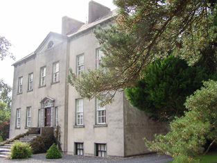
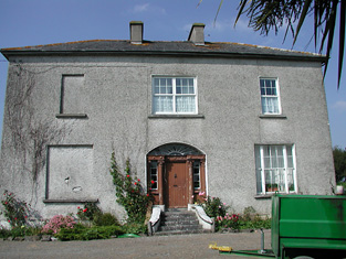
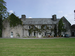
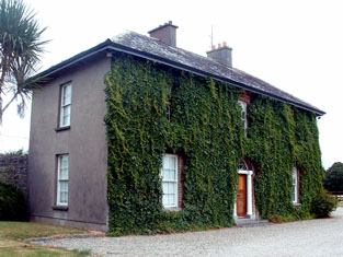
| Smithville [Yewstown House] | In 1840 the Ordnance Survey Name Books refer to Smithville "a commodious dwelling house", the residence of Mr. Boucher, though Peter Homes is mentioned as the proprietor. At the time of Griffith's Valuation, Aquilla Smith, MD, was leasing a property from the Holmes estate valued at £38. In addition Smith was leasing another property, valued at £15, to the Nenagh Poor Law Guardians, for use as an auxiliary workhouse. By the publication of the 25-inch Ordnance Survey map of the 1890s, a more substantial house at the site has become known as Yewston House. The building at the site now is known as The Manor and is in use as a nursing home. |
![Photo of Smithville [Yewstown House]](https://landedestates.ie/storage/img/orig/2843.jpg)
|
| Annebrook House | The Ordnance Survey Name Books reported in 1840 that Annebrook House was the residence of Henry Young but that P. Holmes was the proprietor. At the time of Griffith's Valuation, Henry Young was leasing the property, valued at £10+, from the Holmes estate. Buildings are still extant at the site including the remains of substanial farm buildings associated with the farm which is mentioned in the 1840s. |

|
| Butler's Lodge | In 1840 the Ordnance Survey Name Books refer to Butler's Lodge as "a gentleman's seat" in the townland of the same name. The house is labelled as Butler's Lodge on the 1st edition Ordnance Survey map but is not labelled on the 25-inch edition of the 1890s. At the time of Griffith's Valuation it was valued at over £5 and part of the estate of Edward Cambie. A modern house occupies the site now. |