Browse Houses
Search Results: Returned 5927 records. Displaying results 801 – 900
| House name | Description | |
|---|---|---|
| Beaufield House | "Bowfield" House was occupied by E. Howley in the 1830s. On both the 1st and 25-inch editions of the Ordnance Survey maps the house is labelled Beaufield House. No house of more that £1 valuation was recorded in the townland of Carrowcastle at the time of Griffith's Valuation. It is no longer extant. | |
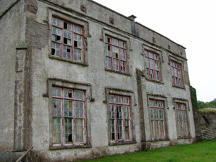
| Beaufort | Reverend Edward Day was in possession of the house at Beaufort at the time of Griffith’s Valuation when it was valued at £37. Lewis refers to it as the seat of Frederick W. Mullins in 1837. In 1814 Leet also refers to it as the residence of Reverend F. Mullins. In 1786 Wilson refers to Beaufort as the seat of Hon. Dean Crosbie. Various sources, including Bary, indicate that it was built on the site of a tower house known as Short Castle. . It was sold by the Mullins estate in the mid nineteenth century to the Day family who sold it again in the 1880s. Referred to by Slater in 1894 as the seat of Lt-Col. E. Nash Leahy. It is still extant and occupied. |

|
| Beaumont | William Wright was leasing this property from Rev. Thomas Beamish at the time of Griffith's Valuation, when it was valued at £10 10s. Built after the 1st edition Ordnance Survey map opposite the site of a diocesan school. In 1814, however, Leet noted Beaumount as the seat of William Beamish. Mrs. Susan Beamish, of Beaumont, Clonakilty, was the owner of over 1300 acres in county Cork in the 1870s. This house is no longer extant. | |
| Beaver Lodge & Carrigaline Mill | Michael Roberts was leasing this property from Michael O'Brien at the time of Griffith's Valuation. It included a mill and was valued at £100. Buildings at this site appear to have been demolished in the first decade of this century. | |
| Beckscourt House | Becks Court, located just outside the town of Bailieborough on the Young estate, was occupied by the Reverend Arnold Cosby in 1814. Lewis records the Reverend E. Mahaffy as resident. By the mid-19th century it was occupied by Sarah Mahaffy who held the property from Sir John Young of Bailieborough Castle. The buildings were valued at £12. | |
| Bedford House | Wilson refers to Bedford as the seat of Colthurst Bateman in 1786. In 1837 Lewis mentions Bedford House as the seat of S.S. Raymond.At the time of Griffith's Valuation, it was being leased by Samuel Raymond to Listowel Board of Guardians as an auxilliary workhouse and was valued at €25. Bary notes that this house was associated with the Bateman family and may have been built for the marriage of Colthurst Bateman in 1775. It is now a ruin. | |
| Beech Abbey | Originally a Begg residence, Beech Abbey in the mid 1850s was occupied by William Acheson, who was the main tenant of the Babington lands in the parish of Aughrim. The house was only valued at £2.10 shillings. It appears to have fallen into ruin by the 1890s. | |
| Beech Cottage | Eliza Lepper was leasing this property from the representatives of Robert Lepper at the time of Griffith’s Valuation, when it was valued at £13. in 1837 Lewis referred to it as the seat of Reverend A. Clements. It is no longer extant. | |
| Beech Cottage (Inishowen) | Eliza Lepper was leasing this property from the representatives of Robert Lepper at the time of Griffith’s Valuation, when it was valued at £13. It is no longer extant. | |
| Beech Cottage (Inishowen) | Eliza Lepper was leasing this property from the representatives of Robert Lepper at the time of Griffith’s Valuation, when it was valued at £13. It is no longer extant. | |
| Beech Hill | Located on the outskirts of Monaghan town, Beech Hill is named on the 1st edition 6 inch Ordnance Survey Map (1836). The buildings at Beech Hill were valued at £40 in the mid-19th century. William Murray was the occupant. He held the property from Lord Rossmore. Sarah Ker, eldest daughter of André Allen Ker, is described in Burke’s Landed Gentry of Ireland (1904) as resident here. In 1880 she married Fitzjohn Robert Irwin of Kilkeel, county Down. Beech Hill College, a secondary school, is now located on this site. | |
| Beech Hill | Beech Hill was built in the mid to late 18th century. In 1786 Wilson mentions it as the seat of Mr. Mahon. In 1814 Beech Hill was the residence of Bernard Mahon. It was offered for sale by the Mahons in 1851 and it was owned at the time of Griffith's Valuation by Edward C. Villiers and was valued at £26. In 1906 Beech Hill House was still valued at £26. It is now in ruins. |
|
| Beech Lawn (Ballymahon) | George Meares was leasing this property from the Grogan estate at the time of Griffiths Valuation, when it was valued at almost £17. A house is still extant at this site. | |
| Beech Park | An early 19th century house, the home of Marcus Keane and his family in the 19th century. Griffith's Valuation shows that he held the property from the representatives of Michael Finucane and it was valued at £20. The house was still in the possession of Marcus Keane in 1906. The house is no longer extant. | |
| Beechgrove | This house was leased by George Rutledge from Robert Fair at the time of Griffith's Valuation when it was valued at £10. Beechgrove was noted by Lewis as a residence of the Brannick family in 1837. It is still extant but unoccupied. |
|
| Beechlawn House (Kilcloony) | John Craig was leasing a house valued at £10 to Geoffrey Prendergast at Pollboy, parish of Kilcloony, at the time of Griffith's Valuation. On the 1st edition Ordnance Survey map the building at this site is labelled schoolhouse. However, a larger building of differing proportions is shown on the later 25-inch Map of the 1890s. The property at this site is named Beechlawn House by the National Inventory of Architectural Heritage. |
|
| Beechmount | Leased by John Cogan from Laurence Waldron at the time of Griffith's Valuation when it was valued at £5. Beechmount is still extant and occupied. | |
| Beechmount | Originally known as Mount Morgell and the home of the Morgell family in the 18th century. The residence of the Lloyd family in the 19th century, held in fee and valued at £32 in the 1850s. Seat of Gen.F.Lloyd in 1894. Recorded as the property of Major Langford in 1944 (ITA). Now a stud and racing stable run by the McNamara family. |

|
| Beechmount | Mary Nash was leasing this property to John Hornibrook at the time of Griffith's Valuation, when it was valued at £18. Lewis refers to it as the seat of J.Hornibrook in 1837. Still extant and now the site of Garryhankard Stud. In 2013 it was offered for sale. |

|
| Beechmount | Occupied by Dr Godfrey in 1837 and by Thomas Batten who held the property from Henry Lindsey in the early 1850s. A house is still extant at the site. | |
| Beechmount | At the time of Griffith's Valuation Sackville Hamilton occupied this house, valued at £22, which he held from James Lysaght, third son of William Lysaght of Fort William and Catherine Royse. James's son, William Lysaght, later lived in this house, which is still occupied. Sold to the Verlings in 1870. | |
| Beechmount | John Godfrey was the occupant of Beechmount, Fethard, in 1814 but by 1837 T. G. [Thomas Godfrey] Phillips was resident. He held the property from the Massys and in the early 1850s the buildings were valued at £18.12 shillings. The representatives of Samuel Phillips were still resident here in the 1870s. The house is still a residence. |
|
| Beechmount (Tramore) | In 1850 Henry Lane was leasing this property from the O'Neill-Powers when it was valued at £10. A house still exists at the site. | |
| Beechwood | A residence of the Hughes family in the 18th century. The sale rental of 1859 states that Beechwood was for many years the residence of the late Mr Ferrall. Daniel Ferrall of Beechwood was issued with a game licence in 1822. Occupied by Daniel Irwin in the 1850s when the house was valued at £40, by the Tolers in the 1880s and by Clare M. Nolan in 1906. Norton states that the Irwin brothers were nephews of Daniel Ferrall. Beechwood is no longer extant. |
|
| Beechwood Park | Beechwood, near Nenagh, was occupied by Richard C. Langford in 1814 and Lewis writes that Beechwood was the property of Colonel Toler Osborne but was occupied by D. Falkiner and had once been the residence of the Earl of Norbury. Wilson, writing in 1786, refers to "Beech Wood, the fine seat of Daniel Toler". In the mid 19th century William Osborne was resident, holding the property in fee. The buildings were valued at £33. Occupied by Lady Osborne in 1906 when the buildings were valued at £40+. The home of Philip Blake, genealogist, in the mid 20th century. This mid 18th century house still functions as a country house. |
|
| Beehive | Marked on the first edition six inch Ordnance Survey map (publ. 1837), this was a single storey house with a small plantation nearby. It was owned and occupied by Charles C.H. Coote in the mid-19th century. It may have been built for the use of an employee of the Coote family. The house and its multi-bay farm yard are still extant. |
|
| Behamore | The Reverend Thomas Hawkshaw was resident here in 1814 and Benjamin Hawkshaw in 1837. The Ordnance Survey Name Books also note it as his residence, describing Behamore as "a commodious house". James Fleetwood was the occupier in the early 1850s holding the property from Lord Dunalley, it was valued at £13+. A building is still located at this site. | |
| Bekan | The exact location of the Burke's house in the village is not known. | |
| Belclare | At the time of Griffith's Valuation all of Belclare townland was held by James Pinkerton and John Thompson who had a large milling business there, as well as three houses valued at £26, £13 and £18. The Livingstones must have bought out Pinkerton and Thompson. Belclare Lodge is marked on the OS map of 183. The Livingstone's house is shown on the 25-inch map of the 1890s, labelled Shivdella House, which is still extant. Buildings were demolished at Belclare in the late 20th century to make room for building development. |
|
| Belfort | Originally a Reeves home, occupied by them in 1837, it became the residence of the Clanchy family in the mid 19th century. John Clanchy was resident at the time of Griffith's Valuation when the house was valued at £21 and held with 37 acres from the representatives of John B. Reeves. The Irish Tourist Association Survey of the 1940s refers to it as the residence of Mrs. Clanchy, widow of J.T. Clanchy and noted that it was much associated with horseracing. Bence Jones records the demolition of this house in 1958. | |
| Belgooly Cottage | At the time of Griffith's Valuation, Belgooly Cottage was being leased to William Gash by several lessors including Mrs, Charlotte Harrison, members of the Daunt family and the Earl of Bandon's estate. It was then valued at £9. It is labelled Belgooly Cottage on the 1st edition Ordnance Survey map but is not labelled on the 25-inch edition of the 1890s. | |
| Belgrove | A house possibly inherited by the Bagwells through marriage with the Harpers. The residence of J. Travers in 1814 and of the Reverend G. Gumbleton in 1837 and in the early 1850s. The Reverend Gumbleton held the property from John Bagwell and it was valued at £36. Bence Jones writes that William Gumbleton, son of the Reverend, lived in this house under 1911. The house was demolished in the mid 20th century and a new building erected. | |
| Belhavel | Belhavel was the home of Hugh Lyons Montgomery, built during the Famine. The family took up residence there in 1850. Slater refres to it as the seat of Hugh Lyons Montgomery in 1894. The Irish Tourist Association survey in the 1940s records that "every stone was taken away to build houses throughout the district". An earlier castle also in Belhavel is reputed to have been built by the first Montgomery to settle in the area in the seventeenth century. | |
| Bella | At the time of Griffith's Valuation Arthur O'Connor was the lessor of a caretaker's house, valued at £2 10s, as well as 136 acres. Lewis recorded Bella as the residence of E. French in 1837. A ruin is still extant at the site. An entrance gateway named Flynn's Cottage is visible here now! | |
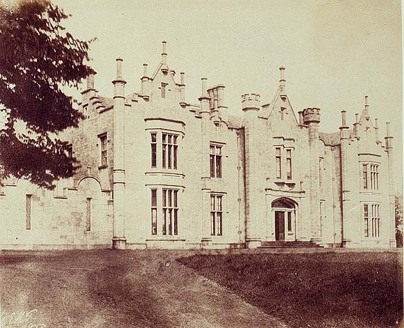
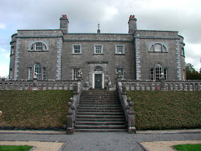
| Bellamont Forest | A red brick house, designed by Sir Edward Lovett Pearce c 1728 for Thomas Coote, younger son of Richard, Baron of Collooney. Originally known as Coote Hill but its name changed in 1767 to Bellamont Forest following Charles Coote’s elevation to the title Earl of Bellamont (2nd creation). Bellamont Forest was inherited by Charles Johnston Coote in 1800. He was one of the illegitimate children of the Earl. Bellamont Forest was occupied by Richard Coote in the mid-19th century. He held it in fee and the buildings had a rateable valuation of £50.10.0. It was sold by George Coote in 1875 to Edward Smith (K.V. Mulligan), who made a fortune out of coal. Edward Patrick Dorman Smith was the eldest son of Edward Smith and his wife Isabella Cullen and succeeded to Bellamont Forest in 1880. In 1906, Captain E. P. Smith was the occupant of the mansion house with a rateable valuation of £61.5.0. The property remained in the hands of the Smith family until the 1980s when it was purchased by an Australian, John Coote, a descendant of the former owners who spent many years renovating the house. John Coote died in 2012 and the house was sold in 2015 to an American couple. | |
| Bellamont House | Archaeological research would appear to indicate that Richard Coote had a fortified house at Collooney sometimes referred to as Bellamont House or Collooney Castle. A later structure in the town, also known as Bellamont House, is not associated with the Coote family. A possible site for Collooney Castle has been identified by Timoney drawing on earlier sources such as Terence O'Rorke. | |
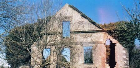
| Bellanagare Castle | Bellanagare was the home of the O'Conor family including the well-known historian Charles O'Conor. It is noted by Wilson as his seat in 1786. He later built Hermitage House some distance away and Bellanagare Castle is now in ruins. |
|
| Bellanalack | Bellanalack is marked on the first edition OS map and the later 25 inch map but a much smaller building is now located on the site. The house was occupied by Christopher Adamson in 1837 and at the time of Griffith’s Valuation (publ. 1854). He held the property valued at £13 from Lord Castlemaine. | |
| Bellavary | Charles Goodwin lived in the house in the late 1830s. The Landed Estates' Court rental records that Bellavary House was leased to Standish O'Grady McDermott by William Malley on 10 Feb 1859 for 21 years. It later became a Royal Irish Constabulary barracks and burned down in 1920. | |
| Belle Isle | A house overlooking the River Shannon, originally the home of a junior branch of the family it became the property of the 3rd Lord Avonmore through his second marriage to Cecilia O'Keeffe. The seat of 3rd Lord Avonmore in the mid 19th century held by him in fee and valued at £48. Belle Isle was occupied by Thomas Maunsell in 1814 and by Lord Avonmore in 1837. This house is no longer occupied. |

|
| Belle Lake House | In 1848 William Morris was leasing this property from Shapland C. Morris when it was valued at £24. Also noted by Shaw Mason as a seat of the Morris family | |
| Belle Vue | Belle Vue house situated in Belle Vue Park in the townland of Boytonrath was occupied by Andrew Roe in 1814 and by George Roe in 1850. The buildings were valued at £9.15 shillings. The house has been altered over the years and is still the centre of a working farm. |
|
| Belle Vue | This house is named on the 25 inch Ordnance Survey map (survey of 1908). It was built on the Shirley estate in the mid-19th century when it was occupied by John Thomas Holland and valued at £16. John Holland was appointed a magistrate by Lord Rossmore in 1854 (Dublin Evening Mail, 11 Oct 1854). Home of the Withrington in the early 20th century, now demolished. | |
| Belleek Castle/Ballina House | Edward J Howley held Belleek Castle and demesne on a lease originally granted by James O'Hara 2nd Lord Tyrawley to Vaughan Jones for 999 years, dated 25 Mar 1739. He was residing at Belleek in the 1830s. The Castle was leased to the Pery family in the late 1860s. It is now known as Ballina House. |
|
| Belleek Manor/Abbey | Built in 1831 in the Gothic style. The seat of Maj.-Gen Saunders Knox-Gire in 1894. It was sold in 1940 to the Beckett family who resold it to Mayo County Council. It became a santorium but now functions as the hotel known as Belleek Castle. |
|
| Bellefield | Bellefield was the residence of George Furnell at the time of Griffith's Valuation. He held it from William Gabbett and it was valued at £33. William's brother Daniel lived at Bellefield at one time. A Charles A. Marrett is recorded as resident at Belfield, Limerick in 1814. Belfield Park is now the location of the Regional Maternity Hospital. | |
| Belleview (Bandon) | William Seymour was leasing this property from the Earl of Shannon's estate at the time of Griffith's Valuation, when it was valued at £14. A house still exists at this site. |

|
| Belleview Cottage | Robert Whiteside was leasing the property at Lisnalurg, known as Belleview Cottage from the Wynne estate, at the time of Griffith's Valuation. It was valued at £8. The site is now occupied by a house known as Ardeevin | |
| Belleview/Bellevue | A house located on the Vandeleur estate close to the town of Kilrush, the residence of Captain Jewell in 1814 and of Nicholas S. O'Gorman at the time of Griffith's Valuation, when it was valued at £11. Weir writes that this was a late 18th century house, still extant. |
|
| Belleville | John Brennan was leasing this property from William Mayberry at the time of Griffith’s Valuation, when it was valued at £14. | |
| Belleville | Built in the late 18th and early 19th century. Belleville was held in fee by Thomas Mahon at the time of Griffith's Valuation when it was valued at £30. The only part of the house remaining is the tower. |
|
| Belleville Park (Affane) | George B. Power held Belleville Park in fee at the time of Griffith's Valuation, when it was valued at £39. Lewis noted it as the seat of S. Poer in 1837. Wilson, writing in 1786, mentions "Bettytville" as the seat of Pierce Power. The ITA survey states that it was afterwards occupied by members of the Tanner and Wyse families. At the time of the survey, in 1942, it was the home of Richard Keane, It is still extant and occupied. |
|
| Bellevue | Belview, Nenagh, was the residence of G.W. Biggs in 1814 and in 1837. The Ordnance Survey Name Books note that Thomas Sadlier was the proprietor of Bellevue inn 1840 but that it was the residence of J.W. Biggs and was " a commodious house". Samuel D. Biggs was the occupant at the time of Griffith's Valuation. He held the house valued at £30 with 315 acres from Thomas Sadlier. Samuel D. Biggs was still resident at Belview in the 1870s. Major Biggs lived at Bellevue in the 1940s. Bellevue is still extant. |
|
| Bellevue | The description in the National Inventory of Architectural Heritage records the building of this house as circa 1820 and that it was the home of the artist Douglas Alexander (1871-1945), one of three brothers who were prominent Quaker merchants in the city of Limerick. At the time of Griffith's Valuation Bellevue valued at £35 was occupied by William Alexander. Another house occupied by James Alexander and valued at £31 stood close by. Both houses were held from the Marquis of Lansdowne. Later this house was the home of the Cleeves family, toffee makers. |

|
| Bellevue | Hajba writes that William Glissan sold this property to Thomas Dennehy of Clashmore, county Waterford. Bellevue was the home of Thomas Denehy in the first half of the 19th century, inhabited by him in 1814 and 1837 and by Daniel O'Neill in the early 1850s who held it from Thomas Denehy. The house was valued at £35. Later the home of the Dunleas, now a ruin. |
|
| Bellevue (Lismore) | Paul Shewcraft was leasing this property from the Devonshire estate in 1851 when it was valued at £19 10s. | |
| Bellevue (Passage West) | In 1850, Nicholas Parker was leasing this property from the deVesci estate when it was valued at £33 10s. It is shown on the 25-inch Ordnance Survey map of the 1890s in a much enlarged form but was subsequently demolished to make way for the terrace of houses which now occupies the site. | |
| Bellevue/Lisreaghan | Belview was the main seat of the Laurence family in east Galway. Wilson, writing in 1786, refers to "Belle-view" as the seat of Mr. Lawrence "with beautiful plantations". In the 1850s it was valued at £42 and was occupied by Walter Laurence jun. In 1906 it was the property of Rev. Charles Lawrence. It is no longer extant but a famous gateway, erected in support of the Volunteers of 1782, is still visible. |
|
| Bellew's Grove | Slater refers to Bellew's Grove as a seat of Lord Grey de Ruthin in 1894. It was held by Mrs. Bellew at the time of Griffith's Valuation and valued at £30. Buildings still exist at the site. | |
| Bellfield Cottage | Bellfield Cottage, valued at £6, was the residence of Michael E. Murphy at the time of Griffith's Valuation. A house is still extant at the site. | |
| Bellgrove | The home of the Leonard family in the first half of the 19th century. The Ordnance Survey Name Books refer to Geoffrey Leonard as the proprietor in 1840 but note that the house was not inhabited. It was held by Denis Leonard in fee at the time of Griffith's Valuation when the buildings were valued at £25.10 shillings. This house was unoccupied at the time of the 1852 sale. It appears to have been bought by Hyacinth Richard Daly, who advertised it for sale again in 1863. The sale rental states that the dwelling house was in "an unfinished state". Bellgrove no longer exists. | |
| Bellgrove House | Described in the Ordnance Survey Field Name Books as a small house with a demesne of 115 acres. Occupied in 1837 by O. Irwin and the residence of John C. Davis at the time of Griffith's Valuation. Demolished in the mid 20th century. | |
| Bellmount | Bellmount, Innishannon was the residence of the Reverend James Crowley in 1814. T. Herrick was the proprietor of Bellmount in 1837 along with a large flour mill. The mill and house were in the possession of Patrick Howard at the time of Griffith's Valuation and held from John E. Herrick. The house was valued at £18 and the mill at £65. The mill building, though now disused, is still extant. |
|
| Bellmount House | Bellmount House, Curristown, is named on both the first six inch and 25 inch OS maps. It is a five-bay two-storey house, built about 1820. Although built on part of the Lyons of Ladestown estate, Bellmount House was in the possession of the Reilly family for most of the 19th century. The two families were related. In 1814 John Lyons is recorded as the occupier and in 1837 W Reilly. At the time of Griffith’s Valuation (publ. 1854) William Haig was resident holding the house valued at £36 from the representatives of Anthony A Reilly. Home of Arthur and Alice Trevor Booth in 1911. In the mid-20th century O’Brien records that Bellmount was in the ownership of the Gainsford-St Lawrence family of Howth Castle, Dublin. |
|
| Bellmount/Belmont | Bellmount or Belmont, Hallsfarm, is named on both the first edition six inch OS and the 25 inch maps. O’Brien describes it as a three-bay, two-storey house over a basement erected about 1825 by the Maguire family. In 1837 Barnard Maguire was resident. Ellen Maguire occupied the house at the time of Griffith’s Valuation (publ. 1854) when it was valued at £11.10 and held from Col William Hall. The censuses of 1901 and 1911 record Eugene Gannon, a 26 year old farmer, born in Argentina, as resident in a first class house while in 1911 Joseph Delaney, herdsman and family were in occupation. This house is still a family home. |
|
| Bellpark | Occupied by T. Robinson in 1837. The Ordnance Survey Name Books record Eyre C. Baldwin as the proprietor in 1840. It was occupied by Thomas Goold in the early 1850s. Goold held the house valued at £17+ with 116 acres from Denis Leonard and was the tenant at the time of house of the 1852 sale. A house is still extant at the site. | |
| Bellville | The Fleming family were known to be at Bellville from the early 18th century. The house is named on the first edition six inch Ordnance Survey map (publ. 1837) and located facing two forts in a sizable demesne. Belville was the home of A. Fleming in 1814 and of Captain A. Fleming in the 1830s. By the 1850s, the occupant was Jane Kenny who held the property valued at £7 from Major General Fleming. At the beginning of the 20th century Bellville was the home of the Meikle family, originally from Scotland. It is still extant. | |
| Bellwood | The Reverend Archer was living at Greenwood in 1814. Bellwood is the name given to the house marked in this townland on the first edition Ordnance Survey map. Henry Lysaght was the occupier at the time of Griffith's Valuation holding the house valued at £11+ from Sir John C. Carden. This building is still a residence. |
|
| Belmont | Home of the Blakes in the late 18th century and first half of the 19th century. Wilson refers to it as the seat of John Blake in 1786. Recorded as a steward's house at the time of Griffith's Valuation when it was held by James D. Meldon from the Bishop of Tuam. The original house is now a ruin. |
|
| Belmont | Bellmont was the residence of Thomas Grady in 1814 and of Captain Stackpoole in 1837. At the time of Griffith's Valuation it was occupied by John White who held it from Thomas William O'Grady. It was valued at £28 at this time. By the 1870s George Sampson was living at Belmount, Castleconnell. | |
| Belmont | Reverend Arthur Rowan was leasing Belmont from Arthur Chute at the time of Griffith's Valuation, when it was valued at £40. Lewis records it as the seat of Reverend A.B. Rowan in 1837. The Ordnance Survey Name Books suggest the house was built by his father in 1826 and cost £1500. However, Bary states that the house, in common with other houses in the vicinity, was built by Peter Thompson in the 1820s, when he was Treasurer of County Kerry. It is still extant and occupied. |
|
| Belmont | At the time of Griffith's Valuation Mary Anne Walsh was leasing a property valued at £17 to Hugh Byrne at Drumsna, barony of Leitrim. In June 1883 Gerald F. Walsh offered for sale the property in Drumsna known as Belmont. Modern housing now occupies the site. | |
| Belmont (Inishannon) | James Corker was leasing this property to Frederick Meade at the time of Griffith's Valuation, when it was valued at £16 10s. Lewis refers to it as the seat of Major Meade in 1837. It is still extant and occupied. |

|
| Belmont House (Ballynakill) | Sir Samuel Roberts was leasing this property from Nicholas M. Power in 1848 when it was valued at £37 6s. In 1837, Lewis noted the property as the seat of J. Roberts. | |
| Belmore Place | At the time of Griffiths Valuation in the early 1850s this property was held in fee by Robert W. Lowry, when it was valued at £16. It is labelled Belmore Place on all editions of the Ordnance Survey maps. O'Brien writes that the original house at this site had been occupied by Netterville Blake, who sold the property to Lowry in 1832. The National Inventory of Architectural Heritage suggests the surviving farm complex was built c.1850. The house was demolished in the 20th century. |
|
| Belmount (Raphoe North) | Robert Lowry was leasing this property from William Clarke's estate at the time of Grffiths Valuation in the 1850s, when it was valued at £25. The property was extant until the 1990s when modern housing was constructed on the site. | |
| Belmount House (Kilculiheen) | Held in fee by Sir Henry Barron at the time of Griffith's Valuation, when it was valued at £100. Labelled as Belmount House on the first edition Ordnance Survey map but as St. Patrick's Institution on the later 25-inch edition. Institutional buildings still exist at the site. | |
| Belrose | A house which, according to the National Inventory of Architectural Heritage, was built c.1860. The land was owned by John Hawkes at the time of Griffith's Valuation. It is still extant and occupied. |
|
| Beltany | David Wilson was leasing this property from the Ecclesiastical Commissioners estate at the time of Griffiths Valuation in the 1850s, when it was valued at £17. It is now a ruin. | |
| Beltra Rectory | This house, part of the Irwin estate, was on perpetual lease from the Cooper estate. It principally functioned as the local rectory. At the time of Griffith's Valuation the property was occupied by Rev. St.George Knox and was valued at £13. |
|
| Belvidere | This house was unoccupied in 1814. Mrs Maria Peard was the occupier in the mid 19th century holding the property from Henry Peard, it was valued at £15.12 shillings. Hajba writes that the Peards sold the estate to the Pope family who occupied the house until the early 20th century. |
|
| Belvidere/Belvedere | Belvidere is situated close to the shore of Lough Ennell with a ruined castle to the north west. It is a five-bay two-storey over basement former country house or fishing lodge built in the mid-18th century to designs by Richard Castle for Robert Rochfort, who became 1st Earl of Belvedere in 1757. Not long afterwards Rochfort made Belvedere his main home in preference to Gaulstown. Belvedere later passed on to the Marlay Family and then to Lt Col Howard-Bury. This house is very much associated with the Jealous wall, a sham folly, built to the south about 1760 to block out the view of Rochfort or Tudenham, the home of the 1st Earl’s brother George. Following the death of the 2nd Earl of Belvedere in 1814 Belvedere was inherited by his sister Jane, Countess of Lanesborough and descended to her great grandson Charles Brinsley Marlay. It was valued at £37 at the time of Griffith’s Valuation (publ. 1854) when he was resident. It’s valuation had increased to £47 by 1906. Following his death in 1912 he left Belvedere to his cousin, leader of the 1921 Mount Everest expedition Col Charles Howard Bury. When he died in 1963 he left Belvedere to a friend Rex Beaumont who sold the house in 1981 to Westmeath County Council who have restored the house and demesne in recent times. The house and gardens are open to the public and have become a major visitor attraction. |
|
| Belview House | Arthur Mahony was leasing a property valued at almost £4 from the Kenmare estate at the time of Griffith’s Valuation. In 1906 it was part of the Kenmare estate and valued at £5 5s. Bary states that this house, very close to the lake shore, was built by James Mahony, of the Dunloe Castle family, in the latter half of the 18th century. In the 1930s, it was still part of the Kenmare estate and Lord Castlerosse supervised the building of Killarney Golf Club here. The original house was demolished to make room for a new clubhouse. | |
| Belview/Bellevue | A home of the Yielding family, occupied by Richard M. Yielding in 1814 and 1837 and by Timothy Hartigan who held the property from James Barry at the time of Griffith's Valuation. The buildings were valued at £13 at that time. Bought by the Delmeges in the early 1850s. The original house is not extant. | |
| Belville | O’Brien writes that Belville was built about 1775 for Richard Cuppaidge and by the early 1780s was occupied by the Jones family. It remained the Jones family home until at least the time of Griffith’s Valuation (publ. 1854) when Gustavus Jones Junior was resident. The house was valued at £23. It is now a ruin. | |
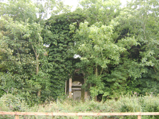
| Belville | An Orme home in the first half of the 19th century. Described in 1942 by the Irish Tourist Association surveyor as a large house near the church at Ballyglass, formerly owned by the Orme family and "purchased some years ago by Mr MacDonald, Kilfian. It has remained unoccupied...", due to a popular belief among the local people that the house was haunted. It is no longer extant. | |
| Belville (Banagh) | John Bustard held this property in fee at the time of Griffith’s Valuation, when it was valued at £13. It continued to be associated with the Bustard family throughout the nineteenth century. Though a building is shown at the site on the 1st edition Ordnance Survey map it has been substantially expanded by the publication of the 25-inch edition map and is labelled Belville. In 1906 the property here owned by George Bustard was valued at £13. It is still extant. | |
| Belville (Iveragh) | James Butler was occupying this property at the time of Griffith's Valuation, when it was valued at £9 15s. Both Lewis, in 1837, and Leet, in 1814, record it as the seat of Whitwell Butler. Bary states that it was probably built by Whitwell Butler in the late eighteenth century. In 1906 the property was owned by Arabella Butler and was valued at £8 5s. It continued to be used by the family until the end of the twentieth century but is now unoccupied and in poor repair. |

|
| Belville (Kilmacshalgan) | According to McTernan, Belville was built by Peter Rutledge on the occasion of his marriage to Catherine Ormsby in 1808. The house was occupied in the 1830s by James Rutledge. At the time of Griffith's Valuation, it was occupied by Margaret Ormsby Ruttledge, leasing from the Cooper estate and was valued at almost £4. By 1876 it was the seat of Robert McMunn who owned 582 acres in county Sligo. It was partly demolished in the twentieth century. | |
| Belville Cottage | Belville Cottage, five-bay single-storey house, built about 1820, marked on the first edition OS map and named on the 25 inch map. At the time of Griffith’s Valuation (publ. 1854) it was occupied by Florence Mahony, held from Eliza Dennis and valued at £10. |
|
| Belvoir | Belvoir was an early 19th century house on the same site as an earlier building. It was the home of the Wilson family, valued at £32 in the mid 19th century. The house was burnt in 1888 when leased by the Wilson Lynches to Lady Loftus. It was not rebuilt though recorded as the seat of Maj. Wilson Lynch in 1894. Members of the Wilson Lynch family continued to live in the remaining wing until the mid 20th century. It is now a ruin. |
|
| Belvoir (Sligo) | ||
| Belvoir (Sligo) | Wilson refers to Belvoir, situated on the other side of the Garavogue river from Hazelwood, as the seat of Mr. Ormsby in 1786. By the time of Griffith's Valuation, the property here is held by John Wynne and referred to as "a servant's house", valued at £2 15s. Buildings are still extant at the site. | |
| Benada | The Jones had a house here in the eighteenth century as Wilson refers to Banada as the seat of Mr. Jones in 1786. It was held in fee by Rev. Daniel Jones at the time of Griffith's Valuation when it was valued at £17. In 1858 it was transferred to the Sisters of Charity who ran a girls' school and orphanage there. In the twentieth century it became a secondary school and continued in that role until 2004 when it was sold to a private developer. |
|
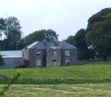
| Benison Lodge | Benison Lodge, west of Lough Lene, is named on both the first edition six inch and 25 inch OS maps. O’Brien describes it as a late 18th century, five-bay, two-storey house, probably by the O’Reilly family, one of whom was shot dead in the house in 1803 by the coachman. In 1814 Thomas H Smyth lived here and the Rev T Smyth in 1837. By the time of Griffith’s Valuation (publ. 1854) John Henry Roper was occupying the house, valued at £30 and held from William P Urquhart of Castlepollard. In the 1870s Henry J Roper of Benison Lodge owned 447 acres. In the early 20th century Richard O’Neill and family were living in a first class house in this townland. The house is now a ruin. | |
| Benlevy Lodge | A lodge situated close to the shore of Lough Mask and to the Lynch's house at Petersburg. Ocuppied by J. Blake in 1837 and by the Reverend E.G.O'Grady at the time of Griffith's Valuation. The remains of the lodge are still visible. |
|
| Benmore | In 1778 this was a Daly property and in 1786, Wilson also refers to it as the seat of Mr. Daly. In 1824 Mr. O'Connor was listed as a non-resident proprietor in county Galway. The OS Name Books record the proprietor of Benmore as Hugh O'Connor with a Mr. Dowdall acting as his agent in the 1830s. In 1855 Valentine O'Connor Blake was leasing 584 acres and buildings valued at £8 in the townland of Benmore, parish of Grange, barony of Loughrea, to Denis Deely. The original house does not appear to be extant. | |
| Bennett's Court | The Bennetts were resident at Ballymore from the 18th century but this house dates from about the 1840s. At the time of Griffith's Valuation it was the residence of Joseph H. Bennett who held it in fee. The buildings were valued at £41. Owned by a religious order in the 20th century and now in use as a medical clinic. |

|
| Bennetts Grove | Leased by Francis Bennett to William Beazley at the time of Griffith's Valuation, when it was valued at £13 10s. Lewis refers to it as the seat of Herbert Gillman in 1837. In 1814 it was the seat of Francis Bennett. The original house seems to have been replaced by farm buildings. | |
| Benvoy | Mrs. Catherine Power held Benvoy in fee at the time of Griffith's Valuation, when it was valued at £15 5s. In 1814 William Power was resident at Benvoy. There is still a house at this site. |