Browse Houses
Search Results: Returned 5927 records. Displaying results 901 – 1000
| House name | Description | |
|---|---|---|
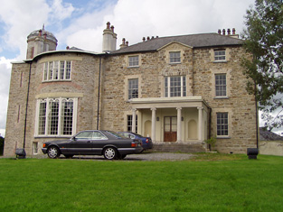
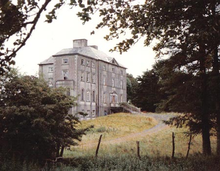
| Bermingham/Birmingham House | An 18th century house which was originally the seat of the Bermingham family, Barons Athenry and Earl of Louth. Occupied by Richard D'Arcy in 1814 and uninhabited in 1837. It was leased to John Irwin Dennis the following year and bought by him in 1851 from Clifford Trotter. Since then the house has been the home of the related families of Dennis, O'Rorke and Cusack Smith. The house and demesne were advertised for sale early in 2007. The Clonbrock Estate Papers, Collection List 54 in the National Library contain early 19th century rentals of the Bermingham estate. |
|
| Berry Hill | The National Inventory of Architectural Heritage states that this house dating from circa 1700 was a dower house for the Barrymore family of Castlelyons Castle. By the mid 19th century it was in the possession of the Perrott family and occupied by the Reverend Philip Berry who held the buildings valued at £21 with 15 acres. This house is still occupied. |
|
| Berry Hill | A house occupied by George Scott at the time of Griffith's Valuation, held from James Morrough and valued at £14. The home of Patrick Ronayne in the 1870s. This house is still a residence. |
|
| Berry Lodge | A house on the Stacpoole estate, occupied by Francis Woulf in 1814 and by a member of the O'Dwyer family in the mid 19th century. This house is still a residence. |

|
| Berrymount | Berrymount House is named on the first edition six inch Ordnance Survey map (publ. 1837). James Berry was resident in the first half of the 19th century. He held the house and outbuildings valued at £7 from the representatives of John C. Jones. William Berry of Berrymount owned 134 acres in co Cavan in 1876. The Berrys were selling Berrymount in the early 1890s (Irish Law Times and Solicitors Journal, Vol 27, 615). Alexander Morton and family were living at Berrymount in the early 20th century. The house appears to be still extant. | |
| Besborough | In the 1770s the residence of Allen Esq. The seat of the Pike family for most of the 19th century. Occupied by J. Spence in 1814 and by Ebenezer Pike in 1837 and in the early 1850s. He held the property from the representatives of Bousfield and the house was valued at £78. This house was used as a convent in the 20th century. http://www.askaboutireland.ie/reading-room/history-heritage/big-houses-of-ireland/bessborough-house-and-est/index.xml | |
| Besborough | Occupied by Reverend Theobald Butler in 1837 and still in his possession at the time of Griffith's Valuation. He held the property from Letitia Hickman and it was valued at over £22. By the 1870s this house was the home of Robert William Cary Reeves and it was still in his possession in 1906. Later in the 20th century the house became the home of the Hassett and Sexton families. | |
| Bessborough | In 1814 this house was occupied by John Mahon and in 1837 by T. Sadlier junior. The Ordnance Survey Name Books indicate that the proprietor was Mrs. Harding of Dublin and describe Bessborough as " a most beautiful house, occupied by Mr. Cushin, solicitor". By the time of Griffith's Valuation Dr John Armstrong was resident. He held the property from Mrs Harding and the buildings were valued at £20+. Jonathan Harding of Bessborough, Nenagh owned 163 acres in the 1870s. Slater refers to this house as the residence of David E. Young in 1894. It is still in use as a residence. |
|
| Bessbrook | The original house with a mill was located in the townland of Roosky. The present house in the neighbouring townland of Killygorman, is not marked on the 1st edition 6 inch Ordnance Survey Map (1836) but by about 1860 it was valued at £35, occupied by David Hamill and held from the Reverend Quinn and others. The Hamills were still resident in the early years of the 20th century. Family members were described as farmer and mill owner. | |
| Bessmount Park | The original house ‘Bessmont’, sometimes spelt Bessmount, dates from the early 1800s and is marked and named on the 1st edition 6 inch Ordnance Survey map (1836) with a walled garden to the south. It was the home of a branch of the Montgomery family and was inherited through marriage by the Nixons. In the 1830s it was the residence of A. Nixon Montgomery. In 1840 it was acquired by John Hatchell, High Sheriff of Monaghan in 1843 and his daughter held the house in fee circa 1860. The buildings were valued at £46. The house was elaborately re-modelled in an ornate style possibly to the design of an unknown architect in the late 1860s for the owner William Henderson and became known as Bessmount Park. William Henderson was married to John Hatchell’s daughter Frances Maria Isabella. Mrs Henderson, described as a widow, was living in the house in 1901 and a retired doctor Edward Taylor in 1911. This house continues to be a fine residence. |

|
| Betsborough | At the time of Griffith's Valuation, Adam Newman was leasing this property to Henry Newman, when it was valued at £19 5s. It is still extant. Family history records for the Sweetnam family indicate that Samuel Sweetnam took over Betsborough while Thomas Sweetnam was agent to the Newman estate. Henry Newman of Betsborough, Skibbereen, owned 877 acres in the 1870s. | |
| Betty Ville House | This house is marked on the first edition Ordnance Survey map. Located on the Blakiston estate, it was occupied by John Shaughnessy in the mid 19th century and held from the Messrs Young. It was valued at £5. |

|
| Bettyfield | Recorded as the seat of Sir John Conroy or O'Mulconry in the Ordnance Survey Field Name Books. Arthur O'Connor was the main tenant in the townland of Shankill at the time of Griffith's Valuation. | |
| Bettyville | Occupied by John Lee in 1814 and held by his son William Norris Lee in fee at the time of Griffith's Valuation and valued at £11+. Fitzgerald describes Bettyville in the 1820s as a 'handsome thatched cottage' occupied by Captain John Franklin. This house was the home of the Revrend John T.N. Lee and valued at £13 in 1906. | |
| Bettyville | Charles Bastable lived here in the early years of the 19th century. The house was occupied by John Therry in 1837 and in the mid 19th century, when valued at £11 and held from Anne Westropp. Bettyville was part of the Creagh estate for sale in July 1853 when it was held by the representatives of Thomas Bennett. Very little remains of this house. | |
| Bettyville | The home of the Nason family in the early 19th century, occupied by Richard Nason in 1814 and 1837. By the early 1850s William Corbin was resident holding the house valued at £14.10 shillings from the representatives of Richard Nason. William Corbin was still living at Bettyville in the 1870s. This house is no longer in existence. | |
| Bettyville | At the time of Griffith's Valuation, a house at Cloonlahan, barony of Longford, valued at £5 together with over 300 acres was held by Michael McDermott. | |
| Bewley | Captain Wiliam Chearnley was leasing this property to Geoffrey Norris at the time of Griffiths Valuation when it was valued at over £9. A farm is still extant at the site. | |
| Bilberry Hill | In 1786 Wilson writes that Bilberry Hill was the residence of the late Mr. Drury. It was the home of the Garde family in the nineteenth century, occupied in 1814 by William Garde and in the early 1850s by Winifred Garde. She held the property from Sir A. Brooke and the buildings were valued at £8.15 shilllings. The 25-inch Ordnance Survey map shows a later and larger building labelled Bilberry, which is still extant. |
|
| Bilberry Hill | William Stanford of Bilberry Hill was High Sheriff of county Cavan in 1774. This house was the home of the Irwin family from at least 1790 when Daniel Irwin of Bilberry Hill married a Miss E. Faris of Cloncorick. Leet records David Irwin as resident in 1814 and Jane Elvin [Irwin] was the occupant in the 1850s holding the property valued at £10.10.0. from Thomas Irvine [Irwin]. Jane Irwin died at Bilberry Hill in 1876 (Cavan Weekly News, 28 July 1876). The Irwins were succeeded by the Berrys of Berrymount to whom they were related. This house is no longer extant. | |
| Bilboa Court | Built in the last decade of the 17th century by the Reverend Dean Story. It was later occupied by Colonel Wilson. Lewis refers to Bilboa House as the property of the Earl of Stradbroke. It was "nearly in ruins", was built "wholly of brick from Holland" and was formerly the residence of Colonel Wilson. Circa 1840 the Ordnance Survey Name Book records a three-storey ruin with about 40 windows which had been falling into decay since about the 1770s. |
|
| Billeragh House | Robert Hilliard was leasing this property from Thomas Dennis at the time of Griffith's Valuation, when it was valued at £9 10s. Leet notes it as the residence of Mr. Hilliard in 1814. |
|
| Billis Grange | A house built after the first edition six inch Ordnance Survey map (publ. 1837) was surveyed. Mrs D. Delap was the owner and occupier in the mid-19th century when the buildings were valued at £13. There is a reference to W.C. Peyton of Billis Grange in a document in the Farnham Papers, Ms 11,499 (NLI). The building was possibly extended towards the end of the 19th century. The National Inventory of Architectural Heritage dates the present house c. 1890. The 25 inch map shows a substantial house in parkland with a lodge at the entrance gate. In 1906, Henry Sankey held over 300 untenanted acres in this locality including a building with a rateable valuation of £16.10.0. This house continues to be a family residence. |
|
| Bingarra | Occupied by James Clarke in the mid 1850s, leasing from the Bodkin estate and advertised for sale in Nov 1855. Modern buildings exist at the site now. | |
| Bingfield | A house built in the mid-18th century by the Venerable Joseph Story, Archdeacon of Kilmore. Occupied by Joseph Story in the mid-19th century, when the buildings were valued at £40. The property was held from Anthony O’Reilly. The Story family were still resident in 1901. Bingfield was sold by Arthur Patrick Story [sometime in mid-20th century, Irish Family Records (1976)]. Many of his siblings went to live in New Zealand. This house is still a fine residence. |

|
| Bingham Lodge | The main residence of this branch of the Bingham family located beside the sea. It is labelled as Bingham Lodge on the 1st edition Ordnance Survey map and a much enlarged building is thus labelled on the 25-inch map of the 1890s. It was in the possession of Henry Bingham at the time of Griffith's Valuation when it was valued at £10 10s. Remains of the walled garden can still be seen at the site. | |
| Bingham's Castle | Early 19th century building, abandoned by the Binghams circa 1925. It was held in fee by Anne Bingham at the time of Griffith's Valuation, when the buildings were valued at £20. Almost nothing remains at the site now. | |
| Binghamstown House | Built 1796 by Major Denis Bingham and let to Dean Lyons in the 1820s. At the time of Griffith's Valuation, it was valued at £13 15s and occupied by Luke Lyons. It was still owned by a descendant of the Bingham family in the mid 1990s. A house is still extant at the site. | |
| Binnion House (Inishowen) | ||
| Binnion House (Inishowen) | The Lord Bishop of Derry & Raphoe was recorded as the lessor of Binnion in the 1860s, when it was valued at £10 and occupied by Anne Lohery. It is labelled Binnion on the 1st edition Ordnance Survey map and as Binnion House on subsequent editions. A house is still extant at the site. | |
| Birch Grove | At the time of Griffith's Valuation Thomas Brabazon was leasing a property valued at £10 at Beagh, barony of Moycarn, county Roscommon, to Ellen O'Shaughnessy. In 1837 Lewis records Birch Grove as the residence of J. O'Shaughnessy. Referred to as the residence of J.J. O'Shaughnessy in 1894. A house is still extant at the site. | |
| Birchfield | Birchfield was the residence of Cornelius O'Brien in 1814 and in 1837. Lewis also refers to the erecting of an ornamental building in castellated style for the accommodation of visitors on the top of the cliffs [of Moher] by Cornelius O'Brien. The house was valued at £50 at the time of Griffith's Valuation. By the mid 1870s Birchfield belonged to Cornelius Alexander Keogh. It is now a ruin. | |
| Birchgrove | The home of the Birch family, occupied by George Birch in 1814. In 1837 Lewis writes that Birchgrove was the seat of J. Birch and that some additions were made to the house by the "late Mr Elsam". The 1835 map of Birchgrove includes a small pen and ink drawing of the house. Griffith's Valuation records George Birch as the occupier holding the house valued at £27+ and his distillery valued at £66 from the Earl of Portarlington. In 1910 Birch Grove was the home of Edward Robert Birch, eldest son of James Sayce Birch and his wife, Mary Warburton. This house on the outskirts of Roscrea is still a residence. |
|
| Birchhill Cottage/Birchhill House | This house was occupied by John Travers at the time of Griffith's Valuation. He held it from Francis Wyse and it was valued at £10.10 shillings. Jane Clerke occupied a mansion house valued at £20 in this townland in 1906. It is labelled Birchhill Cottage on the 1st edition Ordnance Survey map but as Birchhill House on the 25-edition of the 1890s. A house is still extant at the site. | |
| Bird Hill | A house located on the outskirts of Clonmel town was the residence of a member of the Taylor family in 1837. At the time of Griffith's Valuation this house valued at £10.12 shillings was occupied by Margaret Cantwell and held from Stephen Moore with 7 acres of land. This house is still in use as a residence. | |
| Birdhill | This house was originally the home of a branch of the Going family. Leet records Richard Going as the occupant in 1814. He was murdered in 1821. S. H. Atkins was resident in 1837. In 1840 the Ordnance Survvey Name Books note it as the seat of John Going and describe it as "a commodious dwelling house" with a demesne consisting of "plantation and ornamental ground". At the time of Griffith's Valuation, John Going was also the occupier when he held the house, valued at £40, with 51 acres and the national school, from Mrs Margaret Ormsby [nee Atkins]. She left Birdhill to her nephew George Twiss. Birdhill was burnt in the early 1920s and is now a ruin. | |
| Birdhill (Kyle) | Christopher Kayes held a house and offices valued at £27.18 shillings with 231 acres from Mrs Margaret Ormsby in the townland of Birdhill at the time of Griffith's Valuation. These would appear to be located south west of Birdhill House and just east of Kyle burial ground. | |
| Birdstown House | At the time of Griffiths Valuation in the 1850s Peter Maxwell was occupying Birdstown, when it was valued at £50, and leased from the Marquis of Donegall's estate. In 1837 Lewis referred to it as the seat of Reverend P.B. Maxwell. His son, Reverend Robert W. Maxwell, was the occupier in the 1870s. The National Inventory of Architectural Heritage states that the house burnt down in 1984 but stables and other estate buildings are extant. | |
| Bishop's Island | Grice Richard Smyth held buildings valued at £25 in the townland of Bishop's Island at the time of Griffith's Valuation. ''Burke's Irish Family Records'' refers to his father Henry Mitchell Smyth of Bishop's Island. In 1786 Wilson notes Bishop's Island as the seat of Mr. Mitchell. | |
| Bishopstown (Upperthird) | At the time of Griffith's Valuation, Catherine Hally was leasing this property, valued at £11, from the Trustees of Waterford College. Modern buildings exist at the site now. | |
| Blackfort | William Molloy was resident in 1814 and W. Minnett in 1837. Blackfort was advertised for sale in May 1851 by the Reverend David Fitzgerald, Edward Galwey was the petitioner. By the time of Griffith's Valuation Edward Galwey held Blackfort, or Lisduff as it became known, in fee. The buildings were valued at £15.10 shillings. Edward Galwey of Lisduff, Nenagh, owned 245 acres in county Tipperary in the 1870s. Richard Galway occupied Blackfort in 1906 when the house was valued at £22+. |
|
| Blackhorsefield | Rev. Francis Stawell was leasing this property to Eugene Sweeney at the time of Griffith's Valuation, when it was valued at £16. Changes seem to have taken place at the site by the time of the 25-inch Ordnance Survey map of the 1890s. A school occupies this location now. | |
| Blackrock | In 1906 the house at Blackrock was owned by John W.L. Birchall and was valued at £10. Arthur J.V.L.Burchall was occupying the house at the time of Griffith's Valuation when it was also valued at £10. There is still an occupied house at this site. | |
| Blackwater House | Home of the McAdam family in the 19th century before they moved to live in Sussex. The house was valued at £16 in the mid 19th century and was the residence of Philip McAdam. In 1894 Slater refers to it as the residence of Mrs. Caswell. Also known as Springhill House, it is now demolished. | |
| Blackwater Vale | This house is marked on the 1st edition 6 inch Ordnance Survey map (1836) and located just outside the town of Monaghan. The building was expanded in the mid-19th century. Griffith’s Valuation records the buildings valued at £13 when the house was occupied by Thomas E. Wright who held the property from William and Charles Crofton. At the beginning of the 20th century Blackwater Vale was occupied by Foster Dunwoody, a solicitor. Still extant and occupied. |
|
| Blair's Cove | At the time of Griffith's Valuation, this property was held in fee by Richard L. Blair and valued at £20. In 1837 Lewis had noted it as the seat of R.L. Blair. Leet refers to it as the seat of Cornelius O' Connor in 1814. It was offered for sale, as part of the Blair estate sale, in April 1866 when it was noted that "with judicious outlay in repairs it might be rendered very comfortable". The house is still extant and now houses a restaurant and luxury accommodation. See www.blairscove.ie |
|
| Blake Hill | A house on the estate of the Provost and Fellows of Trinity College, Dublin, occupied by the Blakes of Menlo in the late 18th century/early 19th century. Thomas Blake of Brendrum, county Galway, married Mary Lynch, granddaughter of Sir Roebuck Lynch Blosse, 2nd baronet, and they were the parents of the 9th and 10th Blake of Menlo baronets. By the time of Griffith's Valuation the most valuable house in the townland of Breandrim was a herd's house of £4.15 occupied by C. B. Kenny. On the 25-inch edition Ordnance Survey map of the 1890s Breandrim House is recorded as "in ruins". Old yard walls remain at this site. |
|
| Blake's Lodge | Built prior to 1838, this house may have been a sporting lodge or steward's house of the Blakes. At the time of Griffith's Valuation, the townland of over 100 acres was owned by Patrick Blake but no buildings are recorded. It is not labelled on the 25-inch Ordnance Survey map of the 1890s and Robinson writes that only the orchard walls remain. | |
| Blanket Nook | Messers Brassey and McCormack held this property in fee at the time of Griffiths Valuation in the 1850s when it was valued at £13. It is described as a steward’s house. The National Inventory of Architectural Heritage dates its building to the mid -1840s, contemporary with the massive reclamation of land from the sea which took place in the area at that time. Blanket Nook is still extant. |
|
| Blarney Castle | The original 15th century castle belonged to the McCarthys of Muskerry. In 1786 Wilson describes Blarney as the "very fine seat, with ample and beautiful demesnes, of Mr. Jeffreys". Lewis wrote in 1837 that Blarney Castle was purchased in 1701 by Sir James Jefferyes, Governor of Cork [from the Hollow Sword Blades Company] who “ soon after erected a large and handsome house in front of it, which was the family residence for many years, but is now a picturesque ruin”. A new house was built in 1874 on the demesne lands by the Colthurst family and is still occupied by them. |

|
| Blayney/Hope Castle | Originally known as Blayney Castle, this building was a late 18th century three storey five bay Georgian block in the town of Castleblayney. Lewis described it in the 1830s as ‘a handsome modern edifice, built near the site of the old castle’. It was the home of the Lords Blaney until sold in 1853 by the 12th and last Baron. Bought by Henry T. Hope and in his possession and that of his daughter’s descendants the Clintons until 1916 when it was sold. Since then the building has been a military barracks, a hospital in the 1930s and then a convent until the 1970s. In more recent times it was run as a hotel until badly damaged in an arson attack in 2010, since then it has been unoccupied. Owned by Monaghan County Council since the 1980s. |
|
| Bleach | At the time of Griffith's Valuation, Charles Graves was leasing property from the Villiers-Stuart estate which included a house and mill. The complex was valued at over £37. By the later nineteenth century Bleach House is shown here but the mill in not shown. A house is still extant at the site. | |
| Blenheim (Gaultiere) | Miss Eliza Ridgeway was leasing this property from the Beresford estate in 1848, when it was valued at £29 18s. It is still extant and occupied. |
|
| Blenheim House | At the time of Griffith's Valuation, Robert Carroll was leasing this property from Eliza Ridgeway when it was valued at £20. It is still extant and occupied. It is named as Blenheim House on both the 6-inch and 25-inch Ordnance Survey maps though it now seems to be known as Blenheim Lodge. |
|
| Blenheim Lodge | Leased by Roger Sweetman from Lord Waterford's estate at the time of Griffith's Valuation, when it was valued at £35.Lewis refers to it as the seat of Pierce Sweetman in 1837. It is still extant and operated as a guesthouse known as Blenheim House. |

|
| Blenheim Lodge | ||
| Blindwell | In 1786 Wilson refers to Blindwell as the seat of Mr. Kirwan. It was held in fee by Martin S. Kirwan at the time of Griffith's Valuation, when it was valued at almost £18. A fireplace still marks the site of the house which was demolished in the early 20th century. After 1900 this property was owned by the Websters, Nolans and now by the Fair family. Part of Blindwell also belonged to the Agricultural Institute. |
|
| Bloomfield | Johnston states that Bloomfield was once part of the Phibbs estate before passing into the ownership of the Martins of Cleaveragh. In 1814 it was occupied by William White. James Martin owned the property at the time of Griffith's Valuation when it was valued at almost £6 and leased to Joseph Robinson. It remained in the Robinson family until the twentieth century and was demolished in 1948. | |
| Bloomfield | Built circa 1776, it was the seat of the Ruttledge family. At the time of Griffith's Valuation it was held in fee by Robert Ruttledge and valued at £50. It was also the seat of Robert Ruttledge in 1894. Sold to the Land Commission in 1924 and later abandoned following a fire. |
|
| Bloomfield | Bloomfield is named on the first edition OS map, situated close to the shore of Lough Ennell, it is now a hotel and leisure centre. O’Brien writes that the house was a long low two-storey nine-bay building now greatly altered. It was most likely built by the widow of the 2nd Earl of Belvedere after her marriage to Abraham Boyd in 1815. In 1837 Lewis records the Countess of Belvedere as the proprietor. Purchased [or leased] by Col John Caulfield of Benown/Harmony Hall in 1842 from George A Boyd who had inherited it from his mother. At the time of Griffith’s Valuation (publ. 1854) Col Caulfeild was the occupant holding the house valued at £40 from George A Boyd. Purchased by Charles B Marlay later in the 19th century. Functioned as a military hospital and convent in the 20th century until it became a hotel in the 1980s. | |
| Bloomfield | In the possession of John Farrell in 1814 and of H. O'Farrell medical doctor in 1837. In the mid 19th century held by the Reverend Peter Toler in fee and valued at £10. Toler appears to have purchased Bloomfield from the sale of the Cargins Park estate by the trustees of Daniel Kelly. | |
| Bloomfield | In 1786 Wilson writes that Bloomfield Lodge was occupied by Mr. Bloomfield. In 1837 Bloomfield was occupied by Edmund Scully, fifth son of James Scully of Kilfeacle and by Edmund's son, Carbery Scully, in 1840 and at the time of Griffith's Valuation. He held the property from Lady Waller and the buildings were valued at £29. George M. Finch was living at Bloomfield, Newport in the 1870s. Bloomfield is still extant. |

|
| Blossomfort | Hajba refers to John Wrixon of Blossomfort in 1703. Wilson, writing in 1786, refers to Blossom-fort as the seat of Mr. Wrixon. The present house, occupied by William Bullen in 1814 and by J. Smith in 1837 was built by the Wrixons probably in the early 19th century. In the mid 19th century Blossomfort was the residence of Thomas Haynes who held the property from Benjamin Wrixon. It was valued at £14. Sold by the Wrixons to the Longfields of Longueville, Blossomfort became the residence of their agent, Richard Smith. This house was reconstructed following a fire in the early 1900s and is still extant. |
|
| Blossomgrove | Blossomgrove was the residence of William Casey in the early 1850s. He held the house valued at £22 and 335 acres from Simon Dring. A house is still extant at the site. | |
| Boathaven Lodge | Like Oldhead House, a summer residence, owned by the Browne family, Marquesses of Sligo, and let to various persons. At the time of Griffith's Valuation it was leased by Hugh Wilbraham and valued at £14. It is labelled Boathaven Lodge on the 1st edition Ordnance Survey map but does not appear on the 25-inch edition of the 1890s. Modern building occupy the site now. | |
| Bob's Grove/Farren Connell | The Nugent home known as Bob’s Grove dates from the mid-18th century. It was later known as Farren Connell possibly after alterations were made in the mid-19th century. In 1814, Oliver Nugent was resident at Bob’s Grove. In 1837, Lewis records Christopher E.J. Nugent as proprietor. At the time of Griffith’s Valuation Christopher’s representatives held the property in fee. It was valued at £24 for rates. Emily Nugent, a widow, was resident in 1901 and her son Colonel Oliver Nugent and his wife in 1911. Farren Connell continues to be the home of this family. |
|
| Boeeshil House | At the time of Griffith's Valuation William Shanley was leasing a property at Boeeshil, barony of Carrigallen, incuding a house and corn mill, valued at £20, from the Percy estate. There are three mills shown at the site on the 1st edition 6" OS map, including a corn, bleach and flax mill. Lewis records this property as belonging to the Gerard family. | |
| Bogay House (Raphoe North) | Reverend Edward Bowen held this property in freehold at the time of Griffith's Valuation in the 1850s when it was valued at £35. Local sources suggest it was a hunting lodge built by the Abercorn estate. It is still extant and occupied. |
|
| Bohagh Lodge | At the time of Griffith's Valuation, Robert Glancey was leasing a house valued at £6 and over 500 acres at Bohagh, barony of Castlereagh from Travers R. Blackley. | |
| Bohullion | Several properties at this location were being leased from Lord Templemore’s estate by members of the Leathem family at the time of Griffith’s Valuation, in the 1850s. Samuel Leathem senor occupied a house which was valued at £14 10s. Samuel Leathem junior occupied a house and substantial mill and distillery complex. The National Inventory of Architectural Heritage indicates that the house at the site is now called Beech Park and dates from c.1845. Elements of the industrial complex are also still extant. | |
| Bolane | Bollane Cottage was occupied by Arundel Hill in 1837. A house at Bolane was the residence of Thomas Hanly in the early 1850s and valued at £16. It was held from Daniel D. Power. A house is still extant at this location and occupied. |
|
| Bonnyglen | The Sinclair estate held two properties in fee in this townland at the time of Griffith’s Valuation. A house valued at £8 was unoccupied while a caretaker’s house was valued at almost £5. In 1906 William Montgomery Sinclair was the owner of a mansion house valued at £28 at Bonnyglen. It is no longer extant and modern houses occupy the site. In 1837 Lewis had recorded Murray Babbington as the occupier of Bonnyglen. Documents included in the Chief Secretary Office papers at the National Archives of Ireland indicate Murray Babington acted as land agent for Alexander Murray. | |
| Bookeen Glebe | Burton Persse was leasing this house to Rev. Robert Graham at the time of Griffith's Valuation. In the nineteenth century, the house was used as the residence of the incumbent at Bookeen Church. It was later purchased by the Aitken family who had served as Land Agents for the Clancarty estate at Coorheen, outside Loughrea. The house has been renovated and is extant and occupied. |

|
| Booladurragha South | William O'Neill was occupying a house in this townland at the time of Griffith's Valuation, the buildings were valued at £15+ and the property was held from the Duke of Devonshire. The Duke is given as the occupier of this house in 1906. A house still exists at this site. Boulta House now functions as a guest house. |
|
| Bopeep Lodge | A Blakeney property that was leased to H. French in the 1830s and to Robert French in the 1850s. |
|
| Boskill | Lewis records B. Friend residing at Baskill in 1837. The Ordnance Survey Field Name Book records two houses. Boskill House the original residence of the Frends dating back to the 17th century and located at the northern point of the townland. It was at the end of the 1830s a thatched house which had been converted into a stable. Boskill Lodge (marked on the first Ordnance Survey map as Boskill House) was built in 1800 by Captain Benjamin Frend, at a cost of about £600. At the time of Griffith's Valuation Benjamin Friend junior occupied this house which was valued at £18. In 1906 a mansion house in the townland of Templemichael valued at £30.15 shillings was the residence of Edith M. Minchin and Agnes E. Rose. The Frends and the Roses of Ardhu House were related. The Irish Tourist Association surveyor in 1942 records the burning of this house in the Civil War and that there was "no trace of the house now". | |
| Bosnetstown | The Bennett family were resident at Bosnetstown from the early 19th century. Charles Bennett of Bosnetstown was a coroner for county Limerick in the 1810s. Located on the estate of Lord Lisle this house was occupied by George W[heeler] Bennett in 1814 and 1837 and in the early 1850s by George Bennett. The property was valued at £14. In the 1870s George Wheeler Bennett of Kilfinane held 156 acres in the county. The Bennett also lived in other houses closeby at various times for example Kilfinane House. http://members.iinet.net.au/~nickred/trees/bennett.pdf | |
| Bouladuff | A house beside the main road from Thurles to Borrisoleigh, occupied by Thomas O'Meara and held from the Earl of Clonmel in the mid 19th century, when the buildings were valued at £12.13 shillings. The Ordnance Survey Name Books also note it as the residence of "Mr. Thomas Omar". |
|
| Bowelk | This house is not marked on the first edition 6 inch Ordnance Survey map but is recorded in Griffith’s Valuation when it was occupied by William H. Jackson, a member of a family who had extensive linen manufacturing and corn milling interests in the neighbourhood. It remained in the possession of the Jackson family until the 1920s. Advertised for sale in the Sunday Times on 5 June 2011 after renovation. |
|
| Bowen's Court | Built in the 1770s by Henry Cole Bowen this house was the seat of the Bowen family until 1959 when it was sold by the author Elizabeth Bowen. Wilson, writing in 1786, refers to it as Faraghy, the seat of Mr. Cole Bowen. It was held in fee by Mrs. Eliza Bowen at the time of Griffith's Valuation, when it was valued at £75. In 1942 the Irish Tourist Association Survey noted that the house had been attacked during the 1798 rebellion. Bowen's Court was demolished in 1961. |
|
| Boyhill House | Richard Persse was leasing a house valued at £5 from Burton Persse at Boyhill, barony of Athenry at the time of Griffith's Valuation. In 1906 it was still the property of Burton Persse who also held almost 300 acres of untenanted land in the locality. Some ruins and farm buildings still remain at the site. | |
| Boyle Grove | Boyle Grove was the residence of William Boyle in 1814 and of J. Boyle in 1837. The 1821 Census for Dromcarra records William Boyle, a gentleman farmer aged 65 and his wife Sophia, their two sons, William and James, and their daughters, see http://myhome.ispdr.net.au/~mgrogan/cork/inch_1821_cen.htm#Dromcarra By the time of Griffith's Valuation the house was occupied by Devonshire Hawkes who held it from the Court of Chancery. It was valued at £12.15 shillings. In March 1852 Boylesgrove, the estate of William Boyle, was advertised for sale. The rental records that the house was let to Devonsher P. Hawkes for 7 years in 1849 by the Court of Chancery. A house still exists at the site. | |
| Boytonrath | T. O'Meagher was the proprietor of Boytonrath in 1814. The Ordnance Survey Name Books refer to Richard Anderson as the occupant in 1840. In the early 1850s Henry Andrews was the occupier holding the property from the representatives of William Roe. The buildings were valued at £12+. A house and farm are still extant at the site. | |
| Brabazon Park | Built by George Brabazon in 1777. In 1786 Wilson refers to it as "the fine seat of George Brabazon with beautiful demesnes".Slater refers to it as the seat of George Rutledge in 1846. It was held in fee by Captain Hugh Brabazon at the time of Griffith's Valuation, when it was valued at £30. Sold by the Congested District Board to the Sisters of Mercy circa 1920s, who ran a domestic economy school there for many years. It was demolished in the later twentieth century to make way for the building of a health care facility. Part of the demesne is now Swinford Golf Course and Community Sports Facility. |
|
| Bracca Castle/Coolalough House | Coolalough House, also known as Bracca Castle, close to the village of Horseleap is named on both the first six inch and 25 inch OS maps as Coolalough. The first edition six inch map shows a castle in the townland. The estate was granted to the Handy Family in the mid-seventeenth century. Coolalough House was later a base for the Methodists in the area. Wesley records in his letters in 1785 that the Handy Family had recently built a new property at Coolalough, apparently (re)named Bracca Castle (boi). Samuel W Handy was occupying Bracca Castle in 1814 and Samuel Handy is listed as the owner of Bracca Castle in 1837. By the time of Griffith’s Valuation (publ. 1854) Joseph Hackett was occupying the house, valued at £10 and held from the representatives of Samuel W Handy. Home of Katherina Lett, a married lady, and two servants in 1911. This house is no longer extant, a green field site. |
|
| Brackernagh Lodge | A house valued at £18 at Brackernagh, parish of Kilcloony, barony of Clonmacnowen, was being leased by the Clancarty estate to Miss L. Trench at the time of Griffith's Valuation. This is most likely the house which appears on the 6-inch OS map as Brackernagh Lodge. The National Inventory of Architectural Heritage notes that it was previously known as Mount Catherine. It is still extant and occupied. |
|
| Bracklagh | The house faced Bracklagh Lough, very close to the border between counties Cavan and Longford. It is marked on the first edition six inch Ordnance Survey map (publ. 1837). In the mid-19th century it was inhabited by Captain Mark Ker and held from the Ecclesiastical Commissioners. The rateable valuation was £15. Home of Matthew William Webb and family in 1901. A building is still extant on this site. | |
| Brackley Lodge | Located very close to the shore of Brackley Lough and originally known as Brackley Lodge, the house was named on the first edition six inch Ordnance Survey map (publ. 1837). The 25 inch map of the early 20th century records its name as Brackley House. The present smaller house replaced the original building in the 1920s. Brackley was the home of John Finlay in the 1850s and in 1876. The house belonged to the Reverend John Finlay of county Carlow but was not occupied by the family at the time of the 1901 census. |
|
| Brackloon House | At the time of Griffith’s Valuation, James Hickson was leasing this house, valued at £10, to James Moriarty. On the 1st edition Ordnance Survey map this property is labelled "hotel". In 1786 Wilson refers to "Bracklow-Inn" on this road. |
|
| Bracklyn House | On the first edition OS map Bracklin House is set in an extensive demesne with gardens, plantation and outbuildings. It is a five-bay two-storey over basement neoclassical country house, built in the late 18th century by a branch of the Fetherstonhaugh family on land acquired from the Pakenham Family of Tullynally Castle, Castlepollard. Single storey wings were added in 1910. James Fetherstonhaugh was resident in 1814 and his son Thomas James in 1837. At the time of Griffith’s Valuation (publ. 1854) Anne Gavan was the occupant holding the house valued at £70 from Thomas James Fetherstonhaugh. At the beginning of the 20th century Captain Cecil Howard Digby Fetherstonhaugh and family lived at Bracklin. In 1906 the buildings were valued at £60 and held with 2,300 acres of untenanted land. O’Brien writes that in recent times Mr and Mrs Sean Murphy have restored the house. |
|
| Brade House | John Swanton was leasing this property from Rev. Maurice Townsend at the time of Griffith's Valuation, when it was valued at £15 10s. Lewis had noted it as the seat of Rev. E.P. Thompson in 1837. It was the residence of Samuel Jervois in 1814. Taylor and Skinner's 1783 map also indicate it as a Jervois residence. In 1786 Wilson refers to it as the seat of Mr.Jervis. In 1906 it was owned by Katherine Townsend and valued at £44 5s. There is still an extant house at the site. | |
| Branchfield (Duke) | At the time of Griffith's Valuation Alexander Duke was leasing property valued at £8 with almost 300 acres, at Branchfield, barony of Corran, from Jemmet Duke. Lewis records Branchfield as the seat of Rev. William Duke in 1837. Wilson notes Branchfield as the seat of Mr. Duke in 1786, remarking that the ruins of Coolteem Castle are nearby. Branchfield House has been offered for sale in recent times. |
|
| Branchfield House (Leyny) | The residence of the McKim family for many generations, Branchfield was enlarged and extended in the later nineteenth century. At the time of Griffith's Valuation it was held from Catherine Gore by Patrick McKim and valued at £5. McTernan states that the lands were sold to the Congested Districts Board in 1910, though the family retained the house. It is currently undergoing renovation. | |
| Brandon Lodge | The Ordnance Survey Field Name Books record Jane Hussey in possession of Brandon Lodge in the 1830s, describing it as a "thatched house about 40 by 20 feet on rising ground". At the time of Griffith's Valuation, Mrs. Hussey was leasing the property from Robert Hickson when it was valued at £3. The house is labelled Brandon Lodge on the 1st edition Ordnance Survey map but has disappeared by the time of the 25-inch edition in the 1890s. | |
| Brandrum | An early 18th century house located on the Cole of Florence Court estate. Early residents were Edward Mayne of the Mount Sedborough family and the Reverend Robert Montgomery, whose mother was a Cole. The house was close to another 18th century Montgomery home Ballyleck. It is named on the 1st edition 6 inch Ordnance Survey Map (1836). The Ordnance Survey Field Name Book states that ‘Brandrim is a delightful residence, there is an excellent house with good offices and gardens attached; the grounds well laid out and well planted’. Lewis records Owen Blayney Cole as the proprietor and he was leasing the property to Thomas Coote at the time of Griffith’s Valuation. The buildings were valued at £35. Brandrum was the home of Hugh Gill Patterson and family in the early 20th century. This house is now a ruin. |
|
| Brandy Hall | Daniel Leah yheld this property in fee at the time of Griffith's Valuation though it is not clear if he was occupying it. It was valued at almost £5. The National Inventory of Architectural Heritage suggests it was built c.1830 and altered in the early twentieth century. It is still extant and occupied and has been offered for sale in recent years. |
|
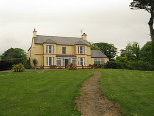
| Breaghwy Lodge | A house known as Breaghwy Lodge was the estate home of the family in the early 19th century. In 1786 Wilson refers to Breafy as the seat of Mr. Browne. This building was later replaced by a large Victorian house which was the residence of D.A Browne in 1894. It now functions as Breaffy House Hotel, |
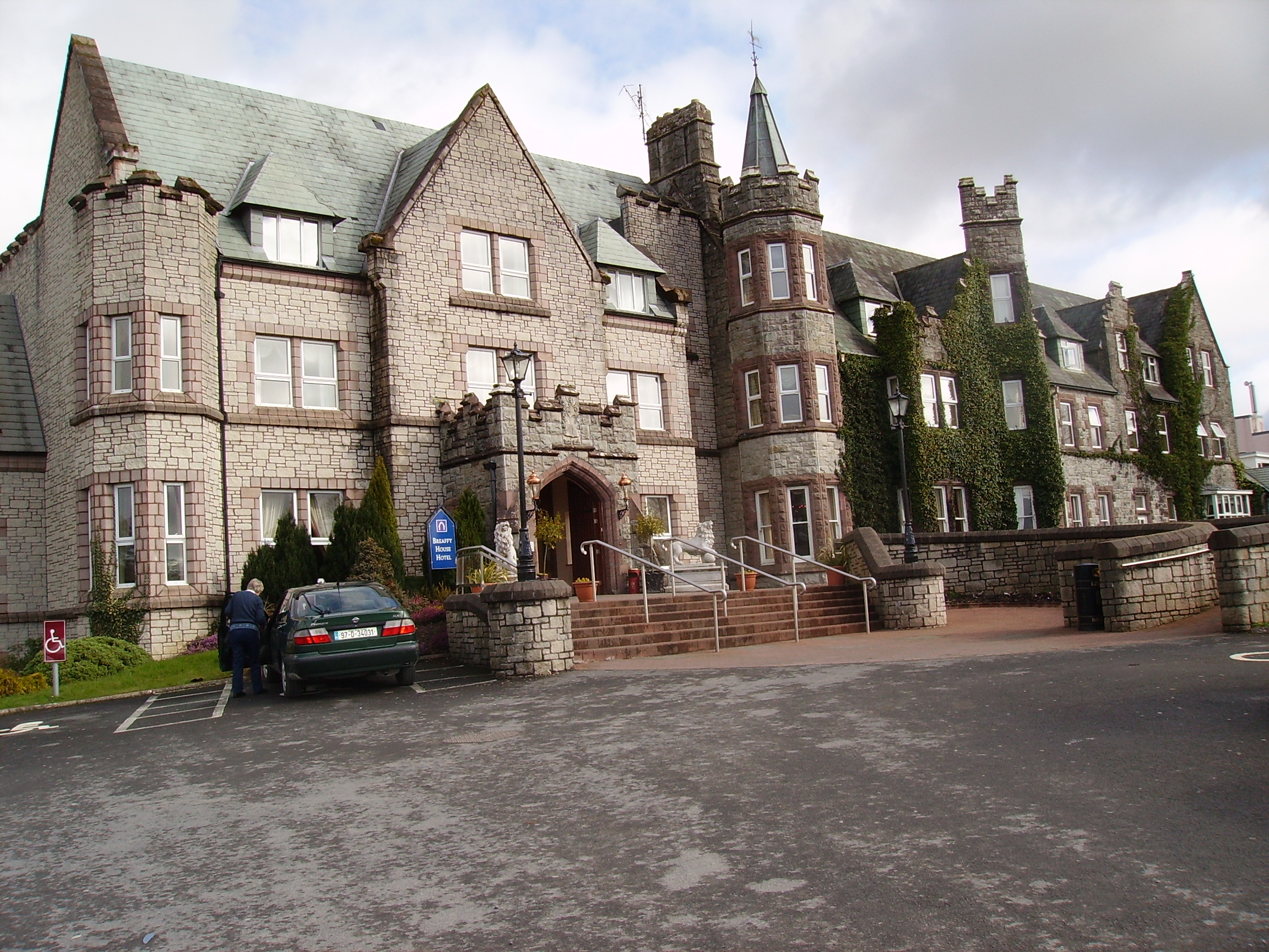
|
| Bredagh/Breda | A sale notice in the Landed Estates Court includes the house and lands at Bredagh as part of the Cruise estate. At the time of Griffith's Valuation Cruise was leasing 88 acres in this townland from Robert Ridge but there is no house on the property. | |
| Breeda House | Roger G. Davis held a house in fee, valued at £17, in this townland at the time of Griffith's Valuation. Breeda House is labelled on the 25-inch Ordnance Survey map of the 1890s. A house is still extant at the site. | |
| Breeogue | Matthew Walsh was leasing this property from the Earl of Erne's estate at the time of Griffith's Valuation when it was valued at almost £6. Breeogue House is still extant and occupied. |
|