Browse Houses
Search Results: Returned 5927 records. Displaying results 1201 – 1300
| House name | Description | |
|---|---|---|
| Cappahard House | In 1786, Wilson refers to Cappaghard as the seat of Mr. Lukey. Two houses are shown in this townland at the time of the 1st Ordnance Survey, Cappahard House and Edenview House. By the 1890s the 25-inch map shows that Edenview has become known as Cappahard House and the original house has gone. This townland was the property of Thomas Persse at the time of Griffith's Valuation and included a herd's house valued at £4. In 1901 it was occupied by the Glynn family. | |
| Cappaluane Glebe | Rev. Richard Eyre was leasing the Glebe house at Cappaluane, barony of Longford, from the Ecclesiastical Commissioners at the time of Griffith's Valuation when it was valued at £18. He was also leasing land from John Eyre. Cappaluane Glebe is still extant and occupied. In 2006 it was offered for sale. |
|
| Cappamurragh | The Grene family home occupied by John Grene in the first half of the 19th century. He held the property in fee and the buildings were valued at £24 in the early 1850s. In 1841 the Ordnance Survey Name Books describe it as "a gentleman's seat in a very handsome demesne of considerable extent". It is still extant. |

|
| Cappanihane | This house was occupied by John Mason in 1814, by R. Mason in 1837 and in use as an auxiliary workhouse at the time of Griffith's Valuation, when the buildings were valued at £15. This house was the home of John Parker Graham in the 1860s and 1870s. Another house in this townland, Glenbrook Lodge, was occupied in the early 1850s by Myles Mason and valued at £9+, grid reference R492 318. Mary Hamilton held a mansion house valued at £20 and 41 acres of untenanted land at Cappanihane in 1906. | |
| Cappard | Lewis mentions Cappard as being the seat of the Mahon family in 1837. At the time of Griffith's Valuation it was occupied by James Galbraith and was valued at £40. by 1906 it was owned by Richard Galbraith and was valued at almost £54. Cappard House is no longer extant but the remains of an extensive stable block (M514067) are still visible. |
|
| Cappercullen | Tierney writes that Lord Carbery built this house in 1717. It was inhabited by the Grady family in the latter half of the 18th century and Wilson refers to it as their seat in 1786. It was in ruins by the time of the first Ordnance Survey. The site of this house is now the tennis court at Glenstal. | |
| Cappog House | A house built in the mid-19th century, valued at £10 circa 1860 and occupied by Richard Blakely and held from Henry Mitchell. In the early 20th century home of Ernest Henry Greene, a distinguished Irish tennis player & his wife Georgiana, a painter. This house appears to be still extant. | |
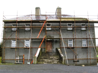
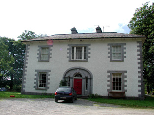
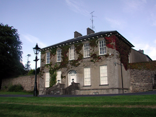
| Cappoquin House | in 1851 Cappoquin House was held in fee by Sir Richard Keane and valued at £56 15s.IN 1786, Wilson refers to the house at Cappoquin as Bellmont, the seat of John Kane. The 1855 sale notice describes it as a "handsome, modern and extensive building". In 1906 it was the residence of Lady Adelaide Keane and valued at over £57. Bence-Jones notes that it was burnt in 1923 but later rebuilt in the same style. The ITA survey in the early 1940s noted that the library and art collection were destroyed in the 1923 fire. It is still extant and occupied by the Keane family. The house and gardens are open to the public at certain times. |

|
| Capragh | A house located close to Capragh Lough was in existence at the time of the first Ordnance Survey in the 1830s. By the mid-19th century it was occupied by Hubert Kiernan who held the townland in fee. The buildings were valued at £15. Occupied by the Mitchell sisters in 1901 and by Mary Mitchell in 1911. Part of the yard buildings still remain at this site. |
|
| Caragh Lodge | Edward Denny was leasing this property to Oliver Stokes at the time of Griffith's Valuation, when it was valued at £7 15s. Bary states that the Stokes family were resident here for several generations. The original house was demolished in the early twentieth century and a new house built by Lady Gordon, a descendent of the Stokes, which was called Ard-na-Sidhe. It is now a hotel. See www.ardnasidhe.com. A Landed Estates Court sale notice dated 1873 indicates that Robert G. Ramsden had leased 70 acres from the Denny estate and built a property called Castle Carragh, originally run as a hotel, in this townland. |
|
| Carass Court | ''Burke's Irish Family Records'' states that Jeffrey Browning purchased Carass Court, from Lord Carbery. Leet records Jeffrey Browning as the proprietor of Carass Park in 1814. Jeffrey/Geoffrey Browning was married to Frances, sister of Sir David Roche, 1st Baronet. By the time of Griffith's Valuation Thomas Wise Browning was the occupier and he held the property, valued at £50, from Sir David Roche. The Brownings were still resident at Carass Court in the 1940s but the house was later demolished. |
|
| Carass House | Caherass/Carass House was the seat of the Roche family from the early 19th century. The family had a large flour mill in the townland of Caherass and the house was situated closeby but in the next townland. At the time of Griffith's Valuation Sir David Roche held the house and 235 acres in Ballouragan from Messrs Barrington and Delmege. In 1894 it was the seat of Sir David V. Roche. In 1943 the Irish Tourist Association surveyor wrote that the house was accidentally destroyed by fire "many years ago". | |
| Caraunbeg | Obadiah Holland was leasing a house valued at £8 and over 240 acres at Caraunbeg, parish of Killimordaly, barony of Kilconnell, from Lord Ashtown at the time of Griffith's Valuation. It is no longer extant. | |
| Caraunmore/Anneville | Rev. Joseph Seymour was leasing a house valued at £9 together with over 350 acres at Caraunmore, parish of Killimordaly, from the Ashtown estate at the time of Griffith's Valuation. This is possibly the house which Lewis records as Anneville, the seat of Rev. J. Seymore, in 1837. It is now a ruin. | |
| Carbery House (Dunmanway) | At the time of Griffith's Valuation, Francis Fitzmaurice was leasing two substantial houses at Sackville Street, Dunmanway, from Martha and Catherine Cox. One of these, valued at over £18, was leased to Rev Robert Molesworth, while Fitzmaurice was occupying the second, valued at over £15. In 1944 the Irish Tourist Association Survey referred to Carbery House "formerly occupied by Lord Carbery and now the residence of Mr. Smith". It is still extant. |
|
| Carewswood | Inhabited by the Dowager Countess of Shannon in 1814 and by the Reverend J. Leslie in 1837. By the time of Griffith's Valuation this house valued at £40 was in the possession of Edward Garde who held it from the Earl of Shannon. A house is still extant at the site. | |
| Careysville | Careysville Castle, originally known as Ballymacpatrick Castle, was the seat of the Carey family from the late 17th century. In 1750 Careysville was occupied by John Carey and Peter Carey was resident in 1814. In 1837 Lewis refers to “the handsome modern mansion built on the site of Careysville castle” by E.K. Carey. Valued at £50 in the mid 19th century the Careys held this property in fee. Inherited by the Montgomerys of Killee and sold by them to the Duke of Devonshire in the mid 20th century. In 1942 the Irish Tourist Association Survey noted that the house was then unoccupied as Captain Montgomery had moved into a modern bungalow nearby. Careysville is now in use as a fishing lodge offering luxury accommodation. |

|
| Cargins Park | The home of the Kelly family from the mid 18th century. Wilson refers to "Cargans, the seat of the late Daniel Kelly" in 1786. It was occupied by John D'Arcy when the estate was sold in 1852. A Victorian three bay house was the home of Daniel Kelly. Sold to Captain Drought in the mid 19th century, held by him in fee and valued at £15. The present house is not the same as Kelly's Victorian one. Renovated in the early 21st century. | |
| Carhan House | Maurice O'Connell held several properties at Carhan Lower, at the time of Griffith's Valuation, including a mill, valued at £18, which he was leasing to Patrick Trant. In the 1830s, the Ordnance Survey Name Books record that the mills had been built by Messers Trant and Barry c.1828. There were two other houses, one valued at £18, leased to James Barry, MD, and the second, valued at £6, leased to Rev. John Healy. Carhan House is named on the 1st edition OS map as "in ruins". Lewis notes "Cashen" as the old mansion of the O'Connell family in 1837. In the 1830s, the Ordnance Survey Name Books describe Carhan House as "a rectangular building, having a kitchen built up to the rere, all two stories high. The walls of its ruins are standing but in a state of dilapidation". The Irish Tourist Association Survey in 1943 described the original house as "in the shape of the letter T with the kitchen apartments nearest the river". In 1814 Leet refers to one property in Carhan as the residence of James O'Connell and to a second as the address of Miles McSweeney. |

|
| Carheen House | At the time of Griffith's Valuation Carheen was occupied by James Bourke, leasing from Peter Blake. The house was valued at £3. Carheen is still extant and in use. |
|
| Carhoo | A part of the Synge estates from the 18th century, the residence of E. Synge in 1837. The house was occupied by John Rutherford at the time of Griffith's Valuation and valued at £12. A house is still extant at the site. |
|
| Carhookeal | This house was also known as Mount Watts and Castleview. It was the home of the Williamson family for most of the 19th century. Occupied by Arthur Williamson in the early 1850s and held by him from Richard Barrett. The buildings were valued at £22. Occupied by Colonel R. F. Williamson in 1906. The Irish Tourist Association Survey in 1942 noted that it used to have a third storey and that it was then unoccupied. The National Inventory of Architectural Heritage notes its use as a GAA clubhouse in this century. |
|
| Carhoon House | Thomas Bullen was leasing Carhoon from the Devonshire estate in 1851 when it was valued at £10 10s. It is still extant and part of a large farming enterprise but not occupied. |

|
| Carhue/Carhoo | A Coppinger family home, occupied by John Rye Coppinger in 1814 and 1837 and by Henry J. Coppinger in the early 1850s. Henry J. Coppinger held the property in fee and it was valued at £18. The sale rental of 1856 states that the mansion house had recently been repaired and that Henry T. Coppinger was tenant under the Court of Chancery. A lithograph of the house and demesne is included. Burkes (1904) records George Colthurst (born 1811) of Carhue House. John Good was residing in this house in the mid 1870s. In 1894 Slater refers to it as the seat of John H. Colthurst. Carhoo House is still extant. |
|
| Carker | An early 18th century house built by the Evans family and their main residence for two centuries. It was valued at £40 in the mid 19th century and occupied by John W. Evans in 1906. The roof was removed in the 1950s but the house has been recently restored. For sale in recent years, see www.michaelhdaniels.com. |

|
| Carlanstown | At the time of Griffiths Valuation Wiilliam McCullogh was leasing this property from the Duke of Buckingham’s estate when it was valued at £13. It is located close to the site of Carlanstown Castle and labelled Carlanstown House on the 25-inch Ordnance survey map. O'Brien suggests it was built c,1830. Both he and the National Inventory of Architectural Heritage provide extensive details of its associations with older structures at the site and the connections with the Nugent family. Carlanstown is still extant and occupied. |

|
| Carn | Described in the Ordnance Survey Name Books as "a good modern slated 2 storied house". It was valued at £2.10s. at the time of Griffith's Valuation and occupied by Thomas Reilly who held it in fee. It is still extant and has been offered for sale in recent years. |
|
| Carn Cottage | Griffith’s Valuation records Captain Richard Clifford as owner and occupier and the building was valued at £28.15.0. At the beginning of the 20th century this house was the home of [retired] Lieutenant General Robert Cecil Richard Clifford, Indian Staff Corps and his wife and daughter. http://bygonedaysphotography.blogspot.ie/2016/08/two-clifford-sisters.html |
|
| Carn House | Leet records William Benison of Carn, Killeshandra, in 1814 and Lewis refers to J. Benison of Carn in 1837. The first edition six inch Ordnance Survey map (publ. 1837) shows two houses within the demesne at Carn, named Carn House and Carn Cottage. A new house on a new site is named Carn House on the 25 inch map (H296136). By the time of Griffith’s Valuation Moses Netterfield held the property valued at £15.10.0., including a house and herd’s house, from Captain Bedel Stanford. Part of the house appears to be still occupied. | |
| Carn Park | Carn Park was built by the Adamson family in the late 18th century. Travers Adamson, son of William Gustavus Adamson was resident in 1814 and W G Adamson in 1837. At the time of Griffith’s Valuation (publ. 1854) the property was in Chancery, Robert Adamson was the occupant and the buildings were valued at £24. On 17 June 1870 when the house and lands were advertised for sale in the Land Court the house was described as a ‘commodious dwelling house (with suitable out offices) on Lot 1, which, although somewhat out of repair, is capable (at a moderate outlay) of being made a comfortable residence for a gentleman and his family. The house is prettily situated on the slope of a hill, commanding an extensive view’. It was bought by the Rev Thomas Thompson Gray of Dorrington, Drumraney, who was Vice Provost of Trinity College, Dublin, 1916-1924. The house was demolished in the mid-20th century. | |
| Carnacon House | Home of the McDonnell family in the early 19th century and probably earlier as local sources suggest General James McDonnell, who fought in the 1798 Rebellion, was born there. In 1844 described by Samuel Nicholson as "neat and comfortable, prettily situated upon the lake and ornamented by thriving plantations". It was purchased by the Hughes family in the 1940s and is still in their possession. |
|
| Carnagarve House | The representatives of Reverend John G. Maddison were leasing this property from the Lyle estate at the time of Griffiths Valuation in the 1850s, when it was valued at £50. In the early 20th century it was the seat of a Major Evans. The Morgan Collection in the National Library of Ireland includes a photograph of the house taken in 1954, labelled McBrides house. Carnagarve is still extant. |
|
| Carnakelly | Carnakelly was the original house from whch the Dalys of Dunsandle descended. John Monaghan was leasing this house, valued at £4 together with over 100 acres, from Lord Dunsandle's estate, at the time of Griffith's Valuation. |
|
| Carnaleck or Carrownaleck | At the time of Griffith's Valuation John Gray was leasing a property valued at £8 together with 178 acres from Adam Mossman at Carrownaleck, barony of Leyny. This would originally have been part of the Nicholson estate. McTernan notes that the Grays surrendered their lease in the 1880s. The property is still extant and occupied. | |
| Carnaun/Carnane | Carnaun was occupied by the Kirwan family in the mid 19th century when Mary Anne Kirwan was leasing from the Ecclesiastical Commissioners. The property was valued at £12. A house is still extant at the site. | |
| Carnaveagh House | Believed to have been built by a member of the Jackson family in the latter half of the 18th century, this three storey house was sold to the Cunningham family in the early 19th century. Lewis records Joseph Cunningham as the proprietor in the 1830s. Valued at £17 in Griffith’s Valuation, it was then occupied by the representatives of Arthur Montgomery who held it from Humphrey Breakey. |

|
| Carnaveagh House | Believed to have been built by a member of the Jackson family in the latter half of the 18th century, this three storey house was sold to the Cunningham family in the early 19th century. Lewis records Joseph Cunningham as the proprietor in the 1830s. Valued at £17 in Griffith’s Valuation, it was then occupied by the representatives of Arthur Montgomery who held it from Humphrey Breakey. |
|
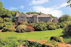
| Carnelly | An 18th century three-storey Georgian house, probably designed by Francis Bindon (1690-1765), home of the Stamer family in the 18th century and for much of the 19th century. In 1786 Wilson refer to it as the seat of William Stamer. It passed through marriage to Francis N. Burton of Carrigaholt and then to the O'Grady family. Carnelly House was let from 1840-1849 to John O’Brien of the Ballynalacken family, Member of Parliament for Limerick. His fifth son ‘Peter the Packer’, the notorious crown prosecutor, was born there in 1842. Peter O’Brien was appointed Attorney General in 1888, received a knighthood in 1891 and was created Baron Kilfenora in 1900. After 1922 distinguished historian Mr Justice Gleeson came to live at Carnelly and the Gleeson family are still resident. It was offered for sale in 2013. |

|
| Carney Castle | Daniel Grace traces the occupation of Castle Carney by members of the Grace, Chissers, Saunders, Hunt, Gamble and Nugent families. He writes that in 1797 Catherine Nugent married Arthur French, a Dublin attorney, and that their son, Arthur, came to live in his new house in the 1830s. Lewis describes Carney Castle in 1837 as the residence of A. French "a handsome modern house on part of the site of the ancient castle, now in ruins, and formerly the residence of the Grace family". At the time of Griffith's Valuation Eliza French held the house valued at £17 and 160 acres in fee. In the possession of the Walpole family in 1866. The Falkiner sale rental of June 1873 refers to the deed of partition of the lands of Carney Castle in 1862 and that the Castle Division was alloted to Mrs Eliza ffrench for life. The rental describes Mrs ffrench as "deceased" and that her interest was for sale by her four daughters. | |
| Carnisk | John Sproule was leasing this property from Sir James Stewart's estate at the time of Griffiths Valuation in the 1850s, when it was valued at £18. This appears to be the house labelled Carnisk on the 25-inch Ordnance Survey map of the early twentieth century. An earlier house, shown on the 1st edition Ordnance Survey map, was located nearby at C209209. A large farming complex exists at the Carnisk site now. | |
| Carnmore | The OS Name Books record Mr. Blake of county Mayo as the proprietor of Carnmore in the 1830s. At the time of Griffith's Valuation Valentine O'Connor Blake was leasing a house valued at £4 and over 100 acres to Arthur Veitch. Some ruins remain at the site. | |
| Carns (Kilmacteige) | At the time of Griffith's Valuation, Henry McCarrick was leasing a property valued at £14 in the village of Aclare (Carns townland), from the estate of William Evans. A shooting lodge is marked in this townland on the 25-inch Ordnance Survey map of the 1890s. | |
| Carns Lodge | In 1906 Lord Harlech's estate was the owner of buildings valued at £18 at Carns, parish of Kilmacteige. . McTernan notes the house as Carns Lodge, which he says was built in the late 1850s as a gamekeeper's house. It is still extant and occupied. | |
| Carrablagh House (Kilmacrenan) | The National Inventory of Architectural Heritage suggests that this house was built c.1850 but there is no house with a substantial valuation in this townland at the time of Griffiths Valuation. In 1906 it was owned by Henry Chichester Hart and valued at almost £11. It is still extent and in use. | |
| Carrachor | Carrachor House is named on the 1st edition 6 inch Ordnance Survey map (1836) and Lewis records J. Wright as the proprietor. It was later expanded and by the mid-19th century was held by Joseph C. Wright in fee. The buildings were valued at £16. In the early 20th century Joseph Mitchell and his wife Elizabeth were resident. Joseph Mitchell may have been a relative of the Wrights. The house is still extant. | |
| Carravilla | There are actually two houses known as Carravilla and both are marked on the Ordnance Survey map of 1838. The house located at M265 637 is named Carravilla House and is situated in a small demesne. The other, smaller, house is located at M262 641. Carravilla was occupied by Robert Fair in the 1830s. At the time of Griffith's Valuation William Ruttledge occupied Carravilla which he held from David Watson Ruttledge. Both houses are still extant. |
|
| Carrick | Carrick House located near the eastern shore of Lough Ennell, named on the first edition OS map, this is an eight-bay two-storey house, built c.1740. It is recorded on the Taylor and Skinner maps of the late 1770s and was the home of the Fetherstonhaugh family. It was the residence of William Fetherstonhaugh (died 1851) in 1837 and held by his son, another William, in fee at the time of Griffith’s Valuation (publ. 1854) when the house was valued at £29. He married Alicia daughter of Thomas Berry and they had a son Francis Berry Fetherstonhaugh who married Elizabeth Hornidge of Calverstown. Their descendants were still living at Carrick in the 1920s. |
|
| Carrick (Moville) | Miss Sydney R. Reynolds was leasing this property from the Donegall estate at the time of Griffith’s Valuation, in the 1850s, when it was valued at £10 10s. A house is still extant at this site. | |
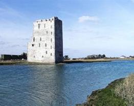
| Carrick Castle | A 16th century house built by the 10th Earl of Ormonde, which was abandoned by the family in the 18th century. Lewis wrote in 1837 “The castle is still a stately building although much of it is in ruins; it was for many years the residence of the Ormonde family, and part of it has been converted into a private residence”. At the time of Griffith's Valuation it was vacant and valued at £19. Taken over by the Office of Public Works in the 20th century and restored as a national monument. Now functions as a museum. |
|
| Carrick House | Johnston states that Carrickcoola was owned by the Ormsby Gore estate but was the residence of the McLoghrey family. McTernan indicates that the original house was of two stories but that this was later replaced by a single storey building. The Ormsby Gore estate owned 22 acres of untenanted land in Carrickcoola, barony of Tirerrill, in 1906 but the buildings are not listed. At the time of Griffith's Valuation, Maj. Ormsby Gore owned the townland and was leasing a house valued at only 10s to Thomas McCloghrey together with over 130 acres. | |
| Carrick House | The sale rental of 1851 records Walter Herbert holding the mansion house and demesne on a renewal lease dated 1796. This house no longer exists. | |
| Carrick Lodge (Banagh) | The National Inventory of Architectural Heritage suggests Carrick Lodge was built c.1867. In 1906 it was the property of Henry and Edgar Musgrave and valued at £14 15s. It is still extant. |
|
| Carrickahilla Presbytery | Rev. Michael Power, PP, was leasing this property from the Barron estate in 1851 when it was valued at £12. It is labelled Presbytery on the 25-inch Ordnance Survey map of the 1890s. There is still a house extant at this site. | |
| Carrickanna | At the time of Griffith's Valuation, Phineas Hunt was leasing this property from Robert Uniacke, when it was valued at £11. It is labelled Carrickanna on both the First and 25-inch edition Ordnance Survey Maps. The original house is no longer extant. | |
| Carrickard | At the time of Griffith's Valuation, Rev. Arthur Hyde was leasing a house at Carrickard, barony of Tirerrill from the estate of Robert Gough. The house was valued at £8. | |
| Carrickard House | At the time of Griffith's Valuation, Charles Peyton was leasing a house at Keeloges, valued at £25, from Lord Lorton's estate. |
|
| Carrickbarrahane House | James R. Smyth was leasimg this property from the trustees of Mrs. Osborne in 1851 when it was valued at £23. The National Inventory of Architectural Heritage suggests it was built c.1820. It is still extant. | |
| Carrickmore House (Furbo) | A house built on land owned by Andrew Blake at the time of Grifith's Valuation. The National Inventory of Architectural Heritage suggests it was built c.1860. It was renovated in recent times. |
|
| Carrickmoyragh House | Thomas Gregory was leasing this property from John Jessop’s estate at the time of Griffiths Valuation in the 1850s when it was valued at over £6. The National Built Heritage Service suggests that the current house was built sometime in the mid-19th century. A smaller house is shown at the site on the 1st edition Ordnance Survey map of 1838. A larger property is labelled Carrickmoyragh House on the 25-inch edition of the early 20th century. It is still extant though not in use. |
|
| Carricknagore | William Barrett was occupying Carricknagore at the time of Griffith’s Valuation. It held in fee and valued at over £13. It was occupied by his descendants into the early 20th century. A building still exists at the site. | |
| Carrickphierish A | Paul Heney was leasing this property from Waterford Corporation at the time of Griffith's Valuation when it was valued at £15 10s. | |
| Carrickphierish or Fairview | At the time of Griffith's Valuation, in 1850, this house was occupied by Owen Carroll leasing from Lawrence Roarke. The property was valued at £16. In 1881 the sale of Power property in the Land Judges Court includes a house at this location, described as "fit for the immediate reception of a gentleman's family". No longer extant. | |
| Carrig | The National Inventory of Architectural Heritage describes this as a miller's house. In 1840 The Ordnance Survey Name Books refer to it as " a good dwelling house, the residence of Christopher Dignan, there is a good flour mill close by". William Abernethy held it from the Earl of Portarlington in the mid 19th century when the house was valued at £20. It is now a ruin. James Abernethy of Carrig owned 113 acres in county Tipperary in the 1870s. |
|
| Carrig Castle | Patrick Power was leasing this property from James Mandeville at the time of Griffith's Valuation, when it was valued at £17. In 1837 Lewis refers to it as the seat of H. Power. Smith, writing in 1774, mentions it as "the house and improvements of Peter Anthony". It is not named on the later 25-inch Ordnance Survey map of the 1890s. Large farm buildings are evident at the site now. | |
| Carrig Hill | Carrig Hill is named on the first edition six inch Ordnance Survey map (publ. 1837). In the 1850s it was occupied by John Berry who held the property from Maria Finlay. In 1876 Alfred Morton of Carrigan, Ardlogher, was the owner of 50 acres. Carrig Hill was a Gilsenan home in the early 20th century and is still occupied. | |
| Carrig Park | This early 18th century house was the residence of William Causabon in 1744. By the 1770s it was the seat of a branch of the Franks family, who continued to reside there until the beginning of the 20th century. The house was held by William Hume Franks in fee at the time of Griffith's Valuation when the buildings were valued at £45 but the valuation was reduced to £35.10 shillings by 1906. The house was burnt in the early 1920s and later demolished. |

|
| Carrigacunna Castle | This house was the residence of Henry Baldwin Foote in the 19th century. Lewis writes that the estates of Monanimy, Ballygriffin & Carrigacunna formerly belonged to the ancient family of Nagle and that Carrigacunna was the residence of Sir Richard Nagle, Private Secretary to James II, who forfeited the estate in the late 17th century. In 1837 it was the property of H. B. Foott. He was the occupier in the early 1850s, the buildings were valued at £34 and the property was held in fee. Hajba writes that Henry's son George Carleton Foott lived at Carrigacunna until 1929. The Humphreys family were living here in the mid 20th century. The Irish Tourist Association Survey noted in the 1940s that Major Humphreys was residing in "a handsome modern mansions, adjoining the ruins of the old castle". The house was restored in the late 20th century. |

|
| Carrigafoyle Castle | Charles L. Sandes was leasing this property to Stephen Sandes at the time of Griffith's Valuation, when it was valued at £19 10s. It is described on the 1st edition Ordnance Survey Map as Carrigafoyle Castle but on the later 25" edition as Carrigafoyle House. In 1786 Wilson refers to it as "the ancient mansion of O'Connor Kerry, formerly a place of great strength and important.. but now serving as a store to transport goods from the adjacent places to Limerick". |
|
| Carrigaholt | Occupied by George Nolan in 1814 this house was the home of a branch of the Burton family for much of the 19th century, held in fee. Valued at £25 at the time of Griffith's Valuation, the original house no longer exists. Weir writes that a reconstructed three bay residence now occupies the site. The 16th century castle still stands in what were the demesne grounds. |

|
| Carrigaline B | Robert Atkins was leasing this property to Robert Bible at the time of Griffith's Valuation, when it was valued at £14. | |
| Carrigaline West | At the time of Griffith's Valuation, Rev. Charles McCormack was leasing this property from Michael Roberts when it was valued at £10. This may be the property which afterwards became known as Monroe House. Later in the century, Carrigaline Rectory was located in the townland of Carrigaline Middle (W730630) | |
| Carriganard | Two members of the Hartry family, William and NIcholas, were leasing houses from the Lane-Fox estate at Carriganard in 1848. William occupied the house valued at £12 7s while Nicholas held a house valued at £10 [S579089]. The original buildings do not appear to be extant now. | |
| Carriganass Castle | Held by William O'Sullivan from the Bantry estate in 1852 when it was valued at £15 10s. Lewis refers to it as the seat of W. O'Sullivan in 1837. Slater refers to it as the seat of J.E. Barrett in 1894. The house takes its name from the original O'Sullivan castle located a short distance away. | |
| Carriganear | At the time of Griffith's Valuation, John Beecher held a property at Maulbrack in fee and valued at £10 5s. This seems to be Carriganear House, mentioned by Lewis in 1837 as the residence of Mrs. Evans. There is still an extant house at the site. | |
| Carriganore House | John Strangeman was leasing this property from the Corporation of Waterford in 1850 when it was valued at £22. It now forms part of the Western Campus of Waterford Institute of Technology. |
|
| Carrigaphooca | Henry Minhear was residing in this townland at the time of Griffith's Valuation. His house was valued at £21.10 shillings and was held from Thomas Williams. This may be the house 'Yew Hill' recorded by Lewis in 1837 the residence of J. Williams. A house is still extant at this site. | |
| Carrigataha | The home of W.J. Fennel in 1837 and in 1840. The Ordnance Survey Name Books describe it as "very pleasantly situated and in good repair". It was occupied by Thomas Fennell in the early 1850s. Thomas held the property from a member of the McCarthy family and the buildings were valued at £15. Buildings are still located at this site. | |
| Carrigavulleen | Charles Knolles and William Galway were leasing this house to Bartholemew Donovan at the time of Griffith's Valuation, when it was valued at £8 5s. It is still extant and well maintained. |
|
| Carrigboy | At the time of Griffith's Valuation, Rev. Alleyn Evanson was leasing this property to John Sullivan when it was valued at almost £8. In 1906 it was owned by Hanora Harding and valued at £17 15s. | |
| Carrigboy | E. Barrett resided at Carriguoy, parish of Kilmichael, in 1837. At the time of Griffith's Valuation John E. Barrett occupied this house valued at £15.10 shillings and held by him in fee. A lithograph of the house, with the hunt assembled outside the hall door, is included in the rental. | |
| Carrigeen | John Christy held a house valued at £21 and 513 acres at Carrigeen from the Earl of Dunraven at the time of Griffith's Valuation. A modern farm is extant at the site now. | |
| Carrigeen Hall | In 1786, Wilson refers to "Carrygeen" as the seat of Mr. Peard. Hajba writes that this house was the home of Peard Harrison Peard, son of Richard Peard of Coole Abbey and father of Richard Frederick Peard of Belvidere and Henry Peard of Carrigeen. Later the home of the Green and O'Grady families, now demolished. | |
| Carrigeen House | At the time of Griffith's Valuation, Carrigeen House was leased by John Connolly from the Joyce estate when it was valued at £5. It is labelled "in ruins" on the 25-inch map of the 1890s. | |
| Carrigerry | Built in the late 18th century, this house was occupied by John O'Halloran in 1814 and by Major Creagh in 1837. Mary Creagh, who held the property from Francis Macnamara was in residence in the mid 1850s. The house is now a country hotel run by Mr and Mrs N. Ennis see http://www.carrygerryhouse.com/index.html |
|
| Carrigfadda Glebe | At the time of Griffith's Valuation, Rev. Horace Townsend was leasing this property from The O'Donovan's estate when it was valued at £12 15s. In 1837 Lewis had noted it as the seat of R.B. Townsend. It is still extant and occupied. |
|
| Carrigfadda House [Town View] | At the time of Griffith's Valuation, Phillip Sullivan was leasing this property to George Pinchin, when it was valued at £7 15s. It is named Carrigfadda House on the 6-inch Ordnance Survey map and as Town View on the 25-inch map of the 1890s. A house still exists at the site. A George Pinchin was resident at Halt House, Wiltshire in the 1850s (see Burke's Peerage) while the family also had connections with county Kerry. | |
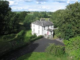
| Carrigglas Manor (Carrickglass) | The National Built Heritage Service notes that the current Carrigglas Manor was built in the mid-19th century close to the site of an earlier Carrickglass House. Leet referred to this earlier house as the seat of Sir T. Newcomen in 1814. At the time of Griffiths Valuation in the early 1850s it was leased from the Provost and fellows of TCD by Thomas Lefroy and valued at £90. The demesne remained in the Lefroy family until c.2005. The house is not currently in use. |
|
| Carriglea (Gaultiere) | Richard Phelan was leasing this property from Lord Waterford's estate at the time of Griffith's Valuation, when it was valued at £10 15s. It is no longer extant. | |
| Carriglea House | Built by John O'Dell in the early ninetenth century, in 1851 this property was held in fee by Edward O'Dell when it was valued at £59. On the 25-inch Ordnance Survey map of the 1890s it is labelled Carriglea Convent. It is still extant and a centre for care services. |
|
| Carrigmanus House | Rev. Thomas O'Grady was leasing this property to Nathaniel Lemon (?) at the time of Griffith's Valuation, when it was valued at £12. There is still a house at the site. |
|
| Carrigmoorna House | In 1851 Thomas P. Sherlock held this property from Sir Edward Kennedy's estate when it was valued at £16. On the 25-inch Ordnance Survey map of the 1890s it is named Carrigmoorna House. A modern house appears to occupy the site. |
|
| Carrigmore | Richard Power was resident here in 1814 and Edward Morragh in the mid 19th century. Morragh held the property from the Duke of Devonshire and the buildings were valued at £18+. Later the home of the Cronin family. Hajba writes that this house has been unoccupied since 1990. | |
| Carrigmore House (Kinneigh) | James Lysatt [Lysaght] held a property in fee here, valued at £46, at the time of Griffith's Valuation. Bence Jones states that it was built in 1842 by James Lysaght on the site of an earlier house known as Connorville, which had been purchased by Lysaght from the Connor family. In 1837 Lewis had referred to it as "the deserted and dilapidated mansion of the O'Connors." In 1783 Taylor and Skinner had indicated Connorsville as a seat of the Connor family as had Wilson in 1786. An adjacent smaller house, known as Laurel Hill, was held by Adderley Bernard in 1851. Carrigmore House and 312 acres, the estate of James Lysaght, were advertised for sale in July 1853. A lithograph of the house is included in the sale rental. Lyons indicates that the estate was sold privately to James L. Holmes. Carrigmore and Laurel Hill were offered for sale in the Landed Estates Court in 1876, as part of the sale of the Holmes estate. Donnelly states that it was burnt in October 1920 during the War of Independence when it was the property of James H. Morton. The house is now derelict. | |
| Carrignacurra Castle | Masters esq was the occupier of Carronacurragh or Carrignacurra in the 1770s and 1780s. Jasper Pyne is recorded as the occupier of the castle at the time of Griffith's Valuation and it was held by him in fee. The buildings were valued at £17. | |
| Carrignavar | The castle of Carrignavar was from the mid 17th century the seat of this the senior branch of the McCarthy clan. Bence Jones writes that Carrignavar is a late 19th century castellated house incorporating the remains of the old castle. Lewis refers to Carrignavar as the seat of Justic McCarthy in 1837 and Justin McCarthy junior was resident at the time of Griffith's Valuation when the buildings were valued at £28. Bought by John Sheedy in the 20th century and sold by him in the 1950s to the Sacred Heart Fathers. The house is part of their college complex. |

|
| Carrigoon | Occupied by Timothy Collins in the early 1850s and held from Joseph C. Nagle. The buildings were valued at £13. In 1942 the Irish Tourist Association survey noted its association with David Nagle who was MP for Mallow in 1689. The survey mentioned the survival at that time of the stables and coach house. A small ruined portion of this property remains, in an area where extensive quarrying has taken place. | |
| Carrigoon Cottage | A house valued at £12 and located on the Franks estate in the mid 19th century when it was occupied by William Quane and held from William H. Franks. Buildings are still extant at the site. | |
| Carrigoon House | A Stawell home in 1750 and the home of Michael Nash in the latter part of the 18th century. Occupied by James Curtin in 1814 and by William H. Franks at the time of Griffith's Valuation. It was held by Franks in fee and valued at £15. A few ruins remain of this house. | |
| Carrigoran | An 18th century house the residence of the Fitzgerald family in the 18th and 19th centuries. Griffith's Valuation shows that the house was valued at £45 in the mid 19th century and that it was held by Sir Edward Fitzgerald from Matthew Rosengrave. An earlier house reputedly destroyed by fire in the late 18th century stood nearby. The house was bought by the Sisters of Charity of the Incarnate Word in the 1920s. The house was still in use in the 1940s but was demolished in the 1980s. |
|
| Carrigrenan | Occupied by J. M. Ashlin (father of the architect George Ashlin) in 1837 and by the Reverend Robert Bury in the early 1850s. He held the house valued at £37 from Warren H. R. Jackson. The home of the Sullivans in the 20th century. |