Browse Houses
Search Results: Returned 5926 records. Displaying results 3801 – 3900
| House name | Description | |
|---|---|---|
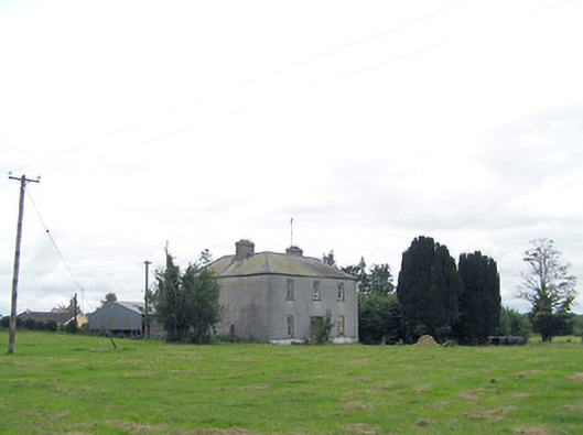
| Lisryan | James Ennis was leasing this property from the Blackall estate at the time of Griffiths Valuation in the early 1850s, when it was valued at over £20. It is not labelled on any edition of the Ordnance Survey map, though a much-expanded building is shown on the 25-inch edition. The site is now occupied by a modern house. | |
| Liss Ard | Built in the later nineteenth century Lissard was owned by The O'Donovan and valued at £90 in 1906. The Irish Tourist Association survey of 1943 mentioned that it was then the property of John Connolly. It is still extant and offered as luxury accommodation. The gardens are open to the public. See www.lissardestate.com. |
|
| Liss Cottage | James F. Bland was leasing a house valued at £5 to David Jermyn at the time of Griffith’s Valuation. This appears to be Liss Cottage, which Bary states was a residence of the Jermyn family for a long time. There is still a house at this site though it may have been altered. | |
| Lissa | Originally a Nash home, which passed to Admiral Henry Evans, a younger brother of Nicholas Green Evans, following his marriage to Elizabeth Nash in 1801. Hajba writes that it was occupied by Hugh Norcott in the early 19th century. Captain Croker was resident in 1837 and Charles Croker in the early 1850s. He held the property from the Admiral's son, Nicholas Evans, and it was valued at £32. The home of the Kerr family in the 20th century. For details of the Croker occupation see see http://members.iinet.net.au/~nickred/croker_research/The_Irish_CROKER.pdf page 65. |

|
| Lissacaha Cottage | Phillip Somerville held this property in fee at the time of Griffith's Valuation, when it was valued at £12 10s. It is labelled "Lissacaha Cottage" on the 1st edition Ordnance Map but has become "Prairie Cottage" on the later 25-inch map. In 1906 it was owned by Thomas Phillip Somerville and valued at £15 5s. It is no longer extant. | |
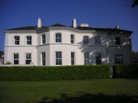
| Lissadell or Lissadill | The Gore Booth family built the first Lissadell House between 1750-1760, in front of the current house. The current house was built in the late eighteenth and early nineteenth century and continued to be the home of the Gore Booth family until the 1990s. In 1906 the house and buildings were valued at £347. The house has been open to the public for many years. It is now owned by E. Walsh and C. Cassidy and is being restored. See www.lissadellhouse.com. |
|
| Lissadorn | Lissadorn was a Crofton home from the mid 17th century. It became a Lloyd home in the 18th century following the marriage of Catherine Crofton and John Yeadon Lloyd in 1786. By 1814 Joseph Healy was living at Lisadurn. Burke's ''Landed Gentry of Ireland'' (1904) records the second son of Walter Balfe of Heathfield as John Balfe of Lissadorn. J. Balfe was residing at Lissadorn in 1837. At the time of Griffith's Valuation, Bernard Balfe held Lissadorn, valued at £20, from Viscount Lorton. It is no longer extant. On the first Ordnance Survey map (1838) the demesne included a smaller house named Ryefield. |
|
| Lissadrone | Described at the time of the first Ordnance Survey as a plain building ornamented with a few trees and shrubs and held on a lease for ever. In the 1850s it was occupied by Matthew Flynn and is now a ruin. | |
| Lissanacody | The Pollok estate held a steward and caretakers' houses at Lissanacody, barony of Longford at the time of Griffith's Valuation, valued at £6 between them. In 1906 the property was part of the estate of the John Pollok's representatives and was valued at £7.Molloy writes that these buildings, which were unoccupied at the time, were damaged by fire in 1854. Some farm buildings remain at the site. | |
| Lissanisky | The home of a branch of the Pepper family in the 19th century, occupied by Simon Pepper in 1814, by R. Smithwick in 1837. The Ordnance Survey Name Books refer to it as " a good dwelling house, the residence of Mr. Pepper". It was occupied by Theobald Pepper and Brothers in the early 1850s. This house was held from the Honourable O.F.G. Toler and was valued at £25.10 shillings. It is still extant and occupied. |
|
| Lissanode House | O'Brien writes that this house was occupied by the Russell family, probably from the early part of the eighteenth century. At the time of Griffiths Valuation, in 1854, it was occupied by Frederick W. Russell, leasing from the Boyd estate, when it had a valuation of £7. It was replaced by a more substantial house in the late nineteenth century following a fire. It is still extant. | |
| Lissanover | Members of the Hume family of Lisanober or Lissanover, Co Cavan (and of Castle Irvine, Co Fermanagh) are recorded in the 18th century, see GO MS 141: 102-104. Robert Hume of Linover died in 1777 and was buried in Templeport graveyard. In the 1830s J. Roycroft was resident at Lisnover and in the 1850s Robert Roycroft held the property from William Blachford. It was valued at £12.10.0. for rates. This house was demolished by the early 20th century. | |
| Lissanure House | Lissanure House is labelled on the 25-inch Ordnance Survey map of the early 20th century. At the time of Griffiths Valuation in the early 1850s, the property at this site was occupied by William Green, leasing from the Tuite estate, when it was valued at £4. The National Built Heritage Service suggests that the current building replaced the earlier house in the 1850s. It is still extant but not used. |
|
| Lissaquill House | In 1837 Lewis referred to Lissaquill House as the seat of Harding Fetherstone. At the time of Griffiths Valuation in 1854 this property was occupied by John Hogan, leasing from O'Brien Dillons, when it was valued at £9. The Valuation Office Books of 1841 noted the house here as having a valuation of £10 and occupied by Harding Fetherstone. A house and farm are still extant at this location. | |
| Lissard House | John L. O’Farrell was leasing this property from the Adair estate at the time of Griffiths Valuation in the 1850s, when it was valued at £35. In 1837 Lewis noted is as the O’Farrell seat also. Edward O’Farrell is noted as a property owner in Lissard in the Tithe Applotment book in 1825. Lissard survived into the twentieth century but is no longer extant. | |
| Lissardagh | The residence of William Baldwin at the time of Griffith's Valuation, held by him in fee and valued at £20. There is still a house extant at this location. |
|
| Lissava House | In 1840 the Ordnance Survey Name Books refer to Lissava House as the residence of John Egan. He was recorded among the gentry of Caher in Slater's Directory 1846. He also the occupier in the early 1850s when he was leasing it from the Earl of Glengall's estate. The buildings were valued at £12. A house is still extant at the site. | |
| Lisselane | Bence-Jones indicates that this house was built by Wiliam Bence-Jones in 1851-53. A small property, owned by the family, had existed there prior to the building of the current house. The house was sold by the Bence-Jones family in 1930. The spectacular gardens are now open to the public. In 2014 the lisselan estate was offered for sale. See www.lisselan.com. |

|
| Lisselty | At the time of Griffith's Valuation, Edmund Power was leasing this property from the Fortescue estate when it was valued over £12. Some buildings are still extant at the site. | |
| Lissenhall | In 1786 Wilson mentions Lissen-Hall as the seat of Mr. Otway. Mr Thomas Devoy occupied Lissenhall in 1814 and in 1837 Rowan P. Cashel was resident. Margaret Dagg held the house valued at £42.13 shillings from the Honourable Mrs Otway Cave at the time of Griffith's Valuation. Lissenhall dwelling house and 242 acres bought for £5000 by William H. Carrol in 1853. In 1906 the mansion house in Lissenhall townland was valued at £30 and occupied by Alice J. Carroll. This house no longer exists. | |
| Lisserlough | Lisserlough was part of the King (Viscount Lorton) estate but was let on long leases to a number of different families, notably Powell, Baker and Laurence. McTernan notes that the present house was built by Viscount Lorton in the 1850s. It is still extant and has been restored while the adjacent out-offices have been converted into apartments. | |
| Lissurland | This was an O'Brien home located on the Devon estate. Occupied by Connor O'Brien in 1814 and Henry O'Brien in the early 1850s, when the buildings were valued at £12. The house survived into the 20th century but is no longe extant. | |
| Lissycoyne | At the time of Griffith's Valuation, Patrick McDermott was leasing a property valued at £7 at Lissycoyne, barony of Tirerrill, from the Brinkley estate. It is shown as diminished in size on the 25-inch Ordnance Survey map of the 1890s. Some farm buildings are located at the site now. | |
| Lissycrimeen House | Occupied by George Travers, leasing from Jonas Travers at the time of Griffith's valuation, when it was valued at £13 10s. Some old wall boundaries are the only physical evidence at the site. | |
| Lissygreaghan | Held in fee by J. P. Gannon at the time of Griffith's Valuation when the house was valued at £4.10 shillings. | |
| Listrim House | Sir Edward Denny was leasing Listrim House to Robert Fortune at the time of Griffith's Valuation, when it was valued at £12 10s. In the 1830s the Ordnance Survey Name Books record that it was the residence of Henry Oliver by whom it was supposedly erected in 1836. It is now a ruin. | |
| Listrisnan House | This house was described as in 'good repair' at the time of the first Ordnance Survey in the 1830s. At the time of Griffith's Valuation, Joseph Jordan was leasing buildings valued at £2 in the townland of Listrisnan from Myles Jordan. A building still remains at the site. | |
| Little Island | This house was situated on an island in the Suir River in the southern part of Clonmel town. It was the home of the Morton family in the 19th century but is no longer extant. The Reverend James Morton held the house valued at £42 from his father Samuel at the time of Griffith's Valuation. | |
| Little Island Castle | At the time of Griffith's Valuation, this property was held in fee by John P. Fitzgerald, when it was valued at £25 10s. In 1837 Lewis had referred to the property as "the castle on the island owned by J. Fitzgerald". In 1906 it was the property of Gerald P. Fitzgerald and valued at £48 15s. The property remained in the Fitzgerald family until the mid twentieth century. It was turned into a luxury hotel in the 1990s. See www.waterfordcastle.com Fitzgerald was also the lessor of three other houses on the island, which were leased to members of the Grace and Power families. |
|
| Little Island House | A Bury residence, occupied by Richard Bury in 1814, by Phineas Bury in 1837 and by his widow Eliza at the time of Griffith's Valuation. The house was valued at £51 and held from the Earl of Limerick. Bence Jones wrote n 1978 that the house was a ruin and the site is now occupied by industrial buildings. | |
| Littlebridge | The Encumbered Estates Court sale notice of 1852 describes Littlebridge as "a spacious modern residence in a very handsome demesne". In the 1780s Taylor and Skinner refer to it as a seat of the Greene family. | |
| Littlebridge | In 1786, Wilson refers to Littlebridge as the seat of Andrew English. By the time of Griffith's Valuation, this area was part of the estate of Sir Richard Keane. | |
| Littlefield | Littlefield, Killenaule, was the residence of Flor Carrol in 1814 and of E. Cooke "who occasionly resides here" in 1837. Earlier, in 1786, Wilson had referred to it as the seat of Mr. Cooke. Edward Cooke is recorded as the occupier at the time of Griffith's Valuation. He held the property in fee and the buildings were valued at £12. This house is now a ruin. |
|
| Littlesilver House | Leased by Edmund B. Gash from the Devonshire estate at the time of Griffith's Valuation, when it was valued at £16. IN 1814 the residence of William Gash. A house still exists at the site. | |
| Littleton Lodge | Littleton Lodge was the residence of Thomas Ellard in 1814. In 1840 the Ordnance Survey Name Books record it as "the name of a castle, the residence of a gentleman". Charles Wilkinson as the occupier then and in the early 1850s. Wilkinson held the house valued at £17.12 shillings from Mrs Ellard. This house is still a family home. |
|
| Littletown House [Lodge] | William Magill was leasing this property from Joseph Manly at the time of Griffiths Valuation in the early 1850s when it was valued at almost £14. On the 1st edition Ordnance Survey map it appears to be located within the townland of Doonis but on the 25-inch edition of the early 20th century it seems to be within the townland of Cartroncroy. The house is labelled Littletown Lodge on the 1st edition map but as Littletown House on the 25-inch edition. It survived into the twentieth century but is no longer extant. In 1837 Lewis referred to Littleton Lodge as the seat of W. Lennox Napier. Another Littletown House is shown on the 1st edition Ordnance Survey map in the adjacent townland of Littletown [N096519] but this is described as 'in ruins' on the later map. William Magill of Littleton, Ballymahon was recorded as the owner of over 350 acres in County Longford in the 1870s. | |
| Lloydsborough | In 1786 Wilson mentions that Lloydsborough was the seat of Mr. Carden. This house was the seat of the Lloyd family in the 19th century. In 1814 Henry Lloyd was resident and in 1837 John Lloyd was the occupant. Griffith's Valuation records John as holder of the property in fee and the buildings were valued at £44+. Lloydsborough was still in the possession of a branch of the Lloyd family in the early 20th century. Still extant and occupied, Lloydsborough was offered for sale in 2014. |

|
| Lodge | An early 18th century house, originally the home of the Barry family, sold by them to Lieutenant Colonel Joseph Gabbett in 1766. Passed by inheritance from the Gabbetts to the Studderts, it was occupied by Francis Green in 1814 and by W. Studdart in 1837. The Ordnance Survey Name Books refer to it as "a commodious ancient dwelling house, the residence of William Studdert" in 1840. Maurice Studdert was the occupier at the time of Griffith's Valuation, when the house was valued at £25 and held from the representatives of General Gabbett. Maurice Studdert was the son of the Reverend George Studdert, rector of Kilpeacon, county Limerick, his wife, Mary Gabbett of High Park. Mrs Eliza Studdart of Lodge, Nenagh owned 648 acres in the 1870s. |
|
| Lodge | There is no suitable building named in this townland on the first edition of the Ordnance Survey map. A shooting lodge is, however, shown on the 25-inch Ordnance Survey map of the 1890s. This building is no longer extant. | |
| Lodge (Headford) | In 1786 Wilson refers to Lodge as the seat of Mr. Shaw. A well laid out demesne, on which there is a small building, is depicted on the 1st edition Ordnance Survey map. The townland was in the possession of the St. George estate at the time of Griffith's Valuation but the only house was valued at 15s. | |
| Lohercannon House | Catherine Day was leasing this property to Richard Murphy at the time of Griffith's Valuation when it was valued at £15. In 1786 Wilson refers to "Lower-cannon" as "formerly the seat of Rev. Mr. Day, accidentally destroyed by fire". The Ordnance Survey Name Books describe it as the seat of Edward Orpen but originally built by the Day family. Lohercannan is referred to in the Irish Tourist Association Survey of the 1940s as "another building that would be worht a visit".The second house also seems to have been held by the Days but leased out to other families including the Morrises and Eagers. It was demolished to make way for housing in the 1960s. | |
| Lohort Castle | A 15th century tower house, restored by the Perceval family, Earls of Egmont, in the mid 18th century and inhabited by their agents. At the time of Griffith's Valuation held by the Earl in fee and valued at £27. Remodelled in 1876, the castle later became the home of Sir Timothy O'Brien, baronet, and in 1906 he was recorded as the occupier. The building was burnt in July 1921 just before the War of Independence ended when it was the residence of Sir Timothy O'Brien. It was partly restored. The Irish Tourist Authority Survey reported in 1944 that it was the residence of James McCabe who had purchased it in 1925. It is still inhabited and in 2011 it was advertised for sale. |
|
| Lombardstown | The Ordnance Survey Field Name Book states that this house was rebuilt in 1823 by the occupier Thomas O'Brien. It was still occupied by Thomas O'Brien in the early 1850s. The buildings were valued at £11 and the property held from Lady Charlotte Wolfe. | |
| Lombardstown House | The seat for many years of the Lombard family, built in the mid 18th century. In 1750 Smith refers to the house as "lately built by James Lombard". From the 1830s it was leased to the Bolster family. George Bolster held the house valued at £15 plus a demesne of 101 acres from Lady Cotter in the early 1850s. The Bolsters remained in residence until the late 19th century when they sold their interest to Henry G. Smith. His descendants continue to occupy the house (Hajba). |

|
| Long Orchard | The Lalors were resident at Long Orchard from the mid 18th century. A relative, Edmund Dogherty, was the occupier in 1814. In 1837 Lewis records Richard Lalor Sheil as the proprietor. The Ordnance Survey Name Books in 1840 refer to the house as the residence of the local clergyman, Mr. Thomson. At the time of Griffith's Valuation he held the property from Richard Lalor Shiel when it was valued at £11. The Power Lalor family were still resident at Long Orchard in the early 20th century. Mrs Stella Power Lalor was the occupant in the early 1940s but the grounds and gardens had gone "wild" (Irish Tourist Association Survey).This house is now demolished. | |
| Longfield | The seat of the Long family, occupied by Richard Long in 1814 and in 1837. Bought by Charles Bianconi in the 1840s, he held it in fee in the early 1850s when the house was valued at £27+. By 1906 the house was valued at £37 and was occupied by Mary Anne O'Connell. The house remained in the ownership of Bianconi's descendants until 1968 when it was bequeathed by Mrs Mary O'Connell Bianconi to the Irish Georgian Society. |

|
| Longfield | The Sproules were settled at Longfield from the late 17th century. At the time of the first Ordnance Survey described as a house of small dimensions with ruins attached on the south side. Lewis records Longfield as the residence of P. Sproules. The house is now a ruin. |
|
| Longfield House | Occupied by Colonel Kelly in 1814 and by Mrs Kelly in the 1830s. A house valued at £4 in this townland in the 1850s was occupied by Andrew Walsh. It is now a ruin. | |
| Longfield House | Longfield House on the Marquess of Bath’s estate is marked on the 1st edition 6 inch Ordnance Survey map (1836). It was occupied at the time by the Johnston family. The Ordnance Survey Field Name Book describes the residence of W. Johnston as in the west of the townland. By the time of Griffith’s Valuation circa 1860 Thomas Johnston was resident and the buildings were valued at £30. Sidney Jackson and family were living in Longfield House at the beginning of the 20th century. This house no longer exists. | |
| Longford | The Ordnance Survey Name Books refer to Robert Lloyd as the proprietor of Longford House in the 1840s and it was occupied by him and held from Thomas Prince Lloyd at the time of Griffith's Valuation when the house was valued at £16. A mansion house in the townland of Longford valued at £34+ was occupied by James Lloyd in 1906. A building is still located at this site. | |
| Longford Glebe | Longford House is best known as the birthplace, in 1860, of the first President of Ireland, Douglas Hyde. At the time of Griffith's Valuation it was leased by Rev. John Oldfield to William Cotton and was valued at £10. It is still extant and occupied as a private dwelling. |
|
| Longford House | Longford House was built in the mid-18th century but was destroyed in a fire in the early 19th century,c1816. It is this house to which Wilson refers as the seat of Mr. Crofton in 1786. Another house was built adjacent to the original. McTernan notes that this house also suffered fire damage in both 1840 and again in 1916. At the time of Griffith's Valuation a house at Longford Demesne was valued at £13 and was the property of Sir Malby Crofton. In 1906 this was the property of Sir Malby Crofton and was valued at £30. The later Longford House is still extant and occupied. The original is an impressive ruin. |
|
| Longford House (Tirnascragh) | At the time of Griffith's Valuation, George Kenny was occupying a property valued at almost £7 at Longford. Hogan states that Longford House was built c.1844-1850. It passed from the Kenny family to Major Longbourne in the 1890s but Hogan records that he sold the estate in 1902. In 1906 the Congested Districts Board are recorded as the owners and the house was valued at £12 at the time. It passed to the Stoddart family in 1914 and is still extant and occupied. |
|
| Longford Lodge | In 1846 Slater refers to Patrick and Stephen Kelly, both of "Longford House". Patrick Kelly was occupying the house at Gortadullisk, barony of Longford at the time of Griffith's Valuation. In 1837 Lewis had recorded Longford Lodge as the home of a Major Kelly. In 1906 it was owned by Denis Kelly and was valued at almost £15. It is no longer extant though part of the walled garden remains. |
|
| Longueville House | Longueville House was the seat of the Longfield family, built in 1720. Wilson, writing in 1786, refers to it as the seat of John Longfield. In the 1850s it was valued at £56 and held by Richard Longfield from the representatives of Charles P. Coote with a demesne of 312 acres. The Longfields sold Longueville to Senator William O'Callaghan in 1938. The Irish Tourist Association survey of the 1940s claims that the original lands were taken from the O'Callaghans after the 1641 rebellion and granted to Sir Nicholas Purdon. Longueville is now a country house hotel. |

|
| Longvale | At the time of Griffiths Valuation in the 1850s Letitia Keys was leasing this property from the Knox estate when it was valued at £14. On the 1st and 25-inch edition Ordnance Survey maps it is labelled Longvale. The National Inventory of Architectural Heritage suggests that this house, now known as Hall Green Farm, mostly dates from the mid eighteenth century though possibly incorporating fabric from the earlier house on the site, reputedly built by Thomas Keyes in the early seventeenth century. |

|
| Looscaunagh | Henry Herbert was leasing a property valued at almost £4, along with over 400 acres, to Daniel McCarthy at the time of Griffith’s Valuation. It is no longer extant. | |
| Loran Park | The seat of the Roe family in the 19th century, occupied by George Roe in 1837 and in the early 1850s, when the house was valued at £25.10 shillings and held from Henry Minchin. The residence of Ellen Robinson in the mid 1870s. A house and farm are still extant at the site. | |
| Lord Brandon's Cottage | At the time of Griffith’s Valuation, Robert Chambers was leasing a property valued at almost £9 from Henry Herbert. Lewis mentions a house at this location as the seat of Rev. J. Hutchinson in 1837. This is now the site of a refreshment centre for tourists visiting the Gap of Dunloe. |

|
| Lorrha | Francis H. Toone is recorded as the occupier of a house valued at £14 and held by him in fee but it is unclear where this house was located. | |
| Loskeran House | Walter Carew was leasing this house to Thomas Clancy in 1851 when it was valued at £17. It was included in the sale of Carew's estate on 19 December 1851, in which it is described as "lately erected and occupied by Walter John Carew". The sale notice mentioned that it was occupied by the "representatives of the late Mr.Clancy". The house is not labelled on the later 25-inch Ordnance Survey Map. | |
| Losset House | This house was built in the mid-19th century on the Shirley estate, close to Lough Fea Castle. It was valued at £8 and occupied by William Roarke. |

|
| Lota House | Occupied by William Hastings Greene in 1837 [of the Greene family of Greenville, county Kilkenny] whose interest in Lota was advertised for sale in January 1851. William H. Greene was married to Mary Sarsfield of Doughcloyne and held Lota on a long lease from Robert Courtenay. George A. Wood was tenant in 1851 and resident at the time of Griffith's Valuation. He held the house valued at £85 from John Courtney. Now a hospital site. |
|
| Lota Lodge | Occupied by James H.Smith Barry in 1837 and at the time of Griffith's Valuation when the buildings were valued at £75 and held from John Courtney. The residence of Arthur Frederick Sharman Crawford at the end of the 19th century. Bence Jones writes that this house was partially destroyed by fire in 1902 and rebuilt the following year. It is now the Vienna Woods Hotel. |

|
| Lota Park | Built in the early 19th century by John Power and purchased by Jeremiah James Murphy circa 1836. By the early 1850s occupied by Colonel Ludlow Beamish who held it from John Courtney. In the 1870s the home of Edmund Burke. In the 20th century home of Joseph Gubbins and later of Mrs Francis Mahony. Now operates as a health care facility. |

|
| Lotabeg | Bence Jones writes that this house was built circa 1800 for Sir Richard Kellett 1st Baronet. Lewis gives D. Callaghan as the proprietor of Lotabeg in 1837. Poole Hickman was resident at the time of Griffith's Valuation, holding the property from William Galway. The buildings were valued at £87. Home of the Mahony family in the late 19th century. | |
| Lotamore House | The residence of the Honourable C.L. Bernard in 1837 and of Frederick Hamilton at the time of Griffith's Valuation. He held the house valued at £64 from William C. Rogers. The interest of Joseph Harrison in Lotamore was for sale in February 1871. Sir William Bartholomew Hackett was the tenant. Owned in the late 19th century by the Perrier family and the Mahonys. Wilson writing in 1786, refers to Lota as the seat of Mr. Rogers. It has operated as a guesthouse for many years. |

|
| Lough Altan Farm | The National Inventory of Architectural Heritage suggests that this property was built as a summer house by John Obins Woodhouse. At the time of Griffiths Valuation, in the 1850s, the property at the site is described as a "herd's house" with a valuation of £1 10s. It was leased from Woodhouse by Joseph Wright. It is now a ruin. |
|
| Lough Bawn | Lough Bawn House, Carrick, a two-storey, four-bay house built c 1840s as it is not marked on the first edition OS map. It was the home of the Battersby family. George Battersby held it in fee at the time of Griffith’s Valuation (publ. 1854) when the building was valued at £28.5. John Radcliff Battersby, JP and farmer, and family were resident at the beginning of the 20th century and the house remains in the possession of Battersby descendants, see https://landedfamilies.blogspot.com/2021/06/459-battersby-of-bobsville-lakefield.html |

|
| Lough Bawn House | Situated close to the shore of Lough Bawn a building at this location has been home to the Tenison family for three centuries. A family member now runs a forestry farm at Lough Bawn. Much of the original house built circa 1760 was destroyed by fire in the late 18th century. The present house dates from the early 19th century and incorporates some of the earlier building with subsequent enlargements. Lewis records the occupant as W. Tenison and Griffith’s records the house, valued at £30, as unoccupied. Still valued at £30 in 1906 when this house was occupied by Major William Tenison. |

|
| Lough Cutra (Lough Cooter) | In 1814 Loughcooter was the residence of C. Vereker, MP while Lewis records it as the seat of Viscount Gort. In the 1850s it was owned by Viscount Gough and was valued at £80. In 1906 it was still in the possession of Lord Gough when the buildings were valued at £300. Lough Cutra is still extant and occupied. A restoration programme is underway since 2000 and the castle is now available as an event location. Some of the stable yard has been converted into holiday cottages. See www.loughcutra.com. |
|
| Lough Emy | Lough Emy house on the Leslie estate was built in the mid-19th century. At the time of Griffith’s Valuation it was occupied by William V. Ryan and valued at £20. It retained this valuation in 1906. The 25 inch map (surveyed 1908) shows the house at the end of a long tree lined avenue with Emy corn mill close to the entrance. It was the home of the Kavanagh/Cavanagh family in the early decades of the 20th century. This house is completely demolished, the site is now a green area. | |
| Lough Eske | In 1837 Lewis had recorded Lough Esk as the seat of T. Brooke. At the time of Griffiths Valuation, in 1857, the buildings at Lough Eske were valued at £44 15s. Thomas Young Brooke subsequently undertook further development at the site. In 1906 the owner was Major General H.G. White and the property was valued at £90. The National Inventory of Architectural Heritage provides a detailed account of the occupation of this site from the building of a house by the Knox family in 1621. It notes that the building was run as a hotel in the early part of the 20th century until it was badly damaged by fire in 1939. It was restored in the early years of the 21st century and now functions as a luxury hotel. |
|
| Lough Fea House | Built in 1827 to the design of Thomas Rickman, this large house was the first residence of the Shirleys in county Monaghan, although they had owned a large estate since Elizabethan times. Lewis described this new edifice as ‘a spacious and handsome structure in the Elizabethan style of architecture’. A church and great hall were later additions. The buildings were valued at £180 circa 1860. The Shirley family continue to live at Lough Fea. | |
| Lough House | At the time of Griffith’s Valuation, James Hussey was leasing a property valued at £22 to Edward Hussey. Bary states that the house was built in the 1840s and that it was later used by Irish Church Missions in Dingle. In 1906 it was their property and valued at £22. It is still extant and occupied. Nearby is a tower known as Hussey's Folly, built around 1845. |
|
| Lough Hyne Cottage (Becher) | This property was held in fee as part of Sir. Henry Becher's estate at the time of Griffith's Valuation, when it was valued at £7 15s. It is described in the valuation as a "caretakers house". Labelled as "Lough Hyne Cottage" on the 1st edition Ordance Map, it is not shown on the later 25" Map. Another Lough Hyne Cottage is marked in the townland of Ballyisland on the opposite shore of Lough Hyne. On the later map this is labelled Lough Hyne House. | |
| Lough Hyne House (Cottage) | Jane Matthews was leasing this property from Lady Carbery's estate at the time of Griffith's Valuation, when it was valued at £16 5s. Lewis indicated that in 1837 it was the seat of D. McCarty. It was labelled as Lough Hyne Cottage on the 1st edition 6-inch Ordnance Map but on the later 25-inch edition is labelled Lough Hyne House. The National Inventory of Architectural Heritage suggests it was originally built as a sporting lodge. The property is still extant and used as holiday accommodation. |
|
| Lough Key House | At the time of Griffith's Valuation, Alicia Peyton was leasing a house valued at £13 at Ballykeevican, barony of Boyle, from Viscount Lorton's estate. This property is now Lough Key House guesthouse. |
|
| Lough Mask House | This house was constructed in the early 1840s when Ormsby Elwood was agent to the Earl of Erne. Robert Fair was occupying the house, valued at £10, at the time of Griffith's Valuation and would appear to have taken over as agent to Lord Erne. In the autumn of 1880 Lough Mask House was the scene of the first boycotting incident when Charles Boycott was the agent for the estate. By the mid 1880s Bernard Daly had bought Boycott's lease of the house and farm and his descendants continue to live at Lough Mask. |
|
| Lough Ree Lodge | This lodge located on the eastern shore of Lough Ree, named on the first edition OS map, is a four-bay two-storey house, built c.1815, by a branch of the Handcock-Temple family of Waterstown House. It was the home of a Gustavus H. Temple, in 1837 and at the time of Griffith’s Valuation, when it was valued at £21. Later the home of the Daniels and Fagan families and still occupied. |
|
| Lough Rynn | Lough Rynn was built in the early 1830s by Robert, Viscount Clements, heir to the 2nd Earl. At the time of Griffith's Valuation it was valued at £40. In 1906 it is recorded as the property of Col. H.T. Clements and has a valuation of £100. It is still extant. In 2006 it opened as a luxury hotel. For more information see www.loughrynn.ie and www.loughrynn.net. |
|
| Lough Veagh House (Belleville) | At the time of Griffiths Valuation in the 1850s, this house was held in fee by John Stewart, when it was valued at £27. Documents in Donegal County Archives indicate it was conveyed to Stewart by Daniel and Elizabeth Chambers in 1845. In 1837 Lewis had referred to "Gartan" as the seat of Captain Chambers. By 1906 it was owned by Edward D. Hewetson and still valued at £27. The house is no longer extant and the site is now occupied by Gartan Outdoor Centre. | |
| Loughananna | At the time of Griffith's Valuation a house at Loughananna was occupied by James McGrath, valued at £10+ and situated on the Kingston estate. By 1906 the mansion house at Loughananna was valued at £50+ and Abel Buckley is recorded as the occupier. | |
| Loughatalia | A house valued at £20 was occupied by William Humphreys at Loughatalia in the mid 19th century. He held the property with 34 acres from Henry Garde. This house now functions as a guest house known as Lochcarrig. |
|
| Loughburke | This house was originally the home of a branch of the Burke family. In the late 18th century it passed into the possession of the Lucas family who continued to reside there until the mid 19th century. C. and B. Lucas were in occupation in 1814 and Lewis records Lough Burke as the ancient seat of the Burke family ''now occupied by the Lucas family''. At the time of Griffith's Valuation the house was valued at £1 and James Casey was the tenant holding from the Woodwards. | |
| Loughderry | Located close to the shore of Lough Derry this house was the residence of S. Pendleton in the 1830s. The house may have been extended by the time of Griffith’s Valuation circa 1860 when it was valued at £17. It was occupied by George Renwick [Rennick] who held the property from William Brownlow. Family sources suggest George Rennick was formerly the proprietor of the Shirley Arms Hotel in Carrickmacross and the King's Arms in Clones, before retiring to Derry sometime between 1846-1860. Loughderry House has been the home of the Rennick family for many generations. | |
| Loughglynn | Loughglynn was the main residence of the Dillon family, built circa 1715, extended in the 1820s and altered again in the early 20th century. It is recorded in 1814, 1837 and in Griffith's Valuation as the seat of Viscount Dillon. The Dillons were absentee landlords for much of the nineteenth century and their agents, the Stricklands, lived in the house. During the twentieth century the house served as a convent. Loughglinn House is still extant. |
|
| Loughgur Castle | In 1786 Wilson refers to Lough-Gur as the seat of Henry Baylee. This house was ccupied by John "Boylie" in 1814 and by Miss Bailie in 1837. In the early 1850s William Evans was resident. He held the house valued at £11 from the Count De Salis. It was adjacent to the remains of a tower house known as Bouchier's Castle. The property at this site is labelled "Lough Gur Farm" on the 25-inch map of the 1890s. The book edited by Mary Carbery, "The Farm by Lough Gur", published in 1937, contains a description of the Baylee property at Loughgur. The original Bayley house is no longer extant. | |
| Loughkeen Glebe | In 1840 the Ordnance Survey Name Books describe the Glebe at Loughkeen as "a good dwelling house the residence of Rector Synge". At the time of Griffith's Valuation, it was leased by Reverend Francis Synge from the Ecclesiastical Commissioners and valued at £23+. It is still extant and occupied. |
|
| Loughkent | Nicholas Dogherty is recorded as the occupier of Loughkent House in 1814 and in 1850, when he held the house valued at £12.18 shillings from Arthur Riall. It is no longer extant. | |
| Loughlohery | In 1786 Wilson refers to "Loughlokery" as the seat of Mr. Dogherty. The residence of William Quin from at least 1814 and held by him in fee in the early 1850s when the house was valued at £33. The Quinns were still resident at Loughloher in the 1870s. A house is still extant at the site. | |
| Loughoony | An elongated building facing the lake of the same name and marked on the 1st edition Ordnance Survey map (1836). The National Inventory of Architectural Heritage dates this house to circa 1790 and describes it as having a multiple-bay two-storey return. The Ordnance Survey Field Name Book records it as a good dwelling house the residence of Mrs Murray, widow of a Counsellor who was drowned in the lake nearby. In the mid-19th century the buildings were valued at £20 and the house was inhabited by Andrew Clarke who held it from William Ritchie. Loughoony was the home of Samuel Condell and family at the beginning of the 20th century |
|
| Loughpark | Lough Park House, situated on the shores of Lough Lene to the south east of Castlepollard, this five-bay two-storey house, built about 1790 was home to the Evans family for much of the 19th century. N Evans was resident in 1837 and Michael Evans at the time of Griffith’s Valuation (publ. 1854). He held the house valued at £20 from William P Urquhart of Castlepollard. Thomas Pender, farmer and family lived here in 1901 and Samuel R Sutton, farmer and family in 1911. The property remains a family home. |
|
| Loughscur | Loughscur was originally a seat of the Reynolds family but later passed into the ownership of the Peyton family through marriage. In 1894 Slater refers to it as the seat of James Reynolds Peyton. However, this may refer instead to the Peyton property at Laheen. | |
| Lowberry | The Encumbered Estates' Sale notice of May 1856 indicates that the mansion at Lowberry had "formerly" stood in the demesne and recommends it as a "most desirable site for building". It is shown on the First Edition Ordnance Survey map but no buildings are recorded in the townland at the time of Griffith's Valuation. It is labelled "Lowberry House (in ruins)" on the 25-inch map of the 1890s. A portion of these ruins still remain at the site. | |
| Lower Shannon House | John Duncan was leasing this property from the Wynne estate at the time of Griffith's Valuation, when it was valued at £10.McTernan notes that it was purchased by his relatives from the Wynne estate in the early twentieth century. The property was sold again in the 1920s to the Donaghy family and continues in their possession. | |
| Lower Tawnies Cottage | Rev. Henry Stewart was leasing this property from the Earl of Shannon's estate at the time of Griffith's Valuation, when it was valued at £13 15s. Lewis notes it as the seat of the Rev. Dr. Stewart in 1837. It is still extant but unoccupied. |

|
| Lowertown Corn Stores | Daniel McCarthy was leasing a building described as "corn stores" from the Hull estate at the time of Griffith's Valuation, when it was valued at £10. It is not evident on the 25-inch map of the 1890s. | |
| Lowesgreen | Lowesgreen was the home of Richard Butler Hamilton Lowe in the 1780s. By 1814 Benjamin Bradshaw was resident here and Mrs Hannah Carey was occupying the house in the mid 19th century when it was valued at £16+ and held from Robert [Richard] B. Lowe. The Newenham sale rental of 1865 records Solomon Watson as tenant and representative of Hamilton Lowe who had been granted a lease for lives renewable for ever from John Newenham in 1753. A house is still extant at this site. | |
| Lowfield | A Lawder home in the 18th and early 19th centuries. Occupied by John B. Hogg at the time of Griffith's Valuation who held it from Sir John Gilbert. The house was valued at £2. It is not visible on the 25-inch map of the 1890s. |