Browse Houses
Search Results: Returned 5926 records. Displaying results 3901 – 4000
| House name | Description | |
|---|---|---|
| Lowtown House | Lowtown House described by O’Brien as a late 17th century, two-storey, nine-bay house over a basement built by Anthony Dopping, Bishop of Meath. Generations of Doppings lived here including four successive Anthonys. The house is referenced in Taylor and Skinner maps of the 1770s. In 1814 Samuel Dopping resided and in 1837 his son William lived here. In 1843 William married Jane daughter of the Rev Cecil Crampton and they emigrated to Australia, as did his older brother Anthony John some years later. William Dopping and his mother Anne of Lowtown appear to have been having financial difficulties in 1842 as two judgements against them for a debt of £1,840 was assigned to Philip Crampton, Lowtown, Co Westmeath MD and George Ribton Crampton, Upper Mount St, Dublin, see Dopping-Hepenstal Papers in NLI Ms. 35,871 (7). Anne Dopping, widow of Samuel, was living in the house at the time of Griffith’s Valuation (publ. 1854). It was valued at £28 and she held it in fee. Occupied by Eleanor Mary Crampton at the beginning of the 20th century and then by the Glennon family. Sold to the Land Commission in the 1950s the house was subsequently demolished and is now a green field site. | |
| Lowville | Lowville was originally the seat of Nathanial Lowe who held this estate in the mid-18th century and Wilson refers to it as his seat in 1786. In 1814 it was the residence of the Hon. Mrs. Low. In 1837 Lewis recorded Lowville as the seat of W. McDonagh. It was still occupied by Walter McDonagh in the 1850s and was valued at £45. By 1906 it was in the possession of Bernard Connaughton and was valued at £33. It was later the home of the Byrne family but was sold in the early 1970s and ceased to be residential. It is now a ruin. |
|
| Lugboy | Home of the Nolan family and the Nolan Ferrall family, this house no longer exists. The only feature still visible is a well in what was once part of the yard. |
|
| Lung House | In 1786 Wilson refers to "Long" as the seat of Mr. Dillon. This appears to be Lung House, labelled as "in ruins" on the 1st edition Ordnance Survey map. | |
| Lurga House | At the time of Griffith's Valuation, Francis Scanlan was leasing a property at Lurga, barony of Mohill, valued at almost £3 together with over 90 acres from the Crofton estate. This property is labelled Lurga House on the 1st edition and subsequent maps. A house and farm are still extant at the site. | |
| Lurgan Lodge | Lurgan Lodge was the residence of a branch of the Nixon family from the late 18th century. George Nixon of Lurgan Lodge was the fourth son of the Reverend Andrew Nixon of Nixon Lodge. George’s son, Andrew Nixon, lived here in 1814. Lurgan Lodge is named on the first edition six inch Ordnance Survey map (publ. 1837). There was a corn mill nearby. The estate of Eliza Nixon of Lurgan Lodge was advertised for sale in the Encumbered Estates Court in March 1852. Her estate was held on a 21 year lease from the Bishop of Kilmore, dated 1849. James Hunter was one of the plaintiffs. In the mid-19th century the house was occupied by John Jennings and held from James Hunter. The buildings had a rateable valuation of £15. John Jennings was described as a farmer and miller when he died in 1867 (NA, Wills and Administrations 1867, 105). In the early 20th century Lurgan Lodge was the home of Thomas Charles Kellett, a farmer and magistrate. It is still extant. | |
| Lurgan Lodge | Lurgan Lodge was the residence of a branch of the Nixon family from the late 18th century. George Nixon of Lurgan Lodge was the fourth son of the Reverend Andrew Nixon of Nixon Lodge. George’s son, Andrew Nixon, lived here in 1814. Lurgan Lodge is named on the first edition six inch Ordnance Survey map (publ. 1837). There was a corn mill nearby. The estate of Eliza Nixon of Lurgan Lodge was advertised for sale in the Encumbered Estates Court in March 1852. Her estate was held on a 21 year lease from the Bishop of Kilmore, dated 1849. James Hunter was one of the plaintiffs. In the mid-19th century the house was occupied by John Jennings and held from James Hunter. The buildings had a rateable valuation of £15. John Jennings was described as a farmer and miller when he died in 1867 (NA, Wills and Administrations 1867, 105). In the early 20th century Lurgan Lodge was the home of Thomas Charles Kellett, a farmer and magistrate. It is still extant. | |
| Lurgy Upper | Samuel McClintock was leasing this property from the Hayes estate at the time of Griffiths Valuation in the 1850s, when it was valued at £20. It adjoined a mill complex. Farm buildings occupy the site now. | |
| Lurriga House | Rev. Maurice Townsend was leasing this property to Rev. Richard Wright at the time of Griffith's Valuation, when it was valued at £27. The house is almost completely gone though some ruins remain. | |
| Lurriga Mill | James H. Swanton was leasing this property from Rev. Richard Wright at the time of Griffith's Valuation. It included a house valued at £8 10s and a mill valued at £88. In 1906 the representatives of Timothy M. Downing owned the property, then valued at £8. The house no longer exists but there are still buildings at the mill site. | |
| Lydacan | Lydacan or Lydican Castle was a residence of the Lynch family in the 1770s. The OS Name Books record the "substantial residence of Mr. Gunning" in Lydacan in the 1830s. Lydacan Castle was purchased by Martin O'Flaherty in the mid-19th century and was subsequently sold by him to James Greated. It was burnt in 1922 and the ruins remain. |
|
| Lydacan Lodge | Lydacan Lodge is recorded in the OS Name Books as the residence of John O'Hara. On the 1st edition OS maps the house is recorded as Lydacan Lodge. At the time of Griffith's Valuation Lydacan is recorded as the property of James O'Hara where he held a herd's house and 200 acres. | |
| Lynchfort House | Martin J. Lynch was occupying this house at the time of Griffith's Valuation when it was valued at £10. Lynchfort House is still extant and in good condition though it is not clear if it is continuously occupied. |
|
| Lynn House | Lynn House, situated close to the shore of Lough Ennell, is named on the 25 inch map at this location. A house, offices, gatelodge and lodge were all held by Richard Swift MD in fee at the time of Griffith’s Valuation (publ. 1854), when they were valued at £12. A building remains on this site. | |
| Lynn Lodge | Lynn Lodge previously known as Lynn House, as named on the first edition OS map. A three-bay two-storey house, built early 19th century by the Swift family, possibly incorporating the fabric of an earlier structure. Jonathon Swift (1667-1747) wrote letters from Lynn House. Lynn the property of Swift Esq is recorded on the Taylor and Skinner maps of the late 1770s. It was the residence of Meade Swift in 1814. Lynn House was in the ownership of R. Swift and was the residence of the Rev. G. M. Dennis in 1837. By 1850 the house was known as Lynn Lodge and was occupied by Toriano L’Estrange when the interest of Richard Swift in the property, consisting of the house and about 100 acres was for sale in the Encumbered Estates Court. Valued at £23 at the time of Griffith’s Valuation (publ. 1854), occupied by John Cronin and held from Terence D Nolan. In 1906 Charlotte Swifte occupied a mansion house valued at £23 at Lynn which she held with 72 acres of untenanted land. This house is now the centre of a stud. |
|
| Lynnbury | Lynnbury, situated near the shore of Lough Ennell, is named on first edition OS map. It is a two-storey, three-bay late 18th century house building, home of Thomas Swift who married Frances Dennis. He died in 1803 and was succeeded by his eldest son Rev Meade Swift, (died 1837) who took the additional name of Dennis when he and his brother John inherited the estates of their uncle James Dennis, Lord Tracton (O’Brien). Richard Bourne resided in the house in 1837. At the time of Griffith’s Valuation (publ. 1854) the house was valued at £40, occupied by Captain Charles Wynne and held from Paul Meade Dennis. In 1906 Lynnbury, valued at £65 was occupied by Gustavus Rochfort Hyde, who held it with 83 acres of untenanted land, see Wade of Aughrim. This house has been restored in recent times. |
|
| Lyonstown | At the time of the first Ordnance Survey a large ruin, said to have been the residence of the Lyons family, was in the possession of the O'Donnell of Greyfield estate. | |
| Lyranearla | Held in fee by Henry Pedder at the time of Griffith's Valuation when it was valued at almost £10. In 1906 Helena Pedder owned the property, then valued at almost £6. [Grid Reference is approximate] | |
| Lysterfield | Originally a Lyster property that later came into the possession of Lord Ashtown, a descendant of Anthony Lyster. The home of members of the Lyster family until the mid 1830s and occupied by Mr John Burne at the time of the first Ordnance Survey and by Henry Trench in the 1850s. Nothing now remains except some red bricks, possibly part of a fireplace, at the corner of a farmyard. |
|
| Mackan | William Faris was resident at ‘Mackin’ in 1814. Lewis records Mackenwood as the home of M. Galbraith. It was part of the estate of William James Thomas Galbraith advertised for sale on in 1851 and 1852. At the time the building was described as a 'thatched house of two stories, not in good repair but as the out-offices are excellent and the lawn and aspect cheerful, it would suit for a Gentlemen's residence'. In the 1850s Captain John Johnston was the owner and occupier. The building was valued at £7 for rates. The house is marked as ‘in ruins’ on the 25 inch map but the stable block is still extant. | |
| Mackney | In 1837 Lewis records Mackney as the seat of Archdeacon Trench. Henry Gascoyne was leasing a house valued at £36 from the Clancarty estate at Mackney, parish of Kilcloony, barony of Clonmacnowen, at the time of Griffith's Valuation. A second house in this townland, valued at £11, was leased to Thomas Gill. This may have been the property described on the 6-inch OS Map as Mackney Cottage. | |
| Macroom Castle | In 1750 Charles Smith recorded Macroom Castle as the residence of Richard Hedges Eyre. Lewis wrote in 1837 that Macroom was "till very lately..the joint property of the Earl of Bandon and Robert Hedges Eyre" but was then the sole property of the latter, who had converted the ancient castle into an elegant modern mansion. Held by the Honourable William Henry White Hedges in fee at the time of Griffith's Valuation, when the buildings were valued at £80. Slater records it as being a seat of Lord Ardilaun in 1894. Macroom Castle was burnt in 1922. In 1944 the Irish Tourist Association Survey gathered a detailed history of the building, noting that "it was burnt in all about five times" in its long history. The impressive gateway is all that remains. |

|
| Maddyboy | Occupied by John Burke in 1814, by Captain Wickham in 1837 and by Benjamin Lucas in the early 1850s. The buildings were valued at £14 and the property held from John Lucas. | |
| Magh House or Edenburn | Colthurst Bateman was leasing a property to Edward F. Day at the time of Griffith's Valuation, when it was valued at £28 15s. On the 1st edition Ordnance Survey map it is labelled as Magh House but on the 1895 edition it is called Edenburn House. Lewis records it as the seat of W. Seely in 1837.The Ordnance Survey Name Books of the 1839s noted that this was the residence of the Sealy family and had been preceded by Rockfield House, the ruins of which were still discernable. Magh is described as "handsomely built of square form, three stories high and cost £2000". Later in the nineteenth century it was occupied by Edward Fitzgerald Day and then by Samuel Murray Hussey, agent to the Kenmare and other estates. In 1906 it was owned by John Hussey and valued at £24. It was used in the later twentieth century by the Southern Health Board as a hospital/nursing home and is still extant. | |
| Magherabeg (Tirhugh) |
|
|
| Magherashanvally | At the time of Griffiths Valuation in the 1850s, Hugh Hamilton was leasing this property from the Delap estate when it was valued at £13. It is labelled Magherashanvally on the 25-inch and later 6-inch Ordnance Survey maps. A farm complex occupies the site now. | |
| Maghernacloy | A 17th century fortified structure, this castle was remodelled probably in the early 19th century. James Gartlan was resident here in the 1830s. By the time of Griffith’s Valuation circa 1860 the occupant was Anne Kelly who held the property from William Brownlow. The buildings were valued at £7. A widow, Rose Kelly, was resident at the beginning of the 20th century. In the latter half of the 20th century the castle was unoccupied for many years but in recent times it has been repaired and become a family home again. |
|
| Magherycallaghan House | James McCurdy was leasing this property from the Macky estate at the time of Griffiths Valuation in the 1850s when it was valued at £18. A mill complex was located in the area also. The National Inventory of Architectural Heritage suggests the house was built in the late eighteenth century. Later in the nineteenth century it was associated with the Cunningham family. It is still extant and occupied. |
|
| Maginstown | A house valued at £13+ in the townland of Maginstown was occupied by James O'Donnell at the time of Griffith's Valuation and held from William Fennell. Buildings are still located at this site. | |
| Maglass House | William Ledmond was leasing Maglass House to Daniel Hilliard at the time of Griffith's Valuation when it was valued at £11 15s. Lewis records Maglass as the seat of W. Ledmond in 1837. The Ordnance Survey Name Books record it as the residence of Daniel Hilliard but originally built by the Ledmond family. Bary, however, states that it was possibly built ty the Babington family who lived there in the eighteenth century. In 1786 Wilson refers to "Maglass" as the seat of Wiliam Sealy. It was later occupied by the Ledmonds who later sold it to the Roche family. Redmond Roche is recorded as residing there in the 1870s. In 1906 it was owned by the representatives of Redmond Roche and valued at £18 5s. It is now derelict and ruinous. |
|
| Maglin | A house valued at £15 and held by James Barry [Berry] from John Popham and others at the time of Griffith's Valuation. Buildings are still extant at this location. | |
| Mahgeracar | At the time of Griffith’s Valuation, in the 1850s, Thomas Ellis was leasing property in Magheracar townland from the Conolly estate. The building was valued at £15 15s. Ellis, in turn, was leasing a property to William Forde, valued at over £10. | |
| Mahon Abbey House | James Harton was leasing this property from "the ladies Boyle" at the time of Griffith's Valuation, when it was valued at £12 5s. It is still extant and occupied. |
|
| Maiden Hall | Maidenhall was the residence of Boucher Esq in the 1770s and in 1786. Home of the Holmes family in the first half of the 19th century. R. Low Holmes was occupying the house in 1837 and Mrs Susan Holmes in the early 1850s. She held the property from the Reverend Benjamin W. Bradshaw. The buildings were valued at £14. A house is still extant at the site. | |
| Maidstown Castle | Originally known as Ballyvenoge, Seoighe writes that John Ormsby first lived at Maidstown which he sold to the Webbs when he went to live at Athlacca. By the mid 18th century the Webbs had sold Maidstown to the Gubbins. The home of a branch of the Gubbins family in the late 18th century and early 19th century. The house was valued at £20 and held by Patrick Coll from John White in the mid 19th century. The Colls sold Maidstown to the O'Regans in 1972. A house is still extant at the site as well as the ruin of the original tower house. | |
| Malin Hall | John Harvey held this property in fee at the time of Griffith’s Valuation, when it was valued at £25. The National Inventory of Architectural Heritage suggests that this house was built in the mid-18th century by George Harvey. It remained in the family for over two centuries. In 1837 Lewis referred to it as the seat of J. Harvey, junior. In 1906 it was the property of George M. Harvey and valued at £25. Malin Hall is still extant and occupied. | |
| Mall Cottage/House | John H. Townsend was leasing this property from Thomas Somerville at the time of Griffith's Valuation, when it was valued at £20. It is still extant. |
|
| Mallow Castle | Originally a Fitzgerald stronghold, the Jephsons lived at Mallow from the early 17th century until the late 20th century. The castle was abandoned in the late 17th century and the stables converted into a dwelling house. This building was extended by the Jephsons in the 18th century and Wilson, writing in 1786, states "the seat of Denham Jephson which is greatly deserving of the notice of a traveller". Lewis refers to the rebuilding of the castle in 1837 by Sir Denham Jephson. At the time of Griffith's Valuation the buildings were valued at £80. Slater refers to it as the residence of Miss Norreys in 1894. In 1942 the Irish Tourist Association Survey noted that the building had a fine library. Mallow Castle was sold by the Jephsons in 1984. |
|
| Mallowgaton | Leased by Robert Foulkes from the Devonshire estate in 1851 when it was valued at £11 10s. Labelled Mallowgaton on the 1st edition Ordnance Survey map and as Mallowgaton House on the 25-inch edition of the 1890s. It is still extant. | |
| Manch | Held in fee by Daniel Connor at the time of Griffith's Valuation, when it was valued at £40. Lewis describes it as "an elegant villa four miles from the town, situated on a terrace, and surrounded with a highly cultivated demesne" in 1837. The Irish Tourist Association Survey of 1944 noted that it was then the residence of Circuit Court Judge Henry L. Connor. Bence Jone notes that the house was gutted by fire in 1963 but afterwards rebuilt. Still in the possession of the Conner family in the late 20th century. |

|
| Mannin | The harper, Turlough O'Carolan, was a regular visitor to Mannin House and composed a number of tunes in honour of the Dillons and Betaghs. At the time of Griffith's Valuation the townland was owned by Margaret Mary "Beatty" and included a house valued at £5. The house still exists but is not inhabited. It was owned by a Mr Grogan in the 1940s. |
|
| Manor House (Inishowen) | William McClelland held this property in fee at the time of Griffiths Valuation in the 1850s when it was valued at £28. It does not appear on the 1st edition Ordnance Survey map. The National Inventory of Architectural Heritage suggests it was built c.1853 for the McClelland family and remained in their possession until the early decades of the 20th century. In 1906 it was the property of Miss McClelland and valued at £31. Manor House is still extant and occupied | |
| Manor House [Spiddle House] | The house at this site is named Spiddle House on the 1st edition Ordnance Survey map. A much larger house, labelled Manor House, is shown on the 25-inch map of the 1890s. The house was held in fee by Thomas Bunbury at the time of Griffith's Valuation and was valued at £15. Modern buildings are extant at the site now. | |
| Manor Mill House | William Cox was leasing this property from the Tuite estate at the time of Griffiths Valuation in the 1850s, when it was valued at £23 and included a mill. It is not labelled on the 1st edition six-inch Ordnance Survey map but appears as Manor Mill on the later 25-inch edition. It is no longer extant. | |
| Manor of St. John (Roanmore) | Thomas Wyse is recorded as the lessor of this property in 1850 when it was vacant and valued at almost £32. . In 1814 Leet also noted it as the seat of Thomas Wyse. The house at the site is labelled Roanmore on the 1st edition Ordnance Survey map. A much larger property, labelled St. John's Manor, appears on the 25-inch edition of the 1890s. This house was constructed in the nineteenth century to replace an ancient manor at the site, also belonging to the Wyse family. The building is still extant and now the focus of a Youth Services Project. |
|
| Mansfield (Passage West) | At the time of Griffith's Valuation, William Browne was leasing this property from the Boland estate, when it was valued at £56. It is still extant. | |
| Mantua | Built in the mid 18th century and owned by the Grace family in the 18th and 19th centuries. Occupied by R. Underwood in 1778. In 1786 Wilson notes that it was the seat of the late Richard Underwood and of Captain Grace. The 1st edition Ordnance Survey map indicates that it had elaborate gardens with a fishpond and terrace. It was owned by Edward F. Bowen in 1906. Mantua is now a ruin. | |
| Manus House | Weir writes that John Hartigan of Manusmore was the Clare County Surveyor. He died in 1756. Manusmore was occupied by Thomas Lynch in 1814 and by Terence Healy at the time of Griffith's Valuation. Other occupiers in the latter half of the 19th century were George Walton and Hugh Tarpey. The McInerneys of Ennis bought the farm in the 1890s and have lived there for over a hundred years. | |
| Manus South House | Weir writes that this house was built by the Healy family. It was occupied by James Healy at the time of Griffith's Valuation and was valued at £20. Both Healy houses at Manusmore were leased from Colonel George Wyndham. This house is now the home of the O'Halloran family. | |
| Marble Hill | Marble Hill was built in the 1770s. It was enlarged as the family fortunes increased in the 19th century and was valued at £55 at the time of Griffith's Valuation. In 1906 it was held by Sir Henry G. Burke and was valued at £55. It was burned in the early 1920s. It is now a ruin with the remains of a substantial stable block to the rear. In 2005 it was for sale. |

|
| Marble Hill (KIlmacrenan) | In 1786 Wilson referred to Marble Hill as the seat of Mr. Babington. In 1814 Leet had noted a house at Marble Hill as the seat of Reverend Henry Usher. Lewis recorded it as the seat of G. Barclay in 1837. It was held in fee by the Stewart estate at the time of Griffith’s Valuation when it was valued at £20. The National Inventory of Architectural Heritage suggests it was built in the early 19th century by the Barclay family and offers a detailed outline of its history since. In 1906 it was owned by Hugh A. Law and valued at £52. Marble Hill is still extant and occupied. |
|
| Mardyke House | John Sweetman was leasing this property from the Townsend estate at the time of Griffith's Valuation when it wa valued at £13 5s. In 1814 Leet refers to it as the seat of Thomas Baldwin. It is no longer extant. | |
| Marino | The present house was built on the foundations of an earlier house which was burnt in the 1860s. Wilson refers to this earlier house on Great Island as the seat of Savage French in 1786. Marine remained the home of a branch of the French family and sold by Colonel Stuart French in the early 1970s. The National Inventory of Architectural Heritage entry states that this house was previously the home of the mathematician Philip Ronayne. Valued at £32 in the early 1850s it was occupied by Thomas G. French who held the property from Thomas R. Sarsfield. Knight writes that Thomas Sarsfield of Doughcloyne leased the lands of Ronayne's Grove, otherwise Hodnet's Wood, otherwise Marino to Savage French in 1755. Thomas G. French is also recorded as the occupier in 1814 and 1837. |

|
| Marino Cottage | ||
| Marino Cottage | This house, labelled Marino Cottage on the First Edition Ordnance Survey map,was vacant at the time of Griffith's Valuation, when it was part of the estate of Andrew Blake. It had a valuation of over £23 at that time. The house no longer exists, having been replaced in the twentieth century by the Connemara Coast Hotel complex. | |
| Marino Lodge | In 1906 John Columb owned this property, then valued at £6 10s. There are two bathing lodges in this area at the time of Griffith's Valuation, Marino Lodge and Clashganniv. These properties seem to have been part of the Langford estate. | |
| Marino Lodge | An early 19th century house, the residence of Major Owen O'Malley in 1814 and of J.Cuff in 1837. It was leased by John Fair from the Earl of Lucan's estate at the time of Griffith's Valuation, when it was valued at £10. Marino Lodge is still extant and in good repair. |
|
| Markree Castle | Markree Castle was built in the early nineteenth century replacing an earlier property, which McParlan indicates was known as Mercury. McTernan notes that it is the oldest residential site in the county, having been founded by Cornet Cooper in the seventeenth century. At the time of Griffith's Valuation it was owned by Edward J. Cooper and was valued at £90. By the mid twentieth century it had fallen into disrepair but was later acquired by another member of the Cooper family. It now operates as a hotel. See http://www.markreecastle.ie/history.htm for more information. In 2014 it was offered for sale. |
|
| Markree Observatory | E.J. Cooper was a well-known astronomer and observer of weather patterns. He had this observatory built at Markree c. 1850. It was valued at £40 at the time of Griffith's Valuation. Though now derelict it contains some original features. The archival collection of weather observations taken at Markree is now held by the library of Met Eireann, the Irish meteorological service. |
|
| Marlfield | Built by Colonel John Bagwell MP in the late 18th century in the Palladian style. It was the seat of the Bagwell family of Clonmel in the 19th and 20th centuries, held from the Moores of Barne and valued at almost £83 in the early 1850s. The central part of the house was burnt in 1923 and rebuilt in 1925 and is now in use as an apartment complex. |

|
| Marlhill | This house was the residence of Robert Prendergast in 1814. In 1840 the Ordnance Survey Name Books also record it as his residence under the slightly variant name of Marlow Hill. James Prendergast held the house valued at £12.15 shillings from the Reverend John Bagnell with 182 acres in the mid 19th century [see Bagnell entry in ''Burkes Irish Family Records'']. Home of the Rice family from the 1860s. A building still stands at this site. | |
| Marlhill | Edward O'Meagher was the occupier of Marlhill in 1814. The Ordnance Survey Name Books mention Marlhill as the residence of J. O'Meaghar in 1840. Thadeus O'Meagher was the occupier in 1850. Thadeus held the house and 120 acres from Stephen O'Meagher and the buildings were valued at £22+. Buildings still exist at this site. | |
| Marlow | An early 18th century house, the seat of a branch of the Pennefather family, with some early 20th century additions. Still extant, this house was the residence of Thomas Pennefather in 1814 and Edward Pennefather in the mid 19th century. He held the property in fee and the buildings were valued at £14. The Pennefathers were still resident at Marlow in the mid 20th century. |

|
| Marnellsgrove | The home of the Marnell family at the beginning of the 19th century. Richard Marnell was resident in 1814. | |
| Marsh House | Robert Tighe was leasing this property to William Jago at the time of Griffith's Valuation, when it was valued at £14 5s. A house is still extant at the site. | |
| Marshalstown | This house was known as Castle Eugene in 1837 when it was the home of Eugene O'Neill, medical doctor. Dr O'Neill was still resident in the early 1850s when the house was valued at £41.10 shillings and held from the Earl of Kingston. This house no longer exists. | |
| Marshtown House | Held in fee by R.H. Gumbleton at the time of Griffith's Valuation, when it was valued at £8 10s. The property is labelled Marshtown House on the 1st editon Ordnance Map but is not labelled on the later 25-inch edition. Marston House (W950987), in the adjacent townland of Marshtown, is shown on the 25-inch map of the 1890s but there is no trace remaining. | |
| Marshtown/Marston | Home of Richard Henry Gumbleton in the early 19th century and at the time of Griffith's Valuation when the buildings were valued at £12. 10 shillings. Advertised for sale in June 1854. Hajba writes that the Orpens built a much large house on the demesne in the 1860s which was burnt some time later. In 1906 Basil Orpin occupied a house valued at £55 at Marshtown. Buildings still exist at this site. An earlier Marshtown House, previous home of the Gumbletons, was located over the border in county Waterford. | |
| Martinstown | Martinstown was the residence of M. Walsh in 1837. At the time of Griffith's Valuation this was a house on the Trench/Gascoigne estate valued at £10+ and inhabited by William O'Grady. Bence Jones refers to a modern house built in circa 1972 at Martinstown, Kilmallock. | |
| Martinstown | Martinstown is marked on the first edition OS map but is named on the later 25 inch map. It was built c.1820, on a L-shaped plan with two-storey return to the rear (boi). John Kerr held most of this townland from Thomas R Evans at this time and occupied the house valued at £12. Other Kerr family members occupied houses valued at £7 and £8.10. |
|
| Martinstown | In 1786 Wilson refers to Martin's-town as the seat of Mr. Davys. The residence of George Davis in 1814 and of Mr Davis in the 1830s, apparently held from the Digby family. By the time of Griffith's Valuation Ballymartinmore was in the possession of George Digby and a vacant house valued at £4 was held by Edward Flynn. The house is no longer extant. |

|
| Mary Ville | This house is marked as Mary Ville on the first edition Ordnance Survey map. In 1840 the Ordnance Survey Name Books refer to it as "a respectable farmhouse and offices" the proprietor of which was Michael Head. This may be the house recorded by Lewis as Derry Ville inhabited by J. Salmon. At the time of Griffith's Valuation Mrs Mary Sparling was resident, holding the lodge valued at £13 from Francis Spaight. Buildings are still extant at this site. | |
| Mary Ville | Mary Ville is marked on the first Ordnance Survey map. In the early 1850s the house was occupied by John Hurley who held it from Colonel George Teulon. It was valued at £10. A house is still extant at the site. | |
| Mary Ville (Kinneigh) | Leased by Joseph Hosford from the Devonshire estate at the time of Griffith's Valuation, when it was valued at £11 10s. | |
| Maryborough | The sale rental for the Mannix estate states that this house was built in 1816 at a cost of £3,000. Occupied by J. Wallis in 1837 and by Henry Mannix in the early 1850s. Mannix held the property from the representatives of the Reverend Robert Dring and the buildings were valued at £28. |

|
| Maryborough | Miss Jane Clerke was leasing this property from Thomas Beggs [Biggs] at the time of Griffith's Valuation, when it was valued at £14. It is likely that this is the same as Thomas Biggs of Dunmanway. In 1837, Lewis had noted the house as the seat of Maj. Broderick. The house appears to have been replaced by a modern building but the remains of the large walled garden are still extant, enclosing large modern farm sheds. | |
| Maryborough | In 1786 Wilson refers to Maryborough as the seat of Mr Newnhan and it was also a Newenham home in the 19th century, occupied by R. Newingham in 1814, by Edward Eyre Newenham in 1837 and at the time of Griffith's Valuation. He held the property in fee and the buildings were valued at £80. Thomas Sherrard held a mansion house valued at £61 in this townland in 1906. It is now part of a large hotel complex. |
|
| Marybrook | This was originally a tower house with additions from the mid 18th century. Occupied by Edward H. Reardon in the first half of the 19th century and by John O'Connell in the mid 19th century, when it was valued at £11 and held from Bartholomew Gibbings. In the sale rental of May 1860 this house was describes as in "thorough repair" and leased to John Connell for 100 years from 1851. In the 1940s the Irish Tourist Association Survey reported that it was then the residence of the Cronin family. It is still extant and in use. |
|
| Maryfort | An early 18th century house with late 19th century embellishments, home of the Westropps. By the early 19th century it was occupied by John O'Callaghan (died 1818) who seems to have moved there from Kilgory. Occupied by his grandson John O'Callaghan at the time of Griffith's Valuation, valued at £35 and held from George Westropp. In the 20th century it was the home of his son Colonel George O'Callaghan who assumed the additional name of Westropp. Weir writes that the house was demolished in 1967 by Colonel Conor J. O'Callaghan Westropp, the last member of the family to live there. |
|
| Maryland House | The residence of Joseph Haynes in 1837 and the early 1850s, held by him from William Player at the time of Griffith's Valuation and valued at £20. A cornmill was located closeby. Maryland is no longer extant. | |
| Maryville | The home of Laurence Corban in 1837 when Lewis records it as “ a handsome mansion of recent erection and finely situated on the Funcheon [River]”. Laurence Corban held Maryville House and the mills in perpetuity at the time of Griffith's Valuation. The house was valued at £32 and the mills complex at £160. The Lucas family succeeded to this property and Hajba writes that it became the dower house for nearby Ballynacarriga. The Irish Tourist Association surveyor in the 1940s reported that it was then occupied by Mr. Glass, an agricultural instructor. In 1965 the house was sold by the Corban Lucas family. It remains a family residence. | |
| Maryville | Built in 1790 and located on the Monsell estate the residence of Hugh F. Finch in 1837 and of Mrs Finch at the time of Griffith's Valuation when the buildings were valued at £28. In 1906 Captain G.W. Finch occupied the mansion house at Maryville valued at £35. Still in the ownership of the Finch family at the time of the Irish Tourist Association survey 1943. This property is now known as Maryville stud. |

|
| Maryville House | At the time of Griffith's Valuation, Arthur Alexander occupied Maryville House at Cahermore, barony of Kiltartan, when it was valued at £8. Maryville Police Barracks was located nearby. The original Maryville House has disappeared and the house on the site of the barracks is known as Maryville House. |
|
| Mason Lodge (Raphoe) | William McCormack was leasing this property from John S. Law at the time of Griffiths Valuation in the 1850s, when it was valued at £10. McCormack was one of the investors associated with the Lough Swilly land reclamation works in the mid 1840s. This property is now the centre of a large farm. | |
| Masonbrook | Masonbrook was originally the seat of the Mason family but was later bought by the Smyth estate. At the time of Griffith's Valuation it was occupied by James Smyth and was valued at £60. It is recorded in the Valuation and the 1906 report on Untenanted Demesnes as located in the townland of Moanmore East but is shown in the townland of Masonbrook on the 1st edition OS Map of 1842. In 1906 it was valued at £60. It is not shown on the 25-inch edition Ordnance Survey map and is no longer extant. |

|
| Massbrook | The Irish Tourist Association file makes it clear that there were two houses at Massbrook, both in good condition in the 1940s. One was of French design erected in the 1890s by Colonel Johnston, the then owner of the estate. There was also an older and smaller house, see under Woodpark. D.15166 in the National Archives refers to the house and demesne of Massbrook in 1868. Described by Bence Jones as a late Victorian house, the seat of the Walsh family. In the early 1990s Mrs Mary Robinson, former President of Ireland, purchased the house known as Massbrook, formerly owned by Denis Ferranti. | |
| Massy Lodge | This house is named Massy House on the first Ordnance Survey map and was the main residence of Lord Massy in the first decade of the 19th century. In 1814 Anglesborough was occupied by Hugh Toutstone [Touchstone]. Lewis describes Massy Lodge as the elegant residence of Lord Massy. At the time of the first Ordnance Survey Massy Lodge was the residence of Robert Harding. It was held by Lord Massy in fee at the time of Griffith's Valuation and valued at £24+. The partly demolished house is now owned by the Hanly family. |

|
| Mawbeg House | Leased by Robert Popham from the Devonshire estate at the time of Griffith's Valuation, when it was valued at £10. A house still exists at the site. |

|
| Mawmore House | William Scott was leasing Mawmore from the Devonshire estate in 1851 when it had a valuation of £24. Lewis refers to is as the seat of S.B. Beamish in 1837. A house still exists at the site. |

|
| Maxfort House | Maxfort was the home of John Max in 1814 and of William Max in 1837 and at the time of Griffith's Valuation. It was held from Viscount Hawarden and valued at £15.18 shillings. A house is still extant at the site. | |
| May Park | George Meara was leasing this property from the Power estate at the time of Griffith's Valuation, when it was valued at £78. Lewis also notes it as his seat in 1837. | |
| Mayfield | In the 1770s and 1780s, Poole Esq was resident at Knocknaville near Bandon. Thomas Poole held Mayfield in perpetuity at the time of Griffith's Valuation, when it was valued at £48. Both Lewis, in 1837, and Leet, in 1814, also refer to it as his residence. Mayfield was burnt in June 1921 during the War of Independence when it was the residence of Hewitt R. Poole. It is now a ruin. |
|
| Mayfield (Kinsalebeg) | In 1851 Thomas P. Carew was leasing this property from the Smyth estate when it was valued at over £20. A house labelled Mayfield appears at this location on the 1st edition Ordnance Survey map. In 1837 Lewis noted it as the seat of J. Gee. It is still extant and occupied. |
|
| Mayfield (Lismore) | The sale notice concerning the property of Robert Dring O'Grady in the barony of Coshmore and Coshbride, county Waterford, includes details of the house built on the property by Captain O'Grady in the 1850s. It was "of modern construction" and had cost over £1200. |
|
| Mayfield (Portlaw) | Mayfield was held by William Malcolmson from the Medlicott estate at the time of Griffith's Valuation, when it was valued at £50. Lewis refers to it as the seat of J. Malcolmson in 1837. In 1906 it was the property of William Malcomson and valued at £31. It is now a ruin. |
|
| Mayfield House | A Price home, occupied by Thomas Price in the mid 19th century and held from William Price, it was valued at £14+. Still extant and occupied. |

|
| Mayfield or Rocket's Castle | The property at Rocketscastle was held in fee by Rev. John T. Medlicott at the time of Griffith's Valuation, when it was valued at £36. In 1906 he was still the owner of the property then valued at £30 10s. Morris states that this property was originally part of the May estate and known as Mayfield . Smith, writing in 1774, refers to Mayfield as "the pleasant seat of Sir James May, formerly called Rockett's Castle" and Wilson also mentions it as his residence in 1786. The original Rockett's Castle was in ruins by the time of the 1st Ordnance Survey and this house was built after that on an adjacent site. The 1943 ITA survey, indicates that the Medlicotts had adapted the old castle building as an engine house at that time. A house is still extant at the site. | |
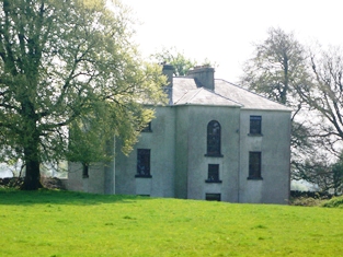
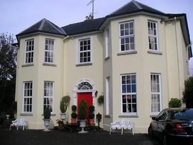
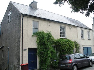
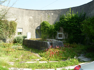
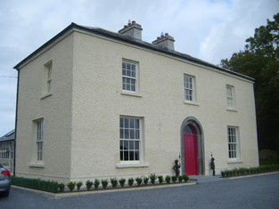
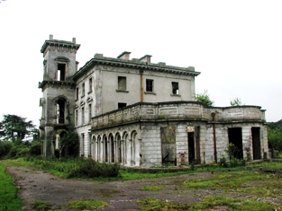
| Mayne Glebe [Mayne Rectory] | Mayne Rectory was leased by Reverend William Eames from the estate of Reverend Thomas Smith at the time of Griffiths Valuation when it was valued at £8. In 1839, the Valuation Office books recorded that it was occupied by Reverend Richard Handy and had a valuation of almost £9. The National Inventory of Architectural Heritage suggests it was built c.1812. It is still extant and in use. |
![Photo of Mayne Glebe [Mayne Rectory]](https://landedestates.ie/storage/img/orig/3615.png)
|
| Mayne House | In 1837 Brian Sheehy was resident at Mayne and in the early 1850s Bernard Sheehy held the house valued at £21+ from John Duggan and all the townland of 107 acres. It is no longer extant. | |
| Meadstown | Burke's ''Landed Gentry of Ireland'' (1904) records the Franks family of Maidstown, county Cork. Hajba dates the present house circa 1860 replacing an earlier house. At the time of Griffith's Valuation the Reverend James Golden occupied Meadstown which he held from Henry Franks. The buildings were valued at £10.15 shillings. This house is still occupied. |