Browse Houses
Search Results: Returned 5927 records. Displaying results 3601 – 3700
| House name | Description | |
|---|---|---|
| Lake Mount | In 1848, the representatives of William Hobbs were leasing this property from Capt. Thomas Roberts, when it was valued at almost £16. | |
| Lake View (Ematris) | This house looks out on Long Lough. It was occupied by William Richey and valued at £10, circa 1860. Home of the Gillespie family in the early 20th century. |
|
| Lake View (Gaultiere) | Izod Tulloh was leasing this property from the Morris estate in 1848 when it was valued at £17 10s. The Tullohs were a naval family who appear to have married into the Morris of Belle Lake House family. | |
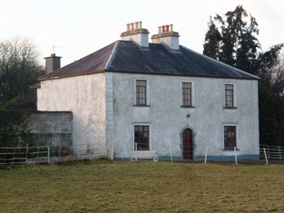
| Lake View (Munterconnaught) | In 1814 the Reverend Nicholas Goslin occupied Lake View, Mountnugent, close to the shore of Lough Ramor. The house is named on the first edition six inch Ordnance Survey map (publ. 1837). In August 1847 T. Drapes, a medical doctor, died at Lake View, Mountnugent, of typhus fever (The Medical Times, XVI, 542). James Blakely was the occupier in the mid-19th century holding the property from the trustees of the Marquess of Headfort. The buildings were valued at £12.10.0. for rates. This house is still extant with an extensive courtyard of outbuildings. | |
| Lake View (Scrabby) | Lake View in the townland of Bernyhill (212 acres) was the home of the McManus family. In the mid-19th century Eugene McManus held the property, valued at £11.10.0. in fee. He owned the townland of Bernyhnill in 1876. Eugene Mc Manus, aged 39, was resident at Lake View in 1901 and in 1911. A house surrounded by farm building is still extant at this site. | |
| Lake View House (Drumlane) | Home of Richard J. ‘Hynes’ (Hinds) at the time of Griffith’s Valuation, Lake View House was held in fee and had a rateable valuation of £10. It was built after the first Ordnance Survey of the 1830s and before the primary valuation survey. Henry Hinds in 1901 and Mrs Charlotte E. Hinds in 1911 held a vacant house in Deramfield. Lake View House is presently occupied. |
|
| Lakefield | Lakefield House was associated with the Crofton family since the mid eighteenth century . A new house was constructed between 1771-1798. At the time of Griffith's Valuation it was leased by Duke Crofton from Hugh Carmichael,M.D. and was valued at £25. The house continued in Crofton ownership until 1931 when the estate was purchased by the Land Commission. It is now a ruin. | |
| Lakefield | In 1786 Wilson refers to the seat of Nicholas Reddington, situated near the lake. He may be referring to this house whch he says was "daily improving in beauty and commands a very extensive prospect". Home of James Fox in the 1830s. Occupied by John Commins at the time of Griffith's Valuation, leasing from the de Clifford estate. The house was valued at £8 at that time. It is still extant. | |
| Lakefield (Middlethird) | Gambonstown was occupied by B.B. Bradshaw in 1814. In 1786 Wilson had referred to it as the seat of Mr. Hackett. The National Inventory of Architectural Heritage records the building of Lakefield house in 1831 by William Pennefather, replacing the former Hackett home of Gambonstown. and the Ordnance Survey Name Books record it as his residence in 1840. At the time of Griffith's Valuation William Pennefather held the house valued at £48.14 shillings and 413 acres from Mrs Hackett and others. Sold by the Pennefathers to the O'Briens in 1907 and sold again to the Goodbodys in 1955. Lakefield is still extant. |
|
| Lakefield/Keoltown House | This house is named Lakefield on the first edition OS map and Keoltown House on the 25 inch map. Near the northern shore of Lough Ennell this five-bay two-storey over basement house was built about 1800 and substantially altered about 1885, with the construction of a new entrance block to the front of the existing house, (boi). This house was a L’Estrange home in the early 19th century. John L’Estrange was resident in 1814. By the time of Griffith’s Valuation (publ. 1854) John Swift was the occupier holding the house valued at £14 from John Charles Lyons. The L’Estrange and Swift families were related. John Swift of Keoltown owned 454 acres in the 1870s. The Swifts were still living at Keoltown at the time of the 1901 and 1911 censuses. The buildings were valued at £29.5 in 1906 and held with 457 acres of untenanted land. This house was for sale in 2020. |
|
| Lakeland | John Ormsby, a younger son of Thomas Ormsby of Ballinamore, lived at Lakeland at the beginning of the 19th century. At the time of Griffith's Valuation, it was leased from Lord Kilmaine by Peter Rutledge Phibbs and valued at £5. It is no longer extant. | |
| Lakelands | At the time of Griffith's Valuation, Richard Beecher was holding this property in fee when it was valued at £8 10s. Lewis noted Lakelands as the seat of T.J. Hungerford in 1837 while Leet states that it was the residence of Timothy O'Driscoll in 1814. Lakelands was included in the sale of the Beecher estate in the Encumbered Estates Court in February 1852. Reverend Isaac Reeves was the owner of a house here in 1906 which was valued at £20. In 1943 the Irish Tourist Association Survey noted that Lakelands had formerly been occupied by Hungerfords and Fergusons and was then the home of Mr. Kingston. The house is still extant. | |
| Lakelands (Clontibret) | A building was located at this site on the 1st edition 6 inch Ordnance Survey map (1836). It was later extended. At the time of Griffith’s Valuation the buildings were valued at £11. It appears to have functioned as a priests’ house as it was held by the representatives of the Reverend James Duffy from Edward Lucas. In the early 1901 the Reverend Thomas Duffy, a Roman Catholic priest, was head of the household and in 1911 the Reverend Thomas O’Doherty. | |
| Lakemount | John Callaghan was leasing this property from Edward Fuller at the time of Griffith's Valuation, when it was valued at £5 10s. There is still a house at the site. | |
| Lakemount (Kinneigh) | John J. Baylis, MD, was leasing Lakemount from the Devonshire estate in 1851, when it was valued at £14. It is still extant and well-maintained. |

|
| Lakemount House | Samuel Millner was leasing this property to Benjamin Millner at the time of Griffith's Valuation, when it was valued at £ 6 10s. In 1814 Leet notes Lakemount as the seat of George Beamish. There is still a house at this site. |

|
| Lakeview | Located on the southern outskirts of Midleton town, Swithin Fleming is recorded as the occupier of this house on the Midleton estate and 12 acres from at least 1837 until the 1870s. In the mid 19th century it was valued at £14. | |
| Lakeview | Occupied by Miss Allen in 1837 and by William Prittie Harris in the early 1850s when the house was valued at £28 and held from Sir William Chatterton. In the 1870s Richard Harris of Lakeview, Cork, owned 169 acres. This house no longer exists. | |
| Lakeview | Henry D. Head occupied a house valued at £14+ in this townland in the mid 19th century. He held the property in fee. A house and large farmyard are now located at this site. | |
| Lakeview | Built by the Carr family and occupied by Michael Carr at the time of Griffith's Valuation when the house was valued at £13. A house is shown though not labelled on the 1st edition Ordnance Survey Map. It is named as Lakeview House on the 25-inch edition of the 1890s. Lakeview is still extant. |
|
| Lakeview | At the time of Griffith’s Valuation, James O’Connell was leasing the property from the Herbert estate when it was valued at £13. Lewis calls the house Lakeville in 1837. Leet also mentions a house called Lakeville in 1814 which he refers to as the residence of Francis Russell. Bary states that the existing house was built by James O’Connell in 1870 after he was made a Baronet but that there was an earlier house here also. The latter is mentioned as the residence of Mr. O'Connell in the Ordnance Survey Name Books of the 1830s. It was built in 1740 and located in the southern end of the townland. In 1894 Slater refers to Lakeview as the residence of Sir Maurice J. O'Connell. The house is still extant. |

|
| Lakeview (Garrison) | A house on the Farnham estate, named on the first edition Ordnance Survey map (publ. 1837), valued at £11.10.0. in the mid-19th century when occupied by Edward Soren and held from David Kellett. | |
| Lakeview (Kilfaughnabeg) | Leased by Martha Raclaud from the Baldwin estate in 1851 when it was valued at £8. It is labelled Lake View on both the First and 25-inch Ordnance survey maps. A house is still extant at this site. | |
| Lakeview (Kilmacallan) | Johnston states that Lakeview House was built sometime in the 1780s. It is recorded as a seat of the Weir family throughout the nineteenth century. At the time of Griffith's Valuation it was held by the representatives of William Weir and was valued at £10. Johnston asserts that the house was sold in 1863 and was occupied in the 1870s by Bernard Cogan. It is no longer extant. | |
| Lakeview (Mohill) | At the time of Griffith's Valuation William Slacke was leasing a property valued at £8 at Drumdart, barony of Leitrim, to William Lawder. | |
| Lakeview (Mullagh) | The nucleus of this house is believed to date back to the mid-17th century and since that time has remained in the possession of the Mortimer family and their descendants. Leet lists David Mortimer as resident and Lewis records Lakeview as a Mortimer home. Griffith’s Valuation names Charles Mortimer as the occupant and owner. The buildings were valued at £11. In 1906, David A Mortimer held about 500 acres of untenanted land and buildings valued at £11.15.0. Since the mid-1990s Lakeview has been the home of Jonathan and Daphne Shackleton and they have restored the gardens. |
|
| Lakeview House (Fore) | John Smith was leasing this property from Reverend Thomas Smith at the time of Griffiths Valuation when it was valued at £15. The Valuation Office books of 1838 state that the house then held by Reverend Thomas Smith was valued at £16. It is still extant and in use. | |
| Lakeview/Clonoony House | On the Griffith’s Valuation map Lakeview House is the same building as that named Clonoony House on the 25 inch map (surveyed 1908). Lakeview was occupied by David Smyth from at least the 1830s and held by him in fee. The buildings were valued at £20. It was the home of the Garland family in the early 20th century. A roof extension and portico have recently been added to this house. | |
| Lambert Lodge (Kilquain) | In the 1830s Kilquain was described as "Proprietor J. W. H. ambert, Esqr., Aggard. No agent. This townland is farmed by Carbit Lambert, Esqr. Proprietor's brother, and on which is built a superb house and offices under a bulk rent of £200 per year. There is a garden and orchard and an interesting demesne". In 1855 the Lambert house at Kilquain was occupied by Cuthbert Lambert leasing from John Lambert. It is still extant and occupied. |
|
| Lancaster House or Lancaster Park | Home of Thomas Lancaster in 1814. Thomas Lancaster was leasing a property at Suckfield, barony of Moycarn, valued at £17, to Robert H. Orr, at the time of Griffith's Valuation. Extensive remains of the stable block still exist at the site. In 1786 Wilson refers to "Suckville", the seat of Mr. Lynch. |
|
| Lancet Lodge | The Puxley estate owned two houses in this townland at the time of Griffith's Valuation, in 1852. One, valued at £14 10s, was leased by John Greenway. It is labelled Dispensary on the 1st edition Ordnance Survey map and as Lancet Lodge on the 25-inch edition of the 1890s. The house is still extant and occupied. The second property, valued at £10, was leased by Phillip Armstrong. It is not labelled on the 1st Edition Ordnance Map. [Grid Reference approximate] | |
| Landscape | The Reverend M. Lloyd Apjohn was the occupier of this house at the time of Griffith's Valuation. He held it in fee and it was valued at £21. The original house is not extant and a modern building has been constructed at the site in this century. | |
| Landscape | This house was held by the Foot family from the Hills by a lease dated 1789 for 3 lives renewable for ever. Occupied by James Hammond in 1837 and in the early 1850s Thomas Bailey was resident holding the property valued at £10.15 shillings from Miss Hill. In the sale rental of 1858 the tenants are given as Margaret and Lucinda Foot. |
|
| Landscape | A house facing the River Shannon, the original house was built in the early 19th century but was remodelled into the current Tudor style c.1917. The residence of Reverend William Friend in 1814, P.W. Creagh in 1837 and of Standish Thomas O'Grady in the 1850s who held it from Elizabeth Creagh. This house is still extant. In 2013 it was offered for sale. |
|
| Landscape House | John Congreve held Landscape in fee in 1850 when it was valued at almost £20. Lewis also refers to it as a seat of the Congreve family in 1837. However, by 1906 Congreve's buildings at Landscape were only valued at £2. Landscape House is still extant and occupied. |
|
| Landsdown | In 1786 Wilson refers to "Land's-town" as the seat of Mr. Rolleston. The home of W. Parker in 1814 and of Mrs Parker in 1837. In 1840 the Ordnance Survey Name Books refer to "Landstown, a good dwelling house, the residence of William Parker". He was also the occupant in the mid 19th century when the house was valued at £55+ and held in fee. John Parker of Brookfield and Landsdown married Helena, daughter of George Washington Biggs of Bellevue. The Parkers were still resident in the 1870s. Bassett's Directory of 1889 refers to Charles E. Tuthill of Landsdown. In the 20th century the home of the White Spunner family. This house, built in 1779, was for sale in 1991 (see ''Country Life'' Volume 185). It is still extant. |
|
| Lanesborough Lodge | This house was built after the first edition six inch Ordnance Survey map (publ. 1837) was compiled. The National Inventory of Architectural Heritage states that the original house was extended by Henry Cavendish Butler in the 1840s. In the 1850s it had a rateable valuation of £38 and was owned and occupied by the Earl of Lanesborough. The lodge was situated in Quivvy Wood located on a peninsular of land that jutted out into the River Erne, north east of Belturbet. By 1906, its rateable valuation had risen to £52. It was burnt in the early 1920s and still stands as an impressive ruin, see archiseek.com | |
| Lanespark | The home of the Lane family from the 18th century,Wilson refers to it as the seat of Hamilton Lane in 1786. Held by John Lane in 1814 and by his representatives in the early 1850s, when the house was valued at £26. The sale rental of 1858 describes the farm offices as extensive and that a powerful steam engine had been erected. Lanespark House is still extant. | |
| Langley Lodge | In 1840 the Ordnance Survey Name Books refer to Langley Lodge as "a good house with offices and garden". This house was occupied by Mrs Mary Langley in the early 1850s. She held it from Henry Langley and the buildings were valued at £19.19 shillings. By the time of the sale in December 1853 John Kane was resident. A building is still extant at this site. | |
| Lansdowne Lodge | William S. Trench, Lord Lansdowne's agent, was occupying this property at the time of Griffith's Valuation, when it was valued at £27. In 1837 Lewis refers to it as the residence of the then agent, J. Hickson. Bary states that it was the home of the various agents of the Lansdowne estate throughout the nineteenth and early twentieth centuries. It was demolished in the latter decades of the twentieth century and a housing estate built on the grounds. | |
| Laputa | Laputa was occupied by Robert Johnstone at the time of Griffith’s Valuation, when he was leasing it from the Conolly estate. It was then valued at £30. In 1837 Lewis had recorded it as the seat of J.F. Johnstone. It was one of a number of properties demolished in the mid-1940s when several townlands were inundated as part of the Erne Hydro-Electric scheme. | |
| Laputa | Laputa was occupied by Robert Johnstone at the time of Griffith’s Valuation, when he was leasing it from the Conolly estate. It was then valued at £30. It was one of a number of properties demolished in the mid-1940s when several townlands were inundated as part of the Erne Hydro-Electric scheme. | |
| Laputa/Glen Barrahane | Thomas Somerville was leasing this property to William Hicks at the time of Griffith's Valuation, when it was valued at £12. Gifford Lewis states that "Glen Barrahane was a rambling conglomeration of extensions to what was once a simple house called Laputa.". It became the home of the Coghill family later in the nineteenth century. | |
| Laragh (Aghnamullen) | A house originally associated with the linen industry, the Ordnance Survey Field Name Book refers to Laragh as the property of Mr W. Intire of Belfast, containing the residence of the proprietor of the bleaching green Mr Davidson. Lewis also records A. Davison as resident at Laragh. Eliza McKean was the occupant of the house valued at £20 in the mid-19th century. She held the property from George McTear. The National Inventory of Architectural Heritage indicates that the present house was built circa 1860 on the site of an older house. The McKean family were still resident in 1901 and 1911. The 'mansion house' had a rateable valuation of £20 in 1906 when James M'Kean held 142 acres of untenanted land in Laragh and Cornacarrow. |
|
| Laragh and Ross | The residence of Thomas Tighe in 1814. In 1830 held in fee by the Mahons of Cavetown. At the time of Griffith's Valuation occupied by Patrick Joseph O'Connor who held the house from Patrick O'Connor. Modern farm buildings occupy the site now. | |
| Laragh House | In 1851 Edmund Murphy was leasing this property, then valued at £28, from the Devonshire estate. There was a mill adjacent. Lewis records it as the residence of I. Swanton in 1837. It is still extant and part of a large farming enterprise. |

|
| Larch Hill | A house valued at £20 at the time of Griffith's Valuation and occupied by Captain Charles William Gore, fourth son of Francis Gore of Derrymore. He held the property from Lucinda Finucane. Later leased by the Finucanes to Charles Armstrong, fourth son of William Henry Armstrong of Mount Heaton and New Hall. A new house built in the 1980s now occupies the site. |

|
| Lareen | Lareen House was built in the 1820s by Luke White who died in 1854 and is buried in the old cemetery in Kinlough, the only member of the White family to be buried in the locality. Lareen then passed to the Massy family of county Limerick (Baron Massy of Duntrileague). In 1906 it, together with about 1200 acres of untenanted land in the area, was the property of Lord Massy. The house was valued at £23 at the time. Lareen was sold in the early 20th century to Maxwell Blacker Douglass who also bought fishing rights on both banks of the Drowes river and Bundrowes House. Lareen House burnt down in 1933. The Irish Tourist Association survey of 1943 mentions that it was in a ruined condition due to this fire. | |
| Larkfield | In 1786 Wilson refers to Larkfield as the seat of Mr. Donnell. Larkfield is described as a very plain house but nevertheless its construction is alleged to have caused financial embarrassment for the O'Donnell estate. It was valued at £15 at the time of Griffith's Valuation when it was occupied by John O'Donnell. After the purchase of the estate by the Land Commission in the 1930s the house was demolished and another house has been constructed on the site. | |
| Larkfield | Leet indicates that Archibald Fleming resided at Larkfield. | |
| Larkfield House | Larkfield House, situated in the southern half of the small 17 acre townland of Clonmoyle, its demesne was situated to the south in the townland of Vilanstown. It is named on the first edition OS map. In 1837 it was occupied by Francis Pratt Smyth, who was also resident at the time of Griffith’s Valuation (publ. 1854) when the house was valued at £20.15 and held from Frederick Lestrange. Larkfield was still in the possession of the representatives of the Rev Samuel L’Estrange when it was part of a sale of Violetstown in the Encumbered Estates Court on 4 July 1874. Mrs Henrietta Hodson and her daughter occupied the house in 1901 and in 1911. The site is now a green field. | |
| Larkfield House | Built circa 1780, this house was the home of Joseph Sproule at the beginning of the 19th century. Bought by Edward Larkin in 1839 and sold to John Holton in 1873. A succession of owners followed until it was bought by the Naughton family in 1923. | |
| Larkhill | A late nineteenth century house which replaced an earlier residence on an adjacent site. Held by the Greer family from the Perceval estate at the time of Griffith's Valuation, when the house was valued at £1. The property was later acquired by the Bell family who built the existing house. Purchased in the twentieth century by the Taylor family and still extant and occupied. | |
| Lassinah | John Day Stokes was leasing this property from Sir Edward Denny at the time of Griffith's Valuation, when it was valued at £20 10s. Bary states that Major Stokes retired here from his Indian Army post and renovated the house where he lived until 1862. It remained in the Stokes family until the end of the nineteenth century and was recorded by Slater as the seat of Maj. Oliver R. Stokes in 1894. It is still extant but ruined. | |
| Latoon House | A 19th century house on the O'Brien estate, occupied by John Lynch in the mid 1850s and valued at £18. | |
| Lauragh | Matthew Walsh was leasing this property from the Musgrave estate at the time of Griffith's Valuation, when it was valued at £12. | |
| Laurel Bank/Holly Bank | This house, originally known as Laurel Bank, is named on the first edition six inch Ordnance Survey map (publ. 1837). It is shown in a demesne which included an old bleach mill and a corn mill and kiln. It is believed to have been built by a mill owner in the 18th century. Griffith’s Valuation records William Norton as the occupant holding the property valued at £8.10.0. from the Earl of Gosford. The house is called Holly Bank on the 25 inch map. Altered and added to in the 20th century it continues to be a residence. | |
| Laurel Bank/Holly Bank | This house, originally known as Laurel Bank, is named on the first edition six inch Ordnance Survey map (publ. 1837). It is shown in a demesne which included an old bleach mill and a corn mill and kiln. It is believed to have been built by a mill owner in the 18th century. Griffith’s Valuation records William Norton as the occupant holding the property valued at £8.10.0. from the Earl of Gosford. The house is called Holly Bank on the 25 inch map. Altered and added to in the 20th century it continues to be a residence. | |
| Laurel Hill House | Another house on the outskirts of Castleblayney, occupied by Henderson Persse and held from Andrew M’Math circa 1860 when it was valued at £20. It was located on the Hope estate and is now part of the Convent of Mercy complex of buildings. | |
| Laurel Lodge | In the mid 19th century Vernon Lamphiere occupied a house in the townland of Moycarky held from William Max and valued at £13.5 shillings. A house is still extant at the site. | |
| Laurel Lodge (Ballymahon) | At the time of Griffith’s Valuation in the 1850s, the property at this site was described as a herd’s house with a value of £4. It was occupied by Edward Phillips, leasing from the King Harman estate. A larger house was later erected on the site and is still extant. |
|
| Laurel Lodge (Shrule) | Thomas Hussey was occupying this property at the time of Griffiths Valuation in the 1850s, when it was valued at just over £10. In 1838 the original Valuation Office books noted the occupant as Edward Nugent. The Ordnance Survey name books of the mid 1830s state that the townland was part of the Ledwith estate. The house is not named on the 1st edition OS map but is labelled Laurel Lodge on the 25” map of the early 20th century. It is now a ruin. | |
| Laurentinum | A mid 18th century house, seat of a junior branch of the Creagh family until the mid 19th century. Wilson refers to Laurentinum as the seat of Mr. Creagh in 1786. At the time of Griffith's Valuation occupied by Stephen Fagan who held it from the representatives of Michael Creagh. The buildings were valued at £32. Later sold to the MacCarthy Morroghs. Home of the Magner family in the 20th century. |
|
| Laurentum | At the time of Griffith's Valuation, Richard Coughlan was leasing this property from the Villiers-Stuart estate, when it was valued at £11. It does not appear on the 6-inch Ordnance Survey map but is named as Laurentum on the later 25-inch map. There is still an extant house at the site. | |
| Lauriston | A house valued at £40 at the time of Griffith's Valuation and held by Nicholas D. Murphy from Joseph Anderson. | |
| Lavally | Wilson refes to Lavally as the seat of Mr. Lynch in 1786. In 1837 Lavally is recorded by Lewis as the seat of T. Lynch. It was still occupied by him at the time of Griffith's Valuation in 1856 when it was valued at £20. By 1906 Delia Mullin is recorded as the owner. Lavally House is still extant and undergoing renovation. |
|
| Lavally (Kiltartan) | At the time of Griffith's Valuation, the representatives of Vicesimus Knox were leasing property valued at £47, including a mill,to John Langan, at Lavally, barony of Kiltartan. This building is no longer extant. | |
| Lawderdale | The National Inventory of Architectural Heritage survey states that Lawderdale was built in the early 1850s and has a tower which was added in the 1870s. At the time of Griffith's Valuation it was the property of William Lawder and was valued at £18. In 1906 it was the property of James Ormsby Lawder and was valued at £30. It is still extant. |
|
| Leabeg | Wilson refers to Leabeg as the seat of Mr. "Irvine" in 1786. The residence of Edward Irwin in 1814 and held by Daniel H. Irwin in fee at the time of Griffith's Valuation, when the house was valued at £6. It is described as "in ruins" on the 25-inch Ordnance Survey map of the 1890s. | |
| Leades House | "Burke's Irish Family Records" states that the Woodleys bought Leades House in the mid 17th century. F. Woodley occupied the house in 1837 and Francis G. Woodley in the early 1850s. He held the property from the representatives of William Woodley and Winthrop Sealy. Slater notes it as the seat of Captain Woodley in 1894 and the Woodley family still occupied this house in the early 20th century. A house is still extant at the site. |
|
| Leadinton | The home of the Atkin family for most of the 18th and 19th centuries. In 1786 Wilson refers to it as the seat of Mr. "Arkin". Valued at £16.15 shillings at the time of Griffith's Valuation, it was occupied by the Reverend Joseph Wright and held from J.T. Atkins Swanne. | |
| Leam | The residence of Mrs Nash in 1814. Described as a two-storey thatched cottage at the time of the first Ordnance Survey and inhabited by a farmer. At the time of Griffith's Valuation the townland was in the possession of Maria and Letitia Bingham but there is no house with a sutstantial valuation. Some farm building remain at the site. | |
| Leamaneigh More | Occupied by Patrick J. Coffey at the time of Griffith's Valuation and held from Sir Edward Fitzgerald. The buildings were valued at £10. During the 1940s this property seems to have been known as Waverley. An extensive farm is extant at the site. | |
| Leamcon House | At the time of Griffith's Valuation, William Hull held this property in fee when it was valued at £20. It had also been noted by Lewis as the seat of the Hull family in 1837. In 1814 it was the residence of R.E. Hull. The 1st-edition Ordnance Map also indicates the site of Old Leamcon House as well as a defensive battery. Leamcon House is still extant and occupied. |
|
| Leamlara | The seat of a branch of the Barry family for over two centuries, the house was demolished in 1966. At the time of Griffith's Valuation it was valued at £36 and held by Penelope Barry in fee. In the sale rental of 1851 the house is described as "built on a porous rock, which keeps the ground floor always dry". In 1906 the house was occupied by Henry S. Barry. The location of this house now appears to be close to or part of a reservoir. |
|
| Leckaun | John Power was leasing this property from Viscount Doneraile's estate in 1848 when it was valued at almost £14. A farm is still extant at the site. | |
| Ledwithstown House | In 1837 Lewis referred to Ledwithstown House as the seat of W. Ledwith. Leet's Directory referred to it as the residence of Richard Dillon in 1814. By the time of Griffiths Valuation in the 1850s, it was held in fee by Edward Ledwith and valued at £15. The National Built Heritage Service suggests it was built c.1745 and was possibly designed by Richard Castle. It is still extant. In the 20th century it had become derelict but has been refurbished |
|
| Lee Brook | Francis Raymond was leasing this property to Richard Roland Chute at the time of Griffith's Valuation when it was valued at £30. In 1906 it was owned by Rowland Chute and valued at £30. Bary states that this house was associated with the Chute family and may have been built by them in the eighteenth century. It remained in the family until the 1930s and is still extant and occupied. The 25-inch edition Ordnance Survey map indicates an additional house in the townland, labelled Lee Brook House. A much enlarged version of this building now serves as Ballygarry House Hotel [Q866134]. | |
| Lee Cottage | Marked on the first Ordnance Survey map this house was occupied by Henry O. Seward in the early 1850s when it was valued at £52 and held from the Ecclesiastical Commissioners. Now incorporated into the university. | |
| Leek House | An early 19th century house on the Leslie estate, marked on the 1st edition 6 inch Ordnance Survey map (1836). Occupied by William Cochran at the time of Griffith’s Valuation and with a rateable valuation of £20. Occupied by Samuel Barbour and family at the beginning of the 20th century. |
|
| Leekfield | Leekfield was originally a Wood property which came into the Webb family through the marriage of Sarah Wood to Daniel Webb Webber. It is recorded as his residence in 1814. McTernan notes that the Webber estate, including Leekfield House and demesne lands, was offered for sale by Charles Tankerville Webber in the 1890s. Leekfield was acquired by Michael Higgins, who had been the agent for the Webber estate. It was demolished in the 1960s. | |
| Leemount | The residence of John T. Hartnell in 1814 and of Nicholas C. Brabazon at the time of Griffith's Valuation. Brabazon held the house valued at £72 from St John Jeffreys with 118 acres. The 1870s landowners' records indicate it as owned by Henry Lindsey Young and Slater records it as his residence in 1894. Leemount is still extant. |

|
| Leemount | Leemount was the home of Thomas Coppinger in 1814 and of Thomas Gollock in 1837. In the early 1850s this house was occupied by Thomas H. Broderick, valued at £30, and held from Thomas Gollock. In 1894 Slater refers to it as the residence of Albert Beamish. Leemount is recorded as one of the residences of John Lindsay, eldest son of George Crawford Lindsay of Moorlands, county Down in Walfords (1910). This original house was burnt in March 1921 during the War of Independence when it was the residence of Maria Lindsay, later executed as an informer by the IRA. It was replaced by the existing house. |

|
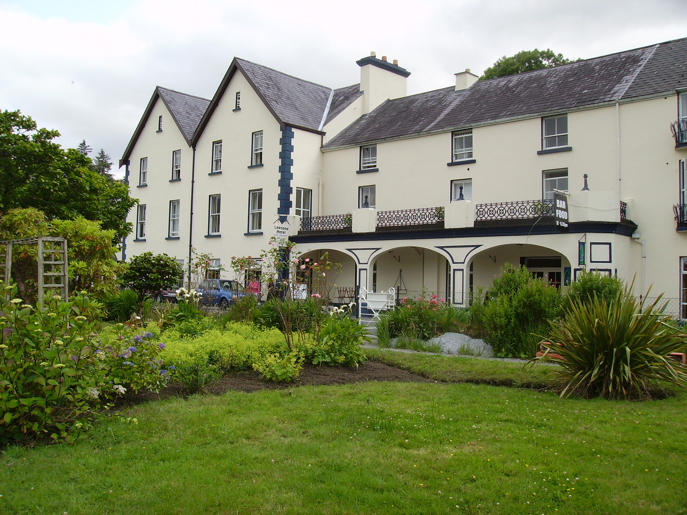
| Leenaun | Tim Robinson writes that Big Ned and his son Big Jack Joyce held large tracts of land and that their home eventually became the Leenaun Inn. Now known as the Leenaun Hotel situated on the south shore of Killary Harbour. The name is sometimes spelt 'Leenane'. |
|
| Leggykelly Cottage | Named on the first edition six inch Ordnance Survey map (publ. 1837), this house was occupied by Theophilus Thompson and held from the Reverend E.B.W. Venables in the 1850s. Its rateable valuation was £5. An extended building now occupies the site. | |
| Lehenagh | Occupied by T. Curtis in 1837. By the early 1850s Mary Curtis was resident holding the house valued at £28 from the Reverend Edward H. Newinham. | |
| Lehenagh House | A home of a member of the Newingham family in 1814 and of Charles Mathew in the mid 19th century.James Mathews of Lehenagh owned 107 acres in the 1870s. This house no longer exists. | |
| Lehenaghbeg | A house valued at £14 in the mid 19th century and held by Edward Casey from James H. S. Barry. Edward Casey was the owner of 121 acres at Lehenaghbeg in the 1870s. | |
| Lehinch | A house marked on the Taylor and Skinner's map but not on the first Ordnance Survey map. In 1786 Wilson refers to it as the seat of Valentine Blake. The walls of the garden still remain and this was the venue for the Hollymount Show at one time. |
|
| Lehinch House | A house on the Stacpoole estate, possibly the house known as Lahinchy occupied by George Stacpoole in 1814 and by A. Stackpoole in 1837. At the time of Griffith's Valuation the house was valued at £10.10 shillings and was occupied by Thomas Moran who held it from Andrew Stacpoole. Weir writes that it was later a home of the Woulfe family. The house no longer exists, a modern bungalow occupies the site. Old walls and outhouses remain. |
|
| Leighmoney House | Lewis records E. Gillman of Leoffney [Leighmoney?], parish of Dunderrow in 1837. John C. Kearney held this property in fee at the time of Griffith's Valuation when it was valued at £15. There is still an extant house at the site. | |
| Leitrim | Home of the Campion family for two centuries, sold by them in the 1870s to Major Victor Reeves of the Castle Kevin family. In 1943 the Irish Tourist Association Survey referred to it as the residence of David Nunan, formerly owned by the Campions, "in their day the house was thatched and much smaller". This 17th century house is still a residence. |

|
| Leitrim House (Achonry) | The 1st edition OS map indicates "Leitrim House (in ruins)" at Leitrim South, barony of Leyny. At the time of Griffith's Valuation Thomas Kane was leasing 85 acres here from the Ormsby Gore estate though the herd's house on the property only had a valuation of 5s. | |
| Lemonfield | In 1786 Wilson writes that Lemonfield was the seat of Sir John O'Flaherty. George O'Flahertie was occupying the property at Lemonfield, at the time of Griffith's Valuation when it was valued at £20. The house is no longer extant. |
|
| Lemonfield House | Sometimes spelt Leamonfield, this house was the home of a junior branch of the Bevan family in the first half of the 19th century. Griffith's Valuation records Thomas Bevan as the occupier holding the property from the Reverend William Lloyd. It was valued at £14. ''Burke's Irish Family Records'' refers to Arthur Russell of Lemonfield, sixth son of John Norris Russell of Limerick. He died 1890. The house is no longer extant. | |
| Lenaboy Castle | This property was held in fee by James O'Hara at the time of Griffith's Valuation when it was valued at £40. In 1786 Wilson refers to a house at Galway which was the seat of Geoffrey O'Hara. Bence Jones describes the house as Tudor Gothic, early to mid 19th century, while the National Inventory of Architectural Heritage notes that the current building is dated 1859. It is now a Health Services facility. |
|
| Leslie Lodge | In 1786 Wilson states that Leslie Lodge was the seat of Robert Leslie "commanding a beautiful view of the river Shannon". Bary writes that Leslie Lodge was located in Shanaway townland and was sometimes known by this name. | |
| Leslie Lodge or Shanaway | Pierce Mahony was leasing this property to James Patterson at the time of Griffith's Valuation, when it was valued at £12. Wilson refers to it as a seat of Robert Leslie in 1786. In 1814 Leet refers to Leslie Lodge as the residence of John Parker. Lewis, in 1837, records the purchase of the property by Col. D.G. Halliburton In 1856, it is included in the sale of the estate of George Phillip Gun Mahony, a minor, when it is described as untenanted. In 1906, Stephen Collis owned a property at Shanaway East, valued at £6. It is no longer extant. | |
| Letter House | John Wren was leasing this property to Alicia Wren at the time of Griffith's Valuation, when it was valued at £13. Lewis records it as the seat of G. Wren in 1837. In 1814 Leet refers to Litter as the residence of John Wren. Bary writes that Letter was originally a Blennerhassett property which passed to the Wren family through marriage., It is still extant and owned by descendents of that family. | |
| Letter Lodge | Reputed to have been a hunting lodge of the Martins of Ross, this herd's house was occupied by William Poe in the 1850s, who held the property from James O'Hara. David Walsh was the tenant of Letter in 1890. In the late 20th century the home of Richard Ward, wildlife artist and still a private residence. |
|