Browse Houses
Search Results: Returned 5927 records. Displaying results 3401 – 3500
| House name | Description | |
|---|---|---|
| Killygordon House | Joseph Johnston was leasing this property from James Johnston at the time of Griffiths Valuation in the 1850s, when it was valued at £20. The site is labelled Killygordan Demesne or Weddingtown, on the first edition Ordnance Survey map of the 1830s. It is labelled Killygordan House on subsequent editions. The National Inventory of Architectural Heritage suggests the original house was built in the later eighteenth century but subsequently modified. It was associated with the Mansfield family originally but with the Johnstons by the latter half of the nineteenth century. It is still extant and occupied. |
|
| Killynan House | Killynan House was located on the border between the two Killynan townlands of Pratt and Cooke. It was the home of the Reynell family who held it from the Winter family. Reverend Edward Reynell is recorded on the Taylor and Skinner maps of the late 1770s and was resident until his death in 1788. He was succeeded by his son Richard who occupied the house in 1814 and 1837. Richard was later succeeded by his son, Richard Winter Reynell, who died in 1887. The Reynells were related to the Winter family. This house is now demolished but outbuildings survive. |
|
| Killywilly House | Killywilly House located between Loughs Killywilly and Cuillaghan is named on the first edition six inch Ordnance Survey map (publ. 1837). A corn mill and bleach mill were nearby in the townland of Ardue. James Berry was the occupier in the 1850s. He held the property from James H. Story and the buildings had a rateable valuation of £18. There is still an extant house at the site. | |
| Kilmacabea Mill | John Sheehan was leasing this property from the Bennett estate in 1852, when it was valued at almost £13 and included a mill. A corn mill, then disused, is shown on the 25-inch Ordnance Survey map of the 1890s. A building still exists at the site. | |
| Kilmacow | Located on the Devonshire estate, on the Cork/Waterford border, Kilmacow was occupied by John Boyce in 1814 and by William John Day in the early 1850s. The buildings were valued at £12. Bought by John Murphy of Tallow in the late 19th century and still extant. |
|
| Kilmacreddan House | At the time of Griffiths Valuation, Sophia Major was leasing this property from the Barton estate, when it was valued at £9. In 1868 it was offered for sale in the Landed Estates Court by Sophia Keane when the petitioner was Alexander Buchanan. Kilmacreddan is still labelled on the last edition of the 6-inch Ordnance Survey map but is no longer extant. | |
| Kilmacurkan | In 1906 John L. Brinkley owned property valued at £20 at Kilmacurkan, barony of Tireragh. At the time of Griffith's Valuation the only building on his lands here was a herd's house valued at 5s. A substantial building is indicated on the 25-inch Ordnance Survey map of the 1890s but no trace of this remains now. Local sources indicate that this was a scutch/flax mill, of which the ruins still stand including the traces of the flax ponds, various sheds, etc that are present on the 1890 map. | |
| Kilmaglish | Kilmaglish House not built at time of first edition OS map but is marked on the 25 inch map. At the time of Griffith’s Valuation (publ. 1854) it was valued at £17, occupied by William Levinge and held from Sir Richard Levinge. Occupied by Thomas Robinson, a farmer and his son William in 1901 and 1911. It is still extant surrounded by large farmyard. | |
| Kilmainham - The Cottage/Heath Lodge | Ambrose Leet records Kill, Mount Nugent, as the residence of George Lenauze. Kill House, located on the estate of the Bishop of Kilmore, is named on the first edition 6 inch Ordnance Survey map (publ. 1837). At this time there were laid out gardens and extensive plantations within the demesne grounds. The buildings at Kill House are reduced in size on the later 25 inch map. In the 1850s, Garrett Keogh was the occupier holding the property valued at £5 from John Orpen. This house is no longer extant. | |
| Kilmainham - The Cottage/Heath Lodge | Lewis refers to Kilmainham as the residence of A. Bell and the house is named as The Cottage on the first edition 6 inch Ordnance Survey map (publ. 1837). By the time of Griffith’s Valuation about 20 years later, Henry Montford was the occupier, holding the property from William Humphrys of Ballyhaise. The building would appear to have been extended by this time as its rateable valuation was £15. The house is named Heath Lodge on the 25 inch map. James Hartley and family were resident at Heath Lodge in 1901 while Hector John Atkinson and his wife Sybil were the occupants in 1911 holding the property from the representatives of James Harley. A building of similar shape still exists at this site. | |
| Kilmaloda House | Thomas Beamish held this property in fee at the time of Griffith's Valuation, when it was valued at £50. In 1837, Lewis refers to it as the seat of Sampson Beamish. In 1906 it was owned by Sampson Beamish and valued at £68 15s. Local sources suggest it was built by the earlier Sampson Beamish and occupied by his descendents until the mid twentieth century when it came into the hands of the McCarthy-Murrough family. It is still extant and occupied. In 2013 it was offered for sale. |

|
| Kilmanahan Castle | Robert Sparrow was leasing this property from the Greene estate in 1850 when it was valued at over £72. It was offered for sale as part of William Greene's estate in July and December 1852. The sale notice includes a lithograph of the castle. It was bought by Alexander Glasgow who sold it on to the Earl of Donoughmore in 1855. Earlier, in 1786, Wilson notes it as the seat of Mr. Greene. In 1837, Lewis refers to it as the seat of Lt. Col. Nuttall Greene. Hussey records Thomas Wright Watson of Kilmanahan Castle in the mid 1870s. In 1906 it was part of th Donoughmore estate and valued at £45. It is still extant. |
|
| Kilmeen Glebe (East Carbery) | Reverend Edward Alcock was leasing this property from the Ecclesiastical Commissioners in 1851 when it was valued at £23. Lewis notes that there were large plantations around the house in 1837, when it was the seat of Reverend E.H.Kenney. In 1944 the Irish Tourist Association Survey reported that it was then the residence of Rev. Gorman. Buildings are still extant at the site. | |
| Kilmoney Abbey | At the time of Griffith's Valuation, Michael Roberts was leasing this property from Thomas R. Sarsfield, when it was valued at £50. Lewis referred to it as the "handsome residence" of Michael Roberts in 1837. It is stil extant and well maintained. Thomas Sarsfield was leasing a smaller propertyin the same townland, valued at £9, to Eugene McCarthy. There are two properties shown on the 25-inch Ordnance Survey map of the 1890s, Kilmoney House and Kilmoney Cottage. Buildings are still extant at these sites though extensive urban development has occurred in the area. |

|
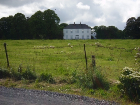
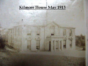
| Kilmore | Brian de Breffny writes that the back section of Kilmore House is part of the 17th century house built by the Moncktons. The front part was built by the Tuthills in the mid 18th century. George Tuthill purchased the house from Edward Monckton in 1737. The Tuthills had previously held it on lease. Occupied by Thomas Lynch in 1814 and by Colonel William Jones in the early 1850s, when the property was held from Elizabeth Tuthill and valued at £15. In 1906 Kilmore was the residence of Anne Isabel O'Grady. This house is still extant and occupied. |
|
| Kilmore | The Bagwell family are described as "of Kilmore" in the 18th century. In 1786 Wilson refers to Kilmore as the seat of John Bagwell. Kilmore is marked in the middle of the townland on the first Ordnance Survey map. This area was divided up at the time of Griffith's Valuation and the only buildings over £10 valuation were a mill, house and offices on the northern perimeter of the townland. | |
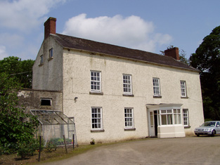
| Kilmore | The National Inventory of Architectural Heritage dates this house from the early to mid 18th century and the Wayland family were resident at this time. Austin Cooper was living at Kilmore in 1837 and at the time of Griffith's Valuation Samuel Cooper was the occupier. He held Kilmore from the Earl of Normanstown and the buildings were valued at £16. This house is still occupied and part of a working farm. |
|
| Kilmore | A house at Kilmore was occupied by the Reverend William Thompson in 1814. Edward Corcoran and John Sadlier held Kilmore valued at £3 in fee at the time of Griffith's Valuation. Edward Kennedy owned the property in the 1870s. The house, which was located just inside the stone pillars, was demolished circa 2004. |
|
| Kilmore | The home of a branch of the Hickman family in the 18th and 19th centuries. In 1786 Wilson refers to it as the seat of Mr. Hickan. Inherited by the Gores in the 1860s. Burnt in July 1922. |
|
| Kilmore | Originally a Shaen property which passed by marriage to the Carters. A house and 4 acres were leased by Sir Arthur Shaen to William Hartly on 3 Aug 1706 (see sale rental 1855). In 1749, 1778 and 1786 it was occupied by the Waller family. The house was a ruin by the 1830s. | |
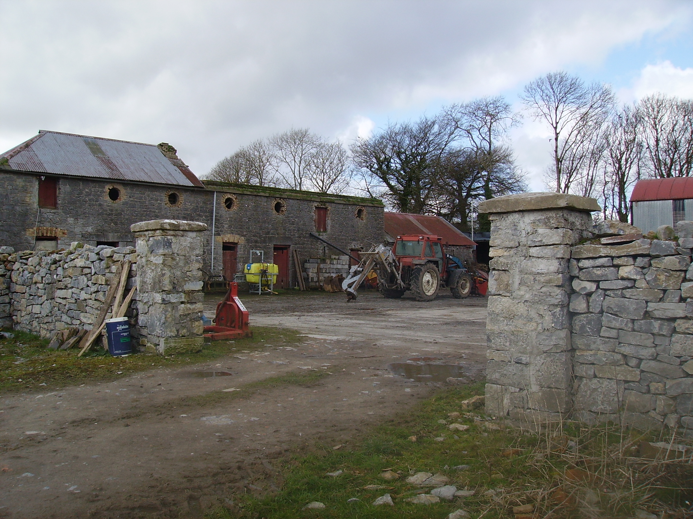
| Kilmore House | Built by the Reverend Edward King, Bishop of Elphin circa 1630. Home of a branch of the Lawder family in the 18th century until the murder of James Lawder in 1779. The Auchmuty family resided at Kilmore in the 19th century. The demesne was named Aghaward on the first Ordnance Survey map. A large farm is still extant at the site. | |
| Kilmore House & Garrettstown Mills (Ballinspittle) | Richard Jago was leasing this property from the Kearney estate at the time of Griffith's Valuation, when it was valued at £16 and included a milling business. By the 1890s Kilmore House is located nearer to the mill which is now labelled Garrettstown Mill (W591454). Kilmore House and portions of the mill building are still extant. | |
| Kilmore House (Bandon) | Michael Curtin was leasing this property from the Devonshire estate in 1851 when it was valued at almost £19. Noted by Lewis, in 1837, and Leet, in 1814, as the seat of William Popham. Local tradition associates this house with Maj. Daniel O'Mahony, participant in the Battle of Cremona, 1702. The original house is not extant. | |
| Kilmore House (Moygoish) | At the time of Griffiths Valuation, Kilmore House was leased by Reverend Francis Kane from Reverend William Bowles and was valued at £10. The house is not visible on the 1st edition OS map but is labelled Kilmore House on the 25-inch edition. It is still extant and part of a farming enterprise. Reverend Francis Kane was afterwards rector of the parish of Fenagh, County Leitrim, from 1869 until his death in 1882. He had previously been vicar in the parish of Russagh, nearby to Street, County Westmeath, 1848-1855. | |
| Kilmore House (Tallow) | Held in fee by Rev. William Percival at the time of Griffith's Valuation, when it was valued at £37. Lewis refers to it in 1837 as "Kilmore Hill, residence of Rev. W. Percival, a handsome seat on the new line of road to Youghal". Wilson, writing in 1786, refers to the Perceval residence near Tallow as "Kilmahoe". In 1906 it was still owned by William Percival and valued at £37 10s. |
|
| Kilmore House (Westmeath) | At the time of Griffiths Valuation, Kilmore House was leased by Reverend Francis Kane from Reverend William Bowles and was valued at £10. The house is not visible on the 1st edition OS map but is labelled Kilmore House on the 25-inch edition. It is still extant and part of a farming enterprise. Lewis noted that the living of Kilmore was in the patronage of Fulke Greville in 1837. Reverend Francis Kane was afterwards rector of the parish of Fenagh, County Leitrim, from 1869 until his death in 1882. He had previously been vicar in the parish of Russagh, nearby to Street, County Westmeath, 1848-1855. | |
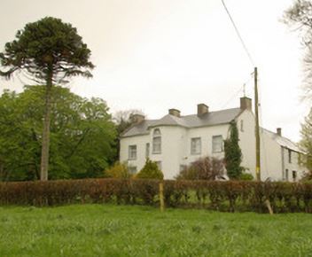
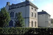
| Kilmore Palace | A house built in the 1830s for Bishop George de la Poer Beresford, designed by William Farrell and resembling Rathkeeny. It replaced an earlier palace on a different site. Its rateable valuation was £100 in the 1850s, the Bishop of Kilmore being owner and occupier. This house continued to be the home of the Bishops of Kilmore until the early 21st century. It is now in private hands and currently for sale (2022), see https://theirishaesthete.com/tag/kilmore/ |

|
| Kilmorgan | Jemmet Duke held 220 acres at Kilmorgan, barony of Corran as well as a property valued at £5 at the time of Griffith's Valuation. Lewis had recorded Kilmorgan as the seat of Robert Weir. McTernan notes that Kilmorgan had belonged to the Trumble family but was sold by them in 1855. The site is now occupied by farm buildings. | |
| Kilmorna House | Pierce Mahony was leasing Kilmorna House to William Lunham at the time of Griffith's Valuation, when it was valued at £23 10s. On the first edition Ordnance Map it is labelled as Kilmeany House. In 1786 Wilson refers to Killlmeny as the seat of Mr. Gunn. Bary states that it was originally a Raymond house, named Riversdale but that it was bought by Pierce Mahony in 1834. Leet, in 1814, refers to it as the residence of Mrs. Raymond. In 1906 it was the property of George Gun Mahony and valued at £20. It continued to be occupied by the Mahony family and their descendents until 1921 when it was burnt and the then resident, Arthur Vicars, shot dead. | |
| Kilmoylan | The home of Richard White in 1814 and of Newport White in the early 1850s, held from the representatives of D. Barrington. The buildings were valued at almost £18. It is no longer extant. | |
| Kilmoyle | A house built by the Boyds, merchants in Limerick city, circa 1845 on the Lansdowne estate and originally known as Westfield. For many years the residence of the Catholic Bishops of Limerick. Sold by the Diocese to Aidan Brooks for development in 2007 for a sum reputed to be > €20 million. |

|
| Kilmoyle | At the time of Griffiths Valuation in the early 1850s, Alexander McCormick was leasing this property from the estate of Captain W. Bond, when it was valued at £7. The 1906 Untenanted Demesnes survey records a valuation of almost £14 for the property when it was still part of the Bond estate. A modern house and large farm occupy the site now. | |
| Kilmoyler | A late 18th century house, the seat of the O'Meagher family, occupied by Dennis O'Meagher in 1814 and 1837 and by Stephen O'Meagher at the time of Griffith's Valuatiton. He held the property in fee and the buildings were valued at £40. In 1865 this property was advertised for sale by the Prestons. The rental records that the house was held on a lease dated 1860 from William O'Meagher to Standish Butler who was resident at the time. In 1786 Wilson had recorded "the castle and house at Kilmoyler, the ancient seat of Colonel Butler". Still extant and occupied. |

|
| Kilmoylerane House | Richard J. Long was leasing this property from the Devonshire estate at the time of Griffith's Valuation, when it was valued at £15. A house and extensive farm buildings exist at the site. | |
| Kilmurray House | Anthony Raymond was leasing Kilmurray House to Catherine McIntosh at the time of Griffith's Valuaton, when it was valued at £18 5s. The Ordnance Survey Name Books describe it as " a handsome house, 3 storeys high" in the 1830s. Bary writes Kilmurray was said to have been built by Archibald McIntosh (Cantoss) around 1839 although it appears earlier than that. By 1870, George Raymond, QC, who resided in Dublin, used Kilmurray as a summer home where his relatives, the McIntosh family resided. It is still extant and in 2008, was offered for sale. |
|
| Kilmurry | A house valued at £11 and held by Eyre Lloyd in fee at the time of Griffith's Valuation, now derelict. |
|
| Kilmurry | The house was built in the early 18th century and remained in the hands of the Grant family until sold to the Rosminian Order in the 1930s. In the 1940s the Irish Tourist Association surveyor was given to understand that the Grants still retained title to the property and were residing in South Africa. In the mid 19th century it was valued at £37 and held by Thomas St John Grant in fee. At the beginning of the 21st century this house was in a dilapidated state. |
|
| Kilmurry (Corkaguiny) | In 1906 Lord Ventry's estate owned this property valued at £6 5s.At the time of Griffith's Valuation, much of the property in this townland was held by Thompson, Lord Ventry's agent. A house valued at £1 4s was being leased from them by Richard Searl and another, together with 48 acres, by Laurence Sullivan. The coastguard station was also located there. . | |
| Kilmurry Lodge | A house valued at £16.13 shillings was occupied by the Reverend Richard Morrissey in the townland of Ballynamona at the time of Griffith's Valuation. It was held from William P. Barker. Kilmurry Lodge is marked on the first Ordnance Survey map and is described in the Ordnance Survey Name Books as "a lodge, handsomely situated, with a garden, orchard and fir plantation". This house is still in use as a residence. |

|
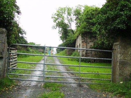
| Kilnaborris Dower House | John Seymour was leasing a property valued at £8 from Hubert Moore at the time of Griffith's Valuation. It was located in the townland of Kilnaborris, parish of Clonfert. Kilnaborris Dower House is still extant and now offered as holiday accommodation. |
|
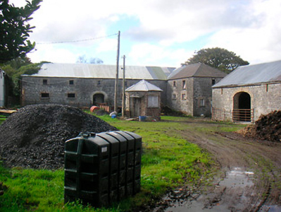
| Kilnacrott Cottage/House | In 1837 Lewis records Pierce Morton as the proprietor of Kilnacrott. This was Kilnacrott Cottage as marked on the first edition 6 inch Ordnance Survey map (publ. 1837). Subsequently a Tudor Revival house was built very slightly to the north of the Cottage for Pierce Morton (National Inventory of Architectural Heritage). Morton sold the house in 1850 to Samuel Moor, who sold it on privately to William Hague. This house had a rateable valuation of £65 at the time of Griffith’s Valuation and was occupied by George H. L’Estrange who held the property from William Hague of Cavan, father of William Hague, architect of Cavan and Dublin. In 1876 William Hague held 459 acres in county Cavan. In the 1880s Kilnacrott became the home of the Lynch family. In 1906, Charles Lynch was resident. He died in 1913 (see will administrations in the National Archives). From 1930 the building was used as a school by the Holy Trinity Priory. In 1954 a grant of arms was issued to the Rt Reverend Felim Cornelius Colwell, Lord Abbot of the Abbey of the Holy Trinity of the Canons Regular of Premontre at Kilnacrott, Co Cavan, and to the Community, see National Library, GO MS 111H: 27-28. Kilnacrott is now known as the Cavan Centre, a ‘Residential Centre for Education and Community Development’, see http://www.cavancentre.ie/ | |
| Kilnagnady House | Leased by John Popham from the Devonshire estate in 1851 when it was valued at £10. There is still an extant house at this site. | |
| Kilnagrange Mills | In 1851 Pierce Barron was leasing this property which included Kilnagrange Mills to Mrs. Catherine Dunn. It was valued at £14. Now the site of Flahavans oat milling company. | |
| Kilnagross | At the time of Griffith's Valuation, William Sullivan was leasing this property to Rev. Somerset Townsend, when it was valued at almost £12. In 1837, it was the seat of Rev. W. Sullivan. It is no longer extant. | |
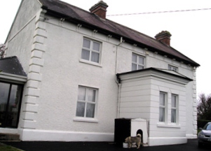
| Kilnahard House | Described by the National Inventory of Architectural Heritage as a castellated country house built circa 1820. Kilnahard is situated on the shore of Lough Sheelin. In the mid-19th century it was occupied by Tuite Dalton, who held the property from Andrew Bell. The buildings had a rateable valuation of £18. This house is still a residence. | |
| Kilnamack | In 1849, the representatives of John Greene were leasing this property to Edward Butler when it was valued at £12 11s. Both Wilson and Taylor and Skinner had also recorded it as a residence of the Greene family in the 1780s. It is still extant and in 2013 was offered for sale. |
|
| Kilpatrick | Hajba writes that Roger Langley leased this property from the Longfields in the mid 18th century. Lewis writes that William J. McCormick, medical doctor,occupied the house in 1837. A boys' school was established at Kilpatrick by the McCormicks. At the time of Griffith's Valuation William J. McCormack held the house valued at almost £10.15 shillings from Christopher Langley. Sir William J. MacCormac was a well known London surgeon, the son of Dr Henry MacCormac of Belfast. The house was occupied until the early 20th century but is now a ruin. | |
| Kilpatrick House | Henry Herrick was leasing Kilpatrick House from the Devonshire estate at the time of Griffith's Valuation, when it was valued at £45. A house still exists here. | |
| Kilpeacon | Lewis writes that the manor was granted to William King in the reign of James I and that "the late proprietor" had erected a handsome mansion which was now the "property and residence of Cripps Villiers". In his will dated 1704 William King refers to his niece Mary Villiers. The Ordnance Survey Field Name Book states that Kilpeacon House was the property of Edward Villiers, Dublin, and was occupied by Miss Deborah Cripps. Built in 1820 it was a large, commodious building of 2 stories. It was the residence of Edward C. Villiers at the time of Griffith's Valuation, held in fee and valued at £60. Bought by Major George Gavin in the early 1850s from the Villiers and the residence of his son Montiford W. Gavin in the early 20th century. The Irish Tourist Association surveyor writes in 1942 that this house was completed in 1799. The owner was Mrs O'Kelly, her husband having purchased the house in 1927 from the Gavins. This house is still extant and occupied. |
|
| Kilquain | At the time of Griffith's Valuation Allen Pollok held a property in Kilquain valued at £5 10s which was used as a steward's house. There is evidence of estate architecture in the vicinity but twentieth century buildings on site. | |
| Kilquane | Charles Blennerhassett was leasing this property to Thomas Rooney at the time of Griffith's Valuation, when it was valued at £3, on a farm of 130 acres. This may be the property to which Wilson refers as the seat of William Blennerhasset in 1786 which he names Elm-Grove. A substantial farm is extant at the site. | |
| Kilroe | The Hanley family were living at Kilroe in the early 19th century and it was the residence of John J. Gunning in the latter half of the 19th century. He had a mill closeby at Inish. |
|
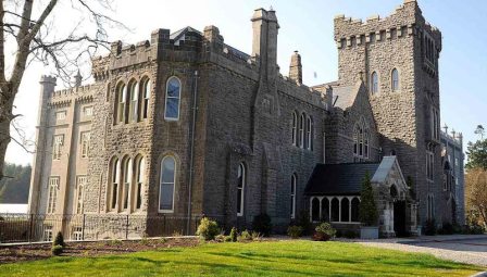
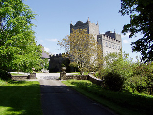
| Kilronan Castle/Castle Tennison | The house presently occupying this site was constructed in the later 19th replacing an earlier house which had been built c.1820. At the time of Griffith's Valuation the house had been valued at £70 and was occupied by Edward King Tenison. In 1814 it was the seat of Thomas Tennison and is recorded by Lewis as the seat of Col. Tenison. In 1894 Slater referred to it as a residence of the Earl of Kingston. The building is still extant and in 2006-7 was converted into a luxury hotel. For more information on Kilronan Castle see www.kilronancastle.ie. |
|
| Kilronane | In 1851 Joseph Bennett was leasing this property to John Jago when it and the adjacent mill were valued at £14. In 1837 Lewis referred to it as the seat of N.B. Jagoe. In the 1870s it was a Tuckey residence. There is still an extant house at the site. | |
| Kilrossanty Mill | In 1851, Mrs. Mary Callaghan was leasing this property, which included a corn mill, from Sir Edward Kennedy's estate when it was valued at £11 10s. The mill building is still extant. |
|
| Kilruane House | A house constructed in the later nineteenth century on lands owned by Sir Mark A.H. Tuite. It is labelled Kilruane House on the 25-inch Ordnance Survey map of the 1890s. In 1894 Slater notes it as the residence of Sir Mark Tuite. It is still extant and occupied. |
|
| Kilrush | In 1840 the Ordnance Survey Name Books refer to Kilrush House as a gentleman's residence, possibly that of a Mr. Fogarty. John Ellis was occupying a house valued at £14 in Kilrush at the time of Griffith's Valuation. He held the property from John Trant who held 210 acres from James Byron. A house is still extant at this location. | |
| Kilrush | A house occupied by Daniel Gabbott and held from Tottenham Harvey at the time of Griffith's Valuation. The house was valued at £40 and was surrounded by 3 acres of land. It was situated on the Barrington estate. [Marked as Thorn Ville on the first Ordnance Survey map]. | |
| Kilrush | A house in the village of Hollymount, leased by Christopher Bowen from Reverend Christopher Bowen's estate at the time of Griffith's Valuation, when it was valued at £25. Only a few walls remain now. |
|
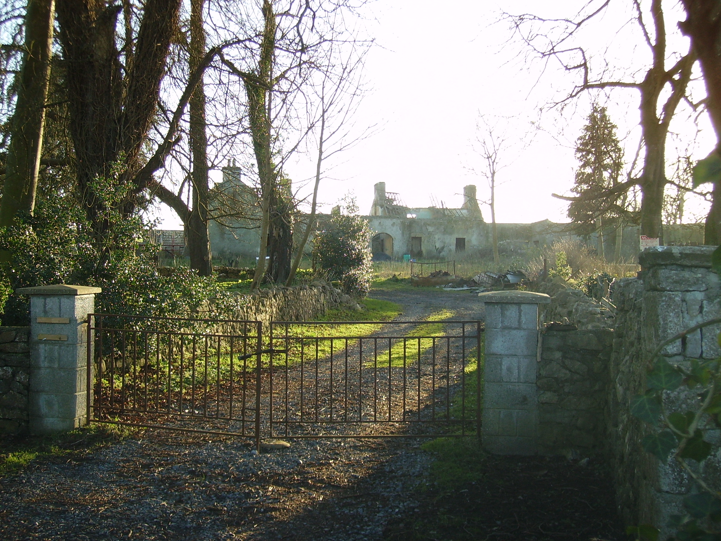
| Kilrush House | Built as an agricultural school in the 1830s, it was not a success and swiftly closed. The property was rented in the 1850s from the Lindseys by Francis Laurie, a farmer from Scotland. He died in 1865 and James Simpson took over the lease. Charles Bingham Jenings and his wife, formerly of Mount Jenings, lived at Kilrush for the first three years of the 20th century. The building is now a ruin. |
|
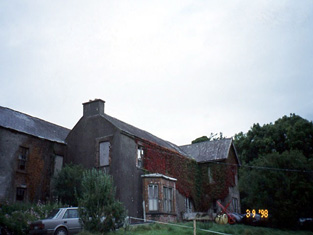
| Kilrush House | Thomas Beamish held this property in fee at the time of Griffith's Valuation, when it was valued at £24. Lewis records it as the seat of A. Poole in 1837. The National Inventory of Architectural Heritage records that an earlier house, built around 1650, originally stood at this site and the extant house may incorporate parts of that earlier structure. |

|
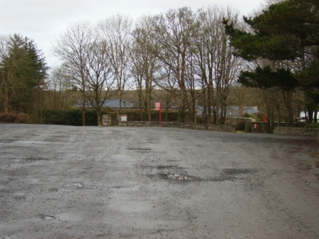
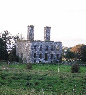
| Kilrush House | An early 19th century house, home of the Vandeleur family, though they were in residence in the eighteenth century as Wilson refers to Kilrush as the seat of Crofton Vandeleur in 1786. In the mid 19th century it was valued at £85. In 1897 it was completely destroyed by an accidental fire. The site of the house is now a car park for those wishing to visit the Vandeleur Walled Garden, which has recently been restored, or to walk in the woods. |
|
| Kilscannell | Occupied by Richard Condon in the 1830s. Located on the estate of Lady O'Brien circa 1840 this was a large house of two stories with offices but in a state of bad repair and unoccupied. It was still vacant at the time of Griffith's Valuation and held by Pierce Brown. | |
| Kilshane/ Spring House | It is not clear where the McCarthy house at Springhouse was located but a building is marked on the first edition Ordnance Survey map as Spring House, later known as Kilshane. In 1786 Wilson refers to Spring House as the seat of Mr. McCathy. Thomas McCarthy resided at Springhouse in 1814. The present house was built in the 1820s by John Lowe and was designed by C. F. Anderson. It continued to be the home of the Lowe family throughout the 19th century. Lewis refers to Spring House the residence of J. Low. Simon Low held the property in fee at the time of Griffith's Valuation when the house was valued at £75. The Lowes were still resident in 1906. This house was renovated and restored in the early 21st century and now functions as a hotel. see http://www.kilshanehouse.ie/Contact.html |

|
| Kilshane/Arraghslea | Kilshane Cottage was occupied by Captain Blackmore in 1837 and noted by the Ordnance Survey Name Books as "the residence of Captain Blackmore, in excellent repair" in 1840. It was occupied by Henry Blackmore in the mid 19th century, when the house was valued at £11 and held from Simon Lowe. The Blackmores were related to the Lowes. This building is named Kilshane on the first edition Ordnance Survey map. Buildings in Kilshane valued at £12 were still in the possession of the Lowe family in 1906. This house later became known as Arraghslea and following a townland boundary change was located in the townland of Springhouse. |

|
| Kilshannig | This house was built for Abraham Devonsher, a Cork banker and Member of Parliament, in the 1760s. It remained the home of the Devonsher family until sold to Edward Roche, father of the 1st Earl of Fermoy, pre 1837. Lewis records it as the winter residence of the Roche family. At the time of Griffith's Valuation it was occupied by James Kelly of Cahircon, son-in-law of Edward Roche, and valued at £58+. In 1943 the Irish Tourist Association Survey mentioned that it was the home of the McVeigh family. The Sardinian architect, Davis Ducart, designed this house and according to the Irish Georgian Society it is considered one of the very finest Palladian houses in Ireland. The Society is currently supporting the restoration of parts of this house. see http://www.igs.ie/Programmes/Conservation-Grants/Kilshannig.aspx |

|
| Kilshanny | Wilson, writing in 1786, refers to Kilshanan as the seat of Captain King. An unnamed property is shown in the townland of Kilshanny on the 1st edition Ordnance Survey map which was later to be the site of Mitchelstown workhouse. It is no longer extant. | |
| Kilshruley House | At the time of Griffiths Valuation in the early 1850s, Major T.N. Edgeworth held this property in fee when it was valued at £20. It is labelled Kilshruley Manor on the 25-inch map of the early 20th century. It has since been demolished. A memorial stone at the site indicates that a castle belonging to the Adair family previously stood near the site. | |
| Kilskeagh | Leet's Directory records Dominick Browne of Kilskeagh in 1814 and a small house is marked on the 1838 Ordnance Survey map. By the time of Griffith's Valuation only a herd's house valued at 10 shillings is recorded. | |
| Kiltallagh Glebe | Rev. Brownrigg (or possibly Browning) Drew was in possession of Kiltallagh Glebe at the time of Griffith's Valuation, when it was valued at £17. Lewis records it as the seat of Rev.J. Murphy in 1837. In 1786 Wilson refers to "Menus"as the house of Dr. Drew but he also refers to a residence of Rev. Dr. Day, near Kiltalla church. Bary mentions that it was renovated by Rev. Murphy earlier in the nineteenth century. It was also associated with the Day and Godfrey families. In 1920 it was sold to the Boyle family by the Representative Church Body and is still extant and occupied. | |
| Kiltanon | Kiltanon was the home of the Molony family for at least two centuries. The house built in 1833 had a drive which linked it to the other nearby Molony residences at Bunavory and Cragg. The house was burnt in September 1920 and is now a ruin. In the second half of the 19th century another house, known as the Home Farm House, was built at Kiltanon for Marcus Molony, eight son of James Molony and his agent. This house is still extant. |

|
| Kilteany Lodge | Built by the Carter family circa 1860 in a townland which was part of the estate of Charles and Bernard Coyne at the time of Griffith's Valuation. It is no longer extant. | |
| Kilteely House | In 1786 Wilson refers to Kilteely as the seat of Mr. McNamara. By the time of Griffith's Valuation, much of this townland is the property of John Ryan jnr. This may be the property occupied by Rev. John Madden and valued at almost £8. Kilteely is shown but not labelled on the 1st edition Ordnance Survey map and is labelled Kilteely House on the 25-inch edition of the 1890s. According to the National Inventory of Architectural Heritage it serves as the local Parochial House. |
|
| Kilteeven House | Still occupied by the Mapothers in 1906, when the house was valued at £20. Some ruined buildings remain at this site. |
|
| Kiltinan | Kiltinane Castle was the seat of the Cooke family in the 18th and 19th centuries. Lewis describes the castle as the seat of R. Cooke, it "consists of an ancient circular tower .... and a residence erected on the old site by the late E. Cooke". In the mid 19th century the buildings were valued at £38+ and held by Robert Cooke in fee. Noted by Slater in 1894 as the seat of Robert Cooke. Sold by the Cookes in the 1920s to Mrs le Terrier, Kiltinan Castle now belongs to Andrew Lloyd Webber. |
|
| Kiltoom | Crofton Kelly bought or acquired the Kiltoom property where he built a house in the mid 18th century. Occupied by Thomas H. Strevens who held a number of townlands from Sarah Kelly at the time of Griffith's Valuation and left to him at her death. Kiltoom remained a Strevans home until the 1970s, now a derelict building. |
|
| Kiltoy Lodge | At the time of Griffiths Valuation in the 1850s William Boyd was leasing this property from the Ecclesiastical Commissioners when it was valued at £22. The building is still extant and apparently in the process of being renovated. | |
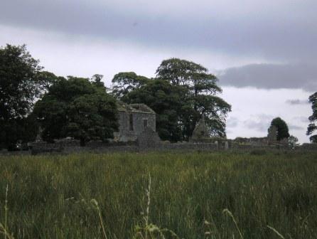
| Kiltullagh House | In 1786 Wilson mentions "Kiltolla" as the seat of Patrick D'Arcy. Lewis records Kiltullagh House as the seat of J. D'Arcy in 1837. At the time of Griffith's Valuation, Pierce Joyce held a herd's house here valued at almost £4. It is described as "in ruins" on the 25-inch Ordnance Survey map of the 1890s and these ruins are still extant. |
|
| Kilturra | At the time of Griffith's Valuation Joseph Verscoyle was leasing a property valued at £6 together with over 300 acres to Bartholomew McGettrick, at Kilturra, barony of Corran. This later became the residence of John Ormsby Cooke. It was partially damaged by fire in 1920 and Cooke eventually abandoned the property which became derelict. It was demolished in the 1930s. | |
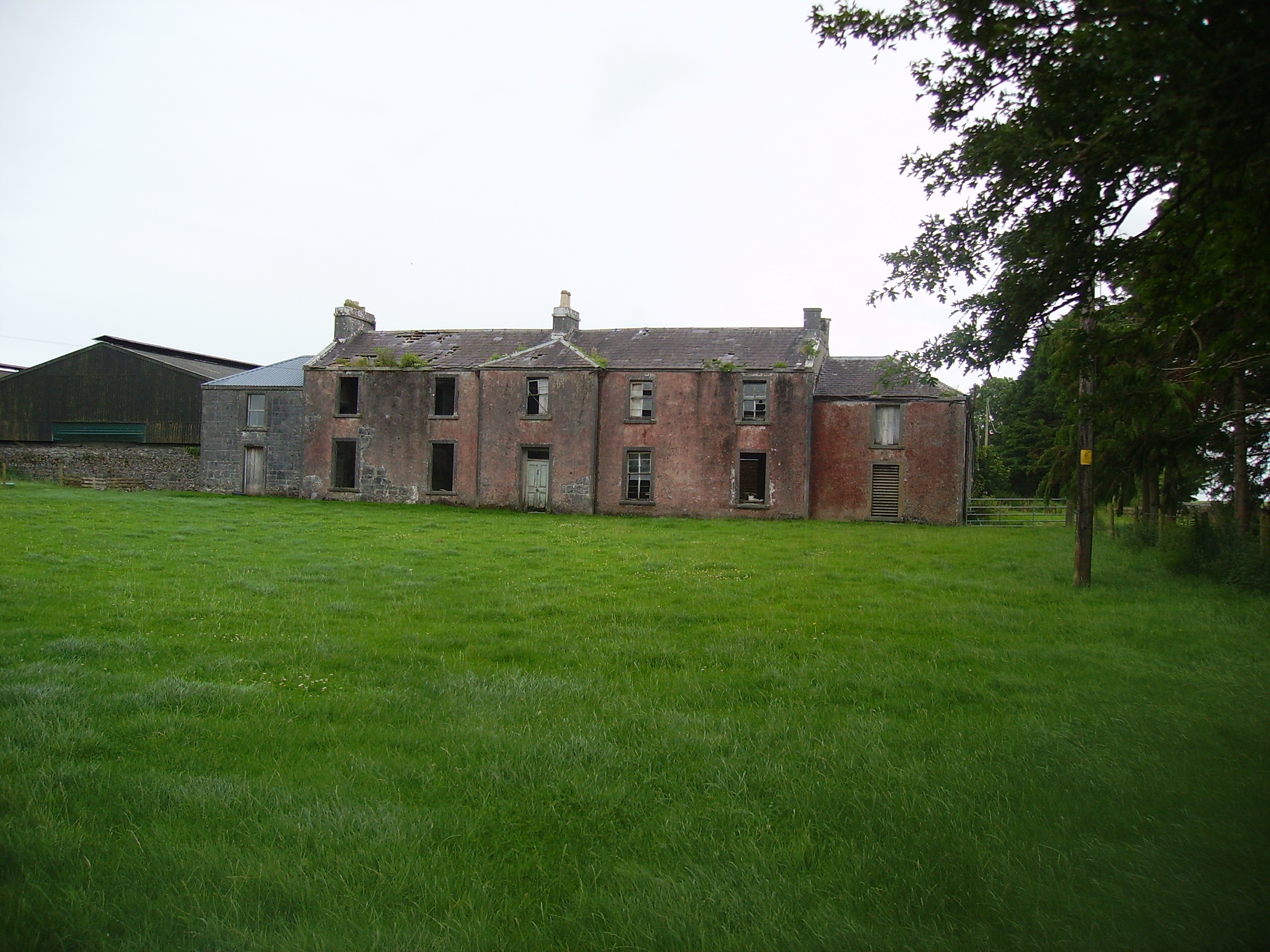
| Kiltybegs | Large complex of buildings marked on the 1st edition 6 inch Ordnance Survey map (1836). This was part of the estate of Major John Leslie who held it in fee. The buildings which included a house were valued at £15. Later the home of Charles J. Leslie (see building return 1901 census) and of the land steward, George McGregor, in 1911. Although not classified as a mansion in 1906, the buildings in Kiltybegs had a rateable valuation of £60. This house is no longer extant. | |
| Kiltybegs | Large complex of buildings marked on the 1st edition 6 inch Ordnance Survey map (1836). This was part of the estate of Major John Leslie who held it in fee. The buildings which included a house were valued at £15. Later the home of Charles J. Leslie (see building return 1901 census) and of the land steward, George McGregor, in 1911. This house is no longer extant. | |
| Kinard | Possibly a Plunkett house at the end of the 18th century. At the time of Griffith's Valuation John Clarke occupied the house which he held from James Somerville, valued at £5. It is labelled Kinard House on both the 1st and 25-inch edition Ordnance Survey maps. A house is still extant at the site. | |
| Kinard Lodge | The Ordnance Survey Name Books record Kinnard Lodge as the property of the Paget family in 1837. It appears that it, like other houses in the area, was used as a summer bathing lodge. At the time of Griffith's Valuation, it was occupied by James Paget and was valued at £9. A second house in the townland was occupied by Henry Simpson, leasing from James Paget, and was valued at £6. Kinard Lodge is still extant and occupied. | |
| Kincora Lodge | A house on the outskirts of Killaloe, Weir writes that it was the home of an O'Brien family in the 1840s. Occupied by Captain Frederick Lowe, Royal Navy, at the time of Griffith's Valuation, who held it from Thomas Macnamara. Captain Lowe married Maria Christina, daughter of Henry Ross-Lewin of Ross Hill in 1847. In the 20th century the house belonged to the Butler-Stoneys for some time. | |
| Kincraigie | ||
| Kincraigie | Willam Burton Leslie was leasing land and out-offices from the Ladies Boyle at the time of Griffith's Valuation. The property is labelled Woodview on the first edition Ordnance Survey map. The property later bacame Kincraigie where he lived with his wife, Jane Florence McCartie, the widow of Horace Townsend. Jane's son, also Horace, owned the house until the early twentieth century. Later the home of the Travers family and now a ruin. | |
| Kincraigie (Woodview) | Woodview was being leased by the Ladies Boyle to William B. Leslie at the time of Griffith's Valuation, when it was valued at £19 15s. Lewis refers to the seat of J. Leslie in Courtmacsherry in 1837. The property later bacame Kincraigie where William lived with his wife, Jane Florence McCartie, the widow of Horace Townsend. Jane's son, also Horace, owned the house until the early twentieth century. Later the home of the Travers family. In the 1940s the Irish Tourist Association Survey refers to it as "once a magnificent mansion formerly the home of the Leslies, now almost deserted". At that time it was owned by a Mr. Barrett. It is now a ruin. | |
| Kincraigy | Lewis refers to Leslie Hill as the seat of J. Beers in 1837. This may be a reference to Kincragy Castle which is associated with the Leslie family. The property, valued at £6, was occupied by John McGinley at the time of Griffiths Valuation in the 1850s, leasing from Francis C. Leslie. It is no longer extant. | |
| Kineigh | Thomas Stoughton was leasing this property, valued at £10 15s, to John Fitzgerald at the time of Griffith's Valuation. In 1840, the Ordnance Survey Field Name Books indicated that it was the residence of Rev. George Hickson but had been built by John Hayes at the end of the eighteenth century. It seems to have become a Fitzgerald property later on. In 1894 Slater referred to it as the seat of John Francis Fitzgerald. The Fitzgerald family continued to reside there until the 1930s. The house is still extant. Adjacent to Kineigh House a site labelled "Donnall O'Sulivan's House (site of)" appears on both the 1st and 25-inch edition Ordnance Survey maps. |
|
| King House | King House was built between 1720-1740 by Sir Henry King. In 1786 Wilson wrote "the Earl of Kingston has a very fine house at Boyle, situated near the ruoins of an ancient abbey". Following a fire in 1788 the King family vacated the house and moved to Rockingham on the shores of Lough Key. King House was used as a military barracks until the 1960s. It is now in the ownership of Roscommon County Council and is open to the public. |
|
| Kingsland | At the time of Griffith's Valuation John Conmee was leasing a property valued at £12 from Viscount Lorton's estate at Kingsland, barony of Frenchpark. He had been in possession of this property since at least 1814. Matthew Conmee also leased a property in the same townland, valued at £6 together with 190 acres, from Lord Lorton's estate. |
|
| Kingston House (Galway) | Richard N. Somerville was the owner of over 70 acres in the county of the town of Galway in the 1870s. He was the owner of Kingston House at the time of Griffith's Valuation, when it was valued at £14 and was unoccupied. By the 1890s it was occupied by a religious order. | |
| Kingston Lodge | Johnston states that Kingston Lodge was a residence of the McLoghry family. McTernan notes that it is a mid to late nineteenth century building, built by Henry McCloghry, son of Thomas McClogry of Carrickcoola. It was being leased by him from the Cooper estate at the time of Griffith's Valuation and valued at almost £4. The house remained in the McCloghry family until the 1940s and is now in a derelict state. | |
| Kingswell House/Sadleirswells | Kingswell was a Lovett property in the 18th and early 19th century.The home of a branch of the Sadlier family in the 19th century, labelled on the 1st edition Ordnance Survey map as Sadleirswells House and on the later 25-inch edition as Kingswell House. In 1840 the Ordnance Survey Name Books record that they were seeking the opinion of the then owner William Sadlier as to the name under which the house should appear. Occupied by Richard Sadlier in 1814, by W. Sadlier in 1837 and held by Richard Sadlier in fee at the time of Griffith's Valuation, when the house was valued at £35. Home of a branch of the Massy family in the second half of the 19th century. The sale rental of January 1854 shows that the house was leased to John Massy on 23 January 1852 by Robert W. R. Sadleir for the life of John Massy or 31 years. This house is now demolished although yard buildings and garden follies remain in existence. |

|
| Kingwilliamstown House | At the time of Griffith's Valuation this house was occupied by Martin Roche who held it from the Commissioners of Woods and Forests. It was valued at £14. It later became the home of Nicholas Dunscombe. A house remains at this site though modern housing development has taken place nearby. | |
| Kinlough | A house on the shore of Lough Corrib, facing Ashford Castle and lived in by Patrick Moran in the 1860s and 1870s, now a ruin. |
|
| Kinlough House (Oakfield House) | Kinlough House was originally known as Oakfield House and was the seat of the Johnston family from the early eighteenth century. It was remodelled in the 1820s by Robert Johnston and renamed Kinlough House. At the time of Griffith's Valuation, Kinlough House was occupied by William Johnston and was valued at £45. In 1906 James Johnston was the owner of the mansion house at Kinlough valued at £43 as well as 220 acres of untenanted demesne land. In 1943 the Irish Tourist Association Survey recorded that the house had been destroyed by fire some 20 years previously but that the gardens were still open to the public. Kinlough House is depicted in a ruined state in the Buildings of Ireland survey. Major new housing development is occuring on the site, adjacent to the walled garden. |
|
| Kinnewry House | Home of Charles Crotty in the second half of the 19th century. The grid reference for this property is approximate. | |
| Kinoith | Occupied by William G. Fitzgerald at the time of Griffith's Valuation, valued at £8 and held from Peter P. Gaskell. Occupied by the William Strangham in the first half of the 20th century. This house is now the home of Tim and Darina Allen of the famous Ballymaloe Cookery School. |
|
| Kinturk | A residence of the Bourke family in the early 19th century, situated beside Kinturk Castle. In 1786 Wilson refers to it as the seat of Mr. Burke. The townland was in the possession of Rev. H.N. Ormsby at the time of Griffith's Valuation. |