Browse Houses
Search Results: Returned 5927 records. Displaying results 3501 – 3600
| House name | Description | |
|---|---|---|
| Kinturk House | Kinturk House, located just south of Castlepollard, is a five-bay three-storey over basement country house, built about 1760, remodelled and extended in 1821 for William Dutton Pollard (1789-1839) by Charles Robert Cockerell (1788-1863). It was valued at £90 in 1906. The house remained in the possession of the Pollard/Pollard Urquhart family until the mid-1930s when it was sold to the Congregation of the Sacred Hearts of Jesus and Mary who, in turn, sold it on to the Midland Health Board in 1971. |

|
| Kippagh Lodge | Mary Long was leasing this property from John Bryan in 1851 when it was valued at £10+. It is still extant. | |
| Knappoge House | Robert Wallace was listing this property from Colonel Henry White’s estate at the time of Griffiths Valuation in the early 1850s, when it was valued at over £10. A house is extant at the site but may not be original. | |
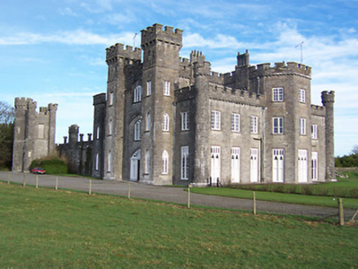
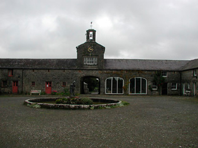
| Knappogue Castle | A Macnamara castle until the early 19th century, it was sold to the Scotts of Cahircon in 1800. In the possession of William Scott by 1837. Lewis writes that the castle formerly belonged to the Macnamaras of Moyriesk and that it "is one of few ancient castles still inhabited". Weir writes that a ten bay residence was added to the tower house in the early 19th century. The sale rental of 1854 records George Sampson as tenant and that £8,000 had recently been spent on the building. By the mid 19th century Lord Dunboyne held the Castle valued at £36 in fee. In the mid 1960s the Castle was developed as a banqueting centre for tourists and continues to function in this role today. http://www.gardensireland.com/knappogue-castle.html |
|
| Knigh Cottage | In 1840 the Ordnance Survey Name Books mention Right Hon. Thomas Lefroy as the proprietor of this house, "a neat cottage, the residence of William Kingsley". He was still the occupier at the time of Griffith's Valuation, when the house was valued at £5. Family history sources suggest that the Kingsley family continued to reside at Knigh Cottage into the early twentieth century when it was acquired by the Harty family. It is still extant. | |
| Knight's Bridge & Glebe | In 1786 Wilson refers to Knight's Bridge as the seat of Sir John Conway Colthurst at Ballyvourney "near the nunnery". This may refer to the ruins of a monastic site dedicated to St. Gobnait. This area was in the possession of Sir George Colthurst at the time of Griffith's Valuation when Rev. Richard Kirchoffer was leasing a property valued at over £20. Buildings are still extant at the site. | |
| Knock House | Knock house is marked on the first edition OS map and named on 25 inch. It is a three-bay two-storey house with a return, built about 1815 and still extant. At the time of Griffith’s Valuation (publ. 1854) the house was occupied by John Robinson who held it from Sir William Leeson. It was valued at £10. |
|
| Knock House (Waterford) | Andrew Ryan was leasing this property from Waterford Corporation in 1850 when it was valued at £18. | |
| Knockaculleen A | At the time of Griffith's Valuation, William Rutledge was leasing a house valued at almost £10 at Knockaculleen, barony of Tireragh, to Catherine Rutledge. [Grid reference is approximate]. | |
| Knockaderry | Knockaderry was the seat of a branch of the Evans family in the 19th century. In 1786 Wilson refers to it as the seat of Mr. D'Arcy. It was occupied by Thomas D'Arcy Evans in 1814. Lewis refers to it as the "ancient seat of the D’Arcy family", the present residence of T.D’Arcy Evans. At the time of Griffith's Valuation it appears to have been in use as an auxillary work house, valued at £35. Knockaderry was held from the Jephson family and a lithograph of the house is included in the Jephson sale rental of 1851. In 1944 the Irish Tourist Association surveyor writes that the house was not well kept and was "rapidly falling to pieces". He also records the house as the birthplace of Mary Lady Heath, an early female pilot. |
|
| Knockaderry House | The National Inventory of Architectural Heritage notes Knockaderry as a mid eigtheenth century house. Maurice Ronayne was leasing this property from Viscount Doneraile's estate at the time of Griffith's Valuation, when it was valued at £17. It had fallen into disrepair by the beginning of the twenty-first century. |

|
| Knockadoo | At the time of Griffith's Valuation the house at Knockadoo was occupied by Meredith Thompson and was valued at £11. McTernan indicates that it had previously been owned by the Savage family and sold to the Thompsons in the 1840s, leaseholders since the eighteenth century. In the 1880s, Knockadoo was sold to the Heather family who ran a horse-breeding business there until the 1930s when the property was acquired by the Land Commission. The house was subsequently damaged by fire but has been extensively restored in recent times. | |
| Knockadoo | Knockadoo was the home of the Knott family in the mid 18th century. Robert Knott was resident there in 1749. Robert Elwood was leasing a house at Knockadoo from Viscount Lorton at the time of Griffith's Valuation. it was valued at £24. In the 1870s it is recorded as the address of Joseph Bennett Little. Earlier, at the time of the first Ordnance Survey it is described as "a fine mansion resided in by Owen Lloyd". A farm is still extant at the site. | |
| Knockadrum | The Burke estate owned a house at Knockadrum, barony of Leitrim at the time of Griffith's Valuation, which was leased to Reverend Lawrence Egan and was valued at £6. In 1906 the buildings at this site were still part of the Burke estate and were valued at over £12. | |
| Knockagallane | This house valued at £10 was in the occupation of Eugene McCarthy at the time of Griffith's Valuation and held from - Morrison. | |
| Knockagh House [Hermitage] | Francis Kenny was leasing this property from the Robinson estate at the time of Griffiths Valuation in the early 1850s, when it was valued at almost £12. On the 1st edition Ordnance Survey map it is labelled Hermitage. The Ordnance Survey Name Books refer to “the gentleman’s seat called Hermitage in this townland”. On the 25-inch edition of the early 20th century it is labelled “Knockagh House – in ruins”. | |
| Knockainy Cottage | Possibly located on the estate of the Earl of Kenmare who owned land in this parish in the mid 19th century. On the first edition Ordnance Survey map this building is named Knockainy Cottage. Later maps show a much larger building now known as Knockainy Stud. |

|
| Knockalass House | At the time of Griffith's Valuation, Patrick Graham was leasing a house at Knockalass, barony of Corran, valued at £5 together with 75 acres from the Gore Booth estate. McTernan notes that the Grahams were initially tenants and later owners in fee. |
|
| Knockanacree Wood House | A house valued at £17+, occupied by Hawtrey Andrews and held from the Reverend Frederick F. Trench in the mid 19th century. Walford states that Hawtrey Andrews was the second son of Maunsell Andrews of Rathanny. This house is now demolished. | |
| Knockane | A Garde home in the early part of the 19th century, Dr T. Garde was resident in 1837. Unoccupied at the time of Griffith's Valuation when valued at £14. Richard and Henry Pratt were then the immediate lessors from the Earl of Shannon. |
|
| Knockane | A house valued at £14.10 shillings in the early 1850s when it was occupied by Henry Ruby and held from Samuel P. Townsend. The original house is no longer extant. | |
| Knockane | Knockane was occupied by Mr William Cooke in 1814. In 1840 the Ordnance Survey Name Books describe it as " a commodious house the property of Mr. Hawkshaw". It was the residence of William Hodgens in the early 1850s, when the buildings were valued at £12.17 shillings and held from Robert Cole Bowen. A possibly later house is located at the site now. | |
| Knockane House | In 1850 Thomas Rockett was leasing a property valued at almost £9 from the Medlicott estate.This house had been constructed after the appearance of the 1st edition Ordnance Survey map in 1840. A second adjacent property was leased by James Rockett and valued at almost £8. There is still an extant house at the site. | |
| Knockane Lodge | Hussey de Burgh cites Knockane Lodge as the address of William H.F. Bosanquet in the 1870s. This may the second house noted in the townland of Knockane at the time of Griffith's Valuation, which was being leased by the Rockett family. | |
| Knockaneacoolteen House | William Curtayne was leasing this house from Lord Kenmare’s estate at the time of Griffith’s Valuation, when it was valued at £4 10s and stood on over 300 acres. Bary indicates that the house, possibly built in the 18th century, is still extant. | |
| Knockaneady | John Beamish was leasing this property to John Schofield at the time of Griffith's Valuation, when it was valued at £6. It does not appear on the later 25-inch Ordnance Survey map of the 1890s. | |
| Knockanglass | This house was the home of James Riall in the early 1850, who held the property from K.Pennefather. The buildings were valued at £18.15 shillings. The National Inventory of Architectural Heritage states that this house was associated with the Langley family and was sold to the O'Dwyers in 1912. It was occupied by Adelaide Langley in 1906. It still functions as a residence. |
|
| Knockanore House | Rev. Thomas Queally was leasing a property at Knockanore valued at £10 10s from the Keily estate in 1851. It is not shown on the 6-inch Ordnance Survey Map but is labelled Knockanore House on the 25-inch map of the 1890s. The property appears to have fallen into disuse during the twentieth century. | |
| Knockanroe | A house valued at £17 at the time of Griffith's Valuation and held by Robert A. Rogers in fee. It is not marked on the first Ordnance Survey map and was probably built in the 1840s. | |
| Knockatrasnane | At the time of Griffith's Valuaiton, William Collis held in fee a house and offices valued at £14.10 shillings in this townland. The 1st edition Ordnance Survey map indicates a nursery at this site. The remains of the buildings are still extant. | |
| Knockaun | The home of the McMahon family located on the Miller estate, they farmed 121 acres as a demesne. The residence of Patrick McMahon in 1814. Lewis records Knockhane as the residence of P. McMahon in 1837. The house was valued at £8 in the mid 19th century. | |
| Knockavelish Cottage | In 1848 Mrs. Anne Blacker was leasing this property from the Carew estate when it was valued at £23 8s. It is labelled Knockavelish Cottage on the 1st edition Ordnance Survey map. It is not named on later maps though buildings still exist at the site. | |
| Knockavinnane Cottage | James Hussey was leasing this property to Alexander Mason at the time of Griffith's Valuation, when it was valued at £15 15s. A portion of the original building is still extant. | |
| Knockbane | Occupied by Anthony O'Flaherty at the time of Griffith's Valuation and valued at £33. The house no longer exists but extensive farm buildings are still visible. The property is still owned by descendents of Anthony O'Flaherty. |
|
| Knockbeha Cottage | A house situated on the Molony estate at the time of Griffith's Valuation. occupied by John McArthur and valued at £16. Weir writes that it was used as a shooting lodge and an R.I.C. barracks. A modern house has been erected on the site. Another house is also marked on the first Ordnance Survey map 1842 at R575 910. | |
| Knockbrack | A house built in the early 1850s by the Hall family and occupied by them until 1922. In 1906 it was valued at £36. The roof of the house was later removed. Only the outline of the basement walls now remain. The farmyard buildings are still used by the Feeney family. |
|
| Knockbrack | At the time of Griffith's Valuation, Joshua Seward was leasing a house valued at almost £10 at Drummaan East, barony of Leitrim. Since 1898 this house has been located in county Clare. This seems to be the house shown on the 1st edition OS map as Knockbrack. A house valued at £14 at Drummaan East, county Clare, was owned by Maj. Gen. Spencer Cooper in 1906. | |
| Knockbrack (Fethard) | In 1786 Wilson mentions Knockbrack as the seat of Mr.Letham. The house at Knockbrack, close to the village of Fethard, is described as "in ruins" on the 1st edition Ordnance Survey map. By the time of Griffith's Valuation, the townland was held in fee by William Barton, when the buildings were valued at almost £3. Farm buildings occupy the site of the old house now. | |
| Knockbrown | A property built after the 1st Ordnance Survey was published. It was held in fee by Thomas B. O'Callaghan in 1851 when it was valued at £8. There is still an extant house at the site. | |
| Knockdrin Castle | A Gothic Revival castle built about 1815; it is not recorded by Leet. Located east of Lough Owel and north of Lough Drin, this castle was built by Sir Richard Levinge (1785-1848) 6th Bt to replace High Park, the Levinges’ old family home and was designed, most probably, by James Shiel. It was valued at £100 in 1906. The Castle remained the home of the Levinge family until the mid-20th century when it was sold. It is now the home of the Prondzyunski family. |
|
| Knockduff House | Rev. Thomas Townsend was leasing Knockduff House to John F. Lee at the time of Griffith's Valuation, when it was valued at £22. Lewis refers to Knockduve as the seat of Lt. Gen. Sir. T. Browne in 1837. It is no longer extant. | |
| Knockeevan/Darling Hill | William Pennefather (died 1819) of Knockeevan was the second son of Richard Pennefather of New Park. Knockeevan became the home of his eldest son, Richard, Baron of the Exchequer, Ireland, who employed William Tinsley as architect in the mid 1820s. The house was originally known as Darling Hill and it belonged to the Carleton family in the 18th century. Wilson refers to it as the seat of Mr. Carleton in 1786. Oliver Carleton sold it to the Pennefathers in 1782. The house was held by the Honourable Baron Pennefather in fee at the time of Griffith's Valuation when it was valued at £54+. It later passed into the possession of Lady Emily Hankey, daughter-in-law of Baron Pennefather and then to the Stanhope family. Sold by the Stanhopes in the late 19th century or early 20th century. This house no longer exists. see http://www.dia.ie/architects/view/5338#tab_works concerning the architect. |
|
| Knockglass | Charles Masters was leasing buildings valued at £14 which included a mill at Knockglass, parish of Kilcloony, barony of Clonmacnowen, from the Ashe estate at the time of Griffith's Valuation. Builidings are still extant at the site. | |
| Knockglass | The main residence of the Paget family in the 19th century. Afterwards it passed into the possession of Patrick Rowe and later served as the home of the Church of Ireland Bishop of Tuam, Achonry and Killala. In 2011 it was offered for sale. |

|
| Knockglass | Edward F. Day was leasing this property to Ursula Rae at the time of Griffith’s Valuation, when it was valued at £11. Lewis refers to it as the home of Mrs. Rae in 1837. Bary states that it later passed by marriage to the McIntosh family but that the house is now ruinous. | |
| Knockglass House/Woodville | Also known as Knockglass House, this residence was situated close to the demesne of Greenwoodpark. At the time of Griffith's Valuation it was leased by John McDonnell from Major Knox when it was valued at £6. It is labelled Knockglass House on the 1st edition Ordnance Survey map but appears to be in ruins by the publication of the 25-inch edition map in the 1890s. | |
| Knockkelly | In the mid 19th century Richard Crane held a house valued at £12+ from William Barton in the townland of Knockkelly. This appears to be the house marked as Knockkelly house on the first edition Ordnance Survey map. | |
| Knocklofty | A mainly 18th century house, cited by Wilson as the seat of John Hely Hutchinson in 1786. In 1840 the Ordnance Survey Name Books describe it as "spacious and handsome, having a fine plain front". It was valued at £70 in the mid 19th century, the seat of the Earls of Donoughmore until 1983, though Walford mentions Samuel H. Goold-Adams of Knocklofty in 1885. The Irish Tourist Association surveyor writes that Knocklofty was De Valera's headquarters for a time during the Civil War. Until recently it served as a hotel but in 2013 it was offered for sale. |

|
| Knockmacool House | Mrs Susan McDonnell [McDaniel] held this property in fee at the time of Griffith's Valuation, when it was valued at £11 10s. It is labelled Desert Cottage on the 1st edition Ordnance Survey map and Knockmacool House on the later 25-inch edition. An Encumbered Estates Sale notice of May 1851 indicates she had previously held it from the Warren estate. A house is still extant at the site. | |
| Knockmartin House | Michael Cody was leasing this property from the Porter estate at the time of Griffiths Valuation in the early 1850s when it was valued at over £12. It is labelled Knockmartin House on the 25-inch OS map of the early 20th century. A later house exists at the site. | |
| Knockmonalea House | A house valued at £14, the home of John Hudson at the time of Griffith's Valuation and held from Lord Ponsonby. | |
| Knockmore | Leased by Thomas Ormsby from Lord Kilmaine at the time of Griffith's Valuation, when the property was valued at £13. The ruins of this house were still extant in the 1980s but the house is now demolished and a modern residence erected on the site. The old farm buildings still remain. |
|
| Knocknacreeve House | A building is marked at this site on the first edition OS map and a building of a different shape named Knocknacreeve House on 25 inch map. Richard Ham occupied this house valued at £14 which he held from Robert Smith, at the time of Griffith’s Valuation (publ. 1854). It is now the centre of a farm complex of buildings. | |
| Knocknagappul House | The representatives of Robert Belcher were leasing this property to Francis Croker at the time of Griffith's Valuation when it was valued at £8 10s. There is still an extant house at this site. |
|
| Knocknagore | A house on the Stacpoole estate built by Edmund Mahony who Weir writes married Mary Stacpoole of the Eden Vale family and still occupied by their descendants in the 20th century. | |
| Knocknagur | Sometimes spelt Cnocnagur. | |
| Knocknaman | Henry Denny was leasing a property valued at £9 to William Thompson at the time of Griffith’s Valuation. An uunamed house, surrounded by trees, is marked on the 1st edition OS map. There is no house at this site now. | |
| Knocknamucklagh House | Charles Daly was leasing this property from the Kenmare estate at the time of Griffith’s Valuation, when it was valued at £5 10s. Bary indicates that this is a very old property, possibly built by the Fitzgeralds in the early 18th century when they were Kenmare’s tenants here. By the middle of the 19th century the Daly family were occupying the property which is still extant. | |
| Knocknanav House | John Hennessy was leasing this property from Richard Creagh and Thomas Leane at the time of Griffith's Valuation, when it was valued at £13. A house is still extant at this site. | |
| Knocknaseed | Christiana Duggan (nee Cronin) was leasing Knocknaseed House from the Kenmare Estate at the time of Griffith's Valuation, when it was valued at £16. Bary states that the current house was built around 1839, replacing an older house on the site. It is still extant. | |
| Knockranny | A house in the town of Westport occupied by the Livingstones. It was valued at £40 at the time of Griffith's Valuation which included the house, offices, gate lodge and another lodge. This may have been the house marked on the first Ordnance Survey map as Westport Lodge. This building now forms part of the Sacred Heart School complex. |
|
| Knockranny | At the time of Griffith's Valuation Knockranny House was leased by Joseph Bennett Little from the Tenison estate and was valued at £25. Lewis recorded the house as the seat of the Dodwell family. Knockranny is still extant but derelict. |
|
| Knockrobin | Mary Anne Bolton held this property in fee at the time of Griffith's Valuation, when it was valued at 17 10s. Lewis records it as the seat of Captain E. Bolton in 1837. A house is still extant at the site. | |
| Knockroe | Knockroe house was part of the Wingfield estate and at the time of Griffith's Valuation was valued at £12. The property is now part of a farm. The remains of the entrance gates are supported by an iron bedpost! | |
| Knocktoran | This late 19th century seat of the Webb family is now a stud farm. Anna Thomasina Webb occupied the house in 1906 when it was valued at £32. Owned by Major S.N.C. Webb in 1943. It is still extant. |
|
| Knockvicar | At the time of Griffith's Valuation Charles J. Peyton was leasing a house at Knockvicar, parish of Ardcarn, valued at £15 to Edward Jones. Lewis records the house as the seat of C.J. Peyton in 1837. In 1814 it was the seat of Randal Peyton. | |
| Kyle | A house occupied by Matthew R. Millett at the time of Griffith's Valuation, valued at £10 and held from Colonel W. Palliser. | |
| Kyle Park | Marked on the first edition Ordnance Survey map Kyle Park was occupied by Thomas G. Stoney at the time of Griffith's Valuation and held by him in fee. It was valued at £39. The Ordnance Survey Name Books had described it as " a new and commodious house built and occupied by T.G. Stoney". The Stoneys still lived at Kyle Park in the 1870s. This house is still extant. |
|
| Kylebrack | In 1906 Lord Clonbrock's estate held a property valued at £3 at Kylebrack West, barony of Leitrim, county Galway as well as over 100 acres of untenanted land. At the time of Griffith's Valuation, the townland was leased to tenants and this property appears to have been occupied by Michael Coleman. | |
| Kylemore Abbey | A very large residence built in the late 1860s for Mitchell Henry with extensive gardens, incorporating the former Kylemore Lodge. Later a home of the Duke and Duchess of Manchester. Now a school and tourist business run by a French order of Benedictine nuns. |
|
| Kylemore Dairy | Allan Pollok held a property valued at £7 together with over 400 acres in the townland of Kylemore, parish of Clonfert, barony of Longford in 1856. On the 25-inch Ordnance survey map of the 1890s there is a property labelled Kylemore Dairy in this townland. Parts of the farm buildings remain at the site. | |
| Kylemore House | Built by the Reverend Joseph Duncan on the shore of Kylemore Lake in the early 1850s and run as a hotel for sportsmen. Occupied by Talbot Clifton in the early 20th century and for a time by St John Gogarty after Renvyle House was burnt in the 1920s. Still run as a guest house by Nancy Naughton. |
|
| Kylemore Lodge | Built circa 1900 possibly as a shooting lodge of the Guinness family, now run as a B & B. |
|
| La Mancha | La Mancha is situated facing Lough Ennell and named on the first edition OS map. This house was occupied by William Wynne in 1814 and was the property of Richard Swift in 1837, who held it in fee and valued at £18 at the time of Griffith’s Valuation (publ. 1854). This house is still extant. |
|
| Lacka | Lewis records W. Cruess as proprietor of Lacka in 1837. On the first edition Ordnance Survey map a small house named Ash Grove is marked in the townland of Lacka S024 979. Later maps mark Lacka House at the crossroads. Griffith's Valuation names William N. Cruise as the occupier of a house valued at £10 in Lacka. He held the property and 335 acres from William Abernethy. The buildings were valued at £10. In the 1870s Samuel R. Cruess of Lacka owned 365 acres and William V. Cruise of Nenagh owned 121 acres. | |
| Lackafinna | A house built in the 1840s close to the shore of Lough Corrib and occupied by Ormsby Elwood, brother in law of Dr Watkins Roberts. The house was renovated in 2004 and is now a family home. | |
| Lackamore Lodge | A late 19th century house valued at £13+ in 1906 and held by the representatives of Robert Heard. This building was located just to the south of a police barrack and is now a ruin. | |
| Lackan | Occupied by James Lyster in 1814 and by Patrick McDonnell at the time of Griffith's Valuation. The house is modernised and still used as a family home. |

|
| Lackan | Lackan house is marked but not named on the first edition OS map. It was a two-storey, three-bay house, the home of the Delamare family, long associated with the Multyfarnham area. The Taylor and Skinner maps of the late 1770s include reference to Delamar at Lacken. In 1837 Lackan was the seat of Mrs Delamere. It was unoccupied at the time of Griffith’s Valuation (publ. 1854) when valued at £17. The immediate lessor was Patrick J Murphy. A number of Delemere families were still resident in the townland in 1901. This house has been demolished. | |
| Lackan Lodge | O’Brien writes of Walter Dillon living at Lackan in 1796. Lackan Lodge, valued at £14, was occupied by William Thomson in the mid-19th century. He held the property from the Dillons minors. A new building has been erected on this site. |
|
| Lackandarra A | Mrs. Eleanor Power was leasing this property from the Chearnley estate at the time of Griffith's Valuation, when it was valued at £9. There are still buildings extant at the site. | |
| Lackandarra Lodge | At the time of Griffith's Valuation, Richard Chearnley held this property in fee when it was valued at almost £10. On the 25-inch Ordnance Survey Map of the 1890s it is labelled Lackandarra Lodge. A farm is still extant at the site. | |
| Lackaroe House | In 1850, Catherine Anne Parker was leasing this property to Cornelius Hawkes when it was valued at £21. A house still exists at this site. | |
| Lackeel | An early 19th century house valued at £12 was held by Charles Daly in the mid 19th century from Pierce Purcell. This house is still extant. |
|
| Lackeen | Lackeen House is an early 18th structure attached to part of a 17th century house. John Baily was the proprietor of Lackeen Castle, Parsonstown [Birr], in 1814 and in the mid 19th century the house valued at £12.10 shillings was occupied by Hamilton English and held from Lord Cremore. This house is now unoccupied. |
|
| Lacken | In 1840 the Ordnance Survey Name Books noted Lacken as the residence of "Pendergrass", a house in very good repair. John Mulcahy occupied the house valued at £15+ at Lacken in the mid 19th century. He held the property from William Ryan. This house is no longer lived in. |

|
| Lacken | John Smithwick was resident at Lacken in 1837 and by George Smithwick in the early 1850s and held from Miss Mary Sadlier. The buildings were valued at £11. A house is still extant at the site. | |
| Lacken Lodge | Leased by Dominick Fallon from the Devonshire estate in 1851 when it was valued at £12 10s. | |
| Lackenacoombe | Samuel Cooper held this house in fee at the time of Griffith's Valuation. It was valued at £7.5 shillings. Some buildings remain at this site. | |
| Lackendarra House | In 1851, Mrs. Eleanor Fitzgerald was leasing this property from Rev. James Elliott when it was valued at £11 5s. In 1894 it appears to have been occupied by a Russell family. | |
| Lackenduff House | Thomas Lucas was the owner of this property, unoccupied at the time of Griffith's Valuation, when it was valued at £15 10s. Lewis refers to Lackenduff House as the seat of J. Lucas in 1837. It is still extant and occupied. |
|
| Lackenshoneen | Benjamin Cross occupied this house in the mid 19th century. He held it from Philip Cross and the buildings were valued at £12. The buildings have all but disappeared on the 25-inch edition Ordnance Survey map of the 1890s and nothing remains at the site now. | |
| Ladestown | Ladestown House, sometimes known as Ladytown or Ladystown, home of the Lyons family, was in existence when the Taylor and Skinner maps were compiled at the end of the 1770s but was rebuilt about 1823 as a five-bay two-storey over basement house. From 1814 to the 1850s, the author John Charles Lyons is recorded as the occupier. At the time of Griffith’s Valuation (publ. 1854) he held the property in fee and the house was valued at £44. The Lyons family continued to live at Ladestown in the early years of the 20th century. The house is now demolished but outbuildings survive which are home to a riding school. |
|
| Ladywell | Although much of the demesne of Harmony Hall is shown in the townland of Bunown on the first edition OS map, the house Ladywell was not built at this time. An elegant Italianate country house, six-bay two-storey over (partial) basement country house on L-shaped plan, built about 1845 to a design by Sandham Symes (1808-1894), for the Mahon Family (boi). In the mid-19th century Ross Mahon was the occupant holding the building valued at £37 in fee. Members of the Metge, Crofton, Williams and Flannery have all been occupants of this house. It has extensive views over Killinure Lough to the south. |
|
| Lagaturrin | The house at Lagaturrin was valued at £6 at the time of Griffith's Valuation, when it was occupied by William Fitzmaurice. William R. Falkiner lived here in the early 1860s. It is no longer extant. | |
| Lagduff Lodge | Used as a barracks for the Revenue Police at the time of Griffith's Valuation when the buildings were valued at £14. It later became a fishing lodge a function it still fulfils. |
|
| Laharan House | Sir William Godfrey was leasing this property to James O'Neill at the time of Griffith's Valuation, when it was valued at £7 5s, and part of a holding of 170 acres. It was recorded as the seat of F. Walker by Lewis in 1837 and Leet in 1814 as the seat of Francis Walker. Bary states that it was built by Francis Walker in 1808. The house passed to the Cronin family in the 1880s. It is stil extant and occupied. | |
| Lahard | Lahard was the home of the Young family in the 18th and 19th centuries. It is named on the first edition six inch Ordnance Survey map (publ. 1837) which shows a flower garden to the south of the house. Occupied by Cosby Young in 1814 and by John Lough in the 1850s, who held the property from the representatives of Cosby Young. The buildings were valued at £10. Inherited by one of Cosby Young’s daughters, Mrs Mackarness. The railway line was erected to the south west of this house. It is no longer extant. | |
| Laheen | In the 1780s both Taylor and Skinner and Wilson recorded Laheen as a seat of the Peyton family. Lewis also records it as a Peyton residence. At the time of Griffith's Valuation it was being leased by Richard Peyton to Michael Fitzgerald and was valued at £15. The original Laheen house is not extant though a house and extensive farm buildings remain at the site. | |
| Laherdan House | In 1850, John Whelan was leasing this property from the Beresford estate when it was valued at £11 10s. It is labelled Laherdan House on the 25-inch Ordnance survey map of the 1890s. A house is still extant at the site. |