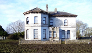
Mossfort
| Estate(s) | |
|---|---|
| Townland | Caherakeeny |
| Civil Parish | Donaghpatrick |
| PLU | Tuam |
| DED | Beaghmore 201 |
| County | Galway |
| Barony | Clare |
| Description | A house labelled Caherakeeny is shown here on the First ediiton Ordnance Survey map. It was valued at £12 and occupied by John Kilkelly at the time of Griffith's Valuation. The present house was constructed in the late nineteenth century and is labelled Mossfort on the 25-inch Ordnance Survey map of the 1890s. |