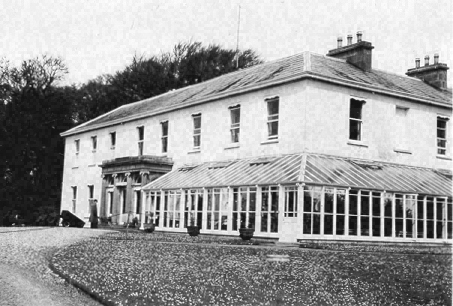
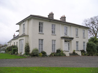
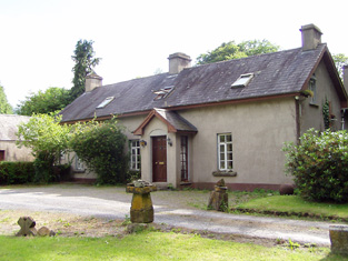
Riversdale
Houses within 15km of this house
Displaying 56 houses.
Houses within 15km of Riversdale
Displaying 56 houses.
| House name | Description | |
|---|---|---|
| Kilfrush | The home of Joseph Gubbins from at least 1837 and held in the early 1850s from the Court of Chancery. It was valued at £70 and was still the home of the Gubbins in the 1870s and in 1906 when it was valued at almost £66. According to the Irish Tourist Association survey it had been built in 1825 and was still the home of Mrs Gubbins in 1943. It is still extant. |
|
| Newtown House | In 1786 Wilson refers to Newtown as the seat of Mr. Ellard. Occupied by Miles Ryan in 1814 and by Richard Ellard at the time of Griffith's Valuation. Ellard held the property from - Keating and the buildings were valued at £13. Lewis refers to Newtown Ellard as the ancient seat of the Lloyd family. In 1906 this house valued at £23.10 shillings was occupied by Mary R. Ellard. It is still extant. |
|
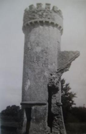
| Castle Lloyd | The seat of the Lloyd family in the 19th century, the sale rental of 1855 records that the original lease was from Robert Bradshaw to the Reverend Richard Lloyd, 8 Nov 1760. IN 1786 Wilson refers to Castle Lloyd as the seat of Rev. Mr. Lloyd. It was occupied by the Reverend Michael Foster in 1814 and by Thomas Lloyd in 1837. Although described by Lewis in 1837 as the handsome residence of Thomas Lloyd, the Ordnance Survey Field Name Book states that the house was in a neglected and decayed state in 1840 due to the death of "the Captain this year". By the time of Griffith's Valuation the house was leased to the Guardians of the Tipperary Union who were using it as a Workhouse. The buildings were valued at £44. Castle Lloyd was advertised for sale in November 1881 on 93 acres. It belonged to Patrick Daly who held it under a fee farm grant dated 12 July 1869 from Letitia Anne Bradshaw to William Daly. The Irish Tourist Association Survey of the early 1940s refers to the demolition of this house about 70 years previously and that only the circular tower remained of the extensive 18th century dwelling built by Captain Lloyd. |
|
| Ahnagurra | Ahnagurra was the residence of Thomas T. Adams in 1837 and at the time of Griffith's Valuation, when the buildings were valued at £26. He held the property from Francis Coppinger. | |
| Ballynalacken | A house valued at £15 and occupied by George Gubbins who held it from Francis Coppinger at the time of Griffith's Valuation. It is no longer extant. | |
| Griston House | The residence of a branch of the Massy family, occupied by Frederick Massy in 1814. Described by Lewis in 1837 as the fine old family mansion of the Masseys. Fitzgerald writes that Charles Massy of Griston was a brother of Lord Massy and 1st Lord Clarina. At the time of Griffith's Valuation it was valued at £12 and occupied by Michael McMahon, who held it from Charles O'Brien Massy. | |
| Ryves Castle [Castle Jane] | Ryves Castle, previously known as Castle Jane, was the home of the family of this name in the 18th and early 19th centuries. It is referred to as Castle Jane by Wilson in 1786 when he notes it as the seat of Mr. Ryves. By the 1830s however William H. Ryves of Ryves Castle appears to have moved to live in Brighton, as the birth of many of his children is recorded in the Limerick newspapers as having taken place there. In 1826 Fitzgerald records Ryves Castle as the residence of John Lowe. Lewis referring to the parish of Knocklong, notes that Thaddeus R. Ryan was resident at Castle Jane and that there was a vault of the Lowe family located in the grounds of Ryves Castle, that family having previously been its proprietors. For the parish of Ballyscanlan he records Ryves Castle as the residence of P. [T?] Ryan. At the time of Griffith's Valuation the house was valued at £29 and occupied and held in fee by William H. Ryves. In 1906 it was valued at £31 and was occupied by Thomas J. Franks. Later owned by Mr D. Fleming, this house is now demolished. | |
| Scarteen | Thaddeus R. Ryan was resident at nearby Castle Jane [Ryves Castle] in 1837 as recorded by Lewis and Scarteen was unoccupied. John Ryan was the occupier of Scarteen in the early 1850s when the house was valued at £30+. He held the property from William H. Ryves. His widow Alice owned 50 acres in county Limerick in the 1870s. The Ryans still live at Scarteen where the famous pack of hounds of that name is kennelled. |

|
| Massy Lodge | This house is named Massy House on the first Ordnance Survey map and was the main residence of Lord Massy in the first decade of the 19th century. In 1814 Anglesborough was occupied by Hugh Toutstone [Touchstone]. Lewis describes Massy Lodge as the elegant residence of Lord Massy. At the time of the first Ordnance Survey Massy Lodge was the residence of Robert Harding. It was held by Lord Massy in fee at the time of Griffith's Valuation and valued at £24+. The partly demolished house is now owned by the Hanly family. |

|
| Janeville | A house located very close to the county Tipperary border, occupied by the Reverend R. Lloyd in 1837 and by Samuel R. Harding at the time of Griffith's Valuation. The buildings were valued at £17+ and held from Thomas L. Sadlier. | |
| Glenefy/Gleneefy | Built for George L. Bennett by Charles Frederick Anderson see http://www.dia.ie/works/view/256 The house is named on the first Ordnance Survey map as Gleneefy but on the later 25-inch map as Glenefy. In 1837 Castlecreagh was the residence of G. Bennett and at the time of Griffith's Valuation Castlecreagh, valued at £26 was held by George L. Bennett in fee. In 1906 occupied by William H.M. Bennett and still valued at £26. It is still extant. |
|
| Stagdale Lodge | A Massy house occupied by members of the Massy family from the late 18th century. It was the home of Hugh Massy, a younger brother of George Massy of Glenwilliam Castle, at the beginning of the 19th century. Held by W. Massy in 1837, Lewis records the "fine avenue of stately beech trees". William Massy was still resident at the time of Grifffith's Valuation holding the property from Hugh Massy. In 1906 occupied by Hugh H.G. Massy and valued at £30.10 shillings. | |
| Loughananna | At the time of Griffith's Valuation a house at Loughananna was occupied by James McGrath, valued at £10+ and situated on the Kingston estate. By 1906 the mansion house at Loughananna was valued at £50+ and Abel Buckley is recorded as the occupier. | |
| Ballynahinch | A house valued at £11 occupied by Thomas Cleary at the time of Griffith's Valuation and held with 354 acres from the Trench/Gascoigne estate. Thomas Cleary of Ballinahinch owned 454 acres in county Limerick in the 1870s. A house is still extant at the site. | |
| Ballywire | The demesne of this house straddled the border between counties Limerick and Tipperary. In 1826 Fitzgerald refers to the house having been "lately fitted up and furnished in a very tasteful manner". Godfrey Massey was resident at Ballywire in 1814. By 1837 it had become the home of John Bolton Massy who held the property in the 1850s from the Provost and Fellows of Trinity College, Dublin. It was valued at £40. This house is still a residence. |

|
| Bansha Castle | The home of the O'Brien Butlers in the 18th century. In 1786 Wilson refers to Bansha as the seat of Mr.O'Brien. The residence of the O'Ryan family in the first half of the 19th century, occupied by Andrew O'Ryan in 1814 and Edmund O'Ryan in 1837. John Chaytor was resident fromn 1840 and into the early 1850s holding the buildings valued at £25 from Edmund O'Ryan. This property was advertised for sale in the early 1860s. The rental of 1866 describes this residence as containing " Four spacious reception rooms, six well ventilated bed rooms, bath room and servant's dormitory". In the 1870s Major John Lutman of Bansha Castle, who was married to an O'Ryan, owned 485 acres in county Tipperary and 94 acres in county Limerick. Bansha Castle was the home of Sir William Francis Butler in the early 20th century. The Russell family now offer luxury accommodation at Bansha Castle. see http://www.banshacastle.com/index.html |

|
| Garryspillane House | A mansion house valued at £16.15 shillings was located in this townland in 1906. It was occupied by Stafford Delmege, second son of the Reverend John Delmege, whose representatives owned 525 acres in county Limerick in the 1870s. A house labelled Garryspillane House is shown on the 25-inch Ordnance Survey Map of the 1890s. There is still an extant house at the site. | |
| Lismacue | The seat of the Baker family in the 18th and 19th centuries, Lismacue was referred to by Wilson as the seat of Mr. Baker in 1786. It was occupied by William Baker in 1814 and by his nephew, Hugh Baker in 1837 when Lewis describes the house as a "handsome castellated mansion". The Ordnance Survey Name Books describe it as "lately erected...the property of John Charters" in 1840. The house was valued at £55 at the time of Griffith's Valuation. This property is still in the possession of a family member and may be rented for country vacations. http://www.lismacue.com/index.htm |

|
| Ballynacourty | Originally the home of the Dawson family, it passed by marriage to the Massy family and was the seat of the Massy Dawsons in the 18th and 19th centuries. Occupied by J. H. Massy Dawson in 1837 and owned by the estate of Reverend John M. Dawson in the early 1850s. It was held in fee and was valued at £75. In 1839 the Ordnance Survey Name Books describe it as "beautifully situated and in good repair, the residence of Rev. J.M. Dawson". In 1894 Slater refers to it as the seat of George Staunton King Massy-Dawson. This house was a ruin by the mid 20th century. |

|
| Galtee Castle | Built in the late 18th century as a hunting lodge, it was described in the Kingston sale rental of July 1851 as a "handsome cut stone building, erected in a tasteful style of architecture, with suitable offices .... beautifully situated in the curve of a well planted glen..". Located close to the eastern bank of the Attychraan River at the base of the southern slope of the Galty Mountains, this house was occupied by James Law in the mid 19th century, valued at £29+ and held by him in fee. Noted by Slater in 1894 as the home of Nathaniel Buckley and of Abel Buckley in 1906 when the buildings were valued at £130. The house is no longer extant. Also known as Mountain Lodge. | |
| Mount Bruis | The Inventory of Irish Architectural Heritage dates this house from the mid 18th century. It was occupied by Doherty Esq in the 1770s and in 1786. The residence of Edmund Scully in 1814, Mrs Doherty in 1837 and Thomas Dwyer in the early 1850s. Dwyer held the property from Irwing Bagnell and the buildings were valued at £25. In 1840 the Ordnance Survey Name Books described it as "a very old building and in middling repair". It is still extant. |

|
| Woodville | Lewis records Matthew Gibbons [Givens?] as the occupier of this house. Mathew Givens was resident at the time of Griffith's Valuation and held the house valued at £15 from the estate of Reverend John M. Dawson. In 1839 the Ordnance Survey Name Books describe it as "in excellent repair and beautifully ornamented". It is still extant and occupied. |

|
| Ballyglass House (Clanwilliam) | Lewis records Mrs Slattery as resident at Ballyglass in 1837. In 1840 The Ordnance Survey Name Books refer to it as a house "in good repair, the residence of John Burke". It is recorded under both Clonpet and Cordangan parishes. By the mid 19th century it was the home of Thomas Mulcahy. The house was valued at £18.10 shillings and was held from Robert Maxwell. Buildings still exist at this location. | |
| Brookville | In 1840, the Ordnance Survey Name Books describe Brookville as "of very large dimensions, in very good repair, the residence of James Sadlier". He still lived at Brookville in the mid 19th century when the house was valued at £30 and held from James H. Smith Barry. This house, located on the south side of Tipperary town, is still a residence. |

|
| Cordangan House | Cordangan was a Cooke family residence in the 18th and 19th centuries, occupied by John Cooke in 1814. The Ordnance Survey Name Books refer to it as being "in very good repair, the residence of J. Cooke". in the early 1850s it was occupied by Thomas Cooke. The property was held from the Smith Barry estate and the buildings were valued at £26. Slater refers to it as the residence of Horatio Townsend in 1894. In 1906 it was in the possession of Lord Barrymore and valued at £53. It is still extant. |

|
| Scalaheen | In 1840 the Ordnance Survey Name Books describe Scalaheen as "a very large house pleasantly situated on a hill, the residence of Richard Sadlier". William Sadlier occupied this house which he held from Nicholas Sadlier at the time of Griffith's Valuation. It was valued at £30. This house, which was located on the outskirts of Tipperary town, no longer exists. | |
| Ballynacree House | A house valued at £10 and held from Samuel Dixon by Michael Manning in the mid 19th century. Ballynacree is still extant. |

|
| Pegsborough House | In 1786 Wilson refers to Pegsborough as a seat of the Earl of Derby. Henry Smithwick was living at Pegsborough in 1814. By 1837 George Bradshaw was resident. The Ordnance Survey Name Books in 1840 refer to this house as the property of Lord Portarlington. In the early 1850s George Bradshaw held the property from Henry Smithwick. The buildings were valued at £23.5 shillings. A house is still extant at the site. | |
| Bansha House | Bansha House is marked on the first edition Ordnance Survey Map circa 1840. It was the home of Robert Clarke, fourth son of the Reverend Marshal Clarke, in 1837. John Vincent occupied a house valued at £20 in this townland at the time of Griffith's Valuation. He held it from Richard Butler. The National Inventory of Architectural Heritage dates this house from about 1880. It now functions as a guest house. http://www.tipp.ie/banshahs.htm |

|
| Kilfeakle | A home of the Bunbury family in the mid 18th century and later of the Scully family. James Scully was resident at Kilfeacle in 1814. Mrs Scully, [widow of Denys Scully, son of James], was the occupier in 1837 and her fourth son Thomas was resident at the time of Griffith's Valuation. He held the property from the representatives of B. Bunbury. By the early 20th century Kilfeakle House was in ruins. | |
| Kilshane/Arraghslea | Kilshane Cottage was occupied by Captain Blackmore in 1837 and noted by the Ordnance Survey Name Books as "the residence of Captain Blackmore, in excellent repair" in 1840. It was occupied by Henry Blackmore in the mid 19th century, when the house was valued at £11 and held from Simon Lowe. The Blackmores were related to the Lowes. This building is named Kilshane on the first edition Ordnance Survey map. Buildings in Kilshane valued at £12 were still in the possession of the Lowe family in 1906. This house later became known as Arraghslea and following a townland boundary change was located in the townland of Springhouse. |

|
| Kilshane/ Spring House | It is not clear where the McCarthy house at Springhouse was located but a building is marked on the first edition Ordnance Survey map as Spring House, later known as Kilshane. In 1786 Wilson refers to Spring House as the seat of Mr. McCathy. Thomas McCarthy resided at Springhouse in 1814. The present house was built in the 1820s by John Lowe and was designed by C. F. Anderson. It continued to be the home of the Lowe family throughout the 19th century. Lewis refers to Spring House the residence of J. Low. Simon Low held the property in fee at the time of Griffith's Valuation when the house was valued at £75. The Lowes were still resident in 1906. This house was renovated and restored in the early 21st century and now functions as a hotel. see http://www.kilshanehouse.ie/Contact.html |

|
| Mooresfort | The home of the Crosbie Moore family in the 18th and early 19th century, Wilson refers to Moore's-fort as "the handsome seat of Edward Moore" in 1786. Lewis records Maurice Crosbie Moore as resident in 1837. At the time of Griffith's Valuation Edward C. Moore was still in possession of Mooresfort. However it was advertised for sale in 1852 and sold to Charles Moore of county Antrim, who altered and remodelled the house, reducing it from a 3 storey to a 2 storey house. The house remained in the possession of this family into the 20th century. It is now the main residence on a working farm. |

|
| Ballinard | This house was the seat of the Chadwick family in the 18th and 19th centuries. The present house dates from the early 19th century and incorporates parts of an older building. John Chadwick was resident in 1814 and William Chadwick in 1837. In 1840 the Ordnance Survey Name Books note it as the seat of Ostin [Austin] Sadlier and describe the house as "a very large building in good repair". At the time of Griffith's Valuation. the house was valued at £33 and held from the Earl of Portarlington. The Chadwicks were still living at Ballinard at the beginning of the 20th century. |

|
| Damerville | Austin Cooper Chadwick, third son of John C. Chadwick, lived at Damerville in the 1830s. In 1840 the Ordnance Survey Name Books describe it as "a modern structure in good repair". By the time of Griffith's Valuation [his widow] Mrs Anne Chadwick was resident. The house was valued at £10 and held from the Earl of Portarlington. It is still extant. |

|
| Shrone Hill | Shrone Hill or Shronell House is a mid 18th century house. In 1786 Wilson describes it as "once a magnificent building of the late Mr. Damer, now belonging to Lord Milton and in ruins". It was occupied by the Sadlier family in the 18th and 19th centuries. The Ordnance Survey Name Books refer to it as the residence of William Sadlier in 1840. At the time of Griffith's Valution the house was valued at £20 and leased by Clement Sadlier from the Earl of Portarlington. It is still extant. |

|
| Damer's Court | In 1837 Lewis refers to this house as follows "built about a century ago by John Damer, passed to the Earl of Dorchester and then to Lady Caroline Damer his daughter and sole heir and is now the property of the Earl of Portarlington. The mansion was taken down in 1776". It is marked on Taylor and Skinner's map. In 1786 Wilson refers to it as "the very noble and beautiful seat of Lord Milton", On the 1st edition Ordnance Survey map it is labelled "Damerville Court [in ruins]". There is no trace of this house now. | |
| Ballykisteen House | Described by Lewis in 1837 as an "elegant modern building" situated on the Limerick road. The Ordnance Survey Name Books of 1840 refer to it as "the residence of Lord Stanley, pleasantly situated on rising ground and in good repair". In the early 1850s the house was valued at £50 and held in fee by Lord Stanley. It was later one of the homes of the O'Connor family. The original house no longer exists. Ballykisteen hotel and golfcourse are now located near the site. |

|
| Russelstown | At the time of Griffith's Valuation John Hewston occupied Russelstown House, valued at £20, and held from Lord Stanley. |

|
| Barnlough | This house was a Smithwick family home in the 18th and early part of the 19th centuries, occupied by Thomas Smythwick in 1814 and by P. Smithwick in 1837. Barnlough was held by the Earl of Portarlington in fee at the time of Griffith's Valuation, when the buildings were valued at £11.10 shillings. It is no longer extant. | |
| Ashgrove | In 1786 Wilson refers to Ashgrove as the seat of Mr. Ash. At the time of Griffith's Valuation Ashgrove House was valued at £14.10 shillings and occupied by John Henry Ashe who held it from his brother Trevor Lloyd Ashe. A lithograph of Ashgrove is included in the Ashe sale rental of 1854. It was bought by Charles Moore of Mooresfort. Ashgrove was offered for sale again in 1864. It was held on a lease dated 1815 from Trevor Lloyd Ashe to Southwell Moore for 3 lives renewable for ever. Lyons writes that Southwell Mulcahy was resident from 1858. This house is still in use as a residence. |

|
| Castle Mary | Lewis describes Ashgrove Castle or Castle Mary, the residence of the Reverend Trevor Lloyd Ashe, Lord of the Manor of Bansha, as a "castellated mansion in the Italian style of architecture, situated at the base of the Galtee mountains, 4,000 acres of which are attached to the estate". This house is marked on the first edition Ordnance Survey map. In 1840 the Ordnance Survey Name Books refer to it as the property of T.L. Ashe "of modern construction but in very bad repair". It is recorded as "in ruins" in the later 25 inch map of the 1890s. Land clearance has taken place in the area and nothing remains of Castle Mary. | |
| Ballydavid | G. Baker was resident at Ballydavid in 1837 and in the early 1850s when the house was valued at £13.10 shillings and held from the Reverend George Cole Baker. In 1786 Wilson refers to Ballydavid as the seat of Mr. Baker. In 1840 the Ordnance Survey Name Books had noted that the house was in bad repair though the demesne was described as "neatly ornamented". This house no longer exists. | |
| Greenane | The Manserghs were residing at Greenane from the mid 18th century. Wilson, writing in 1786, refers to the house as the seat of Nicholas S Mansergh. In 1814 John Mansergh was the occupant and in 1837 it was the home of his son, Richard Southcote Mansergh. In the mid 19th century the house was valued at £35 and held from Lady Osborne. In 1894 Slater refers to it as the seat of Lt. Col. M. Tynte. The house is still occupied by a member of the Mansergh family, Philippa Mansergh, and her husband, John Wallace. |

|
| Roesborough | Occupied in the 1770s by Sadler Esq. In 1786 Wilson states that it was the seat of James Roe. Occupied in 1814 and 1837 by James Roe and in the early 1850s by his son George who held the property in fee. The house was valued at £32.15 shillings. The representatives of Richard Sadlier were the tenants of Roesborough in 1873. This house is now a ruin. |

|
| Kingswell House/Sadleirswells | Kingswell was a Lovett property in the 18th and early 19th century.The home of a branch of the Sadlier family in the 19th century, labelled on the 1st edition Ordnance Survey map as Sadleirswells House and on the later 25-inch edition as Kingswell House. In 1840 the Ordnance Survey Name Books record that they were seeking the opinion of the then owner William Sadlier as to the name under which the house should appear. Occupied by Richard Sadlier in 1814, by W. Sadlier in 1837 and held by Richard Sadlier in fee at the time of Griffith's Valuation, when the house was valued at £35. Home of a branch of the Massy family in the second half of the 19th century. The sale rental of January 1854 shows that the house was leased to John Massy on 23 January 1852 by Robert W. R. Sadleir for the life of John Massy or 31 years. This house is now demolished although yard buildings and garden follies remain in existence. |

|
| Aherlow Castle | This early 19th century building was the residence of James A. Butler in the 1830s. In 1840 the Ordnance Survey Name Books note that it was the residence of the parish priest of Templeneiry. The Reverend William Kane was resident in the early 1850s when the buildings were valued at £9.15 shillings and held from James A. Butler. Aherlow Castle was later the property of the Moores of Mooresfort. Count Charles Moore was the occupier in 1906 when the buildings were valued at £20. It is now a ruin. |

|
| Glenbrook Cottage | Thomas Holmes was leasing this property from the Massy-Dawson estate at the time of Griffith's Valuation when it was valued at almost £4. It is not named on the 1st edition Ordnance Survey map but appears as Glenbrook Cottage on the 25-inch edition of the 1890s. It is still extant and occupied. Local sources suggest that the original house dates to the seventeenth century and that the Holmes family called it Clydeingrove. |
|
| Rathneaveen | No house is named on the first edition Ordnance Survey map for this townland, however later maps show Rathneaveen House. It was built in the mid 19th century as Michael Ryan occupied a house valued at £10.15 shillings in this townland at the time of Griffith's Valuation. Michael Ryan of Rathneaveen is recorded in the 1870s and the house is still extant. | |
| Cluen House | An 18th century house originally known as Mount Kennedy. This house valued at £15 was being used as an auxiliary workhouse in the mid 19th century. It was held by John Kennedy from Thomas Slattery. In 1906 Lord Barrymore is recorded as the occupier and the building were valued at £28+. |

|
| Friarsfield | A house built circa 1870 for the Manserghs and shown on the 25-inch Ordnance Survey map of the 1890s. It is now occupied by Dr Martin Mansergh and family. In 1840 the Ordnance Survey Name Books refer to another house in this townland, occupied by James Southcote Mansergh and known as Newtown Cottage [R906377]. At the time of Griffith's Valuation, a property in this townland owned by Southcote Mansergh and valued at £40 was in use as an auxiliary workhouse. |

|
| Mountain Lodge | In the mid 19th century Viscount Lismore owned a house/hunting lodge valued at £7 in the townland of Cullenagh (2,740 acres) which he also owned. This building has since been extended and is still in use as a youth hostel. |

|
| Springfield House (Tipperary) | In 1786 Wilson refers to Springfield as the seat of Mr. English. By the time of Griffith's Valuation, the townland was part of the Smith-Barry estate and the house was valued at almost £4. It was occupied by Nicholas Sadlier at the time. A subtantial farm occupies the site now. | |
| Cappagh (Clanwilliam) | In 1786 Wilson refers to Cappagh as the seat of Mr. Massey. At the time of Griffith's Valuation, this townland was the property of estate of Reverend John Massey Dawson. [Grid Reference is approximate]. | |
| Sandymount (Cordangan) | In 1840 the Ordnance Survey Name Books refer to Sandymount House "in good repair", part of the estate of James Sadlier. By the time of Griffith's Valuation, it was being leased by F.J. Mansergh from the Smith-Barry estate and valued at £7 5s. Buildings are still extant at the site. | |
| Ballynilard Cottage | In 1840 the Ordnance Survey Name Books refer to Ballynilard Cottage as the residence of Robert Smithwick, "pleasantly situated and in good repair". At the time of Griffith's Valuation, the townland was part of the Smith-Barry estate. Robert Smithwick was leasing a house valued almost £10 while William Evans, MD, was leasing another house in the townland valued at £10 5s. Ballynilard Cottage is labelled Cottage on the later 25-inch map of the 1890s and a house still exists at that location. |