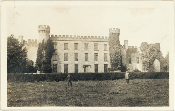
Loughgur Castle
Houses within 15km of this house
Displaying 123 houses.
Houses within 15km of Loughgur Castle
Displaying 123 houses.
| House name | Description | |
|---|---|---|
| Maryville | Built in 1790 and located on the Monsell estate the residence of Hugh F. Finch in 1837 and of Mrs Finch at the time of Griffith's Valuation when the buildings were valued at £28. In 1906 Captain G.W. Finch occupied the mansion house at Maryville valued at £35. Still in the ownership of the Finch family at the time of the Irish Tourist Association survey 1943. This property is now known as Maryville stud. |

|
| Ballymurphy | Occupied by Eyre Powell in 1837 and by the Reverend George Peacock in the early 1850s and held from Edward C. Villiers. |
|
| Fort Etna | The home of the Peacock family in the 19th century, although J. Waller O'Grady was resident in 1837. At the time of Griffith's Valuation it was occupied by Mrs Peacocke who held it from Charles Leslie, valued at £30. Occupied by Edmund White in the 1870s Bence Jones records that it later became the home of the Reilly and Peart families. The original house is now a ruin. | |
| Greenmount | Built in 1770, a two storey house, home of the Green family and held from the Peacockes. In 1786 Wilson refers to the seat of Mr. Greene, within half a mile of Patrickswell. which he calls Graig. The buildings were valued at £42 at the time of Griffith's Valuation. Sold by the Greens in 1947. In the 1960s the house was demolished and a large modern house built instead by the Earl of Harrington. |

|
| Jockeyhall | A Blackall residence in the 18th century, by the mid 19th century Jockeyhall was on the Tuthill estate and occupied by Patrick Dundon. This house was included in the sale of the Tomkins estate in 1861 when held by the representatives of George Tuthill. |
|
| Richmond Villa | This house valued at £16 in the mid 19th century was occupied by the Westropp family from at least 1814, although a Mrs Wallace was in residence in 1837. The Reverend Fitzgerald records a Mr William Wallace as resident in the 1820s and that the house was built about 70 years previously. It was situated on the Tomkins estate. | |
| Duane Ville | The residence of Alexander O'Grady Rose, held by him in fee at the time of Griffith's Valuation when it was valued at £7. It is no longer extant. | |
| Bettyville | Occupied by John Lee in 1814 and held by his son William Norris Lee in fee at the time of Griffith's Valuation and valued at £11+. Fitzgerald describes Bettyville in the 1820s as a 'handsome thatched cottage' occupied by Captain John Franklin. This house was the home of the Revrend John T.N. Lee and valued at £13 in 1906. | |
| Attyflin | A mid 18th century house, Wilson refers to Atthyflin as the seat of the Westropps in 1786. The house was occupied by Hamilton Jackson at the time of Griffith's Valuation and held from John Westropp. The buildings were valued at £50. In 1943 this house was owned by Mrs A. White, nee Massy Westropp and its contents at this time are described by the Irish Tourist Association surveyor. Home of a branch of the Hewson family in the 20th century. It is still extant. |

|
| Ballyclogh | The home of a branch of the Morony family during the 19th century. Occupied by James Todd in the early 1850s who held the property valued at £38 from the Moronys. An occupied house is still located at this site. |

|
| Ballyclogh Lodge | Ballyclogh House and Lodge are both marked on the first Ordnance Survey map of county Limerick. At the time of Griffith's Valuation John Russell held land in the townland with associated buildings valued at £12 from Michael Furnell. There were also mills in the townland valued at £35. Valued at £10+ in 1906 when occupied by George Furnell, Ballyclogh remained in the possession of the Furnell family until 1973. | |
| Derryknockane | George Gloster held this house in fee at the time of Griffith's Valuation when the buildings were valued at £20. | |
| Greenhills | Occupied by Thomas Sherlock in 1814 and by Peter Franklin who held the house valued at £10 and 177 acres from Jeremiah Tuthill, scond son of John Tuthill Villiers. A house is still extant at the site. | |
| Lemonfield House | Sometimes spelt Leamonfield, this house was the home of a junior branch of the Bevan family in the first half of the 19th century. Griffith's Valuation records Thomas Bevan as the occupier holding the property from the Reverend William Lloyd. It was valued at £14. ''Burke's Irish Family Records'' refers to Arthur Russell of Lemonfield, sixth son of John Norris Russell of Limerick. He died 1890. The house is no longer extant. | |
| Linfield | This house was the residence of Darby O'Grady in 1837 and the early 1850s. He held it from the Lloyd Apjohn family who subsequently lived in it. Sold by the Lloyd Apjohns following the death of Michael Marshall Lloyd Apjohn in 1895. This house was a ruin until recently renovated and is now inhabited. |

|
| Fort Elizabeth | Occupied by John Cripps in 1814 and the residence of the Reverend John Croker in 1837. William Croker was the occupier at the time of Griffith's Valuation when it was held from the representatives of James O'Sullivan and valued at almost £16. A substantial farm remains at the site. | |
| Monaster House | This house was the home of Michael Furnell in 1803. By 1814 the house on the Vandeleur estate, was leased to John Cantillon Heffernan . At the time of Griffith's Valuation, the buildings at Monaster were valued at £35 and leased by John Cantillon from the Vandeleur estate. In 1943 the Irish Tourist Association surveyor refers to a story concerning ghostly activities and that the house had been "pulled down" a short time previously. Much of the farmyard building complex survives. |
|
| Ballycummin | Roche Castle was a residence of Sir David Roche at the time of Griffith's Valuation held from the Bishop of Limerick and valued at £30. | |
| Cloghacloka | A house valued at £12, in the possession of the representatives of Pat D'Arcy and held from the representatives of Major Peacock, at the time of Griffith's Valuation. Some farm buildings are still extant at the site. | |
| Rockfield | Situated on the estate of Edward C. Villiers, this house was the home of a branch of the Blennerhassett family in the mid 19th century. It was named Rock View on the first Ordnance Survey map. The Ordnance Survey Field Name Book refers to Rockview as a "plain thatched cottage built in 1819". On the later 25-inch map the house is labelled "Rockfield House". Slater, in 1894, refers to it as the seat of R.B. Blennerhassett. In 1906 Rockfield was described as a mansion house and valued at £22. It was occupied by Richard A. Blennerhassett. A house is still extant at the site. | |
| Cahercorney | Not named on the the 1st edition Ordnance Survey map, this house was the residence of Henry Croker at the time of Griffith's Valuation. It was valued at £10+ and was held from John Croker. Earlier, in 1786, Wilson refers to it as the seat of Mr. White. A farm is extant at this site now. | |
| Fedamore | A house known as Fedamore Cottage is marked on the first Ordnance Survey map. By the early 1850s John and Edward Synan were the occupiers of a house valued at £27 in Fedamore townland, which they held from Colonel Wyndham. The property is shown as Fedamore House on the 25-inch map of the 1890s, by which time it was the residence of J.G. Kelly. It is still extant and occupied. | |
| Friarstown (New) | A 2 storey house with offices which was built in 1826 by Vere Hunt on the townland boundary between Friarstown and Friarstown North. It was the residence of Vere Hunt at the time of Griffith's Valuation, held in fee and valued at £20. No house appears to exist at this location now. |
|
| Kilpeacon | Lewis writes that the manor was granted to William King in the reign of James I and that "the late proprietor" had erected a handsome mansion which was now the "property and residence of Cripps Villiers". In his will dated 1704 William King refers to his niece Mary Villiers. The Ordnance Survey Field Name Book states that Kilpeacon House was the property of Edward Villiers, Dublin, and was occupied by Miss Deborah Cripps. Built in 1820 it was a large, commodious building of 2 stories. It was the residence of Edward C. Villiers at the time of Griffith's Valuation, held in fee and valued at £60. Bought by Major George Gavin in the early 1850s from the Villiers and the residence of his son Montiford W. Gavin in the early 20th century. The Irish Tourist Association surveyor writes in 1942 that this house was completed in 1799. The owner was Mrs O'Kelly, her husband having purchased the house in 1927 from the Gavins. This house is still extant and occupied. |
|
| Drombeg | A house located on the estate of the Earl of Sandwich at the time of Griffith's Valuation and occupied by John Mulcahy, when it was valued at £11. [Grid reference is approximate]. | |
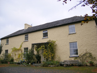
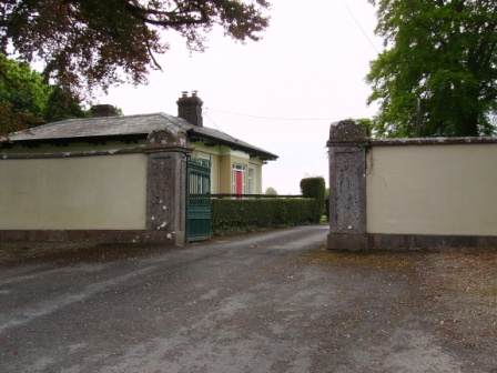
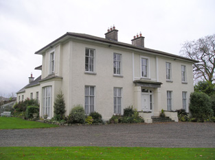
| Grange Hill | Leet records Grange-Hill as the residence of Edward Croker in 1814. Edward John Croker was resident at the time of the first Ordnance Survey. It was a residence of the Count De Salis at the time Griffith's Valuation. The Count held it in fee and the buildings were valued at £27. The Count was still the occupier of Grange in 1906. Owned by Colonel and Mrs Galloway in 1942. The house is now known as Loughgur. |
|
| Camas | The seat of the Bevan family located on the estate of the Earl of Limerick. At the time of Griffith's Valuation, it was held by Frederick Bevan from the Earl of Limerick and valued at £29. The house is now demolished but the farm buildings remain. |
|
| Rathanny | A house situated on the estate of the Earl of Limerick, occupied by John Sheeran in 1814 and by T. Bennett in 1837. Thomas F. Bennett was still resident at the time of Griffith's Valuation when the buildings were valued at £15. |

|
| Baggotstown | The seat of the Bourchier family in the 18th and 19th centuries, valued at £32+ in 1906. The Irish Tourist Association surveyor writes in 1942 that this house was built in 1745 (keystone) and had lately been acquired by Mr T. Mitchell, a solicitor. This house has recently been renovated. |
|
| Kenmare Castle | Joseph Gubbins of Kenmare Castle is recorded in 1814. Lewis refers to the pretty cottage erected by J. Gubbins on the site of Kenmare Castle in his entry for the parish of Hospital, circa 1837. James Gubbins was residing in a house valued at £23 at the time of Griffith's Valuation. He held the property from the Earl of Kenmare. |

|
| Castlefarm | Castlefarm was the residence of Mr Patrick Sheeran in 1814. By 1837 Standish O'Grady was the occupier and he was still living there at the time of Griffith's Valuation when the house was valued at £16. He held the property from the Earl of Kenmare. |

|
| The Grange | The home of the Grady/O'Grady family in the 18th and 19th century. In 1786 Wilson describes it as "the beautiful and well-improved seat of Standish O'Grady". It was inherited by the Crokers in 1861. Occupied by Standish [O'] Grady in 1814 and Henry O'Grady in 1837 and at the time of Griffith's Valuation. The buildings were valued at £77 and the property was held in fee. In 1894 it was noted by Slater as the seat of Captain Edward Croker. This house was described as in very good repair even though it had not been occupied for a number of years preceding the Irish Tourist Association survey of 1942. The house is now a ruin. |
|
| Rawleystown Court | Lewis writes that "in the parish of Cahercorney are the remains of Raleighstown, an ancient building erected by the uncle of Sir Walter and afterwards the property of the Croker family, who built a splendid house here, now in ruins". The Ordnance Survey Name Book states that the house was built about 75 years previously by the Crokers and that it was afterwards sold to one of the workmen employed in building it who immediately destroyed it. In 1786 Wilson refers to "Rawlen's-town/Rawleigh's-town" as a seat of the Croker family. The first Ordnance Survey map marks the house as a ruin. | |
| Kilfrush | The home of Joseph Gubbins from at least 1837 and held in the early 1850s from the Court of Chancery. It was valued at £70 and was still the home of the Gubbins in the 1870s and in 1906 when it was valued at almost £66. According to the Irish Tourist Association survey it had been built in 1825 and was still the home of Mrs Gubbins in 1943. It is still extant. |
|
| Ballincolloo | This house was the residence of Mrs Bennet in 1814 and by 1837 of J. Gubbins. Joseph L. Gubbins occupied the house at the time of Griffith's Valuation holding it from the representatives of Samuel Bennett. It was valued at £14. It is no longer extant. | |
| Elton | In 1786 Wilson notes Elton as the seat of Mr.Grady. Leet records the Reverend Thomas Grady [of Cappercullen] as the occupier of Elton in 1814. Mrs Grady lived at Elton in 1837 and Mrs Mary Jane Grady was resident at the time of Griffith's Valuation. She held the property in fee. The buildings were valued at £34. Described in the rental of 1853 as having a "cheerful and commanding aspect". The tenant from year to year was John Simms. In the later part of the 19th century this house belonged to the Bevans of Camas. The original house is not extant. | |
| Kilballyowen | In 1786 Wilson refers to Kilballyowen as the seat of Mr. O'Grady. This was the main seat of the O'Grady family, described by Lewis as a "handsome modern building" circa 1837. At the time of Griffith's Valuation the buildings were valued at £41. By 1906 they were valued at £70 and the property was still in the possession of 'The O'Grady'. The Irish Tourist Association surveyor lists the types of artifacts, paintings etc to be found in this home of Madam O'Grady in 1942. The house was demolished post 1968. |
|
| Cahir Guillamore | The seat of the O'Grady family from the mid 18th century acquired through marriage with a member of the Hayes family. Held by the Viscount Guillamores in fee and valued at £50 in the early 1850s. Viscount Guillamore was recorded as the occupier in 1906 when the house was valued at £48. The Irish Tourist Association surveyor in 1942 refers to this house as been unused since 1922 when the estate was divided by the Land Commission. All the fittings has been removed and only the shell of the house remained. The house is now a ruin. |

|
| Towerhill | This property was the original residence of the Lloyd family where they settled in the 17th century. It passed to William, second son of Reverend Thomas Lloyd of Towerhill. Occupied by William's son, Reverend Rickard Lloyd, in 1814. The buildings were valued at £31 at the time of Griffith's Valuation when William Lloyd was the occupier. The property was held from the Stafford O'Briens. Purchased by the Devanes at the end of the 19th century, the house is now in ruins. |
|
| Abington House | Abington House in the townland of Dromeliagh is marked on the first Ordnance Survey map. In 1786 Wilson states "at Abingdon, is a very pleasant seat of Sir Nicholas Lawless". At the time of Griffith's Valuation a house valued at £17 was occupied by Michael Apjohn in this townland. In the 1860s this house was occupied by John Connell Fitzgerald and his wife Margaret (Apjohn). ''The Limerick Chronicle'' of 1 Oct 1872 records the death of Mary Anne Apjohn of Abington House, widow of Michael Apjohn. The property was held from Lord Cloncurry. A ruined house is still extant at the site. |
|
| Dooneen | The Reverend Fitzgerald writes that this house was "lately" built by Villiers Peacocke. The Ordnance Survey Name Books records 1820 as the date of its erection. Villiers Peacocke was still in residence in 1837 and Griffith's Valuation records him holding the property in fee. The buildings were valued at £18. It was included in the sale of the life estate of Eugene Kieran in the Land Judges' Court in April 1890 when the house was described as "a very good dwelling house.....suitable for a gentleman's residence". The sale was adjourned. A house is still extant at the site. | |
| Bulgaden Hall | An early residence of the Lords Carbery in county Limerick. Described by Lewis in 1830s as in a "ruinous condition". The site of Bulgaden Hall is noted on both the 1st and 25-edition Ordnance Survey maps. | |
| Eyon | The Ordnance Survey Name Book records this house as costing £500 to build in 1838 when it became the seat of Mr Richard Laffan. The house valued at £12+ at the time of Griffith's Valuation, was occupied by Richard Laffan, a dairy farmer. Laffan held the property from Edward B. Hartopp. ''Burke's Irish Family Records'' records Edward Lloyd of Eyon in the mid 18th century. | |
| Mount St Lawrence | Joseph Hannan held a house valued at £17 and a demesne of 94 acres from Edward B. Hartopp at the time of Griffith's Valuation. The Ordnance Survey Name Books record Joseph Harman as the resident circa 1840. A house is still located at this site. | |
| Mountminnett | Mountminnett was the location of the Minnitt family at the end of the 17th century. This house was the home of a branch of the Gabbett family in the first half of the 19th century. It was occupied by William Gabbett in the early 1850s when the buildings were valued at £11 and the Gabbetts held the property from Sir Richard Bourke. William Gabbett of Mountminnett owned 397 acres in county Limerick in the 1870s. | |
| Caherline | [The seat of the Gabbett family in the 18th and early 19th centuries]. Lewis refers to its occupation by a farmer and Griffith's Valuation records Thomas Barry as resident in the early 1850s when the buildings were valued at £16. The original house is still extant though with some modifications. It is now the home of the O'Grady family. | |
| Highpark | A property in the possession of the Gabbett family from the early 18th century. Described in the Ordnance Survey Name Book as having a "decayed appearance", this three-storied house was built between 1759 and 1789. The house, valued at £10, was vacant at the time of Griffith's Valuation. It is still extant. |

|
| Ballyvorneen | This house is marked on the first edition Ordnance Survey map at the site of a castle. Described as a "dairyman's house" at the time of Griffith's Valuation and held by William and Thomas Gabbett, younger brothers of Joseph Gabbett of High Park, in fee. The buildings were valued at £15. The house no longer exists. |

|
| Caherconlish House | Lewis describes this house in the following terms "Near the town stands Cahirconlish House, a handsome modern residence, erected near the site of the old family mansion, by the proprietor, Major Wm Wilson." The Ordnance Survey Name Book dates this house to about 1789 and it was three storeys high. Wilson, writing in 1786, refers to a residence of Mr. Wilson at Caherconlish. A small drawing of the house is to be found on Map 16 H 32 (13) in the National Library of Ireland. This house was valued at £40 at the time of Griffith's Valuation and was held by Charles Monck Wilson in fee. Daniel Fitzgerald Gabbett, MP, was recorded as the owner in 1906, though he himself had died in 1898. At the time of the Irish Tourist Association survey 1942 Caherconlish House is described as a Creamery. The surveyor writes that a fine Adams ceiling in the house was destroyed by an accidental fire in 1925. Caherconlish is no longer extant. | |
| Ballynagarde | The seat of the Croker family from early in the 18th century. Bence Jones writes that the house was built in 1774 and that it became a ruin during the 20th century. It was valued at £70 in the mid 19th century and held in fee by John Croker. The seat of H.S. Croker in 1894. By 1906 this house was valued at £119+ and was occupied by Courtenay Croker. The Irish Tourist Association Survey records the occupation of this house by the Defence Forces in 1942. It is now a ruin. |

|
| Caherelly Castle/Coole House | Lewis refers to Mrs Furnell’s residence as "a neat building in the cottage style" situated near Longford bridge. The substantial house marked at this location on the first Ordnance Survey map is named Caherelly Castle but on later maps is recorded as Coole House. The Ordnance Survey Field Name Book call it Cahir Elly Castle or Coole House. It was valued at £30 and occupied by Michael Furnell who held it in fee at the time of Griffith's Valuation. This house may have been known as Caherelly Grange in the last decades of the 19th century (see ''Burke's Irish Family Records''). The house is no longer extant but the outbuildings still remain. | |
| Caherelly Cottage/Caherelly Castle | A plaque records the building of this house in 1800 by William Hannan. Lewis refers to the residence of Mr Hannan in well planted grounds. The Ordnance Field Name Book refers to Cahir Elly Cottage as the residence of William Hannan. Marked as Caherelly Cottage on the first Ordnance Survey map, this house was located close to the ruins of an old castle and is now known as Caherelly Castle. Valued at £12 in the early 1850s and occupied by Michael Furnell who held it in fee. It later became the home of Michael Furnell's brother Frederick, an army surgeon. David O'Shaughnessy's interest in this house was advertised for sale in October 1853. |

|
| Boskill | Lewis records B. Friend residing at Baskill in 1837. The Ordnance Survey Field Name Book records two houses. Boskill House the original residence of the Frends dating back to the 17th century and located at the northern point of the townland. It was at the end of the 1830s a thatched house which had been converted into a stable. Boskill Lodge (marked on the first Ordnance Survey map as Boskill House) was built in 1800 by Captain Benjamin Frend, at a cost of about £600. At the time of Griffith's Valuation Benjamin Friend junior occupied this house which was valued at £18. In 1906 a mansion house in the townland of Templemichael valued at £30.15 shillings was the residence of Edith M. Minchin and Agnes E. Rose. The Frends and the Roses of Ardhu House were related. The Irish Tourist Association surveyor in 1942 records the burning of this house in the Civil War and that there was "no trace of the house now". | |
| Lombardstown | The Ordnance Survey Field Name Book states that this house was rebuilt in 1823 by the occupier Thomas O'Brien. It was still occupied by Thomas O'Brien in the early 1850s. The buildings were valued at £11 and the property held from Lady Charlotte Wolfe. | |
| Coolyhenan House | A house occupied by Michael Shine at the time of Griffith's Valuation and held from the representatives of M. Honan, valued at £28, with a demesne of 343 acres. Though buildings survive at the site they appear to be in a derelict condition. | |
| Edwardstown | Edwardstown was the residence of John Russell in the early 1850s held by him in fee and the buildings were valued at £18+. |

|
| Roxborough | Occupied by William Westropp in 1814 and Lewis refers in 1837 to the ''fine mansion and demesne'' of the Honourable J. P. Vereker. The Ordnance Survey Name Book refers to the rebuilding of Roxborough by Major Vereker in 1832 at the expense of approximately £1200. Viscount Gort held Roxborough in fee at the time of Griffith's Valuation when it was valued at £40. The house was advertised for sale in June 1852 and again in June 1853. Possibly bought by the McMurrays who were certainly resident by 1862. In 1894 Slater refers to it as the seat of A. Crawford. Now a more modern house appears to be located at this site. |
|
| Lickadoon | The Ordnance Survey Field Name Book records the date for the building of this 3 storey house, the seat of George Parsons, as circa 1779 at a cost of about £1000. By the time of Griffith's Valuation John O'Brien was residing at Lickadoon which he held from George Biggs. The buildings were valued at £20. In 1942 this house was the property of Mr William Leahy, a solicitor, and formerly the residence of the the Urquhart Hunts (ITA). | |
| Glen View | John Russell was the occupier of a house at Glen at the time of Griffith's Valuation. He held the property from Miss Abigail Briscoe and the buildings were valued at £15+. Slater also recorded Glenview as the seat of John Russell in 1894. This house is now demolished. |

|
| Ahabeg | Built in 1827 this house was the home of the Rose family in the 19th century. It was occupied by Michael Lloyd who held it from Counsellor Richard Rose circa 1840. The residence of Richard Rose held by him in fee at the time of Griffith's Valuation and valued at £18+. Aghabeg is still extant and well-maintained. | |
| Ballyclogh House | The Ordnance Survey Field Name Book refers to the building of this house in 1822 by Henry Rose as a cost of £600. Occupied by P. Cudmore in the 1830s and by Henry Rose at the time of Griffith's Valuation who held the property from the representatives of Samuel Dixon [Dickson]. The buildings were valued at £9+ in the 1850s. Ballyclogh is still extant. |

|
| Maddyboy | Occupied by John Burke in 1814, by Captain Wickham in 1837 and by Benjamin Lucas in the early 1850s. The buildings were valued at £14 and the property held from John Lucas. | |
| Dromkeen | In the early 1850s John Hussey de Burgh lived in this house, situated near the old home of the Burgh family, also named Dromkeen. He held the property in fee. The buildings were valued at £19+. By 1906 Dromkeen was valued at £10. | |
| Dromkeen House | Fitzgerald refers to the old mansion of the Burghs as standing opposite the old walls of a church. Lewis refers to Dromkeen as "formerly the residence of the Burgh family" then occupied by the Reverend M. Lloyd, and that "the remains of the ancient mansion show it to have been an extensive and important establishment". A house at this site was occupied by Henry Croker at the time of Griffith's Valuation and valued at £34. It was held from Robert Smithwick. The Ordnance Survey Name Book refers to this house as William's Fort and states that it first belonged to the Burgh family and was rebuilt in 1820. Valued at £17 in 1906 and occupied by Digby H. De Burgh. |

|
| Williamstown Castle | Lewis refers to Williamstown Castle having been restored by the Messrs Pain, architects. In the early 1850s John Croker is recorded as the occupier, holding the property in fee. The buildings were valued at £33. It is now a ruin. | |
| Rockstown House | A building valued at £18 at the time of Griffith's Valuation, occupied by Chartres Brew Maloney and held from James Kelly. Chartres Brew Molony, second son of Patrick Molony of Cragg married his cousin Alice, daughter of James Barry of Rockstown, in 1841.Rockstown Castle was inherited by James Kelly's grandson, Basil James Kelly, in the 20th century and was left by him to his nephew Derrick Morley in 1945. It is still extant |

|
| Sandville | The home of the Barry family in the 18th and 19th centuries, the house became known as Sandville in the early 19th century. The Ordnance Survey Name Book dates the building 1799. John Barry occupied this house on the Kelly estate at the time of Griffith's Valuation when the buildings were valued at £26. John Grene Barry was resident in the 1870s and 1880s. Buildings are still extant at the site. | |
| Friarstown (Grange) | At the time of Griffith's Valuation this house was held from James Kelly by James H. Barry, the buildings were valued at £12. In 1906 Bazil R. Kelly held about 400 acres of untenanted land and buildings valued at £12 at Friarstown. This house is still extant. |

|
| Mountsion | Occupied by Robert Bradshaw in 1814 and by Helenus White in the early 1850s. The buildings were valued at almost £9 and were held in fee. | |
| River Ville [Mulkear] | Built circa 1800 and the seat of Arnold Hill circa 1840 this house was occupied by Samuel F. Dickson at the time of Griffith's Valuation and held by him from William D. Farrer with 206 acres, The buildings were valued at almost £16.The house is labelled River Ville on the 1st edition Ordnance Survey map but as Mulkear on the 25-inch edition of the 1890s. A house is still extant at the site. | |
| Ballysheedy | A 3 storey house built circa 1749, occupied by FitzGillon in the late 1770s and noted by Wilson as the seat of Gibbon Fitzgibbon in 1786. It was the residence of Michael Furnell in 1814 and occupied by Gibbon T. Fitzgibbon in the early 1850s, when it was held from Admiral Proby and valued at £22. It was ruinous by the publication of the 25-inch Ordnance Survey map of the 1890s. | |
| Ballynamona | A small property known as Quarryfield Cottage occupied this site at the time of the First Ordnance Survey. The property here was the home of George Vandeleur in the 1870s. On the later 25-inch map of the 1890s a much larger property, labelled Ballynamona House, is shown. A house is still extant at the site. | |
| Ballymacreese | A residence of the Greene family in the 18th century and noted by Wilson as the seat of Mr. Greene in 1786. The Ordnance Survey Name Books refer to this house as the seat of Mr James Shine, rebuilt in 1829 at a cost of £900. Occupied by James Shine in the early 1850s and held from the representatives of Frederick Lloyd. The buildings were valued at £26. Jeremiah Shine of Ballymacreese owned 79 acres in the county in the 1870s. The house is still extant and well-maintained. |

|
| Ballybrood | A house in the village of Ballybrood, the residence of a branch of the Maunsell family in the 18th and early 19th centuries. Occupied by Samuel Maunsell at the time of Griffith's Valuation and held by him in fee. The buildings were valued at £11+. | |
| Rockview | A 2 storey house on the Croker estate, built in 1837 for £400, it was occupied by George Peacock circa 1840 and in the early 1850s when it was valued at almost £12. There is still an extant house at the site. |

|
| Bruree Lodge | Bruree was the home of the Langton family in the 18th century. The house was occupied by Michael Ryan at the time of Griffith's Valuation and held from Michael Shaughnessy, it was valued at £13+. |
|
| Bruree House | Bruree House was also located on the Langton estate although at the time of the first Ordnance Survey the property was in the hands of Robert Fetherston who held a number of townlands in the parish, possibly from the Langtons. At the time of Griffith's Valuation the house was in use as an auxiliary workhouse. In 1853 Bruree House was sold to a member of the Shelton family and in 1868 it was sold to John Gubbins of the Kilfrush family. He was a successful racehorse owner and in 1884 built the present Bruree House. When he died in 1906 the property passed to his nephew John Norris Browning. The house was valued at £92 at this time. Owned by the Sheehans and Vernons in the 20th century. Now function as as a rehabilitation centre, known as Cuan Mhuire. A print entitled "The Lawn Meet" by Patrick Hennessy depicts this house. See www.museum.limerick.ie |

|
| Mount Catherine | A house on the Lloyd Apjohn estate, the home of the Smithwick family from about the mid 18th century and occupied by Michael Smithwick in the early 1850s, when the house was valued at £24. The Smithwicks of Mount Catherine and the Lloyd Apjohns were related through at least one marriage. |

|
| Sunville | Sun-Ville, Pallas-Green was the residence of Thomas Apjohn at the end of the 18th century and of John Ryan esquire in 1814. In the early 1850s it was occupied by Thomas Kearney and held from Michael Apjohn. The buildings were valued at £33. Thomas Kearney was County Surveyor for the East Riding of county Limerick, 1837-1862 and for Limerick city 1852-1853. His daughter Olivia married in 1854 Michael Marshall Lloyd Apjohn of Linfield. see http://www.dia.ie/architects/view/2903. It is still extant. |

|
| Landscape | The Reverend M. Lloyd Apjohn was the occupier of this house at the time of Griffith's Valuation. He held it in fee and it was valued at £21. The original house is not extant and a modern building has been constructed at the site in this century. | |
| Pallas House | At the time of Griffith's Valuation this house was occupied by Thomas Apjohn who held the property from the Trustees of E. Smith's Charities. The National Inventory of Architectural Heritage suggests it was constructed in the 1790s. The building is still extant. |
|
| Derk | The home of the Considine family in the 19th and 20th centuries and formerly of the Heffernan family. At the time of Griffith's Valuation the house was valued at £40 and held in fee. Bence Jones writes that this house was sold in 1971. |

|
| Newtown House | In 1786 Wilson refers to Newtown as the seat of Mr. Ellard. Occupied by Miles Ryan in 1814 and by Richard Ellard at the time of Griffith's Valuation. Ellard held the property from - Keating and the buildings were valued at £13. Lewis refers to Newtown Ellard as the ancient seat of the Lloyd family. In 1906 this house valued at £23.10 shillings was occupied by Mary R. Ellard. It is still extant. |
|
| Castle Ievers | The Ievers were living at Castle Ievers, originally known as Tullerboy, from the mid 18th century. Bence Jones dates this house from the early 19th century. Robert Ivers was resident in 1814, 1837 and at the time of Griffith's Valuation when the buildings were valued at £32. The property was held from William Maunsell. The Irish Tourist Association surveyor wrote in 1943 that much of Tullerboy Castle was demolished in the 1860s to make way for the present building. The owner in the 1940s was Roderic Haines. |

|
| Coolboy | A herd's house and offices situated on the St Leger estate was occupied by Henry Ievers at the time of Griffith's Valuation when the buildings were valued at £14+. Coolboy was occupied by the representatives of Robert Cleary in 1906. A substantial farm is still extant at the site. | |
| Greenpark | In 1814 and 1837 this house was the residence of Richard Ievers, brother of Robert Ievers of Castle Ievers. At the time of Griffith's Valuation it was occupied by Mrs Sarah P. Fitzgibbon, the wife of Richard Ievers who had remarried. She held the property from Alcock Otley and it was valued at £36. This house is now a ruin. |

|
| Cooleen | At the time of Griffith's Valuation William Hart Mason held the townland of Cooleen amounting to 88 acres in fee. The buildings were valued at £12. |
|
| Cherrygrove | Cherrygrove was the home of Edward Cripps in 1814 and of J. Barry in 1837. At the time of Griffith's Valuation it was occupied by Edward John Sheehy who held the property from Robert Harding. The buildings were valued at £21+. The Misses Sheedy were still in residence in the 1940s. A building is still extant at the site. | |
| Belview/Bellevue | A home of the Yielding family, occupied by Richard M. Yielding in 1814 and 1837 and by Timothy Hartigan who held the property from James Barry at the time of Griffith's Valuation. The buildings were valued at £13 at that time. Bought by the Delmeges in the early 1850s. The original house is not extant. | |
| Carass House | Caherass/Carass House was the seat of the Roche family from the early 19th century. The family had a large flour mill in the townland of Caherass and the house was situated closeby but in the next townland. At the time of Griffith's Valuation Sir David Roche held the house and 235 acres in Ballouragan from Messrs Barrington and Delmege. In 1894 it was the seat of Sir David V. Roche. In 1943 the Irish Tourist Association surveyor wrote that the house was accidentally destroyed by fire "many years ago". | |
| Clorane | A house occupied by Henry Hunt in 1814. Lewis describes Clorane as a "fine old house belonging to the Hunt family". By the time of Griffith's Valuation Edward Browning was leasing the house and 280 acres from Sir David Roche. In the 1870s in the possession of Patrick Hartigan. Old farm buildings are still located at the site but the house is a modern structure. |

|
| Croom House | Croom House was the home of the Lyons family in the 18th and 19th centuries. The house of James D. Lyons was valued at £48 in the early 1850s and he had a flour mill valued at £75 closeby. He held the property from John Croker. Described in 1943 by the Irish Tourist Association surveyor as a beautiful mansion on the left bank of the Maigue river, it was then in use as a military post. The house is still extant and occupied. |

|
| Islandmore | Tooreen, located just south of the town of Croom, was the residence of James D. Lyons in 1814 and 1837. By the early 1850s this house, then known as Islandmore, was occupied by Robert Maxwell, valued at £60 and held from Miss Catherine Giles. It later became the home of the Kelly family and Slater refers to it as the seat of John Roche-Kelly in 1894. Colonel Basil Roche Kelly was resident at the time of the Irish Tourist Association survey of 1943. The surveyor wrote that the house was originally Georgian but had suffered many alterations. |
|
| Croom Castle | Originally a Fitzgerald Castle, subsequently granted to the Duke of Richmond who sold it to John Croker in 1721. Reverend Fitzgerald writes that Croker was agent to the Duke. A residence was built with some of the stone from the old castle. Situated on the outskirts of the town of Croom this house was occupied by Samuel A. Dickson in the mid 19th century who held it from the Crokers. The buildings were valued at £30. Sold in the late 1880s to the Lyons family and bought by Michael Corry in 1936. Now functions as self catering accommodation. see http://www.croomcastle.com/history.html |

|
| Glenbevan | Lewis records J. Bevan as the proprietor of Glen-Bevan in 1837 and Joseph Bevan occupied the house and 173 acres at the time of Griffith's Valuation. The property was located on the Evans estate. The residence of Mr John Hedderman in 1943, this house is still extant and occupied. |

|
| Clogher West | A house occupied by John Fitzgerald and held from George Whitelock at the time of Griffith's Valuation. The buildings were valued at £12. The original house does not appear to be extant. | |
| Maidstown Castle | Originally known as Ballyvenoge, Seoighe writes that John Ormsby first lived at Maidstown which he sold to the Webbs when he went to live at Athlacca. By the mid 18th century the Webbs had sold Maidstown to the Gubbins. The home of a branch of the Gubbins family in the late 18th century and early 19th century. The house was valued at £20 and held by Patrick Coll from John White in the mid 19th century. The Colls sold Maidstown to the O'Regans in 1972. A house is still extant at the site as well as the ruin of the original tower house. | |
| Abbeyville | A house located on the Finch estate and the home of the White family in the 19th century. Occupied by William White in 1814 and Richard White in 1837 and at the time of Griffith's Valuation when the buildings were valued at £26. Later the home of Henry Ievers, a younger brother of Robert Holmes Ievers, of Castle Ievers. The original house is not extant but a house still exists at the site. |
|
| Ballynanty | Ballynauty was the residence of Mrs Creed in 1837 and of Charles W. Smith in the early 1850s. He held the property from the Trustess of Charles Smith and the buildings were valued at £37 Still recorded by Slater as a Smith property in 1894. . The original house is not extant. | |
| Rockbarton | Also known as Mount Prospect, Fitzgerald describes Mount Prospect as the "magnificent seat and demesne of the present Chief Baron". Lewis describes Rockbarton as the "elegant mansion of Lord Guillamore". It was occupied by John Low at the time of Griffith's Valuation who held it from the Viscount. It was valued at £75. By 1906 the value of the house was reduced to £60 and it was then occupied by Lord Fermoy. The Irish Tourist Association surveyor records the sale of this house to Mr Barry in 1922. It remained in his possession until it was demolished in 1941 and the fittings sold to a Limerick builder. He writes that it was one of the "showplaces of Ireland" with a grand staircase of marble and that it had been renovated at a cost of £70,000 circa 1912 by the Honourable Nigel Baring who was married to a daughter of Lord Fermoy.The house is now a ruin. | |
| Uregare House | Owregare House was the residence of Mrs Gubbins in 1837 and of Mrs N. Barron who held the property from William G. Gubbins at the time of Griffith's Valuation. The buildings were valued at £22+. This house was also known as Newlawn. Fitzgerald writes that it belonged to the Creed family before the Gubbins. Occupied by Thomas A. Dicken in 1906. This house is no longer extant. | |
| Milltown | In the 18th century Miltown was the residence of a branch of the De Lacy family. Mill-town, Bruff, was the residence of Mrs Bevan in 1814. George Gubbins was the occupier in 1837 and at the time of Griffith's Valuation. He held the property valued at £40+ from Edward B. Hartopp. In 1831 George Gubbins married Elizabeth Blood nee Hartopp. This house is named Milltown George on the first Ordnance Survey map. |

|
| Summerville | Occupied by the Reverend Joseph Gabbett, fifth son of Daniel Gabbett of Strand House, Chancellor of Limerick and Prebendary of Effin and held by him from Alcock Otley. The buildings were valued at £23+. In 1786 Wilson refers to a house at Uregare as the seat of General Gabett. A house is still extant at the site. | |
| Mount Coote | The county Limerick seat of the Coote family in the 18th and 19th centuries. Wilson refers to it as "the pleasant seat of Mr. Coote" in 1786. It was occupied by Chidley Coote in 1814. Lewis refers to it as the former seat of Chidley Coote in 1837. Charles Coote was resident at the time of Griffith's Valuation and held the property in fee. The buildings were valued at £53. Their value had increased to £65 by 1906. The Irish Tourist Association surveyor wrote in 1943 that the house was bought by Sir Gilbert Greenall, who became 1st Lord Daresbury, who spent about £200,000 setting up a Model Farm. [Lord Daresbury also owned Clonshire]. Following his death three years previously it was sold and then run as a stud farm. Bence Jones writes that this house was demolished circa 1960 and a new house built in the Georgian style. |

|
| Riversfield | A house located on the Coote estate, occupied by Thomas Weldon in 1837 and at the time of Griffith's Valuation when the buildings were valued at £20. John H. Weldon of Riversfield owned 68 acres in county Limerick in the 1870s. Occupied by Mr and Mrs Watt in 1943. It is still extant. | |
| Martinstown | Martinstown was the residence of M. Walsh in 1837. At the time of Griffith's Valuation this was a house on the Trench/Gascoigne estate valued at £10+ and inhabited by William O'Grady. Bence Jones refers to a modern house built in circa 1972 at Martinstown, Kilmallock. | |
| Millmount | Occupied by the Reverend Joseph Gabbett and held from Daniel Gabbett at the time of Griffith's Valuation, when the buildings were valued at £16. It is labelled Millmount on the First Edition Ordnance Survey Map and as Ardvullen on the later 25-inch edition of the 1890s. A house is still extant at the site. | |
| Ash Hill Towers | The residence of a branch of the Coote family in the 18th century, possibly held from the Barons Carbery. Ash Hill is referred to by Wilson as the seat of Chudleigh Coote in 1786. Bought by Eyre Evans from Chidley Coote in 1794 (see sale rental 6 July 1878). Eyre Evans held the property in fee throughout the first half of the 19th century. The Ordnance Survey Field Name Book describes this house as having "a most superb new front with towers at each end". At the time of Griffith's Valuation the buildings were valued at £50. Bence Jones writes that Ash Hill Towers became the residence of John Henry Weldon in the later 19th century. The Irish Tourist Association surveyor wrote in 1943 that the property was owned by Captain P.M. Lindsay, nephew of John H. Weldon, who bought the house from the Evans family in 1880. Still extant, this house is the centre of a stud. |
|
| Ryves Castle [Castle Jane] | Ryves Castle, previously known as Castle Jane, was the home of the family of this name in the 18th and early 19th centuries. It is referred to as Castle Jane by Wilson in 1786 when he notes it as the seat of Mr. Ryves. By the 1830s however William H. Ryves of Ryves Castle appears to have moved to live in Brighton, as the birth of many of his children is recorded in the Limerick newspapers as having taken place there. In 1826 Fitzgerald records Ryves Castle as the residence of John Lowe. Lewis referring to the parish of Knocklong, notes that Thaddeus R. Ryan was resident at Castle Jane and that there was a vault of the Lowe family located in the grounds of Ryves Castle, that family having previously been its proprietors. For the parish of Ballyscanlan he records Ryves Castle as the residence of P. [T?] Ryan. At the time of Griffith's Valuation the house was valued at £29 and occupied and held in fee by William H. Ryves. In 1906 it was valued at £31 and was occupied by Thomas J. Franks. Later owned by Mr D. Fleming, this house is now demolished. | |
| Scarteen | Thaddeus R. Ryan was resident at nearby Castle Jane [Ryves Castle] in 1837 as recorded by Lewis and Scarteen was unoccupied. John Ryan was the occupier of Scarteen in the early 1850s when the house was valued at £30+. He held the property from William H. Ryves. His widow Alice owned 50 acres in county Limerick in the 1870s. The Ryans still live at Scarteen where the famous pack of hounds of that name is kennelled. |

|
| Ballynahinch | A house valued at £11 occupied by Thomas Cleary at the time of Griffith's Valuation and held with 354 acres from the Trench/Gascoigne estate. Thomas Cleary of Ballinahinch owned 454 acres in county Limerick in the 1870s. A house is still extant at the site. | |
| Harding Grove | Occupied by G. Harding in 1814 and H. Harding in 1837. The seat of Mr Harding at the time of the first Ordnance Survey. By the time of Griffith's Valuation a Neill McDonald was in possession of Harding Grove. Neil Macdonald of Steyle Park, Bruree owned 354 acres in county Limerick in the 1870s. Francis H. Wyse is recorded as the occupant of Harding Grove in 1906. |

|
| Athlacca House | A residence of the Ormsby family in the 18th century. On the first Ordnance Survey map the house is marked "in ruins". Also known as Old Court. | |
| Ballygrennan Castle | Granted to the Evans family under the Acts of Settlement. In the early 19th century the residence of William Creed. Described as "in ruins" on the 1st edition Ordnance Survey map. Some portions of the building remains though much of the stone has been removed. | |
| Friarstown | The National Inventory of Architectural Heritage states that he house was built in 1827 for David Urqhart Hunt and cost £10,000. At the time of Griffith's Valuation the house was occupied by Henry Hunt who held it from the Reverend Richard Maunsell, valued at £35. This property is now known as Friarstown Stud. |

|
| Knocktoran | This late 19th century seat of the Webb family is now a stud farm. Anna Thomasina Webb occupied the house in 1906 when it was valued at £32. Owned by Major S.N.C. Webb in 1943. It is still extant. |
|
| Clonkeen House (Barrington) | Croker Barrington, second son of Sir Croker Barrington, was the occupant of a mansion house at Clonkeen (Barrington) in 1906, valued at £48. The Barringtons owned a house in this area at the time of Griffith's Valuation which was valued at almost £10. This older property is known as Clonkeen House and was enlarged later in the nineteenth century. The 25-inch Ordnance Survey Map of the 1890s shows a second property, labelled Barrington's Bridge House [R683547]. This latter property is locally known as The Red House. Houses are still extant at both sites. Clonkeen House was offered for sale in 2013. |

|
| Cahernarry House | Originally a Cripps residence, occupied by a member of the Crips family in the 1770s and 1780s and by J. Cripps in 1837. By the time of Griffith's Valuation Henry Watson was in residence. The house was valued at £8. It is not visible on the 25-inch Ordnance Survey map of the 1890s. Modern farm buildings occupy the site now. | |
| Ballynacree House | A house valued at £10 and held from Samuel Dixon by Michael Manning in the mid 19th century. Ballynacree is still extant. |

|
| Cloverfield | In 1786 Wilson mentions a house called Cloverfield three miles beyond Caherconlish as the seat of Mr. Lloyd. A house named Cloverville is marked on the first edition Ordnance Survey map. On later maps a much larger building is marked. At the time of Griffith's Valuation valued at £9.5 shillings was vacant in this townland. Richard Laffan, a dairy farmer, is recorded as the immediate lessor. The National Inventory of Architectural Heritage dates the original building from circa 1830 with later 19th century additions. The house continues to be used as a residence. |

|
| Knockainy Cottage | Possibly located on the estate of the Earl of Kenmare who owned land in this parish in the mid 19th century. On the first edition Ordnance Survey map this building is named Knockainy Cottage. Later maps show a much larger building now known as Knockainy Stud. |

|
| Kildromin | In 1786 Wilson refers to "Kildrummond" as the seat of Mr. Lloyd. At the time of Griffith's Valuation, a house in Kildromin townland, valued at almost £4 was being leased by James Fitzgerald from the Apjohn estate. There is still a substantial farm at the site. | |
| Kilteely House | In 1786 Wilson refers to Kilteely as the seat of Mr. McNamara. By the time of Griffith's Valuation, much of this townland is the property of John Ryan jnr. This may be the property occupied by Rev. John Madden and valued at almost £8. Kilteely is shown but not labelled on the 1st edition Ordnance Survey map and is labelled Kilteely House on the 25-inch edition of the 1890s. According to the National Inventory of Architectural Heritage it serves as the local Parochial House. |
|