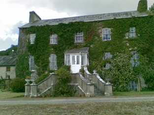
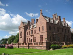
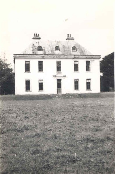
Scarteen
Houses within 15km of this house
Displaying 75 houses.
Houses within 15km of Scarteen
Displaying 75 houses.
| House name | Description | |
|---|---|---|
| Cahercorney | Not named on the the 1st edition Ordnance Survey map, this house was the residence of Henry Croker at the time of Griffith's Valuation. It was valued at £10+ and was held from John Croker. Earlier, in 1786, Wilson refers to it as the seat of Mr. White. A farm is extant at this site now. | |
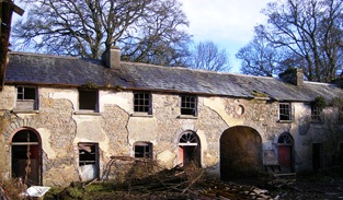
| Loughgur Castle | In 1786 Wilson refers to Lough-Gur as the seat of Henry Baylee. This house was ccupied by John "Boylie" in 1814 and by Miss Bailie in 1837. In the early 1850s William Evans was resident. He held the house valued at £11 from the Count De Salis. It was adjacent to the remains of a tower house known as Bouchier's Castle. The property at this site is labelled "Lough Gur Farm" on the 25-inch map of the 1890s. The book edited by Mary Carbery, "The Farm by Lough Gur", published in 1937, contains a description of the Baylee property at Loughgur. The original Bayley house is no longer extant. | |
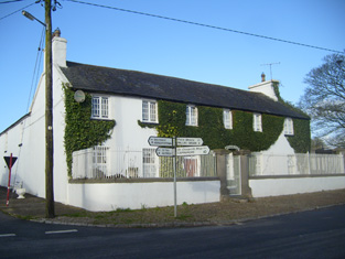
| Grange Hill | Leet records Grange-Hill as the residence of Edward Croker in 1814. Edward John Croker was resident at the time of the first Ordnance Survey. It was a residence of the Count De Salis at the time Griffith's Valuation. The Count held it in fee and the buildings were valued at £27. The Count was still the occupier of Grange in 1906. Owned by Colonel and Mrs Galloway in 1942. The house is now known as Loughgur. |
|
| Camas | The seat of the Bevan family located on the estate of the Earl of Limerick. At the time of Griffith's Valuation, it was held by Frederick Bevan from the Earl of Limerick and valued at £29. The house is now demolished but the farm buildings remain. |
|
| Rathanny | A house situated on the estate of the Earl of Limerick, occupied by John Sheeran in 1814 and by T. Bennett in 1837. Thomas F. Bennett was still resident at the time of Griffith's Valuation when the buildings were valued at £15. |

|
| Baggotstown | The seat of the Bourchier family in the 18th and 19th centuries, valued at £32+ in 1906. The Irish Tourist Association surveyor writes in 1942 that this house was built in 1745 (keystone) and had lately been acquired by Mr T. Mitchell, a solicitor. This house has recently been renovated. |
|
| Kenmare Castle | Joseph Gubbins of Kenmare Castle is recorded in 1814. Lewis refers to the pretty cottage erected by J. Gubbins on the site of Kenmare Castle in his entry for the parish of Hospital, circa 1837. James Gubbins was residing in a house valued at £23 at the time of Griffith's Valuation. He held the property from the Earl of Kenmare. |

|
| Castlefarm | Castlefarm was the residence of Mr Patrick Sheeran in 1814. By 1837 Standish O'Grady was the occupier and he was still living there at the time of Griffith's Valuation when the house was valued at £16. He held the property from the Earl of Kenmare. |

|
| Rawleystown Court | Lewis writes that "in the parish of Cahercorney are the remains of Raleighstown, an ancient building erected by the uncle of Sir Walter and afterwards the property of the Croker family, who built a splendid house here, now in ruins". The Ordnance Survey Name Book states that the house was built about 75 years previously by the Crokers and that it was afterwards sold to one of the workmen employed in building it who immediately destroyed it. In 1786 Wilson refers to "Rawlen's-town/Rawleigh's-town" as a seat of the Croker family. The first Ordnance Survey map marks the house as a ruin. | |
| Kilfrush | The home of Joseph Gubbins from at least 1837 and held in the early 1850s from the Court of Chancery. It was valued at £70 and was still the home of the Gubbins in the 1870s and in 1906 when it was valued at almost £66. According to the Irish Tourist Association survey it had been built in 1825 and was still the home of Mrs Gubbins in 1943. It is still extant. |
|
| Ballincolloo | This house was the residence of Mrs Bennet in 1814 and by 1837 of J. Gubbins. Joseph L. Gubbins occupied the house at the time of Griffith's Valuation holding it from the representatives of Samuel Bennett. It was valued at £14. It is no longer extant. | |
| Elton | In 1786 Wilson notes Elton as the seat of Mr.Grady. Leet records the Reverend Thomas Grady [of Cappercullen] as the occupier of Elton in 1814. Mrs Grady lived at Elton in 1837 and Mrs Mary Jane Grady was resident at the time of Griffith's Valuation. She held the property in fee. The buildings were valued at £34. Described in the rental of 1853 as having a "cheerful and commanding aspect". The tenant from year to year was John Simms. In the later part of the 19th century this house belonged to the Bevans of Camas. The original house is not extant. | |
| Kilballyowen | In 1786 Wilson refers to Kilballyowen as the seat of Mr. O'Grady. This was the main seat of the O'Grady family, described by Lewis as a "handsome modern building" circa 1837. At the time of Griffith's Valuation the buildings were valued at £41. By 1906 they were valued at £70 and the property was still in the possession of 'The O'Grady'. The Irish Tourist Association surveyor lists the types of artifacts, paintings etc to be found in this home of Madam O'Grady in 1942. The house was demolished post 1968. |
|
| Bulgaden Hall | An early residence of the Lords Carbery in county Limerick. Described by Lewis in 1830s as in a "ruinous condition". The site of Bulgaden Hall is noted on both the 1st and 25-edition Ordnance Survey maps. | |
| Mountminnett | Mountminnett was the location of the Minnitt family at the end of the 17th century. This house was the home of a branch of the Gabbett family in the first half of the 19th century. It was occupied by William Gabbett in the early 1850s when the buildings were valued at £11 and the Gabbetts held the property from Sir Richard Bourke. William Gabbett of Mountminnett owned 397 acres in county Limerick in the 1870s. | |
| Ballynamona | A small property known as Quarryfield Cottage occupied this site at the time of the First Ordnance Survey. The property here was the home of George Vandeleur in the 1870s. On the later 25-inch map of the 1890s a much larger property, labelled Ballynamona House, is shown. A house is still extant at the site. | |
| Ballybrood | A house in the village of Ballybrood, the residence of a branch of the Maunsell family in the 18th and early 19th centuries. Occupied by Samuel Maunsell at the time of Griffith's Valuation and held by him in fee. The buildings were valued at £11+. | |
| Mount Catherine | A house on the Lloyd Apjohn estate, the home of the Smithwick family from about the mid 18th century and occupied by Michael Smithwick in the early 1850s, when the house was valued at £24. The Smithwicks of Mount Catherine and the Lloyd Apjohns were related through at least one marriage. |

|
| Pallas House | At the time of Griffith's Valuation this house was occupied by Thomas Apjohn who held the property from the Trustees of E. Smith's Charities. The National Inventory of Architectural Heritage suggests it was constructed in the 1790s. The building is still extant. |
|
| Derk | The home of the Considine family in the 19th and 20th centuries and formerly of the Heffernan family. At the time of Griffith's Valuation the house was valued at £40 and held in fee. Bence Jones writes that this house was sold in 1971. |

|
| Newtown House | In 1786 Wilson refers to Newtown as the seat of Mr. Ellard. Occupied by Miles Ryan in 1814 and by Richard Ellard at the time of Griffith's Valuation. Ellard held the property from - Keating and the buildings were valued at £13. Lewis refers to Newtown Ellard as the ancient seat of the Lloyd family. In 1906 this house valued at £23.10 shillings was occupied by Mary R. Ellard. It is still extant. |
|
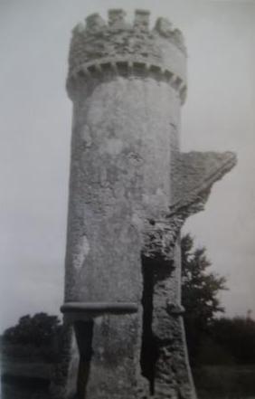
| Castle Lloyd | The seat of the Lloyd family in the 19th century, the sale rental of 1855 records that the original lease was from Robert Bradshaw to the Reverend Richard Lloyd, 8 Nov 1760. IN 1786 Wilson refers to Castle Lloyd as the seat of Rev. Mr. Lloyd. It was occupied by the Reverend Michael Foster in 1814 and by Thomas Lloyd in 1837. Although described by Lewis in 1837 as the handsome residence of Thomas Lloyd, the Ordnance Survey Field Name Book states that the house was in a neglected and decayed state in 1840 due to the death of "the Captain this year". By the time of Griffith's Valuation the house was leased to the Guardians of the Tipperary Union who were using it as a Workhouse. The buildings were valued at £44. Castle Lloyd was advertised for sale in November 1881 on 93 acres. It belonged to Patrick Daly who held it under a fee farm grant dated 12 July 1869 from Letitia Anne Bradshaw to William Daly. The Irish Tourist Association Survey of the early 1940s refers to the demolition of this house about 70 years previously and that only the circular tower remained of the extensive 18th century dwelling built by Captain Lloyd. |
|
| Greenpark | In 1814 and 1837 this house was the residence of Richard Ievers, brother of Robert Ievers of Castle Ievers. At the time of Griffith's Valuation it was occupied by Mrs Sarah P. Fitzgibbon, the wife of Richard Ievers who had remarried. She held the property from Alcock Otley and it was valued at £36. This house is now a ruin. |

|
| Rockbarton | Also known as Mount Prospect, Fitzgerald describes Mount Prospect as the "magnificent seat and demesne of the present Chief Baron". Lewis describes Rockbarton as the "elegant mansion of Lord Guillamore". It was occupied by John Low at the time of Griffith's Valuation who held it from the Viscount. It was valued at £75. By 1906 the value of the house was reduced to £60 and it was then occupied by Lord Fermoy. The Irish Tourist Association surveyor records the sale of this house to Mr Barry in 1922. It remained in his possession until it was demolished in 1941 and the fittings sold to a Limerick builder. He writes that it was one of the "showplaces of Ireland" with a grand staircase of marble and that it had been renovated at a cost of £70,000 circa 1912 by the Honourable Nigel Baring who was married to a daughter of Lord Fermoy.The house is now a ruin. | |
| Uregare House | Owregare House was the residence of Mrs Gubbins in 1837 and of Mrs N. Barron who held the property from William G. Gubbins at the time of Griffith's Valuation. The buildings were valued at £22+. This house was also known as Newlawn. Fitzgerald writes that it belonged to the Creed family before the Gubbins. Occupied by Thomas A. Dicken in 1906. This house is no longer extant. | |
| Milltown | In the 18th century Miltown was the residence of a branch of the De Lacy family. Mill-town, Bruff, was the residence of Mrs Bevan in 1814. George Gubbins was the occupier in 1837 and at the time of Griffith's Valuation. He held the property valued at £40+ from Edward B. Hartopp. In 1831 George Gubbins married Elizabeth Blood nee Hartopp. This house is named Milltown George on the first Ordnance Survey map. |

|
| Summerville | Occupied by the Reverend Joseph Gabbett, fifth son of Daniel Gabbett of Strand House, Chancellor of Limerick and Prebendary of Effin and held by him from Alcock Otley. The buildings were valued at £23+. In 1786 Wilson refers to a house at Uregare as the seat of General Gabett. A house is still extant at the site. | |
| Mount Coote | The county Limerick seat of the Coote family in the 18th and 19th centuries. Wilson refers to it as "the pleasant seat of Mr. Coote" in 1786. It was occupied by Chidley Coote in 1814. Lewis refers to it as the former seat of Chidley Coote in 1837. Charles Coote was resident at the time of Griffith's Valuation and held the property in fee. The buildings were valued at £53. Their value had increased to £65 by 1906. The Irish Tourist Association surveyor wrote in 1943 that the house was bought by Sir Gilbert Greenall, who became 1st Lord Daresbury, who spent about £200,000 setting up a Model Farm. [Lord Daresbury also owned Clonshire]. Following his death three years previously it was sold and then run as a stud farm. Bence Jones writes that this house was demolished circa 1960 and a new house built in the Georgian style. |

|
| Riversfield | A house located on the Coote estate, occupied by Thomas Weldon in 1837 and at the time of Griffith's Valuation when the buildings were valued at £20. John H. Weldon of Riversfield owned 68 acres in county Limerick in the 1870s. Occupied by Mr and Mrs Watt in 1943. It is still extant. | |
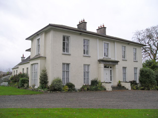
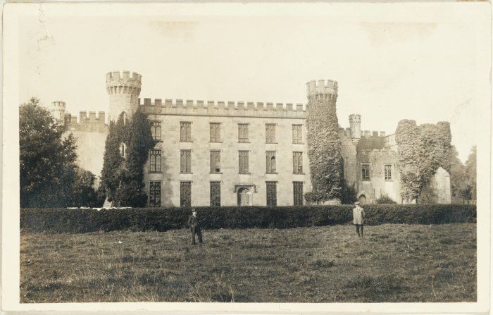
| Castle Oliver | The original Castle Oliver or Clonodfoy was the home of the Oliver family in the 18th and early 19th centuries. It was replaced by the present building in the mid 19th century. In 1814 Castle Oliver was occupied by George Fosbery who may have been employed by the Olivers. In 1837 Lewis described the castle as being in a very dilapidated state. It then belonged to R. O. Gascoigne of the county of York whose bailiff resided in it. The new building was designed by George Fowler Jones and built in the Scottish baronial style for the Oliver Gascoignes. At the time of Griffith's Valuation the castle was valued at £75 and the house at £48 and both were in the possession of Elizabeth O. Gascoigne and her brother-in-law, Frederick Charles Trench. The house was eventually inherited by Elizabeth's step-grandson, William Cosby Trench. He was the occupier in 1906 when it was valued at £125. Restored in the early 21st century it now provides self catering accommodation and is a venue for functions such as weddings. |
|
| Martinstown | Martinstown was the residence of M. Walsh in 1837. At the time of Griffith's Valuation this was a house on the Trench/Gascoigne estate valued at £10+ and inhabited by William O'Grady. Bence Jones refers to a modern house built in circa 1972 at Martinstown, Kilmallock. | |
| Millmount | Occupied by the Reverend Joseph Gabbett and held from Daniel Gabbett at the time of Griffith's Valuation, when the buildings were valued at £16. It is labelled Millmount on the First Edition Ordnance Survey Map and as Ardvullen on the later 25-inch edition of the 1890s. A house is still extant at the site. | |
| Ash Hill Towers | The residence of a branch of the Coote family in the 18th century, possibly held from the Barons Carbery. Ash Hill is referred to by Wilson as the seat of Chudleigh Coote in 1786. Bought by Eyre Evans from Chidley Coote in 1794 (see sale rental 6 July 1878). Eyre Evans held the property in fee throughout the first half of the 19th century. The Ordnance Survey Field Name Book describes this house as having "a most superb new front with towers at each end". At the time of Griffith's Valuation the buildings were valued at £50. Bence Jones writes that Ash Hill Towers became the residence of John Henry Weldon in the later 19th century. The Irish Tourist Association surveyor wrote in 1943 that the property was owned by Captain P.M. Lindsay, nephew of John H. Weldon, who bought the house from the Evans family in 1880. Still extant, this house is the centre of a stud. |
|
| Ahnagurra | Ahnagurra was the residence of Thomas T. Adams in 1837 and at the time of Griffith's Valuation, when the buildings were valued at £26. He held the property from Francis Coppinger. | |
| Ballynalacken | A house valued at £15 and occupied by George Gubbins who held it from Francis Coppinger at the time of Griffith's Valuation. It is no longer extant. | |
| Griston House | The residence of a branch of the Massy family, occupied by Frederick Massy in 1814. Described by Lewis in 1837 as the fine old family mansion of the Masseys. Fitzgerald writes that Charles Massy of Griston was a brother of Lord Massy and 1st Lord Clarina. At the time of Griffith's Valuation it was valued at £12 and occupied by Michael McMahon, who held it from Charles O'Brien Massy. | |
| Ryves Castle [Castle Jane] | Ryves Castle, previously known as Castle Jane, was the home of the family of this name in the 18th and early 19th centuries. It is referred to as Castle Jane by Wilson in 1786 when he notes it as the seat of Mr. Ryves. By the 1830s however William H. Ryves of Ryves Castle appears to have moved to live in Brighton, as the birth of many of his children is recorded in the Limerick newspapers as having taken place there. In 1826 Fitzgerald records Ryves Castle as the residence of John Lowe. Lewis referring to the parish of Knocklong, notes that Thaddeus R. Ryan was resident at Castle Jane and that there was a vault of the Lowe family located in the grounds of Ryves Castle, that family having previously been its proprietors. For the parish of Ballyscanlan he records Ryves Castle as the residence of P. [T?] Ryan. At the time of Griffith's Valuation the house was valued at £29 and occupied and held in fee by William H. Ryves. In 1906 it was valued at £31 and was occupied by Thomas J. Franks. Later owned by Mr D. Fleming, this house is now demolished. | |
| Ballynacourty | In 1837 and at the time of Griffith's Valuation occupied by Michael Burke. In the 1850s it was valued at £13 and held from the Honourable C.B. Wandesforde. | |
| Darragh House | The residence of Fred Bevan in the early 1850s, held by him in fee and valued at £12+. In the 1870s Hamilton Geale/Gale lived at Durragh Lodge. The house is now known as Darragh House and is still extant and occupied. Self catering accommodation is available, see www.darraghcottages.com. |

|
| Massy Lodge | This house is named Massy House on the first Ordnance Survey map and was the main residence of Lord Massy in the first decade of the 19th century. In 1814 Anglesborough was occupied by Hugh Toutstone [Touchstone]. Lewis describes Massy Lodge as the elegant residence of Lord Massy. At the time of the first Ordnance Survey Massy Lodge was the residence of Robert Harding. It was held by Lord Massy in fee at the time of Griffith's Valuation and valued at £24+. The partly demolished house is now owned by the Hanly family. |

|
| Janeville | A house located very close to the county Tipperary border, occupied by the Reverend R. Lloyd in 1837 and by Samuel R. Harding at the time of Griffith's Valuation. The buildings were valued at £17+ and held from Thomas L. Sadlier. | |
| Glenefy/Gleneefy | Built for George L. Bennett by Charles Frederick Anderson see http://www.dia.ie/works/view/256 The house is named on the first Ordnance Survey map as Gleneefy but on the later 25-inch map as Glenefy. In 1837 Castlecreagh was the residence of G. Bennett and at the time of Griffith's Valuation Castlecreagh, valued at £26 was held by George L. Bennett in fee. In 1906 occupied by William H.M. Bennett and still valued at £26. It is still extant. |
|
| Riversdale | Built by the Massys in the early 19th century and occupied by Hugh Massy in 1837 and held by him in fee at the time of Griffith's Valuation when the house was valued at £30+. Lynch writes that this house was bought from the Massy Dawsons by John Noonan in 1922, who ran it as a hotel. |
|
| Stagdale Lodge | A Massy house occupied by members of the Massy family from the late 18th century. It was the home of Hugh Massy, a younger brother of George Massy of Glenwilliam Castle, at the beginning of the 19th century. Held by W. Massy in 1837, Lewis records the "fine avenue of stately beech trees". William Massy was still resident at the time of Grifffith's Valuation holding the property from Hugh Massy. In 1906 occupied by Hugh H.G. Massy and valued at £30.10 shillings. | |
| Bosnetstown | The Bennett family were resident at Bosnetstown from the early 19th century. Charles Bennett of Bosnetstown was a coroner for county Limerick in the 1810s. Located on the estate of Lord Lisle this house was occupied by George W[heeler] Bennett in 1814 and 1837 and in the early 1850s by George Bennett. The property was valued at £14. In the 1870s George Wheeler Bennett of Kilfinane held 156 acres in the county. The Bennett also lived in other houses closeby at various times for example Kilfinane House. http://members.iinet.net.au/~nickred/trees/bennett.pdf | |
| Ballynahinch | A house valued at £11 occupied by Thomas Cleary at the time of Griffith's Valuation and held with 354 acres from the Trench/Gascoigne estate. Thomas Cleary of Ballinahinch owned 454 acres in county Limerick in the 1870s. A house is still extant at the site. | |
| Spa Hill | A home of the Oliver family, occupied by Charles Deane Oliver in 1814 and by William Oliver in 1837 and at the time of Griffith's Valuation. The buildings were valued at £23+ and William held them from the Trench/Gascoigne estate, with a corn mill. |

|
| Sunville | A residence of the Godsell family in the 18th century, it was still in the possession of James Godsill in 1814. Lewis writes that Sunville anciently belonged to the Godsall family but was "now" (1837) the residence of E. Sayers. Edward Sayers held it in fee at the time of Griffith's Valuation. Sunville/Sunvale was afterwards a residence of the Low family, being occupied in 1906 by Colonel John Low. Lithographs of this house and mill are included in the sale rental of 1853. The Irish Tourist Association surveyor wrote in 1943 that the house was owned by Mr John O'Donnell. He says that it was built in the early 18th century by the Cosby family from whom it passed to the Lowes. It is labelled Sunvale on the 25-inch Ordnance Survey map of the 1890s. The house is no longer extant. |
|
| Ballygrennan Castle | Granted to the Evans family under the Acts of Settlement. In the early 19th century the residence of William Creed. Described as "in ruins" on the 1st edition Ordnance Survey map. Some portions of the building remains though much of the stone has been removed. | |
| Ballywire | The demesne of this house straddled the border between counties Limerick and Tipperary. In 1826 Fitzgerald refers to the house having been "lately fitted up and furnished in a very tasteful manner". Godfrey Massey was resident at Ballywire in 1814. By 1837 it had become the home of John Bolton Massy who held the property in the 1850s from the Provost and Fellows of Trinity College, Dublin. It was valued at £40. This house is still a residence. |

|
| Knocktoran | This late 19th century seat of the Webb family is now a stud farm. Anna Thomasina Webb occupied the house in 1906 when it was valued at £32. Owned by Major S.N.C. Webb in 1943. It is still extant. |
|
| Garryspillane House | A mansion house valued at £16.15 shillings was located in this townland in 1906. It was occupied by Stafford Delmege, second son of the Reverend John Delmege, whose representatives owned 525 acres in county Limerick in the 1870s. A house labelled Garryspillane House is shown on the 25-inch Ordnance Survey Map of the 1890s. There is still an extant house at the site. | |
| Ballynacourty | Originally the home of the Dawson family, it passed by marriage to the Massy family and was the seat of the Massy Dawsons in the 18th and 19th centuries. Occupied by J. H. Massy Dawson in 1837 and owned by the estate of Reverend John M. Dawson in the early 1850s. It was held in fee and was valued at £75. In 1839 the Ordnance Survey Name Books describe it as "beautifully situated and in good repair, the residence of Rev. J.M. Dawson". In 1894 Slater refers to it as the seat of George Staunton King Massy-Dawson. This house was a ruin by the mid 20th century. |

|
| Mount Bruis | The Inventory of Irish Architectural Heritage dates this house from the mid 18th century. It was occupied by Doherty Esq in the 1770s and in 1786. The residence of Edmund Scully in 1814, Mrs Doherty in 1837 and Thomas Dwyer in the early 1850s. Dwyer held the property from Irwing Bagnell and the buildings were valued at £25. In 1840 the Ordnance Survey Name Books described it as "a very old building and in middling repair". It is still extant. |

|
| Woodville | Lewis records Matthew Gibbons [Givens?] as the occupier of this house. Mathew Givens was resident at the time of Griffith's Valuation and held the house valued at £15 from the estate of Reverend John M. Dawson. In 1839 the Ordnance Survey Name Books describe it as "in excellent repair and beautifully ornamented". It is still extant and occupied. |

|
| Ballyglass House (Clanwilliam) | Lewis records Mrs Slattery as resident at Ballyglass in 1837. In 1840 The Ordnance Survey Name Books refer to it as a house "in good repair, the residence of John Burke". It is recorded under both Clonpet and Cordangan parishes. By the mid 19th century it was the home of Thomas Mulcahy. The house was valued at £18.10 shillings and was held from Robert Maxwell. Buildings still exist at this location. | |
| Brookville | In 1840, the Ordnance Survey Name Books describe Brookville as "of very large dimensions, in very good repair, the residence of James Sadlier". He still lived at Brookville in the mid 19th century when the house was valued at £30 and held from James H. Smith Barry. This house, located on the south side of Tipperary town, is still a residence. |

|
| Scalaheen | In 1840 the Ordnance Survey Name Books describe Scalaheen as "a very large house pleasantly situated on a hill, the residence of Richard Sadlier". William Sadlier occupied this house which he held from Nicholas Sadlier at the time of Griffith's Valuation. It was valued at £30. This house, which was located on the outskirts of Tipperary town, no longer exists. | |
| Ballynacree House | A house valued at £10 and held from Samuel Dixon by Michael Manning in the mid 19th century. Ballynacree is still extant. |

|
| Mooresfort | The home of the Crosbie Moore family in the 18th and early 19th century, Wilson refers to Moore's-fort as "the handsome seat of Edward Moore" in 1786. Lewis records Maurice Crosbie Moore as resident in 1837. At the time of Griffith's Valuation Edward C. Moore was still in possession of Mooresfort. However it was advertised for sale in 1852 and sold to Charles Moore of county Antrim, who altered and remodelled the house, reducing it from a 3 storey to a 2 storey house. The house remained in the possession of this family into the 20th century. It is now the main residence on a working farm. |

|
| Ballinard | This house was the seat of the Chadwick family in the 18th and 19th centuries. The present house dates from the early 19th century and incorporates parts of an older building. John Chadwick was resident in 1814 and William Chadwick in 1837. In 1840 the Ordnance Survey Name Books note it as the seat of Ostin [Austin] Sadlier and describe the house as "a very large building in good repair". At the time of Griffith's Valuation. the house was valued at £33 and held from the Earl of Portarlington. The Chadwicks were still living at Ballinard at the beginning of the 20th century. |

|
| Damerville | Austin Cooper Chadwick, third son of John C. Chadwick, lived at Damerville in the 1830s. In 1840 the Ordnance Survey Name Books describe it as "a modern structure in good repair". By the time of Griffith's Valuation [his widow] Mrs Anne Chadwick was resident. The house was valued at £10 and held from the Earl of Portarlington. It is still extant. |

|
| Shrone Hill | Shrone Hill or Shronell House is a mid 18th century house. In 1786 Wilson describes it as "once a magnificent building of the late Mr. Damer, now belonging to Lord Milton and in ruins". It was occupied by the Sadlier family in the 18th and 19th centuries. The Ordnance Survey Name Books refer to it as the residence of William Sadlier in 1840. At the time of Griffith's Valution the house was valued at £20 and leased by Clement Sadlier from the Earl of Portarlington. It is still extant. |

|
| Damer's Court | In 1837 Lewis refers to this house as follows "built about a century ago by John Damer, passed to the Earl of Dorchester and then to Lady Caroline Damer his daughter and sole heir and is now the property of the Earl of Portarlington. The mansion was taken down in 1776". It is marked on Taylor and Skinner's map. In 1786 Wilson refers to it as "the very noble and beautiful seat of Lord Milton", On the 1st edition Ordnance Survey map it is labelled "Damerville Court [in ruins]". There is no trace of this house now. | |
| Ballykisteen House | Described by Lewis in 1837 as an "elegant modern building" situated on the Limerick road. The Ordnance Survey Name Books of 1840 refer to it as "the residence of Lord Stanley, pleasantly situated on rising ground and in good repair". In the early 1850s the house was valued at £50 and held in fee by Lord Stanley. It was later one of the homes of the O'Connor family. The original house no longer exists. Ballykisteen hotel and golfcourse are now located near the site. |

|
| Russelstown | At the time of Griffith's Valuation John Hewston occupied Russelstown House, valued at £20, and held from Lord Stanley. |

|
| Roesborough | Occupied in the 1770s by Sadler Esq. In 1786 Wilson states that it was the seat of James Roe. Occupied in 1814 and 1837 by James Roe and in the early 1850s by his son George who held the property in fee. The house was valued at £32.15 shillings. The representatives of Richard Sadlier were the tenants of Roesborough in 1873. This house is now a ruin. |

|
| Glenbrook Cottage | Thomas Holmes was leasing this property from the Massy-Dawson estate at the time of Griffith's Valuation when it was valued at almost £4. It is not named on the 1st edition Ordnance Survey map but appears as Glenbrook Cottage on the 25-inch edition of the 1890s. It is still extant and occupied. Local sources suggest that the original house dates to the seventeenth century and that the Holmes family called it Clydeingrove. |
|
| Cloverfield | In 1786 Wilson mentions a house called Cloverfield three miles beyond Caherconlish as the seat of Mr. Lloyd. A house named Cloverville is marked on the first edition Ordnance Survey map. On later maps a much larger building is marked. At the time of Griffith's Valuation valued at £9.5 shillings was vacant in this townland. Richard Laffan, a dairy farmer, is recorded as the immediate lessor. The National Inventory of Architectural Heritage dates the original building from circa 1830 with later 19th century additions. The house continues to be used as a residence. |

|
| Knockainy Cottage | Possibly located on the estate of the Earl of Kenmare who owned land in this parish in the mid 19th century. On the first edition Ordnance Survey map this building is named Knockainy Cottage. Later maps show a much larger building now known as Knockainy Stud. |

|
| Mount Blakeney | Mount Blakeney is south west of the town of Kilmallock and very close to the border between counties Limerick and Cork. No large house is marked in the townland of Mount Blakeney on the first Ordnance Survey map (Sheet 47). In 1786 Wilson refers to Mount Blakeney as the seat of Mr. Blakeney. At the time of Griffith's Valuation the townland was in the possession of Mrs. Blakeney Fitzgerald. In 2022 Mount Blakeney was offered for sale. |

|
| Kildromin | In 1786 Wilson refers to "Kildrummond" as the seat of Mr. Lloyd. At the time of Griffith's Valuation, a house in Kildromin townland, valued at almost £4 was being leased by James Fitzgerald from the Apjohn estate. There is still a substantial farm at the site. | |
| Kilteely House | In 1786 Wilson refers to Kilteely as the seat of Mr. McNamara. By the time of Griffith's Valuation, much of this townland is the property of John Ryan jnr. This may be the property occupied by Rev. John Madden and valued at almost £8. Kilteely is shown but not labelled on the 1st edition Ordnance Survey map and is labelled Kilteely House on the 25-inch edition of the 1890s. According to the National Inventory of Architectural Heritage it serves as the local Parochial House. |
|
| Sandymount (Cordangan) | In 1840 the Ordnance Survey Name Books refer to Sandymount House "in good repair", part of the estate of James Sadlier. By the time of Griffith's Valuation, it was being leased by F.J. Mansergh from the Smith-Barry estate and valued at £7 5s. Buildings are still extant at the site. | |
| Ballynilard Cottage | In 1840 the Ordnance Survey Name Books refer to Ballynilard Cottage as the residence of Robert Smithwick, "pleasantly situated and in good repair". At the time of Griffith's Valuation, the townland was part of the Smith-Barry estate. Robert Smithwick was leasing a house valued almost £10 while William Evans, MD, was leasing another house in the townland valued at £10 5s. Ballynilard Cottage is labelled Cottage on the later 25-inch map of the 1890s and a house still exists at that location. |