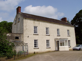
Friarsfield
Houses within 10km of this house
Displaying 54 houses.
Houses within 10km of Friarsfield
Displaying 54 houses.
| House name | Description | |
|---|---|---|
| Bansha Castle | The home of the O'Brien Butlers in the 18th century. In 1786 Wilson refers to Bansha as the seat of Mr.O'Brien. The residence of the O'Ryan family in the first half of the 19th century, occupied by Andrew O'Ryan in 1814 and Edmund O'Ryan in 1837. John Chaytor was resident fromn 1840 and into the early 1850s holding the buildings valued at £25 from Edmund O'Ryan. This property was advertised for sale in the early 1860s. The rental of 1866 describes this residence as containing " Four spacious reception rooms, six well ventilated bed rooms, bath room and servant's dormitory". In the 1870s Major John Lutman of Bansha Castle, who was married to an O'Ryan, owned 485 acres in county Tipperary and 94 acres in county Limerick. Bansha Castle was the home of Sir William Francis Butler in the early 20th century. The Russell family now offer luxury accommodation at Bansha Castle. see http://www.banshacastle.com/index.html |

|
| Lismacue | The seat of the Baker family in the 18th and 19th centuries, Lismacue was referred to by Wilson as the seat of Mr. Baker in 1786. It was occupied by William Baker in 1814 and by his nephew, Hugh Baker in 1837 when Lewis describes the house as a "handsome castellated mansion". The Ordnance Survey Name Books describe it as "lately erected...the property of John Charters" in 1840. The house was valued at £55 at the time of Griffith's Valuation. This property is still in the possession of a family member and may be rented for country vacations. http://www.lismacue.com/index.htm |

|
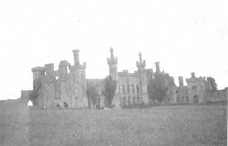
| Thomastown Castle | The original building was a two storey house of pink brick built in the 1670s by George Mathew with early 18th additions. Wilson decribed it in 1786 as "an ancient but handsome edifice". In the second decade of the 19th century it was enlarged and transformed into a Gothic castle, designed by Richard Morrison for the 2nd Earl of Llandaff. Viscount Chabot is recorded as the occupier in the mid 19th century. He held the property in fee and the buildings were valued at £100. Bence Jones writes that it later was in the possession of the Daly family but from the mid 1870s it began to decay. William Daly was the occupier in 1906 when the buildings were valued at £61. |
|
| Ballygriffen | Taylor and Skinner record the Earl of Clanwilliam as proprietor of Ballygrifffin, Golden, in the 1770s. In 1786 Wilson refers to two properties owned by the Earl in this area "on the left of Golden is Lisheen, a seat sometimes occupied by the Earl of Clanwiliam, contiguous to which is Ballygrifin, where his lordship has a very fine range of stables and other offices". The house now at Ballygriffin is a mid 19th century house incorporating the remains of a a tower house. Occupied by Edmond [Edward] Dalton in the mid 19th century when the buildings were valued at £16.10 shillings and held from Charles Bianconi. Edward Dalton's son John Edward Dalton of Golden Hills owned 161 acres in the 1870s. |

|
| Mount Bruis | The Inventory of Irish Architectural Heritage dates this house from the mid 18th century. It was occupied by Doherty Esq in the 1770s and in 1786. The residence of Edmund Scully in 1814, Mrs Doherty in 1837 and Thomas Dwyer in the early 1850s. Dwyer held the property from Irwing Bagnell and the buildings were valued at £25. In 1840 the Ordnance Survey Name Books described it as "a very old building and in middling repair". It is still extant. |

|
| Woodville | Lewis records Matthew Gibbons [Givens?] as the occupier of this house. Mathew Givens was resident at the time of Griffith's Valuation and held the house valued at £15 from the estate of Reverend John M. Dawson. In 1839 the Ordnance Survey Name Books describe it as "in excellent repair and beautifully ornamented". It is still extant and occupied. |

|
| Ballyglass House (Clanwilliam) | Lewis records Mrs Slattery as resident at Ballyglass in 1837. In 1840 The Ordnance Survey Name Books refer to it as a house "in good repair, the residence of John Burke". It is recorded under both Clonpet and Cordangan parishes. By the mid 19th century it was the home of Thomas Mulcahy. The house was valued at £18.10 shillings and was held from Robert Maxwell. Buildings still exist at this location. | |
| Brookville | In 1840, the Ordnance Survey Name Books describe Brookville as "of very large dimensions, in very good repair, the residence of James Sadlier". He still lived at Brookville in the mid 19th century when the house was valued at £30 and held from James H. Smith Barry. This house, located on the south side of Tipperary town, is still a residence. |

|
| Cordangan House | Cordangan was a Cooke family residence in the 18th and 19th centuries, occupied by John Cooke in 1814. The Ordnance Survey Name Books refer to it as being "in very good repair, the residence of J. Cooke". in the early 1850s it was occupied by Thomas Cooke. The property was held from the Smith Barry estate and the buildings were valued at £26. Slater refers to it as the residence of Horatio Townsend in 1894. In 1906 it was in the possession of Lord Barrymore and valued at £53. It is still extant. |

|
| Scalaheen | In 1840 the Ordnance Survey Name Books describe Scalaheen as "a very large house pleasantly situated on a hill, the residence of Richard Sadlier". William Sadlier occupied this house which he held from Nicholas Sadlier at the time of Griffith's Valuation. It was valued at £30. This house, which was located on the outskirts of Tipperary town, no longer exists. | |
| Chadville | A house valued at £11 occupied by William Ryan and held from Hugh B. Bradshaw in the mid 19th century. Later in the nineteenth century it was associated with Valentine Ryan, who held large estates in County Donegal and in Queen's County. This house is still in use as a residence. |

|
| Pegsborough House | In 1786 Wilson refers to Pegsborough as a seat of the Earl of Derby. Henry Smithwick was living at Pegsborough in 1814. By 1837 George Bradshaw was resident. The Ordnance Survey Name Books in 1840 refer to this house as the property of Lord Portarlington. In the early 1850s George Bradshaw held the property from Henry Smithwick. The buildings were valued at £23.5 shillings. A house is still extant at the site. | |
| Grantstown Hall | The present house is not marked on the first Ordnance Survey map circa 1840. A house in this townland, valued at £10.10 shillings at the time of Griffith's Valuation, was occupied by Charles Massy who held it from [his brother] Henry W. Massy. In 1894 Slater noted it as the seat of Gen. William Massy. The Massys continue to live at Grantstown until at least 1906. Still extant and occupied. |

|
| Bansha House | Bansha House is marked on the first edition Ordnance Survey Map circa 1840. It was the home of Robert Clarke, fourth son of the Reverend Marshal Clarke, in 1837. John Vincent occupied a house valued at £20 in this townland at the time of Griffith's Valuation. He held it from Richard Butler. The National Inventory of Architectural Heritage dates this house from about 1880. It now functions as a guest house. http://www.tipp.ie/banshahs.htm |

|
| Kilfeakle | A home of the Bunbury family in the mid 18th century and later of the Scully family. James Scully was resident at Kilfeacle in 1814. Mrs Scully, [widow of Denys Scully, son of James], was the occupier in 1837 and her fourth son Thomas was resident at the time of Griffith's Valuation. He held the property from the representatives of B. Bunbury. By the early 20th century Kilfeakle House was in ruins. | |
| Mountwilliam | This house was a Bunbury home in the late 18th century. Wilson refers to Mount-William as the seat of Mr. Bunbury in 1786. Jeremiah Scully was living at Mount-william in 1814. James Mahon was resident in 1837 and Denis Dwyer in the early 1850s. The property was held from the representatives of Benjamin Bunbury and the house was valued at £14. This house no longer exists. | |
| Kilshane/Arraghslea | Kilshane Cottage was occupied by Captain Blackmore in 1837 and noted by the Ordnance Survey Name Books as "the residence of Captain Blackmore, in excellent repair" in 1840. It was occupied by Henry Blackmore in the mid 19th century, when the house was valued at £11 and held from Simon Lowe. The Blackmores were related to the Lowes. This building is named Kilshane on the first edition Ordnance Survey map. Buildings in Kilshane valued at £12 were still in the possession of the Lowe family in 1906. This house later became known as Arraghslea and following a townland boundary change was located in the townland of Springhouse. |

|
| Kilshane/ Spring House | It is not clear where the McCarthy house at Springhouse was located but a building is marked on the first edition Ordnance Survey map as Spring House, later known as Kilshane. In 1786 Wilson refers to Spring House as the seat of Mr. McCathy. Thomas McCarthy resided at Springhouse in 1814. The present house was built in the 1820s by John Lowe and was designed by C. F. Anderson. It continued to be the home of the Lowe family throughout the 19th century. Lewis refers to Spring House the residence of J. Low. Simon Low held the property in fee at the time of Griffith's Valuation when the house was valued at £75. The Lowes were still resident in 1906. This house was renovated and restored in the early 21st century and now functions as a hotel. see http://www.kilshanehouse.ie/Contact.html |

|
| Lacken | John Smithwick was resident at Lacken in 1837 and by George Smithwick in the early 1850s and held from Miss Mary Sadlier. The buildings were valued at £11. A house is still extant at the site. | |
| Ballinaclogh | A house occupied by William Scully and held by him in fee at the time of Griffith's Valuation. The buildings were valued at £11. William Scully (born 1821) of Ballinaclough was the fifth son of Denys Scully of Kilfeakle. He owned 1,354 acres in county Tipperary in the 1870s. Occupied by T.A. Scully in 1906 and valued at £16. | |
| Castlepark House/ Mantle Hill | In 1786 Wilson refers to the seat of Mr. Alleyn on the left at the entrance to Golden. He may be referring to the early house at this site, shown as Castlepark House on the first edition Ordnance Survey map. By the early nineteenth century it was the home of the Creagh family. Richard Creagh was resident in 1814 and 1837 and Lawrence Creagh held the property from Kingsmill Pennefather at the time of Griffith's Valuation. The buildings were valued at £65. Later bought by the Scullys, when it became known as Mantle Hill. Occupied by Vincent Scully in 1906. The house is no longer extant. |
|
| Golden Hills | Leet records Henry White as the proprietor of Goldenville, Golden, in 1814. In 1837 Lewis refers to Golden Hills as the "castellated residence of H. White". Edmond [Edward] Dalton occupied this house in the early 1850s holding it from Henry White. It was valued at £25. By 1858 Thomas Judkin Fitzgerald was occupying Golden Hills or Golden Lodge which was advertised for sale in January 1858 and again in April 1878. In 1878 Golden Hills was described as a "large castellated building" with a drawing room opening into a conservatory, dining room and morning room, 8 bedrooms and a servants' hall. The Irish Tourist Association surveyor records that it was the residence of Thomas Judkin Fitzgerald, High Sheriff of county Tipperary in 1798, known as "Flogging Fitzgerald". In the early 1940s most of the house had disappeared or was incorporated into a modern farmyard. |

|
| Spring Mount | J. White was living at Spring Mount in 1837 and at the time of Griffith's Valuation Robert W. White was the occupier, holding the property from William Scully. The house was valued at £17. The Whites were still occupying Spring Mount in the 1870s. |

|
| Athassel | James Scully was occupying this house at the time of Griffith's Valuation. He held it from Richard Creagh and the buildings were valued at £30. This house is still a residence. |
|
| Rathcloheen | Rathcloheen was the home of John Mathew in the first half of the 19th century. The house is situated very close to Thomastown Castle. At the time of Griffith's Valuation John Mathew held Rathcloheen from Lynn Carew and the buildings were valued at £20. "Burke's Irish Family Records" refers to John Smithwick of Rathclogheen, county Tipperary who married Cherry Pennefather in 1823. This house is well preserved and is still used as a residence. |

|
| Ballinard | This house was the seat of the Chadwick family in the 18th and 19th centuries. The present house dates from the early 19th century and incorporates parts of an older building. John Chadwick was resident in 1814 and William Chadwick in 1837. In 1840 the Ordnance Survey Name Books note it as the seat of Ostin [Austin] Sadlier and describe the house as "a very large building in good repair". At the time of Griffith's Valuation. the house was valued at £33 and held from the Earl of Portarlington. The Chadwicks were still living at Ballinard at the beginning of the 20th century. |

|
| Damerville | Austin Cooper Chadwick, third son of John C. Chadwick, lived at Damerville in the 1830s. In 1840 the Ordnance Survey Name Books describe it as "a modern structure in good repair". By the time of Griffith's Valuation [his widow] Mrs Anne Chadwick was resident. The house was valued at £10 and held from the Earl of Portarlington. It is still extant. |

|
| Shrone Hill | Shrone Hill or Shronell House is a mid 18th century house. In 1786 Wilson describes it as "once a magnificent building of the late Mr. Damer, now belonging to Lord Milton and in ruins". It was occupied by the Sadlier family in the 18th and 19th centuries. The Ordnance Survey Name Books refer to it as the residence of William Sadlier in 1840. At the time of Griffith's Valution the house was valued at £20 and leased by Clement Sadlier from the Earl of Portarlington. It is still extant. |

|
| Damer's Court | In 1837 Lewis refers to this house as follows "built about a century ago by John Damer, passed to the Earl of Dorchester and then to Lady Caroline Damer his daughter and sole heir and is now the property of the Earl of Portarlington. The mansion was taken down in 1776". It is marked on Taylor and Skinner's map. In 1786 Wilson refers to it as "the very noble and beautiful seat of Lord Milton", On the 1st edition Ordnance Survey map it is labelled "Damerville Court [in ruins]". There is no trace of this house now. | |
| Ballykisteen House | Described by Lewis in 1837 as an "elegant modern building" situated on the Limerick road. The Ordnance Survey Name Books of 1840 refer to it as "the residence of Lord Stanley, pleasantly situated on rising ground and in good repair". In the early 1850s the house was valued at £50 and held in fee by Lord Stanley. It was later one of the homes of the O'Connor family. The original house no longer exists. Ballykisteen hotel and golfcourse are now located near the site. |

|
| Russelstown | At the time of Griffith's Valuation John Hewston occupied Russelstown House, valued at £20, and held from Lord Stanley. |

|
| Barnlough | This house was a Smithwick family home in the 18th and early part of the 19th centuries, occupied by Thomas Smythwick in 1814 and by P. Smithwick in 1837. Barnlough was held by the Earl of Portarlington in fee at the time of Griffith's Valuation, when the buildings were valued at £11.10 shillings. It is no longer extant. | |
| Ashgrove | In 1786 Wilson refers to Ashgrove as the seat of Mr. Ash. At the time of Griffith's Valuation Ashgrove House was valued at £14.10 shillings and occupied by John Henry Ashe who held it from his brother Trevor Lloyd Ashe. A lithograph of Ashgrove is included in the Ashe sale rental of 1854. It was bought by Charles Moore of Mooresfort. Ashgrove was offered for sale again in 1864. It was held on a lease dated 1815 from Trevor Lloyd Ashe to Southwell Moore for 3 lives renewable for ever. Lyons writes that Southwell Mulcahy was resident from 1858. This house is still in use as a residence. |

|
| Castle Mary | Lewis describes Ashgrove Castle or Castle Mary, the residence of the Reverend Trevor Lloyd Ashe, Lord of the Manor of Bansha, as a "castellated mansion in the Italian style of architecture, situated at the base of the Galtee mountains, 4,000 acres of which are attached to the estate". This house is marked on the first edition Ordnance Survey map. In 1840 the Ordnance Survey Name Books refer to it as the property of T.L. Ashe "of modern construction but in very bad repair". It is recorded as "in ruins" in the later 25 inch map of the 1890s. Land clearance has taken place in the area and nothing remains of Castle Mary. | |
| Ballydavid | G. Baker was resident at Ballydavid in 1837 and in the early 1850s when the house was valued at £13.10 shillings and held from the Reverend George Cole Baker. In 1786 Wilson refers to Ballydavid as the seat of Mr. Baker. In 1840 the Ordnance Survey Name Books had noted that the house was in bad repair though the demesne was described as "neatly ornamented". This house no longer exists. | |
| Greenane | The Manserghs were residing at Greenane from the mid 18th century. Wilson, writing in 1786, refers to the house as the seat of Nicholas S Mansergh. In 1814 John Mansergh was the occupant and in 1837 it was the home of his son, Richard Southcote Mansergh. In the mid 19th century the house was valued at £35 and held from Lady Osborne. In 1894 Slater refers to it as the seat of Lt. Col. M. Tynte. The house is still occupied by a member of the Mansergh family, Philippa Mansergh, and her husband, John Wallace. |

|
| Roesborough | Occupied in the 1770s by Sadler Esq. In 1786 Wilson states that it was the seat of James Roe. Occupied in 1814 and 1837 by James Roe and in the early 1850s by his son George who held the property in fee. The house was valued at £32.15 shillings. The representatives of Richard Sadlier were the tenants of Roesborough in 1873. This house is now a ruin. |

|
| Kingswell House/Sadleirswells | Kingswell was a Lovett property in the 18th and early 19th century.The home of a branch of the Sadlier family in the 19th century, labelled on the 1st edition Ordnance Survey map as Sadleirswells House and on the later 25-inch edition as Kingswell House. In 1840 the Ordnance Survey Name Books record that they were seeking the opinion of the then owner William Sadlier as to the name under which the house should appear. Occupied by Richard Sadlier in 1814, by W. Sadlier in 1837 and held by Richard Sadlier in fee at the time of Griffith's Valuation, when the house was valued at £35. Home of a branch of the Massy family in the second half of the 19th century. The sale rental of January 1854 shows that the house was leased to John Massy on 23 January 1852 by Robert W. R. Sadleir for the life of John Massy or 31 years. This house is now demolished although yard buildings and garden follies remain in existence. |

|
| Dundrum | Dundrum was the seat of the Viscounts Hawarden in county Tipperary in the 18th and 19th centuries. The Ordnance Survey Name Books mention that the demesne was well-planted in 1840. Dundrum was held in fee by Viscount Hawarden and valued at £85 at the time of Griffith's Valuation. The Earl de Montalt was still resident in 1906 when the house was valued at £85. The Irish Tourist Association Survey states that it was bought from the Land Commission in 1908 and became St Michael's Presentation Convent. This early 18th century Palladian house now functions as a hotel located in the grounds of the Tipperary golf club. |
|
| Kilmore | The National Inventory of Architectural Heritage dates this house from the early to mid 18th century and the Wayland family were resident at this time. Austin Cooper was living at Kilmore in 1837 and at the time of Griffith's Valuation Samuel Cooper was the occupier. He held Kilmore from the Earl of Normanstown and the buildings were valued at £16. This house is still occupied and part of a working farm. |
|
| Ballywalter | F. V. Wayland was resident at Ballywalter in 1837. Francis Wayland of Ballywalter was murdered in 1838 on his way to a fair. William Weyland was living at Ballywalter in the mid 19th century, when the house was held from William Cooper and valued at £12.5 shillings. The Waylands and Coopers were related. This 18th century house is still in use as a family residence. |
|
| Greenfield | Colonel W. Purefoy was resident at Greenfield in 1837. The Ordnance Survey Name Books refer to Greenfield as "a house in a small but well wooded demesne". By the early 1850s Edward Bagwell was the occupier. He held the property in fee and the house was valued at £27.15 shillings. Wilfred B. Purefoy occupied Greenfield in 1906 when it was valued at £38. 10 shillings. It is still extant. |
|
| Philipston | In 1840 the Ordnance Survey Name Books refer to "Phillipstown" as "a house in a small demesne". It was the residence of Hugh Brady Bradshaw in the mid 19th century, held by him from the Reverend William Guinness and valued at £16.15 shillings. This house is still extant and lived in. |
|
| Aherlow Castle | This early 19th century building was the residence of James A. Butler in the 1830s. In 1840 the Ordnance Survey Name Books note that it was the residence of the parish priest of Templeneiry. The Reverend William Kane was resident in the early 1850s when the buildings were valued at £9.15 shillings and held from James A. Butler. Aherlow Castle was later the property of the Moores of Mooresfort. Count Charles Moore was the occupier in 1906 when the buildings were valued at £20. It is now a ruin. |

|
| High Park | The Reverend John Hunt was resident at High Park in 1814 and in 1837. By the time of Griffith's Valuation his son Vere Hunt was the occupier. The property was held from Richard Beere and the buildings were valued at £15. High Park is still extant and, in 2012, was offered for sale. |
|
| Cappagh House | Vere Hunt was living at Cappa in 1814 and Mrs [Fitzmaurice] Hunt in 1837. Arthur Hewlett was the occupier in the mid 19th century holding the property from De Vere Hunt. The buildings were valued at £26.25 shillings. Godfrey Massy Hunt of the Friarstown family was resident in the later 19th century. This house belonged to Mr Griserood in the early 1940s. A house is still extant at this location. | |
| Rathneaveen | No house is named on the first edition Ordnance Survey map for this townland, however later maps show Rathneaveen House. It was built in the mid 19th century as Michael Ryan occupied a house valued at £10.15 shillings in this townland at the time of Griffith's Valuation. Michael Ryan of Rathneaveen is recorded in the 1870s and the house is still extant. | |
| Cluen House | An 18th century house originally known as Mount Kennedy. This house valued at £15 was being used as an auxiliary workhouse in the mid 19th century. It was held by John Kennedy from Thomas Slattery. In 1906 Lord Barrymore is recorded as the occupier and the building were valued at £28+. |

|
| Castle View | A house valued at £10 was occupied by Edmond Dalton in the mid 19th century. It was held from Colonel William Dickson. A building is marked on the first edition Ordnance Survey map at this location. A larger building on later maps is named Castle View. Buildings are still extant at the site. | |
| Cahervillahowe | A house built post Griffith's Valuation by the Massy family. Cahervillahowe was sold to Mr Harris in the early 20th century. It is now a stud. |

|
| Athasselabbey | A house occupied by William Dalton and held from Francis Green in the mid 19th century. The house was valued at £12+. It is still occupied. |

|
| Springfield House (Tipperary) | In 1786 Wilson refers to Springfield as the seat of Mr. English. By the time of Griffith's Valuation, the townland was part of the Smith-Barry estate and the house was valued at almost £4. It was occupied by Nicholas Sadlier at the time. A subtantial farm occupies the site now. | |
| Sandymount (Cordangan) | In 1840 the Ordnance Survey Name Books refer to Sandymount House "in good repair", part of the estate of James Sadlier. By the time of Griffith's Valuation, it was being leased by F.J. Mansergh from the Smith-Barry estate and valued at £7 5s. Buildings are still extant at the site. | |
| Ballynilard Cottage | In 1840 the Ordnance Survey Name Books refer to Ballynilard Cottage as the residence of Robert Smithwick, "pleasantly situated and in good repair". At the time of Griffith's Valuation, the townland was part of the Smith-Barry estate. Robert Smithwick was leasing a house valued almost £10 while William Evans, MD, was leasing another house in the townland valued at £10 5s. Ballynilard Cottage is labelled Cottage on the later 25-inch map of the 1890s and a house still exists at that location. |