Browse Houses
Search Results: Returned 5926 records. Displaying results 5601 – 5700
| House name | Description | |
|---|---|---|
| Torc Cottage | At the time of Griffith’s Valuation, Henry Herbert was leasing a property at Torc, valued at £39, to Sir Thomas Herbert. Lewis refers to it as the residence of Capt. Herbert in 1837 while Leet mentions it as the seat of Charles Herbert in 1814. In 1906 it was part of the Guinness estate and valued at £11 10s. Bary states that Torc Cottage was a handsome property surrounded by plantations. McCoole claims that Henry Arthur Herbert had built Torc Cottage for his mistress. The building is no longer extant. | |
| Torc View (Torc View Hotel) | Jeremiah Hurley was leasing a hotel valued at £40 from the Gallway estate at the time of Griffith’s Valuation. This was the Torc View Hotel. Horgan states that the building was later purchased by the Loretto Sisters and opened as a boarding school. It is labelled Loretto Convent on the 25-inch map of the 1890s. The site is now occupied by town houses. | |
| Tore | This house is named Toor on the first edition OS map and Torr on the 25 inch map. Located a short distance south east of Tyrrellspass, it was a two-storey, five-bay 18th century house, built by the Pilkington family and marked on the Taylor and Skinner map of the late 1770s. Henry Pilkington of Tore was a subscriber to Lewis’ Topographical Dictionary. The house was occupied by him at the time of Griffith’s Valuation (publ. 1854). Valued at £25 it was held from Charles B Marlay. Henry Mulock Pilkington of Tore owned 1,683 acres in county Westmeath in the 1870s. The house was burnt in the early 1920s and is now a ruin. | |
| Toureen | The first edition Ordnance Survey map marks Toureen House, later maps show a house located a short distance to the south west. Leet and Lewis records Denis O'Meagher as resident at Toureen. This may be the dairy house and offices recorded in Griffith's Valuation and valued at £3.5 shillings held by Stephen O'Meagher in fee. The 25-inch map of the 1890s indicates Tooreen House and a house and substantial farm are still extant at this site. | |
| Toureen Lodge/Ashbourne | At the time of Griffith's Valuation the Reverend Robert Bury was occupying a house in this townland valued at £17 and held from the Earl of Bandon. It is labelled Toureen Lodge on the 1st edition Ordnance Survey map and as Ashbourne on the 25-inch edition of the 1890s. In the twentieth century it became famous for its well-known gardens, laid out by Richard H. Beamish. |

|
| Toureen Wood House | This house located on the northern fringe of Toureen wood was the home of Philip Maguire in the second half of the 19th century. The site of this house is located near a building marked on the first edition Ordnance Survey map as Maguire's Castle. The sale rental of 1875 refers to a new and comfortable dwelling house on the lands of Toureen, containing 2 good reception rooms, 7 bedrooms. a large kitchen and store room, dairy and pantries. The house was in the owner's possession. A house in the townland of Toureen valued at £7.5 shillings was held in fee by Philip Maguire in the mid 19th century. Lewis records a house known as Kilmoylermore, the residence of "the late Constantine Maguire, Esq." | |
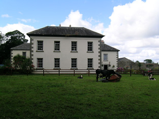
| Tourin and Tourin Castle | Tourin House was owned by Sir Richard Musgrave at the time of Griffith's Valuation, when it was valued at £41 10s. An earlier house, attached to Tourin Castle, is located nearby [X095965]. In 1850 it was valued at £49. In 1837, Lewis refers to this earlier Tourin House as the seat of Sir R. Musgrave, "composed partly of an ancient castle, commanding extensive and picturesque views".In 1906 the larger house had a valuation of £64 while the other buildings were valued at almost £10. The Musgrave estate still owned the properties. The ITA survey of the 1940s noted "Toureen" as the resident of Captain Jamison, formerly the property of the Musgraves. Both houses are still extant and occupied. |
|
| Tourin Castle Farm | This property, valued at £3 in 1851, represents the original Musgrave property and attached to the ruins of Tourin fortified house. Smith refers to a castle at Tourin, owned by John Reeves Nettles and formerly in the hands of the Roches. |
|
| Tournore House | In 1851, Beresford Boate was leasing this property from George Boate when it was valued at £18. Lewis refers to it as the seat of B. Boate in 1837. A house is still extant at the site though extensive modern development has taken place in the area. |
|
| Tower Hill | At the time of Griffith's Valuation, Richard Gardiner was leasing a property valued at £14 at Carrowkeel, barony of Tirerrill, from Viscount Lorton's estate. He was also renting over 400 acres. McTernan indicates that the family held property in the area since the mid eighteenth century. The original house was damaged by fire in the 1960s but another was built at the site and is still in the possession of the Gardiner family. | |
| Towerhill | A late 18th century house, occupied by the Blakes until the mid 20th century, now a ruin. 1n 1894 Slater refers to it as the seat of Colonel Maurice Blake. It was valued at £60 at the time of Griffith's Valuation, when it was occupied by Valentine O'Conor Blake. |
|
| Towerhill | This property was the original residence of the Lloyd family where they settled in the 17th century. It passed to William, second son of Reverend Thomas Lloyd of Towerhill. Occupied by William's son, Reverend Rickard Lloyd, in 1814. The buildings were valued at £31 at the time of Griffith's Valuation when William Lloyd was the occupier. The property was held from the Stafford O'Briens. Purchased by the Devanes at the end of the 19th century, the house is now in ruins. |
|
| Towermore | The home of Mrs Maria Oliver in 1837 but leased to Frederick C. Hayes in the early 1850s. The house was valued at £45. Maria was the widow of Charles S. Oliver of Inchera and a daughter of A. Morris of Dunkettle. A. Morris Oliver is recorded as a subscriber to Lewis ''Topographical Dictionary'' published in 1837 but is not mentioned in Burkes. Earlier, in 1786, Wilson refers to Tormore as the seat of Mr. Connor. This house was not occupied at the end of the 20th century although still extant. | |
| Trabolgan | Home of the Roche family for over three centuries. Held by Edmund Burke Roche in the mid 19th century and valued at £100. In 1912 acquired by the Clarke family, owners of the tobacco company in Bristol, manufacturers of Players cigarettes. Owned by the Clarkes until the 1940s when purchased by the Land Commission. The Irish Tourist Association survey noted that it was for sale in 1942. The house was demolished in 1982 and the demesne is now an activity holiday centre, see http://www.trabolgan.com/Home.aspx |
|
| Tracton Abbey | Denis Coveney was leasing this property from Achilles Daunt at the time of Griffith's Valuation, when it was valued at almost £9 with an adjacent mill valued at £11. Buildings are still extant at the site. | |
| Tracton Cottage | Achilles Daunt was leasing this property to Richard Hungerford at the time of Griffith's Valuation, when it was valued at £7. A house still exists at the site. | |
| Trafalgar Lodge | Described in the sale advertisement of 1866 as a commodious dwelling in the cottage style on the seashore, containing 'good parlour, four bedrooms, with coach house, stabling, piggery and other useful offices, the entire forming a square and enclosing a spacious yard'. The occupant was James Louden and the house had formerly been the residence of Captain Butcher of the Mayo Rifles. In 1874 the interest of Bridget Hastings in Trafalgar Lodge was advertised for sale in the Landed Estates' Court. | |
| Tralee | At the time of Griffith's Valuation, Francis Crumpe was leasing a property, valued at £31, at Denny St., Tralee, from John Donovan. [Grid Reference is approximate]. | |
| Tralee Castle | In 1786 Wilson writes "at Tralee is a castle in tolerable preservation, formerly one of the castles of the Earls of Desmond, granted by Queen Elizabeth to Sir Anthony Denny, and now the seat of his descendent, Sir Barry Denny". In 1943 the Irish Tourist Association Survey mentions that the last reconstruction of the building occurred in 1802. Bary writes that, after the Act of Union, the Denny family spent more time in England and the castle fell out of use and was eventually demolished and the stones used for other buildings. | |
| Trantstown | A Trant home in the 18th century, occupied by Mrs Pepper in 1837 and by James Barry in the early 1850s. He held the house valued at £8+ from Lady A.H. Fitzgerald. Buildings are still located at this site. | |
| Traverston | Traverston was the seat of the Going family in the 18th and 19th centuries. In 1786 Wilson refers to it as Trevor's-town, the seat of R.Going. It was the residence of Thomas Going in 1814 and 1837. The Ordnance Survey Name Books describe it as "a splendid residence" in 1840. In the mid 19th century Caleb Going occupied the house and held the property in fee. The buildings were valued at £52+. Still valued at £52 and occupied by John R. Lloyd in 1906. John R. Lloyd was the son of Anne, daughter of Robert Going of Cragg, Newport, who, in 1828, married Edward Lloyd of 12 Upper Mount Street, Dublin. John R. Lloyd died unmarried in 1910 and left Traverston to his niece, Ann Norris. This house is now demolished. see http://www.glendafae.com/histories/Going%20of%20TRAVERSTON.pdf | |
| Trawnahaha | Elizabeth Vickery was leasing this property on Whiddy Island from the Earl of Bantry's estate in 1852 when it was valued at £14. It is not named on the 1st edition OS map and the grid reference is approximate. | |
| Trawnamaddree | Cornelius Rohane was leasing this property from the Bantry estate in 1852 when it was valued at £10. It is not labelled on the 1st edition Ordnance Survey map and the grid reference is approximate. | |
| Treanlaur House or Lodge | At the time of Griffith's Valuation the house at Treanlaur was leased by Peter Denis Browne from the Westport estate and valued at almost £9. It was occupied by Charles Henry Laprimaudaye in the 1870s. Treanlaur is still extant. |
|
| Treantagh (Raphoe North) | Henry S. Hamilton was leasing this property from the Abercorn estate at the time of Griffiths Valuation in the 1850s, when it was valued at £25. |
|
| Treel House | William Atkinson was occupying Treel House at the time of Griffiths Valuation in the 1850s, when it and the adjacent mill were valued at £28. The National Built Heritage Service suggests the house was built c.1830. In 1839 the original Valuation Books, however, stated that at that time no house in the townland had a valuation of greater than £5 suggesting that Treel House was enlarged after that date. The Ordnance Survey Name Books noted in 1835 that the townland was then the property of Mr. Fox. Treel is still extant though not in use. |
|
| Triernearagh House | Edmond Walsh was leasing this property from the estate of Lady Burghersh at the time of Griffith's Valuation, when it was valued at £10 15s. | |
| Trinaderry | A house erected in the 1870s as the residence of Andrew Enright. It is labelled Trinaderry House on the 25-inch edition Ordnance Survey map of the 1890s. A house and farm are still extant at this site. | |
| Tristaun | At the time of Griffith's Valuation, Simon Sellers was leasing a property valued at £8, including a mill, from the Earl of Clancarty's estate. | |
| Tristernagh House | Described as an imposing and dramatic ruin with an interesting and varied history Tristernagh was originally an important Augustinian Abbey, founded c. 1200 by Geoffrey de Costentin (boi). After the dissolution of the monasteries and abbeys it was granted to the Piers Family, Elizabethan settlers. In 1783 Sir William Pigot Piers turned part of the building into a residence, which is named as Tristernagh House on the first edition OS map. It was unoccupied in 1814. A new house/cottage was built to the north of the abbey in the early nineteenth-century which is marked on the first edition OS map (N332 616). It is not clear which of these houses Lewis is referring to as the seat of Sir John Piers Bt in 1837. The 25 inch map of the early 20th century named this later building as Tristeragh House, while the original Tristeragh House at the abbey site was a ruin. Woods writes that the ‘late J Eivers Esq, J.P., lived for years in the cottage built by the late Sir John Piers’ while the mansion built by Sir Pigot William Piers in 1783 was ‘a crumbling ruin’. At the time of Griffith’s Valuation (publ. 1854) James Evers was recorded as the occupant of a house at Tristernagh valued at £10 held from Hamilton Geale. Shepherd Patrick Garry with family members was living here in 1901 and 1911. They held the house from Colonel John R Malone. The house is still extant. |
|
| Tromra | A house situated just south of the village of Quilty held from the Mahons. At the time of Griffith's Valuation this house was occupied by Admiral Sir Burton Macnamara baronet, the sixth son of Francis Macnamara of Doolin. It was valued at £18. A house of £9 valuation across the road from his residence was known as Tromra Lodge and was occupied by Lieutenant J. Morris of the Royal Navy at this time, grid reference R019 742. Neither house exists any longer. | |
| Tromra House | Tromra was being leased by Wiilliam Riggs from the Pakenham estate at the time of Griffiths Valuation in the early 1850s when it was valued at £13. The Valuation Office Books of 1839 indicate Mrs. Mary Anne Riggs was occupying a property valued at £10 at that time. Tromra is still extant and occupied. |
|
| Trough Cottage | Trough Cottage was occupied by William Walsh who held it from John Carroll at the time of Griffith's Valuation. It was valued at £16. Weir writes that this was the home of the Misses Bentley in the early 20th century. | |
| Trough House | Trough Castle in the townland of Trough is marked as "in ruins" on the first Ordnance Survey map 1842. Weir writes that Dr Elliott O'Donnell who inherited the county Clare property from Sir Charles O'Donnell in 1870 probably built Trough House in the townland of Roo West. Roo Cottage is marked on the first Ordnance Survey map. | |
| Tuam House | Located on the Saunders estate, outside the village of Blacklion, the present house replaced a former building marked on the first edition six inch Ordnance Survey map (publ. 1837). The Hassards lived at Tuam in the 18th century. Griffith’s Valuation records Hugh Bracken as the occupier, when the building was valued at £5. Hugh married Elizabeth Copeland and died in 1861. In 1876, James Bracken of Tuam House owned 51 acres county Cavan and 1,268 acres in county Fermanagh. Members of the Bracken family were resident at Tuam throughout the 20th century. The name of this house is sometimes spelt Toam. It is well maintained and occupied. |
|
| Tubbrid | Laurence Walsh occupied a house valued at £11.10 shillings and held from Lord Waterpark in the mid 19th century. This house still functions as a farm house. |
|
| Tubbrid (Lismore) | In 1851 this property was held in fee by Townsend Keily and valued at £23 10s. The property is still extant and part of a large farming enterprise. | |
| Tubbrid House | At the time of Griffith's Valuation, John M. Hickson was occupying Tubbrid House, parish of Templenoe, valued at £9. Bary states that the house was built by the [O]'Mahony-Hickson family. There is still an occupied house at the site though it may have been altered. . | |
| Tubrid House | George Gunn was leasing this property to Henry Hilliard at the time of Griffith's Valuation, when it was valued at £22 10s. Lewis recorded Tubrid as the seat of J. O'Connell.The Ordnance Survey Name Books indicate that this townland was owned by John O'Connell of Grenagh, Killarney and that John Sullivan of Tubrid was his agent in the 1830s. The house was occupied by Capt. Henry Hilliard at that time. In 1814, Leet noted the house as the seat of Townsend Gunn. Bary states that Tubrid House was built by the Crosbie family in the mid-eighteenth century and resided in by several generations of that family. The late eighteenth century owner, John G. Crosbie, was involved in a duel in which Sir Barry Denny was killed. A year later Crosbie himself died in mysterious circumstances. The house afterwards was owned by the Gunn and Hewson families. It is no longer extant. | |
| Tudenham Park/Rochfort | Rochfort later known as Tudenham Park was a seven-bay three-storey over basement country house, built in the early 1740s for George Rochfort, a brother of Robert Rochfort of Belvedere House 1st Earl. Like Belvedere it was designed by Richard Castle but was a much larger edifice. In 1837 Lewis describes Col Rochfort seat as ‘one of the finest mansions in the county’. The house was sold about this time to Sir Francis Hopkins Bt. He was resident at the time of Griffith’s Valuation (publ. 1854) when the house was valued at £90. Following his death in 1860 the property passed to his sister Anna Maria Tottenham who changed its name to Tudenham. It remained in Tottenham ownership into the 20th century, Charles Loftus Tottenham being the occupant in 1906, holding it with 440 acres of untenanted land. Deroofed in the 1950s it is now a fine ruin. |
|
| Tulla | Tulla House was the home of the Carroll family in the 19th century. William Carrol was resident in 1814 and Major General Sir Parker Carrol in 1837. Captain W. H. Carrol held the house valued at £20+ and townland in fee at the time of Griffith's Valuation. The house valued at £18 was still occupied by the Carrols in 1906. A house is extant at the site. | |
| Tullaghan | The ruins of Tullaghan House are marked on the 1st edition 6 inch Ordnance Survey map (1836). It was located on the estate of Lord Rossmore. Lewis writes in the 1830s that Tullaghan belonged to the Reverend Sir Thomas Forster Bart. ‘whose family formally resided here’. By the time of Griffith’s Valuation a herd’s house had been erected close by. It is named Tullaghan House on the 25 inch map (surveyed 1908). | |
| Tullaghan House | At the time of Griffith's Valuation Tullaghan House was in the possession of Joseph P. Tynte who was leasing it from Col.White's estate. Subsequently it became a residence of the Dickson family. It is still extant. |
|
| Tullagreen | Occupied by Robert Martin in 1814 and by Hughes Martin in 1837. The house was recorded as unoccupied at the time of Griffith's Valuation. Hughes Martin was the immediate lessor and the house was valued at £19+. |

|
| Tullahedy | Dominick Meade of Tullaheady, county Tipperary, died in 1717. Edwin Sadleir held a house valued at £15+ and 64 acres at Tullahedy from John O'Dwyer at the time of Griffith's Valuation. By 1906 Tullahedy valued at £16 was occupied by the representatives of Thomas J.R. Miller who held over 500 acres of untenanted land there. The Riggs Millers are still resident at Tullahedy. The Ordnance Survey Name Books record the existence of Tullahedy Old House, "almost in a state of ruins, occupied by a herdsman, but formerly a good dwelling house occupied by the Tumpane family". This property is shown on the 1st edition Ordnance Survey map at R841771. | |
| Tullamain Castle | Tullamaine Castle was the home of John Power, father of the 1st Sir John Power, Baronet. Leet records J.D. Scully as resident at Tullaghmain-castle, Fethard, in 1814. This was James Scully (1779-1853), fourth son of Jeremiah Scully of Silverfort. By 1837 Lewis records John Maher as resident though the Ordnance Survey Name Books in 1840 refer to the proprietor as a Mr. Walsh. By the time of Griffith's Valuation Maher is recorded as holding the property in fee. The buildings were valued at £44.16s. By the mid 1870s Tullamaine Castle belonged to Henry Maynard Harding who advertised it for sale in July 1880. Slater still refers to it as his property in 1894. Dr M.J. Barry was resident at Tullamain in 1906. The castle was burnt in the early 1920s but rebuilt and is still a country residence. In the early 1940s C. A. Vigours was resident. |
|
| Tullamore House | Sir John Benn-Walsh was leasing this property to Laurence Buckley at the time of Griffith's Valuation, when it was valued at £12 10s. In 1814 Leet refers to it as the residence of Mrs. Julian. Wilson writing in 1786, mentions Tullamore as the seat of Rev. Mr. Julian. In 1837 Lewis noted it as the seat of C. Julian. Bary writes that it was a house mostly associated with the Julian family. It was derelict at the end of the twentieth century. | |
| Tullamore Park | A late 18th century house built for Edward Finch. It was the seat of the Finch family in the 19th century, occupied by William Finch in 1837 and at the time of Griffith's Valuation, when the house was valued at £27 and held in fee. Sold in the early 20th century to the Kennedy family. This house is still in use as a residence. |
|
| Tullig | Tullig, located on the Tierney estate and valued at £15.15 shillings, was occupied by Richard Hutch in the early 1850s. The Irish Tourist Association Survey noted that it had belonged to Lord Broghill before the 1641 rebellion and was later granted to the Percevals. It was the residence of John Waterson in the 1940s. It is no longer occupied. |

|
| Tullig | Henry Leader of Tullig died in 1834 and the Leader interest in this property came to an end. James Nash (died 1849) of Rockfield, Kanturk and of Tullig House, Millstreet is recorded in ''Burke's Irish Family Records''. At the time of Griffith's Valuation Tullig, valued £20 was occupied by the Reverend Charles Mangan and held from Jonas Morris. |
|
| Tullig House | Henry Herbert was leasing this property to William England Young at the time of Griffith's Valuation, when it was valued at £7. In the 1830s, the Ordnance Survey Name Books describe Tullig as "a large house, two stories high, with offices and a garden, the residence of Widow Chute". Earlier, in 1786, Wilson notes Tullig as the seat of Mr. Sandes. Bary states that the house was originally built by the Saunders family and that it later passed to the Brosnan family who have lived here for several generations. Bary also mentions that William E. Young was married to Agnes Sealy and lived at Ballinvariscal House in Novahal parish. | |
| Tullira | Lewis records Tillyra as the seat of J. Martyn. Tullira was originally a tower house which was modified at various times. The OS Name Books record it as a tower house with a modern house attached. The gardens included a hot house. In 1906 it was the property of Edward Martyn when the buildings were valued at £100. It is still extant and was the home of Lord and Lady Hemphill in the 20th century. It has had a number of owners since then and in 2013 was offered for sale. |
|
| Tully | Joseph Cowan leased lands and a house valued at £7 at Tully to Matthew Madden in 1856. In 1906 Tully was the property of Stephen Cowan and still valued at £7. It is still extant and occupied. |
|
| Tully (Granard) | A steward’s house owned by Willougby Bond was located at Tully and valued at £15 at the time of Griffiths Valuation in the 1850s. The National Inventory of Architectural Heritage suggests this site had a long history dating back to an O'Farrell castle in the 17th century and later occupied by Newcomen and Wilson families before becoming part of the Bond estate. The Ordnance Survey Name Books mention that it was part of Major Bond's demesne with 'much old timber about the place'. Buildings still exist at this site. | |
| Tully (Moycarn) | A house labelled as "Tully House" at Tully, barony of Moycarn, is shown on the first edition of the Ordnance Survey map adjacent to Tully Castle. It was described in the accompanying Name books as "a gentleman's place, a very good home in good repair". This townland was owned by James Thorngate at the time of Griffith's Valuation but the only house is valued at 10s. Tully Castle is labelled as "in ruins" on the 25-inch Ordnance survey map of the 1890s. In 1786 Wilson mentions "Tulleigh" as the beautiful seat of Sr R. St.George. | |
| Tully Beg House | At the time of Griffith's Valuation, Matthew Taghney leased a house valued at £1 as well as 51 acres from the Hall Dare estate. This appears to be the house known as Tully Beg House which is still extant. |
|
| Tully Hall (Kilmacrenan) | James Watt held this property in fee at the time of Griffiths Valuation in the 1850s. It was valued at £30 and included a flax mill. | |
| Tully House | An early two storey 19th century house, marked on the 1st edition 6 inch Ordnance Survey map (1836) with a later extension. This was the home of the Hall family located on the outskirts of Monaghan town. Pery Hall of Tully House was the father of the Reverend Richard Augustus Hall who married Mary Henry of Mourne Abbey, county Down in 1849. At the time of Griffith’s Valuation the house was valued at £14 and occupied by John S. Stuart. Mary, widow of the Reverend Hall, was the occupant in the early 20th century. This house continues to be a residence. The Halls also had a house in the town of Monaghan, townland of Mullaghmonaghan, close to the County Infirmary known as Rowantree. |

|
| Tully House (Carbury) | Charles Simpson was leasing a house valued at £6 at Tully, barony of Carbury, from the Wynne estate, at the time of Griffith's Valuation. A house is still extant at the site. | |
| Tully House (Killashandra) | Richard Young of Tully 1808, see GO MS. Richard Young and his wife Bridget Nugent Reynolds later lived at Fort Lodge, on the outskirts of Cavan town. In 1814, Mr R.Y. Reynolds was resident at Tully, Crossdoney. Major Randal Stafford of Tully House, Crossdoney, is listed as a subscriber to Lewis ‘Topographical Dictionary’ (1837). In the 1850s this house was occupied by William Magee who held it from the representatives of Hugh Walsh. The Douglas family were resident at the beginning of the 20th century. | |
| Tully Lodge | Built circa 1820, occupied by J. W. Kelly in 1837 and by Christopher Lawder in the 1850s who held the property in fee. It was valued at £20. Occupied by Samuel Russell in 1906. Another house marked as Lakeview was in the demesne grounds at the time of the first Ordnance Survey. In 1837 W. McDonnell was residing in Lakeview [M987 921] |
|
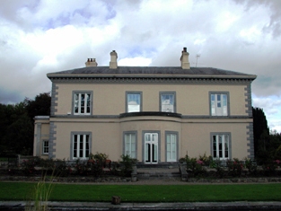
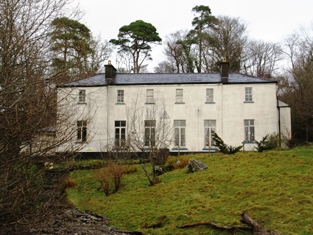
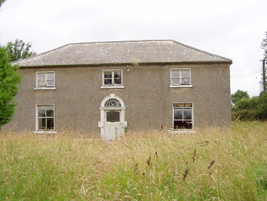
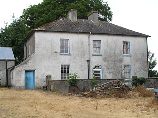
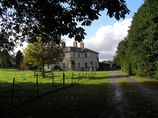
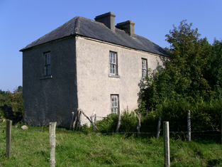
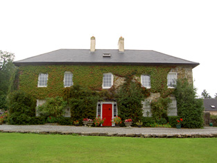
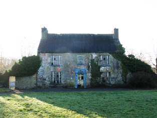
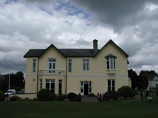
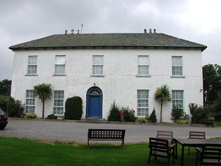
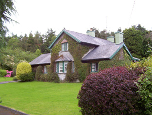
| Tully Lodge [Murrisk] | The original house was built in the early 19th century by the Garveys. At the time of Griffith's Valuation, it was held in fee by James Garvey and valued at £10. It was sold to the O'Dowds in the mid-1880s and to the Harman family in 1947. A house is still extant at the site. |
![Photo of Tully Lodge [Murrisk]](https://landedestates.ie/storage/img/orig/2958.jpg)
|
| Tully More House | Edward Perry was leasing a house valued at £5 as well as over 100 acres at Tully More, barony of Tirerrill, from the Cooper estate at the time of Griffith's Valuation. Tullymore House is still extant but unoccupied |
|
| Tullyallen House | Situated very close to Tullyallen Lough on the Brownlow estate, the buildings at Tullyallen House were valued at £17 in the mid-19th century. The occupant was Anne Kelly. James Murphy, farmer and Justice of the Peace, was resident in the early 20th century. | |
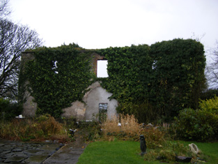
| Tullybrook | Charles Johnston was leasing this property from the estate of the Provost and Fellows of Trinity College at the time of Griffith’s Valuation. The buildings were valued at £20 at the time. This house appears to have been built after the 1st edition Ordnance Survey map of the 1830s. It is labelled Tullybrook on the later editions. It is now a ruin. | |
| Tullyland | This property was held in fee by the representatives of Messers. Cornwall at the time of Griffith's Valuation, when it was valued at £8. A house still exists at the site. |
|
| Tullyland House | William Westropp and others were leasing this property to Nicholas Thomas at the time of Griffith's Valuation, when it was valued at £7 10s. There is still a house named as Tullyland House, at this site. | |
| Tullylease | Hajba writes that the Morgans [Morgells] had an interest in this house through marriage with the Sullivans. Occupied by John Sullivan in 1814 and partly rebuilt by William Sullivan in the 1830s. Occupied by William Sullivan in the early 1850s and held from the representatives of Crosbie Morgel, when it was valued at £15.15 shillings. Acquired by James Lynch at the end of the 19th century and restored by the present owners. |
|
| Tullynally Castle | The National Built Heritage Service suggests the bulk of Tullynally Castle was built c.1730 but may incorporate the fabric of a house built for Henry Pakenham in the mid-C17. It had a number of phases of construction throughout its long history. Formerly known as Pakenham Hall, it has been the seat of the Pakenham family for over 350 years. At the time of Griffiths Valuation in the mid-1850s it was valued at £200 and had the same valuation in 1906. It is still extant and occupied by the Pakenham family. |
|
| Tullyowen | Eliza Jane Campbell was leasing this property from the Abercorn estate at the time of Griffiths Valuation in the 1850s, when it was valued at £12. In 1786 Wilson noted it as a seat of a Mr Thomson. It does not appear to be extant now. | |
| Tullyrap | Alexander Finlay was leasing this property from the Abercorn estate at the time of Griffiths Valuation in the 1850s, when it was valued at £25 and had an adjacent mill. A substantial farm still occupies the site. | |
| Tullystown | At the time of Griffiths Valuation in the early 1850s James McCullagh was leasing this property from the Duke of Buckingham’s estate when it was valued at £11. It was still in the McCullough family in 1906 with the same valuation. O'Brien records that Tullystown was damaged by fire in 2013 and gives an account of the various buildings that have existed at this site. |
|
| Tullyvin House | Tullyvin was originally a home of the Moore family. In 1814 the Reverend Benjamin Adams was resident. It was inherited by Maxwell Boyle, who according to the National Inventory of Architectural Heritage rebuilt the house circa 1820. At the time of Griffith’s Valuation the house was vacant but in the possession of Maxwell W. Boyle. It was valued at £30 for rates. In 1876, Tullyvin was the home of Mrs Charlotte Townley, the owner of over 2,000 acres in the county. The house had a rateable valuation of £30.10.0. in 1906 and Maxwell J. Boyle was recorded as the occupier. This house is still a fine residence. |
|
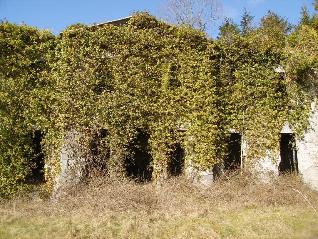
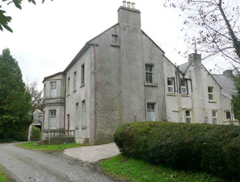
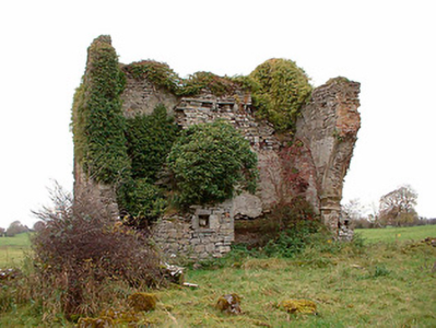
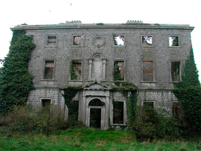
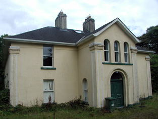
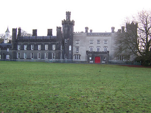
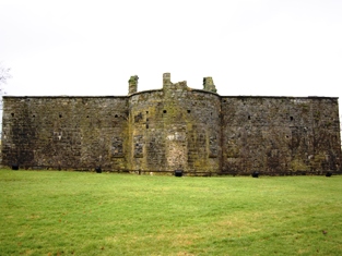
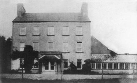
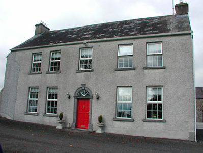
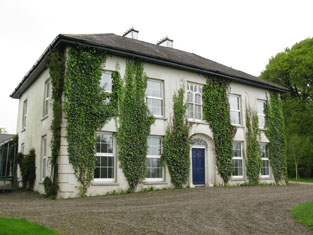
| Turbotstown [Turbotstown House] | The National Inventory of Architectural Heritage suggests that the present house at Turbotstown was built in the early decades of the nineteenth century, on the site of an earlier house. At the time of Griffiths Valuation in the early 1850s it was held in fee by Gerald Dease when the buildings were valued at £80. In 1906 it was still the property of Major Gerald Dease and valued at £84. It was occupied by the Dease family until the 20th century and is still extant. O'Brien provides a detailed account of this house and its occupants. On the 1st edition Ordnance Survey map it is labelled Turbotstown House but on the 25-inch edition of the early 20th century it is labelled Turbotston. |
![Photo of Turbotstown [Turbotstown House]](https://landedestates.ie/storage/img/orig/3616.png)
|
| Ture Lodge | Ture Lodge, facing east onto Clonamullig Lough, was the home of John Mont. Jones in 1814. Cavan newspapers refer to David Griffith as the occupier in 1847 and Joseph Knight in 1850. The house was vacant when surveyed for Griffith’s Valuation. Myles Reilly was the immediate lessor holding from James H. Story. The buildings were valued at £18. In 1876 Mrs Sarah Story owned 814 acres in county Cavan, while James Story of the same address owned 405 acres. This house was marked ‘in ruins’ on the 25 inch map of the early 20th century. | |
| Turin | Turin Castle has recently been renovated. The house no longer exists but some of the farm buildings are still visible. In the 1770s Kirwan esq occupied Turin Castle and in 1814 Arthur Browne was recorded as resident there. At the time of the first Ordnance Survey Samuel Lindsey Bucknall was living in Turin House and it was occupied by the Rutherfords in the 1850s. |
|
| Turlough House | Built early in the 18th century this was the main residence of the family for much of the 18th century. In 1786 Wilson refers to Turlough as the seat of Charles Lionel Fitzgerald. It was referred to as Turlough Park though it is not named on the 1st edition Ordnance Survey map and was unoccupied at the time of Griffith's Valuation. It is now a ruin. |
|
| Turlough House (Ballymoe) | Held in fee by John Cheevers at the time of Griffith's Valuation when the buildings were valued at £7 10s. Occupied by John J. Cheevers in the early 20th century. This house is no longer extant | |
| Turlough Lodge/Cottage | Home of the Semple family in the 19th century. At the time of Griffith's Valuation William Semple occupied a house valued at £10, leased from the Fitzgerald estate. It is labelled Turlough Lodge on the 25-inch Ordnance Survey map of the 1890s though it also appears to have been known as Turlough Cottage. It is still extant but derelict. |
|
| Turlough Park | Built in 1865 to the design of Sir Thomas Newenham Deane, this Victorian Gothic house was sold to Mayo County Council in 1991 and is now part of the Museum of Country Life. |
|
| Turoe | Wilson refers to "Tourow" as the seat of Mr. Dolpin in 1786. Oliver Dolphin owned Turoe at the time of Griffith's Valuation when it was valued at £20. Slater refers to it as the seat of Miss Dolphin in 1894. In 1906 the mansion at Turoe was the property of Hubert Dolphin and was valued at £16. The original house is no longer extant but evidence of the stable yard and walled garden can be seen at the site, close to Turoe Pet Farm. |
|
| Turret Farm House | At the time of Griffith's Valuation occupied by St John Jeffreys and held by him in fee, the buildings were valued at £26. | |
| Turrock | This house was in ruins by the time of the first Ordnance Survey in the mid 1830s. The Kellys lived at Weston, county Meath, from the mid 19th century to the 1930s. | |
| Turtulla | A member of the Blunden family was living at "Turkla" close to Thurles in the 1770s. William Nicholson was living at Turtola in 1814. Lewis writes in 1837 that it was the property of Valentine Maher but that John B. O'Brien was resident. A flour mill was located on the property. In 1840 the Ordnance Survey Name Books record a Mr. Lister in charge of the mill. They refer to Valentine Maher as the proprietor. By the time of Griffith's Valuation Nicholas Maher was the occupier. He held the property from the Court of Chancery and the buildings were valued at £50+. Nicholas had succeeded his cousin Valentine in 1844 and died without heirs in 1871. Turtulla then became the home of the Barry family from county Limerick. It was unoccupied from 1927 to 1944 when it was purchased by the Thurles golf club and has been their club house since then. see http://www.thurlesgolfclub.com/cluboverview.html |
|
| Twyford | Twyford House was originally built about 1760 by the Handcock Family of Waterstown House, Glassan, but passed into the ownership of the Hodson Family, at the end of the 18th century. In 1814 John Hodson was resident and E Hodson in 1837. Valued at £24 John Hodson was the occupant at the time of Griffith’s Valuation (publ. 1854), holding the property from John Longsworth. The Hodsons continued to reside at Twyford until it was sold about 1960. The house is now derelict. |
|
| Tynte Lodge | Joseph Tynte was leasing lands from the White estate and later purchased 30 acres of land from Lord Massy (who had inherited that estate) for the building of Tynte Lodge. The Inventory of Architectual Heritage, however, contends that Tynte Lodge was built in the eighteenth century so perhaps Tynte was reconstructing an earlier building. At the time of Griffith's Valuation the property at Tullaghan was valued at £18 and was leased by Tynte to Hugh Montgomery. In 1906 Mervyn Tynte was the owner of the mansion house at Tullaghan valued at £51. |
|
| Tyone | In the 1770s Donagh O'Brien of Tyone had bolting mills near Nenagh and an estate worth £8,000 in England and Ireland (Kilboy Papers). Donough O'Brien was resident at Tyone, Nenagh, in 1814. Malachy Ryan held a house, flour mill and land from Stafford O'Brien at Tyone in the mid 19th century. The buildings were valued at £75. Thomas John Ryan son of Malachy was living at Tyone in the 1870s. This house is still a residence. |
|
| Tyrcallan/The Nursery (Raphoe) | At the time of Griffiths Valuation in the 1850s, Reverend William Stewart was leasing this property from the Conyngham estate when it was valued at £18. It is labelled as The Nursery on the 1st edition Ordnance Survey map but as Tyrcallan on the later 25-inch edition. In 1837 Lewis referred to it as Tyrcallan, the seat of H. Steevens and as having an observatory on the grounds. In 1906 it was recorded as part of the estate of the Marquis of Conyngham with a valuation of over £10. The National Inventory of Architectural Heritage suggests it was originally built as a hunting lodge. It is now derelict. |
|
| Tyredagh Castle | Built by at least 1814 when it was occupied by Thomas Brown who in that year married Elizabeth Comyn. In 1837 Mrs Browne was in residence. By the time of Griffith's Valuation Mary Gore was the occupant holding the property from Eliza Browne. Weir writes that the house was accidentally burnt down about 1903. | |
| Tyrone | Tyrone was built in the early 19th century. It is described in the OS Name Books as "a beautiful residence" in the 1830s. At the time of Griffith's Valuation, it was in the possession of Christopher St.George and was valued at £50. In 1894 Slater notes it as the seat of Robert J.K. St.George. The family ceased to live there in the early twentieth century. Its ruins can be seen overlooking the estuary of the Clarin river. |
|
| Tyrrellstown | Tyrrellstown House, named on the first edition OS map, was a five-bay two-storey house, built c.1790, against the side of a Tyrrell tower house, probably by the Bomford family. Tyrrellstown House was the home of Benjamin Briggs in 1814 and of a Mr Briggs in 1837. At the time of Griffith’s Valuation (publ. 1854) John McCulloch held the house valued at £12 from David North, a nephew of Isaac Bomford. Purchased by the Ronan family in the 20th century. It is now demolished. |
|
| Umma or Emoe House | Umma or Emoe House is named on the first edition OS map. It was a Magan home from at least the early 18th century. Thomas Magan was resident in 1814. O’Brien writes that Francis Magan was the last family member to reside at Emoe. It was recorded as his seat in 1837. He died in 1841. At the time of Griffith’s Valuation (publ. 1854) James Hill Shaw held the house valued at £15 from George A Boyd. Another building with the same name is marked on the 25 inch map to the south east of the original house and is still extant (N198 453). This second house was built in 1900 (O’Brien) by the Shaw family. James Shaw of Ballymahon purchased the lands in 1875. Occupied by the Skelly family in the 20th century. | |
| Ummera | Robert Travers was leasing this property to Samuel McCaul at the time of Griffith's Valuation, when it was valued at £14. Lewis refers to it as the seat of Rev. B. Swete in 1837. In 1814 Leet notes Ummery as the seat of Rev. A. Sealy. Ummera House is still extant. |

|
| Underhill Cottage | Held from Benjamin H. Holmes by William Hayle in 1851 when it was valued at £13. Now demolished. | |
| Union | In 1906 Col. E.H Cooper's estate owned a property at Union, barony of Tirerrill, valued at £7. This may the gamekeeper's cottage which is still extant at this location. |
|
| Union Lodge | This house was the residence of the Reverend William Gifford in 1837. At the time of Griffith's Valuation Hughes Martin was the occupier. He held the property from William Coppinger and the buildings were valued at £21. | |
| Unionhall House | Colonel W.S. French was leasing a property valued at £28 to John Limerick, at the time of Griffith's Valuation. It was the residence of Col. W.Limerick in 1814. According to Townsend, Colonel Limerick had erected this "large and commodious dwelling" on his return from many years service with the East India Company. Union Hall is still extant and occupied. |

|
| Upland | William Spiller was leasing this property from Benjamin Gillman at the time of Griffith's Valuation when it was valued at £5 5s. There is still an extant house at this site. | |
| Upper Forest | A house valued at £20.10 shillings at the time of Griffith's Valuation, held by John Hassett from Thomas Gollock. It is still extant and occupied. |
|
| Upper Forest | Occupied by John Hassett at the time of Griffith's Valuation and held from Thomas Gollock. The house was valued at £20+. The representatives of John Hassett still lived at Forest in the 1870s. |