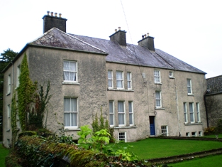
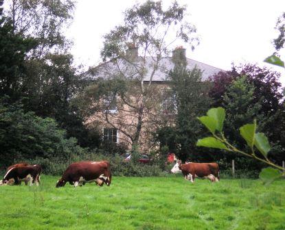
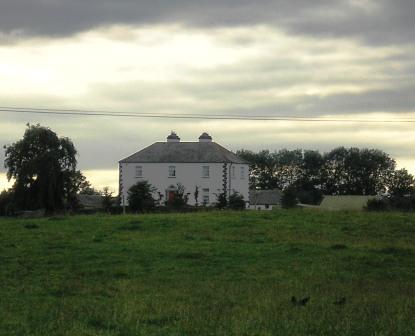
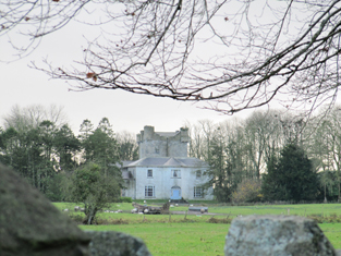
Annaghcallow
Houses within 15km of this house
Displaying 128 houses.
Houses within 15km of Annaghcallow
Displaying 128 houses.
| House name | Description | |
|---|---|---|
| Portumna | Reverend Lewis Hawkes was leasing a property at Portumna, valued at £16 from the Ecclesiasical Commissioners at the time of Griffith's Valuation. The Reverend Louis Hawkes of Brierfield died in 1857. A house still exists at the site. | |
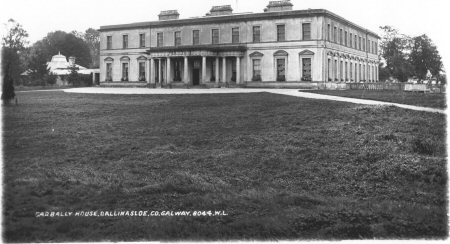
| Garbally Park | In 1783 Taylor and Skinner show Garbally as a seat of the Trench family. Wilson mentions Garbally , "the very fine seat of Willaim Power Keating Trench", in 1786. At the time of Griffith's Valuation it was the seat of the Earl of Clancarty and was valued at £150. It became St. Joseph's College, Garbally Park, in 1922 and has functioned as a school until very recently. It is still extant. |
|
| Grange | The Earl of Huntington's estate in Galway included a house valued at £7 at Grange, parish of Killeenadeema, leased to Patrick Murphy. A house labelled Grange House appears on the 1st edition Ordnance Survey map. On the 25-inch edition of the1890s the original house is not shown and Grange House is located at M878146. This house is now a ruin. | |
| Somerset House | At the time of Griffith's Valuation, Thomas Stratford Eyre was leasing a house valued at £20 to William Seymour. Slater refers to the house as the residence of Thomas Craddock in 1894. In 1906 the property at Somerset was held by Charles Seymour. The original house is not extant but there are extensive remains of estate architecture. |
|
| Brooklawn | Labelled Brooklawn House on both the First and 25-inch editions of the Ordnance Survey map though the buildings are slightly apart. In 1837 this house was the residence of a branch of the Blake family. At the time of Griffith's Valuation the house was leased to Michael McDermott by Thomas J. Blakely [sic]. It is no longer extant. | |
| Ballydonnellan Castle | At the time of Griffith's Valuation, Ballydonnellan Castle was occupied by John D. Mahon and was valued at £62. It was still extant in the 1890s but is described as "in ruins" on the 1933 edition of 6" map. These ruins are still visible. |
|
| Eastwell | In 1837 Lewis records Eastwell as the seat of C. Usher. At the time of Griffith's Valuation it was occupied by Christopher Usher and the buildings were valued at £79. By 1906 it was in the ownership of William A. Usher and was valued at £81. This house is no longer extant but extensive remains of stables, demesne and walled garden survive. |
|
| Pallas | Pallas was the largest of the Nugent properties in the parish of Tynagh, which also included Spring Garden, Flower Hill and Crannagh, a property that had been used in the eighteenth century. A mansion was built at Pallas for Anthony Nugent, 4th Lord Riverston, in 1797. Slater, in 1846, refers to the Hon. Anthony Nugent residing at "The Palace". At the time of Griffith's Valuation it was the property of Anthony Nugent and was valued at £46. In 1906 it was owned by the Earl of Westmeath and was valued at £52. It was demolished after World War II. A well-preserved tower house and the remains of a large 17th century residence can also be seen at Pallas. |

|
| Ballyeighter | In 1814 Ballyeighter was the residence of Anthony Donnellan. Lewis records Balleighter as the seat of P. Donnellan. By 1855 it was being leased by Lord Clonbrock's estate to Martin Coolahan and was valued at £8. The Coolahans continued to own the property until the mid-20th century when it was divided by the Land Commission who also demolished the house. There is no trace of Ballyeighter now. | |
| Hearnesbrook | The property at Hearnesbrook was occupied by George Hearn Kirkaldy at the time of Griffith's Valuation. It was also recorded as his residence by Lewis in 1837. In 1814 Hearnsbrook was the residence of Major Lyons. Slater notes it as the seat of A.J. Mackay in 1894. In 1783 Taylor and Skinner, and Wilson, in 1786, recorded it as a seat of the Hearn family. In 1885 Walford refers to William Clifford Bermingham-Ruthven as "of Hearnesbrooke". It is still extant and occupied and is the focus of a large farming enterprise. |
|
| Spring Garden | Spring Garden was a Nugent house in the parish of Tynagh, valued at £10 at the time of Griffith's Valuation. It had earlier belonged to the Persses but had been sold by them in the early 1850s. In 1906 this was the property of Hon. Richard A. Nugent. It is described as "in ruins" on the 25-inch Ordnance Survey map of the 1890s. | |
| Derrywillan House | A gate lodge and caretaker's house belonging to this estate were located in the townland of Redpark while the main house was in the townland of Tynagh. In 1837 Lewis records Derrywilliam House as the seat of H. Kilkelly. Taylor and Skinner record Dirry as the seat of the French family in 1783. | |
| Flower Hill | Flower Hill was occupied by Anthony F. Nugent at the time of Griffith's Valuation when it was valued at £28. IN 1894 it was the residence of Charles Nugent. Flower Hill is still extant and now operates as an equestrian centre. See www.flowerhill.net |
|
| Springvale | The OS Name Books mention the existence of Springvale House in the townland of Lisheenagat together with some plantation and ornamental ground. At the time of Griffith's Valuation, Francis Lynch was occupying a property at Lisheennagat, barony of Leitrim, valued at £9. In 1906 this property was owned by Michael Lynch. The original house is not extant though some estate buildings remain. | |
| Tully | Joseph Cowan leased lands and a house valued at £7 at Tully to Matthew Madden in 1856. In 1906 Tully was the property of Stephen Cowan and still valued at £7. It is still extant and occupied. |
|
| Cappaluane Glebe | Rev. Richard Eyre was leasing the Glebe house at Cappaluane, barony of Longford, from the Ecclesiastical Commissioners at the time of Griffith's Valuation when it was valued at £18. He was also leasing land from John Eyre. Cappaluane Glebe is still extant and occupied. In 2006 it was offered for sale. |
|
| Eyrecourt Castle | Eyrecourt Castle was originally built in the 1660s. In 1786 Wilson refers to it as "the fine seat of Lord Eyre, with ample demesnes". It is mentioned as a gentleman's seat in the Ordnance Survey Name Books in the 1830s. It was held in fee by John Eyre at the time of Griffith's Valuation when it was valued at £48. A fine lithograph of the Castle appears in the Encumbered Estates schedule when the estate was offered for sale in June 1854. The castle itself is now in ruins. The fine oak staircase is now in the Detroit Institute of Arts. Substantial evidence of the demesne still remains. |
|
| Fearmore House | In 1856 Edward Horsman was leasing a house in the townland of Fearmore from the Clanricarde estate. It was valued at almost £9 at the time. It is still extant and occupied. |
|
| Redmounthill Farm | At the time of Griffith's Valuation the property at Ballynamudagh, a steward's house and out buildings valued at £14, were part of the Pollok estate. In 1906 this property was valued at £41. On the 25-inch Ordnance Survey map of the 1890s the buildings are labelled Redmounthill Farm. The house and some portions of the farm buildings remain at the site. |

|
| Woodview | In the 1830s a "gentleman's residence" named Woodview already existed here. Slater notes it as the seat of Richard G. Daly in 1846. At the time of Griffith's Valuation Richard Eyre was leasing this property from Richard G. Daly. By 1906 this house had become part of the Pollok estate and was valued at £10. The house is still extant and occupied. |

|
| Woburn | A "gentleman's seat" called Waburn is recorded here in the Ordnance Survey Name Books of the 1830s. Slater refers to Woburn as the seat of Henry Flanagan in 1846. Buildings in this townland valued at £15 were leased by Henry Flanagan from the Clanricarde estate in 1856. Woburn is still extant though disused. |
|
| Moorfield House | In 1778and 1786, this house was the residence of the Blake family. Moorfield was a steward's house on the Eyre estate at the time of Griffith's Valuation. In April 1869 the Eyre's Moorfield estate, including the house, was offered for sale in the Landed Estates court. In 1906 it was owned by James Howard Jnr and was valued at £28. The National Inventory of Architectural Heritage suggests that the extant house at Moorfield is of late nineteenth century date. |
|
| Heathlawn | At the time of Griffith's Valuation, Heathlawn house, valued at £31, was occupied by George Saunderson. In 1837, Lewis records it as the seat of M. Monahan. Slater, in 1846, also notes it as the seat of Michael Monaghan. In 1906 it was the property of James H. Monahan. In 1783 Taylor and Skinner, and Wilson, writing in 1786, noted Heathlawn as a seat of the Hamilton family. It is no longer extant. | |
| Rathmore | The property at Rathmore was the residence of Major McCann in 1814. At the time of Griffith's Valuation it was occupied by James McDermott, a family with which it was associated for many years. It had also been recorded as his seat by Lewis in 1837. Earlier, in 1783, Taylor and Skinner recorded it as a seat of the Browne family as did Wilson in 1786. In 1906 it was owned by James McDermott. The house at Rathmore, though smaller than originally, is still extant and occupied. The gatelodge is also extant having undergone extensive renovation. |
|
| Moat | A property in the townland of Moat, parish of Killimorbologue, valued at £9 was being leased from the Clanricarde estate by John Donnelly in 1856. The house was demolished in the later half of the twentieth century and no traces remain. | |
| Earlstown | In 1786 Wilson refers to "Capasell" s the seat of Mr. Devenish [?]. The house at this location is labelled Earlstown on the 1st edition Ordnance Survey map. In 1846 Slater refers to Robert Grace resident at Earlston. Robert Eyre was leasing a property in the townland of Cappasallagh, parish of Kilmalinogue, barony of Longford, valued at £11 from the Clanricarde estate in 1856. There are still occupied buildings at this site, the focus of a large farming enterprise. |
|
| Corr Lodge/Corr House | At the time of Griffith's Valuation the property at Corr was being leased by R.P.Dolphin to Edmund Mahon. In the 1780s, both Taylor and Skinner and Wilson recorded Corr as a seat of the Dolphin family. Slater refers to it as the seat of Redmond D. in 1846. By the 1890s it had become known as Corr House. In 1906, the mansion house at Corr, valued at £15, was owned by Marcella Blake Forster. It is no longer extant. |
|
| Derryhivney House/Harding Grove | Wilson may be referring to this property when he mentions the ruins of a castle at "Derryborn" and the seat of Mr. Hind. In 1814 this house was known as Harding Grove and was the seat of Jonathan Harding. It appears under this title on the 1st edition Ordnance Survey map. The Harding family also had an estate in north Tipperary. In 1846 Slater refers to "Derryhiney" as the seat of Cuthbert Fetherston. At the time of Griffith's Valuation, the house at Derryhivney was occupied by him. On the 25-inch map of the 1890s it is labelled Derryhivney House. David England Young of Ballygibbon, county Tipperary and Harding Grove, county Galway is recorded in Walfords (1910). |
|
| Prospect (Meelick) | In 1856 Joseph Cowan was leasing a property at Prospect, in the parish of Meelick, barony of Longford, from Francis Usher. In 1837 Lewis recorded Prospect as the seat of C.A. O'Malley. Slater refers to it as the seat of John Smith in 1846. In 1906 Prospect was the property of Ernest Kenny and valued at £12. In 1778 and 1786, this property was the residence of the French family. Prospect House is still extant and occupied. |
|
| Kilquain | At the time of Griffith's Valuation Allen Pollok held a property in Kilquain valued at £5 10s which was used as a steward's house. There is evidence of estate architecture in the vicinity but twentieth century buildings on site. | |
| Gurtray/Gortrea/Gortray/Fairfield | Writing in 1786 Wilson refers to this house as Fairfield, the seat of Mr. Hamilton. Ambrose O'Kelly was the owner of a house valued at £20 in Gortrea or Fairfield, parish of Kilmalinoge, barony of Longford, county Galway in 1856. Slater refers to "Gurtray" as the seat of John Appleyard O'Kelly in 1894. In 1906 this house was the property of John A. O'Kelly. According to family tradition the house lost its roof on the Night of the Big Wind in 1839. It is still extant and occupied and in 2007 was offered for sale. |
|
| Raheen | At the time of Griffith's Valuation, Clifford Trotter was leasing a property valued at £7 along with 284 acres to James Lynam. This property is still extant and occupied. |
|
| Fairy Hill | Thomas Doolan was leasing a property at Fairy Hill, valued at £20, to Charles Cooper at the time of Griffith's Valuation. Slater had noted it as the residence of Thomas Doolan in 1846. In 1894 Slater records Fairy Hill as the seat of Colonel Cheevers. This house is still extant. |
|
| Palmerstown ( Pokoroko) | In 1814 a house at Fairy Hill was the residence of Mr. Palmer. This property was held on a lease renewable forever from the Clanricarde estate. It is recorded in Lewis under Portumna town. In 1865 it was occupied by Lewis Goodbody who had purchased it in the Landed Estates Court in 1861. The sale notice refers to the house as "Pokoroko" and this title appears again in the Cunningham sale report of June 1886. However on both the 1st and 25-inch editions of the Ordnance Survey map it is labelled Palmerstown House, the name by which it is still known. It is still extant and occupied. |
|
| Thornfield | Slater refers to Thornfield as the seat of John Davis in 1846. In 1856 Thomas Galbraith was leasing a property valued at £7 in the townland of Thornfield, parish of Lickmolassy, barony of Longford, from the Clanricarde estate. It is no longer extant. | |
| Gortaha House | Cuthbert Featherston held a property valued at £10 in the townland of Gortaha, parish of Lickmolassy, barony of Longford, in 1856. It is labelled Gortaha House on the 1st edition Ordnance Survey Map. The 25-inch map of the 1890s records that it was "in ruins" and very little now remains. | |
| Willmount or Gortnacloghy | In 1856 Matthew McDonagh was leasing a property valued at £19 in the townland of Gortnacloghy, parish of Lickmolassy, barony of Longford, from the Clanricarde estate. This house was also known as Wilmount or Wellmount. |
|
| Oakley Park | At the time of Griffith's Valuation, John Cunningham was leasing a house valued at £13 at Gowil, parish of Lickmolassy, from Anne Shewbridge. This appears to be the house known as Oakley Park, occupied in the 1870s by the Pigot family. It is still extant and occupied. |
|
| Ormond View | The representatives of Redmond Dolphin were leasing a property at Ballycrossaun, barony of Longford, to John D. Lemon at the time of Griffith's Valuation when it was valued at £12. Slater notes this property as the seat of Joseph Lemon in 1846. Hogan states that this house was formerly known as Waterview. Ormond View is still extant and occupied. |
|
| Lisduff | Thomas Ellis was occupying the house at Lisduff at the time of Griffith's Valuation when it was valued at £18. Earlier, in 1837, Lewis records Lisduff as the seat of a Mr. Lyons. Taylor and Skinner recorded Lisduff as a seat of the Kelly [Browne Kelly of Westport] family in 1783. Documents in the National Library of Ireland indicate it was in the ownershop of Henry Brush in 1862. Slater refers to is as the seat of John Abbott in 1894. In 1906 this property was occupied by H.D.M. Barton who also held over 250 acres of untenanted land in the area. The house is still extant. |
|
| Longford Lodge | In 1846 Slater refers to Patrick and Stephen Kelly, both of "Longford House". Patrick Kelly was occupying the house at Gortadullisk, barony of Longford at the time of Griffith's Valuation. In 1837 Lewis had recorded Longford Lodge as the home of a Major Kelly. In 1906 it was owned by Denis Kelly and was valued at almost £15. It is no longer extant though part of the walled garden remains. |
|
| Greenfield/ Fahy | In 1777 a house at Fahy is recorded by Taylor and Skinner as a Hamilton residence. In 1786 Wilson mentions Faghy as the seat of Mr. Hamilton. Lewis records Fahy as the seat of T. Burke in 1837. The OS Name Books state that the gentleman's residence in the townland of Fahy was called Greenfield. At the time of Griffith's Valuation, Pierce Joyce held over 400 acres of this townland together with buildings valued at over £6. The house is labelled Greenfield on both the 1st and 25-inch Ordnance Survey maps. Some ruins survive at the site. | |
| Lismore Castle | In 1778 Lismore Castle was the residence of the Daly family. Wilson refers it as the seat of Anthony Daly in 1786. It is described as "in ruins" on 25-inch Ordnance Survey map of the 1890s. Some elements of the demesne are still visible. |
|
| Burkeville | Burkeville was offered for sale in the Encumbered estates court in July 1852. At the time, Maurice Bennett was the tenant of this "fine commodious dwelling house". At the time of Griffith's Valuation it was held by Nicholas Coolaghan and valued at almost £10. It was still in the possession of Nicholas Coolaghan in 1906. A house still exists at the site. | |
| Quainsborough/Quansbury Lodge/Stowlin | Originally a Daly house. In 1783 Taylor and Skinner and Wilson, in 1786, record Queensborough as a seat of the Earl of Louth. Slater refers to Quansborough Lodges as the seat of William B. Burke in 1846. Mentioned in the sale notice for portion of the St. George estate in November 1853. John P Watson was the occupier of a house valued at £13 in the townland of Stowlin, parish of Kilquain, barony of Longford, in 1856. In 1906 this house was owned by Kate Watson and was valued at £33. Buildings are still extant at site though may have been modernised. The Clonbrock Estate Papers, Collection List 54 in the National Library contain early 19th century rentals of the Quansbury estate. In many documents the name of this house is spelt Quansbury but on the Ordnance Survey maps it is spelt Quainsborough. |
|
| Ballydonagh | Lewis records Ballydonagh as the seat of F. Madden in 1837. At the time of Griffith's Valuation the house was occupied by Francis Madden leasing from the Haughton estate and was valued at almost £4. Substantial ruins still remain at this site. | |
| Ballymore Castle | At the time of Griffith's Valuation Ballymore Castle was occupied by Thomas Seymour. This house continued to be the seat of the Seymour family until at least 1906 and was noted by Slater as the seat of Walter G. Seymour in 1894. It is still extant and occupied. |
|
| Bellevue/Lisreaghan | Belview was the main seat of the Laurence family in east Galway. Wilson, writing in 1786, refers to "Belle-view" as the seat of Mr. Lawrence "with beautiful plantations". In the 1850s it was valued at £42 and was occupied by Walter Laurence jun. In 1906 it was the property of Rev. Charles Lawrence. It is no longer extant but a famous gateway, erected in support of the Volunteers of 1782, is still visible. |
|
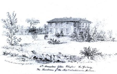
| St. Brendan's | Archdeacon Butson is listed as the occupier of the house in Glebe townland in 1855 when it was valued at £25. It is labelled St. Brendan's on both the 1st and 25-inch edition Ordnance Survey Maps. This house is no longer extant. |
|
| Abbeyland Cottage | A herd's house in the townland of Abbeyland Great, parish of Clonfert, barony of Longford, was part of Archdeacon Butson's estate. It was valued at £1 10 at the time of Griffith's Valuation and leased to John Kenny. This house is no longer extant. | |
| Abbeyland House | Archdeacon Butson was leasing a steward's house, valued at £8, in the townland of Abbeyland Great, parish of Clonfert, barony of Longford, to Allan Pollok, at the time of Griffith's Valuation. Buildings still exist at the site. | |
| Cloonconra | A house in the townland of Cloonconra, parish of Clonfert, barony of Longford, was valued at £10. It was part of Archdeacon Butson's estate at the time of Griffith's Valuation. It is labelled Cloonconra Farm on the 25-inch Ordnance Survey map of the 1890s. A farm still exists at the site. | |
| Clonfert Palace | Clonfert Palace was built in the late 17th century and altered in the 18th century. It was the residence of the Church of Ireland bishop of Clonfert until 1836 when that diocese was amalgamated with Killaloe. At the time of Griffith's Valuation, John E. Trench was leasing the property valued at £20 from the Ecclesiastical Commissioners in the townland of Clonfert Demesne, barony of Longford, county Galway. In 1906 it was in the ownership of Charles O'Hara Trench. Later occupied by the British fascist leader, Oswald Mosley. It was damaged by fire in 1954 and has been derelict since. |
|
| Clonfert Cottage | In 1855, a house valued at £8 and belonging to the representatives of Robert Seymour, was leased by James Buchanan. Slater refers to "Clonfert Cottage" as the residence of Robert Seymour in 1846. On the 25-inch maps of 1890s the property at this site is labelled "Constabulary Barracks". | |
| Cloonkea | John Eyre was leasing a house valued at £10 from the estate of Dr. Duggan in 1855. The house was located at Cloonkea, barony of Longford. It was advertised for sale in 2007. |
|
| Lismore | Henry Kenny was leasing a property valued at £8 from Lord Dunsandle in 1855. It was located at Lismore Demesne, parish of Clonfert. Lismore Castle is shown there on the 1st edition Ordnance Survey map. By the 1890s this building is in ruins but Lismore Farm (M943160) is located nearby. Ruins of both buildings are still visible at the site. MacLysaght, in his 1944 report on the Dunsandle papers, notes the existence of deeds relating to Fergus Madden of Lismore. | |
| Hemmings Ville | The representatives of Robert Seymour were leasing a house valued at £6 and almost to 250 acres to Sidney Smith in 1855. This property is labelled "Hemming's Ville" on both the First and 25-inch editions of the Ordnance Survey maps. There is still an extant house at the site. | |
| Kilnaborris Dower House | John Seymour was leasing a property valued at £8 from Hubert Moore at the time of Griffith's Valuation. It was located in the townland of Kilnaborris, parish of Clonfert. Kilnaborris Dower House is still extant and now offered as holiday accommodation. |
|
| Shannon View | Belinda C. Madden is listed as the lessor of two properties in the townland of Kilnaborris, parish of Clonfert, in 1855. The property which appears to have been known as Shannon View was vacant at this time. It was valued at £12. In July 1889 property at Kilnaborris, or Shannon View was offered for sale in the Land Judges' Court by William C. Bermingham Ruthven. The sale was adjourned. In 1783 Taylor and Skinner had recorded it as a residence of the Madden family. In 1786 Wilson refers to Kilnaborris as the seat of Mr. Madden. The National Inventory of Architectural Heritage suggests the house now extant on the site was built c.1870. It suffered fire damage in the twentieth century but was rebuilt c.2002. The house is now known as Lairakeen. |
|
| Shannon Grove | Shannon Grove was valued at £20 and was leased to Hubert Moore in 1855. William R. Seton was the owner of a house valued at £65 in the townland of Kilnaborris in 1906. Leet's Directory records Shannon Grove as the residence of Hon. B. Yelverton in 1814. A substantial house still exists at Shannon Grove. |
|
| Killeragh | At the time of Griffith's Valuation, Thomas Kenny was occupying a property valued at £5 together with 180 acres, in the townland of Killeragh, parish of Clonfert, barony of Longford. A house is still extant at the site. | |
| Oghil | At the time of Griffith's Valuation, Allan Pollok held a property at Oghil More townland, parish of Clonfert, on which a house was in progress, together with a mill and other buildings. The property stood on 368 acres. The mill chimney was demolished during the later twentieth century but many of the other buildings remain. | |
| Sycamorehill | At the time of Griffith's Valuation, Allan Pollok held a property at Sycamorehill, parish of Clonfert, valued at £16. Molloy states that this house was burned during land agitation on the Pollok estate in the 1850s but it was subsequently re-built. Sycamorehill is still extant and part of a large farm. |

|
| Coolcarta Farm | At the time of Griffith's Valuation Allan Pollok held a property valued at £20 in the townland of Annaghcorrib, parish of Clonfert, barony of Longford. It is labelled as Coolcarta Farm on the 25-inch Ordnance Survey map of the 1890s. Padraig Lane states that this property was damaged by fire during land agitation in the 1850s. A substantial farm still exists at the site. | |
| Kylemore Dairy | Allan Pollok held a property valued at £7 together with over 400 acres in the townland of Kylemore, parish of Clonfert, barony of Longford in 1856. On the 25-inch Ordnance survey map of the 1890s there is a property labelled Kylemore Dairy in this townland. Parts of the farm buildings remain at the site. | |
| Coolbeg House | In 1856 Thomas Stratford Eyre was leasing a property valued at £5 together with 146 acres, located in the townland of Coolbeg, parish of Clontuskert, barony of Longford to William Seymour. It is labelled Coolbeg House on the 25-inch Ordnance Survey map of the 1890s. A house still exists at the site. | |
| Crowsnest | In 1856 Allan Pollok was the occupier and lessor of a property valued at £6 together with over 460 acres, in the townland of Crowsnest, parish of Clontuskert, barony of Longford. Molloy provides a detailed description of the huge farmyard (M868239) in the neighbouring townland of Ganaveen which was part of the Pollok estate. The latter was destroyed by fire in 1920. The Crowsnest property is now in ruins. |

|
| Lismany/Lismanny | Allan Pollok's estate was centred on the property at Lismany. In 1856 the buildings there were valued at £10. In 1906 Lismanny was owned by the representatives of John Pollok. It was valued at £90. It was sold by the Pollok family in 1924 and demolished some years later. Only the cellar of the house together with the ruins of an extensive range of estate buildings now remains at Lismanny. However both gatelodges and several other estate houses are still occupied. |
|
| Somerset Glebe | At the time of Griffith's Valuation William Seymour was leasing a property in the townland of Somerset, parish of Clontuskert, valued at £11 to Rev. Adolphus Drought. This property is now a ruin. | |
| Bettyville | At the time of Griffith's Valuation, a house at Cloonlahan, barony of Longford, valued at £5 together with over 300 acres was held by Michael McDermott. | |
| Huntly | Denis Delahunt was recorded as the occupier of a house, valued at £8, at Feagh, in the parish of Kiltormer, at the time of Griffith's Valuation. In 1906 the house at Feagh was owned by John A. O'Kelly and was valued at almost £6. A substantial modern farm exists at the site. | |
| Killwood House/Gortnaraheen Glebe | In 1856, Thomas Stratford Eyre was leasing a property, described as a glebe house, in the townland of Gortnaraheen, valued at £8, to Rev. Thomas Grome. It has become known as Killwood House by the 1890s. A house still exists at the site. | |
| Mount Prospect (Kiltormer) | In 1856 Rev. David Seymour was leasing a house valued at £12 in the townland of Kiltormer East, barony of Longford, from Thomas Stratford Eyre. In 1837 Lewis mentions a residence of the Seymour family known as "Mount Pleasant" in this area. On the 25-inch Ordnance Survey map of the 1890s, however, this house is labelled Mount Prospect. It is no longer extant. | |
| Eyreville | A late 18th and early 19th century house built for the Eyre family. Lewis records Eyreville as the seat of T.S. Eyre in 1837. In 1856 Thomas Stratford Eyre was occupying a property valued at £36 in Newtowneyre, parish of Kiltormer, barony of Longford. in 1906 it was in the possession of the representatives of Thomas D. Eyre. In 2006 permission was being sought to carry out works on the site of Eyreville. While the house is no longer extant the remains of demesne buildings exist. |
|
| Newpark | At the time of Griffith's Valuation, Peter Callanan occupied a house valued at £10 in the townland of Skecoor, parish of Kiltormer, barony of Longford. Lewis records this house as the seat of P. Callaghan in 1837. In 1894 and 1906 it was the home of Rosa Callanan. Now known as Skycur House it is still extant and well-maintained. |
|
| Fairfield House | Lewis records Fairfield as the residence of T. Wade in 1837. It is described in the Ordnance Survey Name books as "built on rising ground from which there is a good prospect". At the time of Griffith's Valuation the house was being leased by Thomas Wade from the Handy estate. In 1906 it was in the possession of Rochford Wade when it was valued at £23. Fairfield House is no longer extant and the demesne is the focus for a major sawmilling operation. |
|
| Oatfield | Oatfield House, owned by John Longworth , was vacant at the time of Griffith's Valuation. Earlier, in 1837, Lewis had recorded it as the seat of Major Lynch even though this house had been in the possession of the Longworth family since at least 1814. The Ordnance Survey Field name books also record it as the residence of Major Lynch. In 1783 Taylor & Skinner and in 1786,Wilson, both recorded Oatfield as a property of the Brabazon family. By 1906 it was the property of Edward Longworth. The original house is not extant at the site now. |
|
| Northbrook Cottage | Lewis records Northbrook as the seat of J. North in 1837. The Ordnance Survey Name books note Major Warburton as the proprietor of the townland. The First Edition Ordnance map shows Northbrook Cottage. At the time of Griffith's Valuation, a house in progress in the townland was being leased by Joseph Denham from James McBride and was valued at £3 10s. This house is labelled Northbrook House on the 25-inch map of the 1890s. It is now a ruin. |
|
| Gortnamona | In the early years of the 19th century Gortnamona was the residence of Giles Eyre. It had originally been a Burke house but became part of the Blake estate in the mid 19th century when Valentine Blake married Anne Burke. Lewis records it as the seat of Patrick Blake in 1837. He was also resident there at the time of Griffith's Valuation when it was valued at £25. It is still extant but in need of repair. |
|
| Kellysgrove | Wilson refers to Kellysgrove as the seat of Mr. Kelly in 1786. In 1837 Lewis recorded Kellysgrove as the seat of W. Kelly. The house was occupied by Charles Denis Kelly at the time of the Encumbered Estates court sale in December 1850. At the time of Griffith's Valuation, the house at Kellysgrove, parish of Clontuskert, valued at £20, was leased by Robert St. George from the Earl of Clancarty's estate. The original house is no longer extant. |
|
| Liskelly | The property at Liskelly, valued at £14, was being leased by John E. Maher to John Ryan Jun. at the time of Griffith's Valuation in 1855. In 1814 Liskelly was recorded as the residence of Francis Kelly. The house is still extant and occupied. |
|
| Craig's Hotel | John H. Craig was leasing a property valued at £65 at Back, parish of Kilcloony, barony of Clonmacnowen from the Clancarty estate at the time of Griffith's Valuation. He was running this property as a hotel. In Slater's Commerical Directory, 1846, Craig's hotel was located on the Main Street in Ballinasloe. The Royal Mail car called there on its way from Galway to Dublin. | |
| Brackernagh Lodge | A house valued at £18 at Brackernagh, parish of Kilcloony, barony of Clonmacnowen, was being leased by the Clancarty estate to Miss L. Trench at the time of Griffith's Valuation. This is most likely the house which appears on the 6-inch OS map as Brackernagh Lodge. The National Inventory of Architectural Heritage notes that it was previously known as Mount Catherine. It is still extant and occupied. |
|
| Caher | Lewis records Caher as the seat of J. Dillon in 1837. The house at Caher, with a demesne, the property of James Dillon, were offered for sale in the Encumbered Estates court in July 1854. Samuel Wade was leasing a property valued at £17 at Caher, in the parish of Kilcloony, barony of Clonmacnowen, from the Clancarty estate at the time of Griffith's Valuation. The ruins of the house and stable block are still visible. |
|
| Cleaghmore | Andrew Montgomery was leasing a house valued at £13 from the Clancarty estate at Cleaghmore, parish of Kilcloony, barony of Clonmacnowen, at the time of Griffith's Valuation. | |
| Cleaghmore Villa | A vacant house, valued at £11 and part of the property of Norman Ashe, was located at Cleaghmore, parish of Kilcloony, barony of Clonmacnowen at the time of Griffith's Valuation. This is possibly the house shown on the 25-inch Ordnance Survey map of the 1890s as Cleaghmore Villa which is still extant. |
|
| Knockglass | Charles Masters was leasing buildings valued at £14 which included a mill at Knockglass, parish of Kilcloony, barony of Clonmacnowen, from the Ashe estate at the time of Griffith's Valuation. Builidings are still extant at the site. | |
| Nutfield House | Described as Nutley House by Lewis in 1837, Nutfield House was the residence of Edward Ash in 1846. Norman Ashe was leasing a property valued at £11 from Dudley Persse at Glennavaddoge, parish of Kilcloony, at the time of Griffith's Valuation, which appears to be the same property. A house still exists as the site. | |
| Cleaghmore B & C | At the time of Griffith's Valuation, the Clancarty estate was leasing two houses in this townland to members of the Le Poer Trench family, one (Cleaghmore B) valued at £23 and the other Cleaghmore C) at £21. They were leased by Mrs. Le Poer Trench and Robert Le Poer Trench respectively. | |
| Deerpark | At the time of Griffith's Valuation, James Horsman was leasing buildings valued at £28 which included a mill, at Deerpark, parish of Kilcloony, barony of Clonmacnowen, from the Clancarty estate. The property was in ruins by the 1890s. | |
| Mackney | In 1837 Lewis records Mackney as the seat of Archdeacon Trench. Henry Gascoyne was leasing a house valued at £36 from the Clancarty estate at Mackney, parish of Kilcloony, barony of Clonmacnowen, at the time of Griffith's Valuation. A second house in this townland, valued at £11, was leased to Thomas Gill. This may have been the property described on the 6-inch OS Map as Mackney Cottage. | |
| Perssepark | At the time of Griffith's Valuation, William Persse was leasing a house valued at £10 from Dudley Persse at Perssepark, parish of Kilcloony, barony of Clonmacnowen. Earlier, in 1837, Lewis recorded Perssepark as the residence of S. Masters. Now the site of modern industrial development. | |
| Beechlawn House (Kilcloony) | John Craig was leasing a house valued at £10 to Geoffrey Prendergast at Pollboy, parish of Kilcloony, at the time of Griffith's Valuation. On the 1st edition Ordnance Survey map the building at this site is labelled schoolhouse. However, a larger building of differing proportions is shown on the later 25-inch Map of the 1890s. The property at this site is named Beechlawn House by the National Inventory of Architectural Heritage. |
|
| Chapel Park | At the time of Griffith's Valuation Thomas Jones was both a lessor and an occupier of lands in three townlands in Clontuskert parish, barony of Clonmacnowen. This included a property valued at almost £3 at Chapel Park. A farm with modern buildings is extant at the site now. | |
| Fortwilliam | At the time of Griffith's Valuation William Lancaster was leasing a property valued at £25 from the Trench estate at Ardcarn, barony of Moycarn. At the same time Thomas Lancaster was leasing a property to Capt. James Bell. In 1786 Wilson refers to Fortwilliam as the seat of Mr. Lancaster. A modern house occupies the site at Fortwilliam but there are remains of yard buildings and a walled garden. |
|
| Coololla/Coololah | At the time of Griffith's Valuation, George Crowe was leasing a property valued at almost £5 from the Handy estate at Coololla, barony of Kilconnell. Buildings appear at the site on the 1st-edition Ordnance Survey map but appear to be ruinous by the time of the 25-inch edition of the 1890s. | |
| Kill (Kiltormer) | At the time of Griffith's Valuation, Joseph Hardy was leasing a herd's house, valued at £5 at Kill, parish of Kiltormer, from Thomas Blackstock. No house appears at this location on the later 25-inch Ordnance Survey map of the 1890s though a modern buiding exists there now. | |
| Aughrim Castle | The 1st edition Ordnance Survey map indicates a house located a short distance to the north of the site of Aughrim Castle. Lewis records Aughrim Castle as the seat of R. Stanford in 1837. In 1786 Wilson mentions "Aghrim, the seat of the Rev. Mr. Ward". At the time of Griffith's Valuation, Robert Standord was leasing a property from the Handy estate, valued at £15, and which included a mill. It is no longer extant. | |
| Lisbeg | In 1906 the representatives of John Pollok were in possession of a house and buildings valued at £65 at Lisbeg, parish of Clonfert. At the time of Griffith's Valuation Allen Pollok had owned the townland of 353 acres and a herd's house valued at almost £3. The National Inventory of Architectural Heritage states that it was re-built after a fire in the 1890s and occupied by John Gardiner at that time. It is still extant and occupied. |

|
| Ardcarn (Lancaster) | Thomas Lancaster was leasing this property to Capt. James Bell at the time of Griffith's Valuation. Lewis records it as the residence of Capt. Bell in 1837. The house is still extant and occupied. |
|
| Ashford Old House | At the time of Griffith's Valuation Joseph Sharpe was leasing a property from Dudley Persse, at Ashford, barony of Moycarn. It was accompanied by 350 acres and was valued at £5. In 1814 Leet records Ashford as the residence of John Maher. The 6" and 25"edition OS maps record this as "Ashford Old House". | |
| Atticorra | Brabazon Sharpe was leasing a property valued £20, including a mill, to Patrick Harney. This property was situated at Atticora, barony of Moycarn. A mill is shown at this location on the 1st edition OS map. The ruins of the buildings are still visible at the site. |
|
| Birch Grove | At the time of Griffith's Valuation Thomas Brabazon was leasing a property valued at £10 at Beagh, barony of Moycarn, county Roscommon, to Ellen O'Shaughnessy. In 1837 Lewis records Birch Grove as the residence of J. O'Shaughnessy. Referred to as the residence of J.J. O'Shaughnessy in 1894. A house is still extant at the site. | |
| Castle Park House | William Kelly was occupying a house valued at £23, at Cuilleen, barony of Moycarn, at the time of Griffith's Valuation. It is described as "in ruins" on the 25-inch Ordnance Survey map of the 1890s. | |
| Kilgarve House | At the time of Griffith's Valuation, Joseph Potts was leasing the house known as Kilgarve, barony of Moycarn, valued at £28, from the Earl of Clancarty's estate. At the time of the first Ordnance Survey the house is not shown although buildings and woodland are indicated. On the later 25" map, Kilgarve House is marked. A house is still extant at the site. | |
| Sralea House | At the time of Griffiths Valuation, Thomas Tully was leasing a property at Sralea, barony of Moycarn, valued at £8, to James Seyer. Modern buildings exist at the site. now. | |
| Lancaster House or Lancaster Park | Home of Thomas Lancaster in 1814. Thomas Lancaster was leasing a property at Suckfield, barony of Moycarn, valued at £17, to Robert H. Orr, at the time of Griffith's Valuation. Extensive remains of the stable block still exist at the site. In 1786 Wilson refers to "Suckville", the seat of Mr. Lynch. |
|
| Woodmount | The Reverend P.K. Egan in his book on Ballinasloe records the building of this house by Laughlen Kelly in 1783. At the time of Griffith's Valuation, John Kelly was leasing a property at Tonalig, barony of Moycarn, valued at £13, to James Delahunty. Both Lewis and Leet record this property as the residence of Hugh Kelly in 1837 and 1814 respectively. . Fr. Egan records that the Kellys sold the property around 1880 and emigrated to Australia. The property was in the possession of William and John Hynes in 1906. It is now in ruins. |
|
| Creagh Lodge | Francis Madden was leasing a property valued at £13 at Townparks, barony of Moycarn, from the Earl of Clancarty's estate in the 1850s. This may the property referred to on the 1st edition OS map as Creagh Lodge. | |
| Correen | At the time of Griffith's Valuation, William T. Potts was occupying the house at Correen, barony of Moycarn, valued at £22. The current house was built in the early 1830s but the Potts family were resident there prior to that as "Carrine" is recorded as their residence by Wilson in 1786. In 1837 the Ordnance Survey Field Name books describe Correen House as "a gentleman's place in very good repair on a demesne of over 300 acres". The building is still extant and occupied as a private residence. |
|
| Drumalagagh Cottage | At the time of Griffith's Valuation, George Harrison was leasing a property at Drumalagagh, barony of Moycarn, valued at £14, from Lieutenant Colonel Maberly. This seems to be the property known as Drumalagagh Cottage. This was earlier associated with the St. George family. In 1837 Lewis records Dromalga Cottage as owned by Sir R. St. George but the seat of Mr. Dexter. The Ordnance Survey Name books of the same year describe the property as "a gentleman's place in good repair". It appears to have been situated on the demesne known as Mount Equity, of about 770 acres. Buildings labelled "Mount Equity" appear on the 1st edition OS Map but not on subsequent editions. In the Encumbered Estates sale notice of 1852 Dromalgagh Cottage is described as unoccupied but formerly the residence of the late Mrs. Dexter. In 2009, this property was offered for sale. An eighteenth century mausoleum, dedicated to Henry St. George, is also located in this townland. |
|
| Faltia House | Daniel Mathers occupied Faltia House, barony of Moycarn, at the time of Griffith's Valuation, when it was valued at £9. It was part of a demesne of over 400 acres. The Ordnance Survey Field Name books of 1837 describe it as "a gentleman's place in good repair". | |
| Kilbegly House | At the time of Griffith's Valuation, John Dillon was leasing a house valued at £20 at Kilbegley, barony of Moycarn, to William Colohan. In 1837 Lewis records Kilbegley as the residence of B. Newcomen. In the same year it is recorded in the Ordnance Survey Name books as "a gentleman's place, two stories high, in good repair". The 25-inch map of the 1890s indicates alterations to the house. Only ruins remain at Kilbegly now. | |
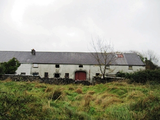
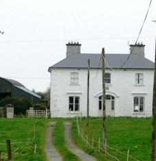
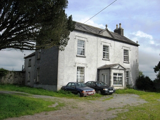
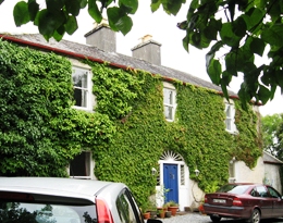
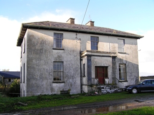
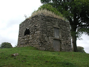
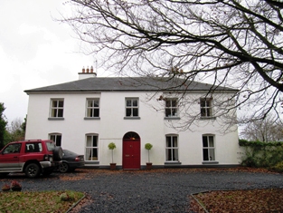
| Rathpeak House [Woodpark Lodge] | Owen Lynch was occupying the house at Rathpeak at the time of Griffith's Valuation when it was valued at £14. Lewis records Woodpark as his seat in 1837. This is also the property listed as his residence in 1814. At the time of the first Ordnance Survey in 1837 the house, known as Rathpeak House, is described as "a fine house, three stories high and in tolerable repair". When the property was advertised for sale in the Landed Estates' Court in 1861 Woodpark Lodge was described as a mansion house which originally cost several thousand pounds to build. There is now no sign of the house and there are modern farm sheds at the stables. Family history sources suggest the house was demolished in the latter years of the twentieth century. |
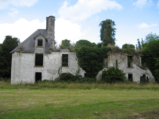
![Photo of Rathpeak House [Woodpark Lodge]](https://landedestates.ie/storage/img/orig/2807.jpg)
|
| Tully (Moycarn) | A house labelled as "Tully House" at Tully, barony of Moycarn, is shown on the first edition of the Ordnance Survey map adjacent to Tully Castle. It was described in the accompanying Name books as "a gentleman's place, a very good home in good repair". This townland was owned by James Thorngate at the time of Griffith's Valuation but the only house is valued at 10s. Tully Castle is labelled as "in ruins" on the 25-inch Ordnance survey map of the 1890s. In 1786 Wilson mentions "Tulleigh" as the beautiful seat of Sr R. St.George. | |
| Nutgrove | Taylor and Skinner record Nutgrove as a seat of the Donnellan family in 1783 and Wilson refers to it as the seat of Mr. Donnellan in 1786. At the time of Griffith's Valuation Anthony Nugent was leasing a property at Nutgrove or Feebrack, valued at £3 to Thomas Breheny. The site is now occupied by farm buildings. | |
| Clooncona | Laurence Mitchell was leasing a house valued at almost £4 at Clooncona, barony of Longford, from the Clanricarde estate at the time of Griffith's Valuation. There is still an occupied house at this site which in 2007 was offered for sale. Extensive nurseries are shown in this location on the 1st edition OS Map. |
|
| Longford House (Tirnascragh) | At the time of Griffith's Valuation, George Kenny was occupying a property valued at almost £7 at Longford. Hogan states that Longford House was built c.1844-1850. It passed from the Kenny family to Major Longbourne in the 1890s but Hogan records that he sold the estate in 1902. In 1906 the Congested Districts Board are recorded as the owners and the house was valued at £12 at the time. It passed to the Stoddart family in 1914 and is still extant and occupied. |
|
| Tristaun | At the time of Griffith's Valuation, Simon Sellers was leasing a property valued at £8, including a mill, from the Earl of Clancarty's estate. | |
| Chesterfield | A property named Chesterfield is recorded on the 1st edition OS Map, located at Cloonineen, parish of Kiltormer. At the time of Griffith's Valuation, Thomas S. Eyre owned this townland amounting to over 300 acres and also held a herd's house there valued at 15s. The property is still labelled Chesterfield on the 25-inch map of the 1890s but is much reduced. It is no longer extant. | |
| Lissanacody | The Pollok estate held a steward and caretakers' houses at Lissanacody, barony of Longford at the time of Griffith's Valuation, valued at £6 between them. In 1906 the property was part of the estate of the John Pollok's representatives and was valued at £7.Molloy writes that these buildings, which were unoccupied at the time, were damaged by fire in 1854. Some farm buildings remain at the site. | |
| Redwood House | Redwood was the home of the Bloomfield family in county Tipperary, occupied by Major Bloomfield in 1837. In 1840 the Ordnance Survey Name Books mention that Redwood was "a commodious house, at present occupied by a party of the constabulary and also the residence of Mr. Ryan, under-agent to Maj. Bloomfield". It is marked as a police station on the 1st edition Ordnance Survey map. At the time of Griffith's Valuation. Phillip Crawley held the property from Lord Bloomfield and the house was valued at £15. Redwood House later became a Trench home, valued at £18.15 shillings in 1906. It no longer exists. | |
| Harvest Lodge | The Stoneys were resident at Harvest Lodge from at least 1837. Thomas Johnston Stoney, born 1780, fourth son of Thomas Stoney of Arran Hill held the property in fee at the time of Griffith's Valuation, when the house was valued at £30. Harvest Lodge was the home of J.M. Wilson in the 1870s. This house no longer exists. | |
| Portland Park | A residence of the Stoney family from at least the 1770s, when it was purchased from the Earls of Antrim. Occupied by Richard Stoney in 1814 and by J. Chapman in 1837. In 1841 the Ordnance Survey Name Books described it as "a spacious building, the residence of Thomas B. Stoney with a great demesne". At the time of Griffith's Valuation he held the property in fee when the buildings were valued at £40. Portland Park remained in the possession of the Stoney family until it was burnt in 1936 (Irish Times, 11 May 1936). It is now a ruin. |
|
| Redwood | Marked on the first edition Ordnance Survey map as Moatfield House and on later maps as Redwood. Moate-field, Burris-a-kane, was the home of William Clarke in 1814. In 1841 the Ordnance Survey Name Books refer to it as "Moat Field, a good dwelling house the residence of Miss Clarke". In the mid 19th century Robert Daly held a house valued at £15 and 324 acres in Redwood from Lord Bloomfield. Redwood is still extant. | |
| Woodfield House (Donanaghta) | At the time of Griffith's Valuation, Timothy Egan was leasing a property valued at £7 from the Clanricarde estate. On the 25-inch map of the 1890s the house in this townland is labelled Woodfield. It is still extant and occupied. The first edition Ordnance Survey map notes an old brewery nearby. |
|
| Palmerstown Cottage (Lodge) | At the time of Griffith's Valuation, Timothy Joyce was leasing this property from the Palmer estate when it was valued at £5. It is still extant but not currently occupied. | |
| Newcastle (Kilconnell) | In 1786 Wilson refers to Newcastle as the seat of Mr. Davis. This townland was partly owned by the Longworths of Oatfield by the time of Griffith's Valuation. |