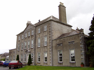
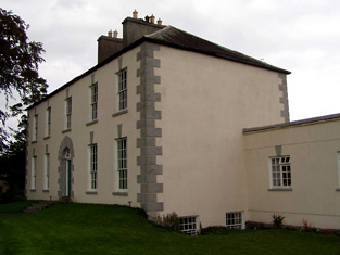
Deer Park
Houses within 10km of this house
Displaying 60 houses.
Houses within 10km of Deer Park
Displaying 60 houses.
| House name | Description | |
|---|---|---|
| Knockanacree Wood House | A house valued at £17+, occupied by Hawtrey Andrews and held from the Reverend Frederick F. Trench in the mid 19th century. Walford states that Hawtrey Andrews was the second son of Maunsell Andrews of Rathanny. This house is now demolished. | |
| Green Hills | The home of a branch of the Minchin family in the 18th and for part of the 19th centuries. The house was occupied by the Reverend William Minchin in the first half of the 19th century. It was valued at £34.15 shillings at the time of Griffith's Valuation and held in fee. The sale rental of 1851 describes the house as large and commodious and in good repair. Bought by a brother of one of the Reverend Minchin's son in laws Montague Blackett. This house no longer exists. | |
| Bantis | In 1814 Mr Kennedy is recorded as the proprietor of Bantis and Lewis mentions the extensive brewery of Edward Kennedy at Bantis in 1837. The Ordnance Survey Name Books record Bantis as "a neat dwelling house", the residence of Edward Kennedy. Buildings valued at £31+ and 526 acres at Bantis were held from the Honourable O.F.G. Toler by Edward, James, Denis, John and Patrick Kennedy and Henry Fitzgerald at the time of Griffith's Valuation. A house is still extant at the site. | |
| Camira | Occupied by the Reverend P. Bolton in 1837 and by William Jackson in the early 1850s, when the house valued at £11.14 shillings was held from Anne Crawford. In the possession of the Cole Bowen family in the later 19th century. This house no longer exists although a building is still located at the site. http://www.askaboutireland.ie/reading-room/history-heritage/big-houses-of-ireland/the-cole-bowen-estate/bowen-family-history/ | |
| Hermitage | This house was occupied by J.A. [John Andrew] Jackson at the time of Griffith's Valuation and held from his father Major Jackson. The house was valued at £20.16 shillings and was located close to the River Ollatrim. This house was renovated in the early 21st century. |
|
| Mount Pleasant | The main home of the Jackson family in the 19th century, occupied by John Short in 1814, by Captain Jackson in the 1830s and by Major Jackson in the early 1850s. The house with 448 acres was held from John Willington. The buildings were valued at £29+. Francis Freeman was the tenant in 1870. This house no longer exists. | |
| Castle Willington | Castle Willington was the seat of a junior branch of the Willington family of Killoskehane Castle. In 1786 Wilson refers to it as the seat of Mr. Willington. The Ordnance Survey Name Books note it as the seat of James Willington. Valued at £38+ it was held by James Willington in fee at the time of Griffith's Valuation. Alice C. Langford occupied this house valued at £20 in 1906. She was a daughter of John Willington and had married in 1877 Charles C. Coplen Langford. This house of 3 storys with tower house attached is still a residence. |

|
| Donnybrook | This house was the seat of a branch of the Poe family in the 18th and 19th centuries. William Poe was resident in 1814 and Lewis records him as the proprietor but the house was occupied by a tenant. The Ordnance Survey Name Books mention William Jackson as the occupier and describe the house as "large and commodious". At the time of Griffith's Valuation William Poe held the property in fee, the buildings were valued at £16.14 shillings. Donnybrook is still extant. |
|
| Wilton | This house located close to Donnybrook was vacant at the time of Griffith's Valuation and held by William Poe. It was valued at £10+. Earlier, in 1839, the Ordnance Survey Name books had noted it as the residence of John Poe but "out of repair at present". It no longer exists. | |
| Falleen | The home of the Hawkeshaw family in the 19th century, held from the Bowens of Bowens Court. Benjamin Hawkeshaw is recorded as the occupant in 1814 and in the early 1850s when the house was valued at £13.14 shillings. G. Riall was resident in 1837. The Ordnance Survey Name Books refer to Falleen as the seat of James Bennett in 1839. A house is still extant at the site. | |
| Knockane | Knockane was occupied by Mr William Cooke in 1814. In 1840 the Ordnance Survey Name Books describe it as " a commodious house the property of Mr. Hawkshaw". It was the residence of William Hodgens in the early 1850s, when the buildings were valued at £12.17 shillings and held from Robert Cole Bowen. A possibly later house is located at the site now. | |
| Pallas | The home of the Short family in the first half of the 19th century held from the Bowens of Bowens Court. John Short was resident in 1814 and 1837. The Ordnance Survey Name Books describe it as "a commodious dwelling with pretty demesne". It was occupied by Edmund Short at the time of Griffith's Valuation when the buildings were valued at £10. A farm is located at the site. | |
| Bessborough | In 1814 this house was occupied by John Mahon and in 1837 by T. Sadlier junior. The Ordnance Survey Name Books indicate that the proprietor was Mrs. Harding of Dublin and describe Bessborough as " a most beautiful house, occupied by Mr. Cushin, solicitor". By the time of Griffith's Valuation Dr John Armstrong was resident. He held the property from Mrs Harding and the buildings were valued at £20+. Jonathan Harding of Bessborough, Nenagh owned 163 acres in the 1870s. Slater refers to this house as the residence of David E. Young in 1894. It is still in use as a residence. |
|
| Woodville | Woodville was a home of a branch of the Minchin family from the mid 18th century. The Reverend James Poe was resident at Woodville, Nenagh, in 1814 and Lewis records Humphrey Minchin as the proprietor in 1837. The Ordnance Survey Name Books mention that it had "by far the most beautiful demesne in the parish". He is also recorded as the occupier in Griffith's Valuation when the house was valued at £20.14 shillings and held in fee. When advertised for sale in 1869 James J. Poe was given as the tenant under the Court of Chancery. The house was described as containing a basement story, three large sitting rooms and five principal bedrooms. In 1906 occupied by Alice M.M. Bunbury. George W. Bunbury of Woodville owned 516 acres in the 1870s. |
|
| Clermont House | Clermont or Claremount House, Nenagh, was occupied by William Short in 1814 and by Frederick Evans in 1837. In 1840 the Ordnance Survey Name Books refer to it as "a good dwelling house, the residence of Mr. J. Evans". It was also occupied by Evans at the time of Griffith's Valuation. The house was then valued at £24 and held from the Marquess of Ormond. This house still functions as a residence. |
|
| Bellpark | Occupied by T. Robinson in 1837. The Ordnance Survey Name Books record Eyre C. Baldwin as the proprietor in 1840. It was occupied by Thomas Goold in the early 1850s. Goold held the house valued at £17+ with 116 acres from Denis Leonard and was the tenant at the time of house of the 1852 sale. A house is still extant at the site. | |
| Bellgrove | The home of the Leonard family in the first half of the 19th century. The Ordnance Survey Name Books refer to Geoffrey Leonard as the proprietor in 1840 but note that the house was not inhabited. It was held by Denis Leonard in fee at the time of Griffith's Valuation when the buildings were valued at £25.10 shillings. This house was unoccupied at the time of the 1852 sale. It appears to have been bought by Hyacinth Richard Daly, who advertised it for sale again in 1863. The sale rental states that the dwelling house was in "an unfinished state". Bellgrove no longer exists. | |
| Lisbryan | Lisbrien or Lisbryan, near Ballingarry, was occupied by Faulkner Esq in the 1770s and 1780s. Sir Robert Waller Baronet was occupying this house in 1814. Lewis records T. Bunbury as the proprietor in 1837. The Ordnance Survey Name Books, also refer to it as his residence, "a very extensive building of the modern style". Thomas Bunbury held the property from Lord Ashtown at the time of Griffith's Valuation when the buildings were valued at £40+. Lisbryan is still extant. |

|
| Ballymona | Ralph Smith was resident at Ballymona in 1837 and in the early 1850s. The Ordnance Survey Name Books refer to the house as " a plain modern building" in 1841. Smyth held the property from Lord Ashtown and the buildings were valued at £25. This house is now a ruin. | |
| Fairyhill | Fairyhill was the home of William Henry Cox in 1837. The Ordnance Survey Name Books describe it as "a large mansion house, the residence of Mr. Cocks [sic]" in 1841. It was occupied by Ellen Robinson in the early 1850s, when the house was valued at £19 and held from Lord Ashtown. Valued at £16 in 1906 and held by George W. Robinson. This house is still in use as a residence. |

|
| South Park | In the 1770s Abbot Esq was residing at Rahanane close to Ballingarry. Wilson, writing in 1786, also refers to Rahanane as the seat of Mr. Abbott. The house is named South Park on the 1st edition Ordnance Survey map and was the home of a branch of the Atkinson family, occupied by Anthony Atkinson in 1814 and by C. Atkinson in 1837. Charles Atkinson held the property from Lord Ashtown at the time of Griffith's Valuation when the house was valued at £22. The estate of Edward Evans of Southpark, 174 acres in the barony of Lower Ormond, was advertised for sale in December 1859. South Park is still extant. |
|
| Ballingarry | Situated just north of Ballingarry castle Ballingarry House was built circa 1820. Lewis records Marmaduke Thompson as resident at Ballingarry Castle in 1837 as does the Ordnance Survey Name Books in 1841 though they refer to Lord Ashtown as the proprietor. The Thompson interest in Ballingarry and Ballinahinch was for sale in June 1850. Henry Trench was the occupier in the early 1850s holding the property form Lord Ashtown. Ballingarry House is still extant and occupied. |
|
| Ballinderry | Occupied by the Saunders family from at least the 1770s. Owen Saunders was resident in 1814. He was related to the Sadleirs of Ballinderry. Lewis records Thomas Sadlier junior as the proprietor of Ballinderry "on which a house was about to be erected". Thomas Sadlier held the property in fee at the time of Griffith's Valuation when the buildings were valued at £29. At the time of the Saunders sale in 1877 this house was described as modern and substanial and "approached by a noble avenue lined with beech trees". It was in the owner's possession. Occupied by William J. Russell in 1906. This house is still a residence. | |
| Sopwell Hall | Apparently named after an English property, Sopwell in Hertfordshire, which was inherited by the Sadleir family. In 1655 a Cromwellian soldier, Colonel Thomas Sadleir, was granted Kinelagh Castle, county Tipperary, which he renamed Sopwell Hall. This property remained in Sadleir possession until it was inherited by Mary Sadleir who, in 1754, had married Frederick Trench of Woodlawn, county Galway, the parents of the 1st Lord Ashtown. The present house was built by Mary's father, Francis Sadleir, in the mid 18th century. Wilson refers to it as the residence of Mr. Sadlier in 1786. Sopwell Hall was left to Francis Trench, brother of 1st Lord Ashtown, who was living at Sopwell Hall in 1814. In 1837 Lewis records the Trenches in possession and writes that "on the demesne are the ruins of the ancient castle formerly occupied by the Sadleir family". The Ordnance Survey Name Books, in 1840, refer to Sopwell as "a spacious building, the residence of Stewart Trench". At the time of Griffith's Valuation the 2nd Lord Ashtown, son of Francis, was occupying the house, valued at £40 and held by him in fee. By 1906 Sopwell was valued at £80 and occupied by the Honourable Cosby G. Trench. The Trench family were still resident at Sopwell Hall in the 1970s. In 1840 the Ordnance Survey Name Books noted that Sopwell was one of the largest demesnes in the country. |

|
| Killavalla | Lewis records Killavalla as the seat of R. Johnston Stoney. The Ordnance Survey Name Books refer to the house in this townland as "Honeywood House, the residence of Robert Johnstone Stoney, very commodious with convenient offices attached". Stoney's representatives held the property valued at £16+ from the representatives of Stephen Egan at the time of Griffith's Valuation. It later became the seat of the Saunders family. This house no longer exists. |
|
| Greyfort Cottage [later Greyfort House] | The Stoneys were residing at Greyfort from at least the 1770s as recorded by Taylor and Skinner and also by Wilson in 1786. A house known as Greyfort Cottage was marked on the first edition Ordnance Survey map at this location and is also mentioned in the Ordnance Survey Name Books which refers to it as "a good dwelling house, the residence of Henry Owen Saunders". On later maps a different building in the townland is known as Greyfort House. Biggs A. Stoney was living at Grey-fort, Borrisokane, in 1814 and Saunders is recorded as the proprietor by Lewis. William Gray was the occupier of a house in Greyfort townland, valued at £12+, at the time of Griffith's Valuation and held from Henry O. Saunders. Thomas R. Grey of Greyfort House owned 500 acres in the 1870s. Buildings are still extant at this site. | |
| Ballyrickard House | Ballyrickard may possibly be the house known as Lettyville on the Taylor and Skinner map from the 1770s. Leet records Daniel Falkener as resident at Ballyrickard in 1814 and Lewis records N. Falkiner as the proprietor. The Ordnance Survey Name Books refer to Ballyrickard as "a commodious house", the residence of Nathaniel Falkiner. In the early 1850s Addison Hone was the occupier holding the property from Richard H. Falkiner. The buildings were valued at £15. This 18th century house is still extant and occupied. |

|
| Congor | Occupied by F. Falkiner in 1837 and described by the Ordnance Survey Name Books as "the commodious residence of Nicholas Biddulph" in 1840. It was still occupied by him at the time of Griffith's Valuation when the house was valued at £20. Nicholas Biddulph was still resident in the mid 1870s when he is recorded as owning 74 acres in county Tipperary. A building is still located at this site. | |
| Beechwood Park | Beechwood, near Nenagh, was occupied by Richard C. Langford in 1814 and Lewis writes that Beechwood was the property of Colonel Toler Osborne but was occupied by D. Falkiner and had once been the residence of the Earl of Norbury. Wilson, writing in 1786, refers to "Beech Wood, the fine seat of Daniel Toler". In the mid 19th century William Osborne was resident, holding the property in fee. The buildings were valued at £33. Occupied by Lady Osborne in 1906 when the buildings were valued at £40+. The home of Philip Blake, genealogist, in the mid 20th century. This mid 18th century house still functions as a country house. |
|
| Mount Falcon | Bence Jones writes that this house was built in 1720 by Richard Falkiner. It was the seat of the Falkiner family in the 18th and 19th centuries. The Ordnance Survey Name Books refer to it as the seat of Richard Fitzpatrick Falkiner (a minor) in 1840 and that it was occupied by Obediah Holan. At the time of Griffith's Valuation the house was valued at £15. It is still extant. |

|
| Clifton | Lewis records Clifton as the seat of Captain Sheppard. The Ordnance Survey Name Books refer to it as "a modern building, the residence of Capt. Sheppard" in 1841. Arthur Sheppard [?] was the occupier at the time of Griffith's Valuation. He held the property from Thomas Pyke and the buildings were valued at £14.10 shillings. The National Inventory of Architectural Heritage records the present house as dating from 1868. |
|
| Bushy Park | Bushy Park was the home of Thomas Towers in 1814 and in 1837. In 1840, the Ordnance Survey Name Books refer to it as " a comfortable house, the residence of Thomas Towers" and also include reference to a letter written by Mr. Towers in which he expressed the wish that the house would revert to the name Shesharaghmore house though this does not seem to have happened. Sarah Cambie was occupying the house valued at £15 and held from Thomas Towers in the mid 19th century. David Clarke is described as "of Bushy Park, Borrisokane and Macclesfield" in the 1870s. Still valued at £15 this house was held by the representatives of David Clarke in 1906. A building is still extant at the site. | |
| Behamore | The Reverend Thomas Hawkshaw was resident here in 1814 and Benjamin Hawkshaw in 1837. The Ordnance Survey Name Books also note it as his residence, describing Behamore as "a commodious house". James Fleetwood was the occupier in the early 1850s holding the property from Lord Dunalley, it was valued at £13+. A building is still located at this site. | |
| Lacka | Lewis records W. Cruess as proprietor of Lacka in 1837. On the first edition Ordnance Survey map a small house named Ash Grove is marked in the townland of Lacka S024 979. Later maps mark Lacka House at the crossroads. Griffith's Valuation names William N. Cruise as the occupier of a house valued at £10 in Lacka. He held the property and 335 acres from William Abernethy. The buildings were valued at £10. In the 1870s Samuel R. Cruess of Lacka owned 365 acres and William V. Cruise of Nenagh owned 121 acres. | |
| Ballynavin | According to the National Inventory of Architectural Heritage the origins of this building date back to the mid 17th century. Ballynavin was a Robinson home in the 19th century, occupied by Mrs Robinson in 1837 and by Reverend Robert Robinson in the early 1850s. He held the property in fee and the buildings were valued at £18. Robert Robinson lived at Ballynavin in the 1870s. The house is still in use as a residence. |

|
| Wingfield | A house located just inside the county Tipperary border with county Offaly. The property belonged to John Shortt in the mid 18th century. When he died in 1768 his widow Frances (nee Spunner) married Jonathan Doolan. Wingfield was occupied by Jonathan's son Thomas Doolan in 1814 and in 1837. The Ordnance Survey Name Books refer to it as the residence of [Paliner?] Thomas Doolan in 1840. By the time of Griffith's Valuation Henry Spunner was resident. He held the property from Jonathan Short and the buildings were valued at £20. Richard Thomas Croasdaile and his sister Margaret occupied the house in 1901. This house is now a ruin. |
|
| Northland | Northland was the residence of Sir A. Dancer in 1814 and of William Smith in 1837. By the time of Griffith's Valuation William Henry Head occupied this house valued at £10. He held the property from Lord Dunalley. The house was demolished by the early 20th century. | |
| Willow Lodge | James Fleetwood was resident at Willow Lodge in 1814 and in 1837. By the time of Griffith's Valuation the house appears to be only valued at £1 and occupied by David Tierney. Willow Lodge is marked on the first edition Ordnance Survey map. It is named Alma on the 25-inch map of the 1890s. There is still an extant house at the site. | |
| Riversdale | This house was built after the first Ordnance Survey. At the time of Griffith's Valuation Thomas S. D. Robinson is recorded as the occupier of a house valued at £15 in the townland of Ballynavin. He held the property in fee. Thomas S.D. Robinson was still living at Riversdale in the 1870s. This house continues to be used as a residence. |

|
| Cloghkeating | The home of Augustus Robinson from the 1830s. The Ordnance Survey Name Books refer to Cloghkeating as "a large new house" in 1841. At the time of Griffith's Valuation Augustus Robinson held the property in fee and the buildings were valued at £19. Augustus Robinson of Cloghkeating owned 231 acres in the 1870s. This house is still in use as a residence. |

|
| Cloghjordan House | This house was the home of the Reverend Edwin Palmer in 1814. By the time of Griffith's Valuation John Hodgins occupied the house and ran the nearby nursery gardens. The buildings were valued at £13+ and held from Lord Dunalley. This building which includes the remains of the old castle still functions as a country residence. |
|
| Tenessee | This house is labelled Tenessee House on both the First and 25-inch edition Ordnance Survey map. In 1841 the Ordnance Survey Name Books suggest that it was the property of Lord Dunally. In the mid 19th century it was occupied by Thomas R. Barnes and held from Joseph Falkiner. The buildings were valued at £14. 15 shillings. The house is still in use as a residence. |

|
| Coolnamunna | At the time of Griffith's Valuation Edward Kennedy held buildings valued at £34+ from Ellen Lloyd [widow of Henry Jesse Lloyd of Castle Iney?] in the townland of Coolnamunna. He had a distillery in Mullenkeagh valued at £47. Edward Kennedy of Coolnamoner Park owned 432 acres in county Tipperary in the 1870s. |
|
| Glenahilty | William Kennedy was occupying Glenahilty from at least 1837 when Lewis records him as resident althought the property belonged to J.C. Fitzgerald. The house was valued at £6.10 shillings at the time of Griffith's Valuation and was held with 189 acres of land and 210 acres of bog from Fitzgerald. | |
| Fort William | A Parker residence in the early part of the 19th century. In 1841 the Ordnance Survey Name Books referred to it as "a splendid demesne and fine mansion house, the residence of Mr. Parker". By the time of Griffith's Valuation Fort William was occupied by Miss Crawford who held the property from Messrs Egan. The buildings were valued at £18.15 shillings. The Egan sale rental of 1854 gives details of the original lease which was from Charles Egan to John Greene in 1769 for three lives renewable for ever. The last renewal was dated 1803 from John Egan to William Crawford. This house is still in use. |

|
| Modreeny House | In 1786 Wilson refers to "Moderenny" as the seat of Sir Amyrald Dancer. The Ordnance Survey Name Books refer to the house as Eminisky House in 1841 but it is marked on the first edition map as Modreeny House and was the home of the Dancer family. It was replaced by a new house circa 1920s. The outbuildings, gates and gatelodge of the original house still remain. At the time of Griffith's Valuation Sir Thomas B. Dancer held this property in fee. The buildings were valued at £21. Hussey gives Modreeny House as the address of Sir Thomas Dancer in 1878. |
|
| Hilton | Hilton, located just to the south of Modreeny House, was the home of Thomas Dancer, later 6th Baronet, in 1837 and of the 6th Baronet's son, Thomas J. Dancer, in the mid 19th century. Thomas J. Dancer held the house valued at £15 from his father Sir Thomas B. Dancer, 6th Baronet. In 1841 the Ordnance Survey Name Books had noted the house as the residence of Thomas Stoney. A house is still located at this site. | |
| Elysium | This house is marked on the first edition Ordnance Survey map and was inhabited by Thomas Ely in 1837. Thomas Ely held the property in fee at the time of Griffith's Valuation when the house was valued at £23. The Elys were still resident in the 1870s. George Evans was occupying this house in 1906. There is still a house located at this site. | |
| Modreeny | Lewis records W. H. Head as the proprietor of Modreeny House in 1837. He was still resident at the time of Griffith's Valuation and held the house valued at £35 in fee. Burke's ''Landed Gentry of Ireland'' (1904) records William Henry Head's father as "of Modreeny House". In 1906 the representatives of George Whitfield were the occupiers and the house was valued at £36.10 shillings. George Whitfield of Modreeny owned 443 acres in the 1870s. In 1890 his daughter Kathleen married Sir Francis Osborne, Baronet. This house was bought by Donald Swan in 1965 and Charlie Swan, champion jockey, was born at Modreeny in 1968. |
|
| Mertonhall | Merton, Cloghjordan, was the home of T.G. Fitzgibbon in 1814. It was purchased by Robert Hall in 1828 and he was the proprietor in 1837. The Ordnance Survey Name Books noted in 1841 that it was formerly known as "Litty Ville House". The house was valued at £55 at the time of Griffith's Valuation and held by Robert Hall in fee. The Hall family continued to use Merton as a residence in the 1870s. By 1906 the representatives of De Courcy P. Ireland were occupying Mertonhall. He was married to Ada Hall. This house is now demolished. | |
| Coorevin | Lewis records Cooreavan as the property of R. Hall in 1837. In 1840 the Ordnance Survey Name Books indicate that it was occupied by "Mr Gorey Baker, Burresokane". Jeremiah P[ierce] Scully was the occupier at the time of Griffith's Valuation, holding the property from the representatives of Robert Hall. The buildings were valued at £11. A building is still located at this site. | |
| Uskane | Carrol Esq was resident at "Iscane" in the 1770s and 1780s. In 1837 R. Hall was the proprietor of Uskane House. In 1840 the Ordnance Survey Name Books note it as "a good dwelling house, the residence of Mr. Kent". It was held by the representatives of Robert Hall in fee at the time of Griffith's Valuation when the house was valued at £8. This house is still in use as a residence. |
|
| Fort Nisbitt | Robert Nesbett was resident at Fort Nesbett in 1814. The Ordnance Survey Name Books also mention him in 1839 though they refer to Thomas Towers as the proprietor of the townland. In the early 1850s, Thomas O'Brien was the occupier, holding the property from the Reverend James Nesbitt. The buildings were valued at £12.15 shillings. A building is still located at this site. | |
| Castle Sheppard | The Sheppards were living here from at least the 1770s.In 1786 Wilson refers to Castle Sheppard as the seat of "Mr. Shepherd". It was the home of a junior branch of the family. William Sheppard was resident in 1837 and in the early 1850s when the house was valued at £26 and held from Lord Ashtown. William died at Castle Sheppard in 1852 without heirs and both his brothers died unmarried in India. Valued at £18 in 1906 and occupied by the Honourable Cosby G. Trench. This house is now a ruin. | |
| Lisheen (Lower Ormond) | In 1840 the Ordnance Survey Name Books refer to Lisheen House in the parish of Aglishcloghane as held by John Crawford but an addendum to the entry on the parish of Uskane note that Lisheen was the residence of Geo.Fosbery, Jnr. By the time of Griffith's Valuation it was held in fee by George Fosberry and valued at almost £8. A house is still extant at the site. | |
| Ballymackey House | Ballymackey House is described as "in ruins" at the time of the first Ordnance Survey in the 1830s. An earlier tower house is also shown, described as "Ballymackey Castle (in ruins)". Wilson, writing in 1786, refers to "Ballymakey" as the seat of Mr. O'Meara. The Ordnance Survey Name Books describe Ballymackey House as "an old house adjoining the south side of Ballymackey old castle.....now in a state of total ruin". By the time of Griffith's Valuation, this townland was part of the Cole-Bowan estate. Most of the site is now occupied by extensive farm sheds though ruins of the old castle are still visible. | |
| Elm Hill House | The Ordnance Survey Name Books record William Middleton as the occupier of Elm Hill House in 1839 and mention the surroundings as "a very pretty demesne situated in a beautiful locality". At the time of Griffith's Valuation, William Middleton was leasing this property from the Poe estate when the house was valued at almost £8. The original house is no longer extant and a modern house has been constructed at the site. | |
| River Lawn | In 1839, he Ordnance Survey Name Books describe River Lawn house as "a commodious house, the property of William Poe, in the occupation of E. Radford esq". At the time of Griffith's Valuation, when it was valued at almost £10 it was leased by Augustus H. Going from William Poe. It is still extant and occupied. |
|
| Mill Grove House | In 1841, the Ordnance Survey Name Books describe Mill Grove House as " a good house with demesne and plantations, the residence of Mr. Kennedy". At the time of Griffith's Valuation, Edward Kennedy was leasing a substantial milling complex and a house at this location from the Stoney estate. The buildings had a value of £46+. It is labelled Millgrove House on the 25-inch map of the 1890s but is no longer extant. | |
| Fort Henry [Greyfort Cottage] Borrisokane | In 1840, the Ordnance Survey Name Books refer to "Fort Henry, a commodious house, the residence of Henry Ely" in the townland of Greyfort, parish of Borrisokane. At the time of Griffith's Valuation, Henry Ely was leasing a property valued at almost £5 from the Saunders estate in this townland. This may refer to the property shown on the 1st edition Ordnance Survey map as Greyfort House. On the later 25-inch map of the 1890s it is known as Greyfort Cottage. A house is still extant at the site. |