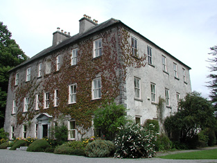
Burke's Court
Houses within 10km of this house
Displaying 45 houses.
Houses within 10km of Burke's Court
Displaying 45 houses.
| House name | Description | |
|---|---|---|
| Portumna | Reverend Lewis Hawkes was leasing a property at Portumna, valued at £16 from the Ecclesiasical Commissioners at the time of Griffith's Valuation. The Reverend Louis Hawkes of Brierfield died in 1857. A house still exists at the site. | |
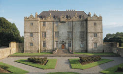
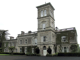
| Portumna Castle | The house we know as Portumna Castle was built in the early seventeenth century by Richard de Burgo or Burke, 4th Earl of Clanricarde. It was used as the de Burgo/Burke family residence for over 200 years until it was badly damaged by fire in 1826 when it was replaced by another house close by. This second house is no longer extant. In 1906 the buildings at Portumna were valued at £40. The original Portumna Castle has been restored and is open to the public. |
|
| Pallas | Pallas was the largest of the Nugent properties in the parish of Tynagh, which also included Spring Garden, Flower Hill and Crannagh, a property that had been used in the eighteenth century. A mansion was built at Pallas for Anthony Nugent, 4th Lord Riverston, in 1797. Slater, in 1846, refers to the Hon. Anthony Nugent residing at "The Palace". At the time of Griffith's Valuation it was the property of Anthony Nugent and was valued at £46. In 1906 it was owned by the Earl of Westmeath and was valued at £52. It was demolished after World War II. A well-preserved tower house and the remains of a large 17th century residence can also be seen at Pallas. |

|
| Tintrim | Up to 1898 this house was in the barony of Leitrim, county Galway. It is now in the barony of Tulla Upper, county Clare. At the time of Griffith's Valuation, John A. Burke was occuping the house valued at £11, at Tintrim, parish of Clonrush, barony of Leitrim, county Galway. Weir states that the house at Tintrim was probably built by John Anthony Burke of Clondegoff Castle nearby. He was most likely a member of the Burke family who lived at Meelick House, Whitegate at the same time. Tintrim continued in the possession of the Burke family as John Anthony Burke moved out to allow his son, Edmund, and his family to live there until the house was sold in 1867. The house later passed to the Madden family and is still extant and occupied. The Irish Tourist Association file records state that John A. Burke died in 1857 though the family history suggests he died in 1863. The Tourist Association file also notes that in 1933 there was a search for the heirs of his reputed son, Martin Edward Burke, in Australia. |
|
| Shannon Hill (Derryvunlam) | Edward Matthews occupied Shannon Hill House at Derryvunlum, barony of Leitrim, at the time of Griffith's Valuation when it was valued at £18. In 1906 the house at Derryvunlam, known as Shannon Hill, was still valued at £18 and still in the hands of Edward Matthews. There is still an extant house at the site. |
|
| Earlstown | In 1786 Wilson refers to "Capasell" s the seat of Mr. Devenish [?]. The house at this location is labelled Earlstown on the 1st edition Ordnance Survey map. In 1846 Slater refers to Robert Grace resident at Earlston. Robert Eyre was leasing a property in the townland of Cappasallagh, parish of Kilmalinogue, barony of Longford, valued at £11 from the Clanricarde estate in 1856. There are still occupied buildings at this site, the focus of a large farming enterprise. |
|
| Gurtray/Gortrea/Gortray/Fairfield | Writing in 1786 Wilson refers to this house as Fairfield, the seat of Mr. Hamilton. Ambrose O'Kelly was the owner of a house valued at £20 in Gortrea or Fairfield, parish of Kilmalinoge, barony of Longford, county Galway in 1856. Slater refers to "Gurtray" as the seat of John Appleyard O'Kelly in 1894. In 1906 this house was the property of John A. O'Kelly. According to family tradition the house lost its roof on the Night of the Big Wind in 1839. It is still extant and occupied and in 2007 was offered for sale. |
|
| Fairy Hill | Thomas Doolan was leasing a property at Fairy Hill, valued at £20, to Charles Cooper at the time of Griffith's Valuation. Slater had noted it as the residence of Thomas Doolan in 1846. In 1894 Slater records Fairy Hill as the seat of Colonel Cheevers. This house is still extant. |
|
| Palmerstown ( Pokoroko) | In 1814 a house at Fairy Hill was the residence of Mr. Palmer. This property was held on a lease renewable forever from the Clanricarde estate. It is recorded in Lewis under Portumna town. In 1865 it was occupied by Lewis Goodbody who had purchased it in the Landed Estates Court in 1861. The sale notice refers to the house as "Pokoroko" and this title appears again in the Cunningham sale report of June 1886. However on both the 1st and 25-inch editions of the Ordnance Survey map it is labelled Palmerstown House, the name by which it is still known. It is still extant and occupied. |
|
| Thornfield | Slater refers to Thornfield as the seat of John Davis in 1846. In 1856 Thomas Galbraith was leasing a property valued at £7 in the townland of Thornfield, parish of Lickmolassy, barony of Longford, from the Clanricarde estate. It is no longer extant. | |
| Gortaha House | Cuthbert Featherston held a property valued at £10 in the townland of Gortaha, parish of Lickmolassy, barony of Longford, in 1856. It is labelled Gortaha House on the 1st edition Ordnance Survey Map. The 25-inch map of the 1890s records that it was "in ruins" and very little now remains. | |
| Willmount or Gortnacloghy | In 1856 Matthew McDonagh was leasing a property valued at £19 in the townland of Gortnacloghy, parish of Lickmolassy, barony of Longford, from the Clanricarde estate. This house was also known as Wilmount or Wellmount. |
|
| Oakley Park | At the time of Griffith's Valuation, John Cunningham was leasing a house valued at £13 at Gowil, parish of Lickmolassy, from Anne Shewbridge. This appears to be the house known as Oakley Park, occupied in the 1870s by the Pigot family. It is still extant and occupied. |
|
| Killeen House (Portumna) | Killeen House was the birthplace of Mary Anne Kelly, otherwise known as Eva of the Nation. The house was the property of her father Edward Kelly. In 1837 Lewis recorded it as the seat of E. Kelly. At the time of Griffith's Valuation it was valued at £18. Extensive corn mills are shown at the site on the First Edition Ordnance map. Killeen House is still extant. |
|
| Oghilly | At the time of Griffith's Valuation, Michael Page was leasing a house at Oghilly, parish of Ballynakill, barony of Leitrim, county Galway from the Clanricarde estate. It was valued at £9. The National Inventory of Architectural Heritage suggests that this house dates from the 1770s. It is still extant and occupied. |

|
| Silverstream House | At the time of Griffith's Valuation John Shaughnessy was leasing a property valued at £5 from the estate of John Aylward, which was the subject of chancery proceeding. A building still exists at the site. | |
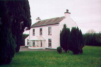
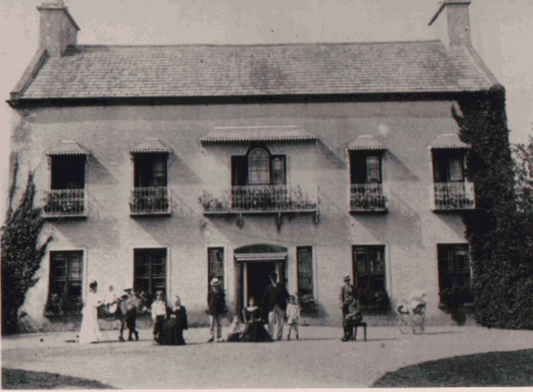
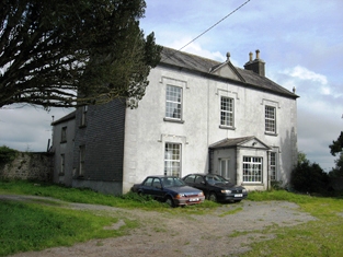
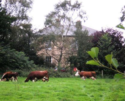
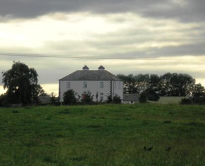
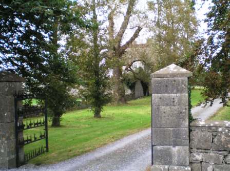
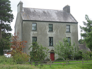
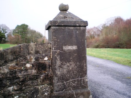
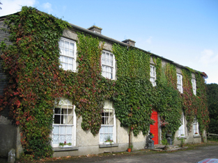
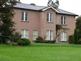
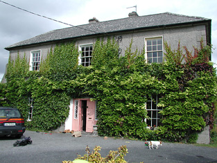
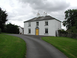
| Clonco House (Burke's Court) | Edward Burke was occupying this house valued at £8 at the time of Griffith's Valuation. In 1837 Lewis recorded it as the seat of Ulick Burke. On both the 1st and 25-inch edition Ordnance Survey maps, this house is labelled Burke's Court. In 1906 it was owned by John K. Burke and was valued at £7. The original entrance gates, showing Cloncoe House, are still extant and there is still a house at this site. |
|
| Eagle Hill | Eagle Hill was leased from Andrew Martin by Henry Pigott at the time of Griffith's Valuation when it was valued at £20. In 1837 Lewis recorded Eagle Hill as the seat of Capt. H. Pigot. It was recorded as the residence of A.P. Martin in 1814. In 1906 Anne Martin was the owner when the buildings were valued at almost £16. It is still extant and occupied. |
|
| Edward's Lodge | The 1st edition OS map shows a house called Edward's Lodge, at Derrylahan, barony of Leitrim, county Galway. This appears to be the property, valued at over £1, leased by the Aylward estate to Patrick Mohan at the time of Griffith's Valuation. There are not buildings at the site now and the area is heavily forested. | |
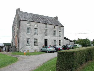
| Castle Biggs/Drominagh | The Smythe sale rental of July 1870 states that the original lease (1711) was from Godfrey Boate and Benjamin Friend to William Biggs. Built by the Biggs family on the shore of Lough Derg this house was occupied by William L. Biggs in 1814 and by Dr W. Biggs in 1837. In 1840 the Ordnance Survey Name Books refer to Castle Biggs as "a most commodious house". Edward Biggs was resident in the mid 19th century, holding the property from Sir John Power. The house was valued at £22. The sale rental of November 1853 describes this "3-storey mansion containing every necessity and a range of out offices". It was in the possession of Edward Biggs, the owner, and was bought by Captain William Tuthill. William Tuthill sold the property to Frederick Smythe in 1859. It was for sale again in July 1870. At this time the Esmondes of county Wexford bought it from Frederick Smythe. In the early 1940s owned by Owen Esmonde but purchased by the Moss family in the 1940s. It is still extant. |
|
| Drominagh Lodge | According to the sale rental of November 1853 Dr Frederick Biggs had built a handsome residence in Shanakill for a sum exceeding £1,000. Drominagh Lodge is marked on the first edition Ordnance Survey map. Griffith's Valuation records Frederick Biggs as the occupier of the house valued at £13. He held the property from Edward Biggs. This house has been the home of the Fogarty family since the late 19th century. |
|
| Gortmore | The sale rental states that Robert Biggs built this house for about £800 in the mid 19th century. It is not marked on the first edition Ordnance Survey map. Griffith's Valuation records Samuel Biggs as the occupier of the house, valued at £11 and held from Edward Biggs. The sale rental of November 1867 advertised the sale of a valuable leasehold, the estate of Samuel and Robert Biggs, at Gortmore (222 acres and dwelling house). The 22[2?] acre estate of Samuel Biggs at Gortmore was sold to John Samuel Clarke, the petitioner, in November 1867 for £650 (The Irish law times and solicitors' journal: Volume 1, 1868 - Page 679). A house is still located at this site. | |
| Spring Park | In the mid 19th century Benjamin Armitage occupied a house valued at £10 in Gortnagrann which he held with 243 acres from William Woods. The Ordnance Survey Name Books note it as being occupied by Mr. Armitage in 1841. The site is now occupied by farm buildings. | |
| Castletown | ''Burke's Irish Family Records'' states that Castletown was purchased by Thomas Sadleir of Sopwell Hall from the family of his brother-in-law, John Briggs of Castletown, in 1706. It passed to Charles, the second son of Thomas Sadleir and was in the possession of his descendants for four generations. In 1747 it was leased to the Cambies by Charles Sadlier. Wilson mentions it as a Parker seat in 1786. In 1814 Leet records the house as unoccupied. C. Cambie was the occupier when Castletown was described by Lewis as a “a handsome castellated building”. Charles Cambie held Castletown from Thomas Sadlier at the time of Griffith's Valuation when the house was valued at £23. Castletown was sold in the Encumbered Estates Court in 1856, Miss Sarah Cambie was the tenant. Thomas Towers of Bushy Park, Borrisokane was the petitioner. He was married to Elizabeth Cambie and Castletown became their home. In 1906 the occupant was Thomas Towers and the house was valued at £24+. In the 1940s Miss Towers and her nephew Mr. Sterling were the occupiers. This 17th century fortified house with early 19th century additions is still in use as a family residence. It was also known as Castle Cambie. |
|
| Kyle Park | Marked on the first edition Ordnance Survey map Kyle Park was occupied by Thomas G. Stoney at the time of Griffith's Valuation and held by him in fee. It was valued at £39. The Ordnance Survey Name Books had described it as " a new and commodious house built and occupied by T.G. Stoney". The Stoneys still lived at Kyle Park in the 1870s. This house is still extant. |
|
| Arranhill | Arranhill was a Stoney home in the late 18th century. Thomas Stoney was resident in 1814 and Thomas George Stoney in 1837. In 1840 the Ordnance Survey Name Books report that "it suffered considerable damage during the storm of 6 and 7 January, 1839. It is occupied at present by Mr. Skelly, land steward to George Walpole, Brusna Mills, Roscrea". The Name Books also note the Marquis of Ormond as the proprietor. Thomas G. Stoney was the occupier in the early 1850s holding the property from the representatives of T.P. Firman. The buildings were valued at £23.10 shillings. This house is described as "in ruins" on the 25-inch Ordnance Survey map of the 1890s and some of these ruins remain. | |
| Firmount | The seat of the Firman family in the late 18th century, occupied by Thomas P. Terman in 1814. The house is marked on the first edition Ordnance Survey map. The Ordnance Survey Name Books refer to it as "the mansion house of Firmount now falling into ruins, It appears to be a ruin by the time of Griffith's Valuation. The only buildings over £10 valuation were the Santa Cruise flour mill and house of Samuel Palmer. The Irish Tourist Association surveyor records "an extremely charming house converted from stabling" at Firmount and occupied by Major H.H. Deasy in the early 1940s. The surveyor states that the original house was destroyed by fire. | |
| Oldcourt | John Brereton of Oldcourt was the second son of John Brereton of Rathurles and his wife, Margaret Watson. He had a son,John, born 1817. The Ordnance Survey Name Books refer to it as his property in 1840 but mention that it was "a commodious house" occupied by his land steward. John Brereton held Oldcourt in fee at the time of Griffith's Valuation when the house was valued at £12. A building is still extant at this site. | |
| Rodeen | A Falkiner residence from at least 1837. It was the home of Joseph Falkiner who held the property in fee. He was one of the eleven sons of the Reverend R.D. Falkiner of Mount Falcon. The house was valued at £22. It was advertised for sale in July 1860, Mrs Anne Falkiner and Richard J. Falkiner were the tenants. The house came on the market again in May 1867, part of the 105 acres for sale at Rodeen, the estate of Octavius La Touche. This house is still in use as a residence. |

|
| Annagh | Annah was the residence of J. Minchin in 1837 and was held by John Minchin in fee in the mid 19th century when the buildings were valued at £18.10 shillings. Falkner J. Minchin was the occupier in 1906 and Commander Minchin in the early 1940s. Named on the first edition Ordnance Survey map as Annagh Lodge. This house is still a residence. |
|
| Bellevue | Belview, Nenagh, was the residence of G.W. Biggs in 1814 and in 1837. The Ordnance Survey Name Books note that Thomas Sadlier was the proprietor of Bellevue inn 1840 but that it was the residence of J.W. Biggs and was " a commodious house". Samuel D. Biggs was the occupant at the time of Griffith's Valuation. He held the house valued at £30 with 315 acres from Thomas Sadlier. Samuel D. Biggs was still resident at Belview in the 1870s. Major Biggs lived at Bellevue in the 1940s. Bellevue is still extant. |
|
| Brookfield | D. Cambie is recorded as the proprietor of Brookfield, Nenagh in 1814. The Ordnance Survey Name Books refer to Brookfield as the residence of E. Talbot but "Couns. Geddy [Grady] was the proprietor. In the mid 19th century John Parker was resident, holding the property from Henry D. Grady. The Parkers and Gradys were related. The house was valued at £17 and is still in use as a residence. John Parker was still resident in the 1870s. John's only daughter, Annie, married William James Reeves in 1892 and their eldest son was Henry Parker Reeves. This family is documented in the archive at Damer House, Roscrea. |
|
| Kilgarvan | Occupied by Mr Michael Connor in 1814 and by E. Cambie in 1837. Held by Solomon R. Cambie in fee at the time of Griffith's Valuation when the buildings were valued at £14.15 shillings. The Cambies sold Kilgarvan to the Reeves in the 1870s. This house is still extant and was for sale in 1999 and again in 2002. | |
| Waterloo Lodge | Located on the shore of Lough Derg the Reverend R.P. Vaughan was resident at Waterloo in 1837. The Ordnance Survey Name Books refer to it as his residence, "a neat cottage". Edward Biggs is recorded as the occupier in the mid 19th century, holding the property valued at £10 from Dr Malony. A building is still located at this site. | |
| Mota | This house dates from about 1800. Edward Cambie was resident at Mota in 1814 and T. Pepper Roberts in 1837 and afterwards. The Ornance Survvey Name Books mention that it was his residence in 1840 and that Thomas Sadlier was the proprietor. Mota and 478 acres, the estate of Theobald Pepper Roberts, was advertised for sale in May 1850. George Taylor occupied the house valued at £15.10 shillings in the mid 19th century. He held it from Peter Byrne. Marcus Tuthill lived here later. This house is still occupied. |

|
| Gurthalougha | A mid 19th century house [built by William D. Farrar], it is not marked on the first edition Ordnance Survey map or entered in Griffith's Valuation. In the 1870s William Dent Farrar was resident. William D. Ferrar was still the occupier in 1906 when the house was valued at £35. The Irish Tourist Association surveyor records Mr Kent as resident in the early 1940s. Owned by John Paul Getty III in the first decade of the 21st century and for sale in 2010 and again in 2012. |
|
| Belle Isle | A house overlooking the River Shannon, originally the home of a junior branch of the family it became the property of the 3rd Lord Avonmore through his second marriage to Cecilia O'Keeffe. The seat of 3rd Lord Avonmore in the mid 19th century held by him in fee and valued at £48. Belle Isle was occupied by Thomas Maunsell in 1814 and by Lord Avonmore in 1837. This house is no longer occupied. |

|
| Slevoir | Lewis records R. Monsell as resident at Slevoir in 1837. The Reverend Francis Synge was the occupier at the time of Griffith's Valuation, holding the property from the representatives of Mr Steele. The buildings were valued at £34. The National Inventory of Architectural Heritage states that the present house was built in the Italianate style in the 1870s for Lieutenant Colonel J.F. Hickey by John McCurdy. In the early 1940s General Carlos J. Hickie was the owner and the house contained very beautiful furnishings and valuable family pictures according to the Irish Tourist Association surveyor. This house sold for over £3 million in 2000 and was offered for sale again in 2011. |
|
| Newlawn | Originally a Carroll home that passed through marriage to the Dempsters. The Ordnance Survey Name Books mention J.Dempster as the proprietor of Newlawn in 1839 though elsewhere they refer to it as the residence of Mr. Egan, distiller. In the mid 19th century David Dempster was the occupant holding the property from Dr Dempster, the buildings were valued at £13.15 shillings. The building is still in use as a house. |
|
| Ballinderry | In 1840 the Ordnance Survey Name Books refer to Ballinderry House as "a good house in a demesne with some trees". James Demspter was noted as the proprietor at the time. By the time of Griffith's Valuation it appears to be the mill manager's house, occupied by William Egan and held from Timothy Hogan, part of a building complex valued at £97, known as Santa Cruise Mills. Now in use as a private residence. |
|
| Ashgrove | Lewis records B. Talbot as resident. In 1840 the Ordnance Survey Name Books record that the house derived its name from "a large ash grove, recently cut away". A house valued at £15+ at the time of Griffith's Valuation when it was occupied by Reverend Benjamin Talbot and held from Sir John Power. Reverend Benjamin was still resident in the 1870s. Ash Grove is still extant. |
|
| Shannon View | Close to the shore of Lough Derg, this house is marked on the first edition Ordnance Survey map. In 1840 the Ordnance Survey Name Books refer to it as "a good dwelling house". At the time of Griffith's Valuation it was occupied by Anne Talbot, held from the Reverend Benjamin Talbot and valued at £4.10 shillings. Frances Talbot of Shannonview owned 42 acres in the 1870s. It is still extant. |
|
| Brookville (Ballygowan) | Lewis records Brookville as the seat of Martin White in 1837. He was leasing the property from the Aylward estate at the time of Griffith's Valuation. The estate was "in Chancery" at the time when the buildings were valued at £7. A house still exists at the site. | |
| Palmerstown Cottage (Lodge) | At the time of Griffith's Valuation, Timothy Joyce was leasing this property from the Palmer estate when it was valued at £5. It is still extant but not currently occupied. | |
| Crannagh House | There are references to a house owned by the Nugents at Crannagh in the eighteenth century but there is no substantial house shown on the First Edition Ordnance Survey map. Slater refers to "Crane" as the seat of Arthur Nugent in 1846. The townland is in Arthur Nugent's possession at the time of Griffith's Valuation but there is only a caretaker's house of nominal valuation. However, the 25-inch Ordnance Survey map of the 1890s shows a substantial building labelled Crannagh House. This property is no longer extant. |