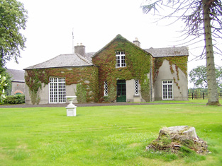
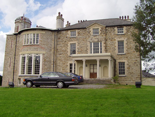
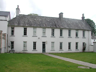
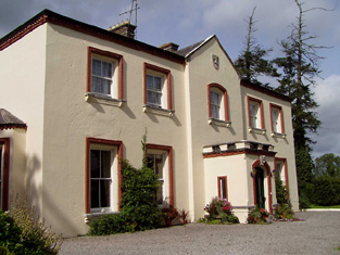
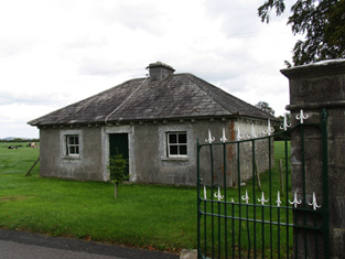
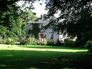
New Grove
Houses within 15km of this house
Displaying 72 houses.
Houses within 15km of New Grove
Displaying 72 houses.
| House name | Description | |
|---|---|---|
| Knockanacree Wood House | A house valued at £17+, occupied by Hawtrey Andrews and held from the Reverend Frederick F. Trench in the mid 19th century. Walford states that Hawtrey Andrews was the second son of Maunsell Andrews of Rathanny. This house is now demolished. | |
| Bellwood | The Reverend Archer was living at Greenwood in 1814. Bellwood is the name given to the house marked in this townland on the first edition Ordnance Survey map. Henry Lysaght was the occupier at the time of Griffith's Valuation holding the house valued at £11+ from Sir John C. Carden. This building is still a residence. |
|
| Oldtown | The home of the Bennett family in the 19th century, occupied by Theophilus Bennett in 1814 and by John Bennett in the early 1850s. The property was held from the Cardens and the buildings were valued at £19+ in the mid 19th century. This house was demolished by the early 20th century. | |
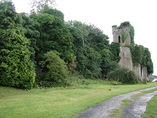
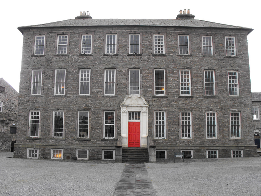
| Templemore Abbey/The Priory | In 1837 Lewis refers to the Castle at Templemore being the residence of the Carden family "up to about a century ago" when it was accidentially burnt by fire. He states that more recently the Carden family had lived at the Priory, a house marked on the first edition Ordnance Survey map and valued at £96+ at the time of Griffith's Valuation. This house was rebuilt in the 1860s and was burnt in the early 1920s. The stableyard is still extant. In 1894 Slater had referred to Templemore Abbey as the seat of Sir John C. Carden. |
|
| Woodville | The residence of the Webb family in the 19th century. The house was valued at £49+ in the early 1850s, occupied by Captain Daniel James Webb and held from Sir John C. Carden. Still a fine residence just south of Templemore. |
|
| Eastwood | Lewis records Thomas Bennett as the proprietor of Eastwood. James Mason held Eastwood House and 209 acres from Thomas Bennett at the time of Griffith's Valuation. The buildings were valued at £22+. Buildings are still located at this site. | |
| Green Hills | The home of a branch of the Minchin family in the 18th and for part of the 19th centuries. The house was occupied by the Reverend William Minchin in the first half of the 19th century. It was valued at £34.15 shillings at the time of Griffith's Valuation and held in fee. The sale rental of 1851 describes the house as large and commodious and in good repair. Bought by a brother of one of the Reverend Minchin's son in laws Montague Blackett. This house no longer exists. | |
| Barnane | Barnane, at the foot of the Devil's Bit mountain, was the seat of a branch of the Carden family. Occupied by John Carden in 1814 and by R. Carden in 1837. John Carden held the property in fee with 1,430 acres at the time of Griffith's Valuation. Andrew M. Carden was resident at Barnane in 1906 when the buildings were valued at £120. The house is now a ruin. |
|
| Derrylahan House | This house was the home of the Mason family in the 19th century, occupied by James Mason in 1814 and by William Mason in the early 1850s. The buildings were valued at £10 and held from Peter D. La Touche. William Mason of Derrylahan owned 228 acres in the 1870s. A house and farm are still extant at the site. | |
| Longford | The Ordnance Survey Name Books refer to Robert Lloyd as the proprietor of Longford House in the 1840s and it was occupied by him and held from Thomas Prince Lloyd at the time of Griffith's Valuation when the house was valued at £16. A mansion house in the townland of Longford valued at £34+ was occupied by James Lloyd in 1906. A building is still located at this site. | |
| Mountfrisco | Mount-fresco was occupied by Thomas Lloyd in 1814 and by Horatio Lloyd in 1837 and in the early 1850s. The house was then valued at £10 and held in fee. This house is no longer extant. | |
| Birchgrove | The home of the Birch family, occupied by George Birch in 1814. In 1837 Lewis writes that Birchgrove was the seat of J. Birch and that some additions were made to the house by the "late Mr Elsam". The 1835 map of Birchgrove includes a small pen and ink drawing of the house. Griffith's Valuation records George Birch as the occupier holding the house valued at £27+ and his distillery valued at £66 from the Earl of Portarlington. In 1910 Birch Grove was the home of Edward Robert Birch, eldest son of James Sayce Birch and his wife, Mary Warburton. This house on the outskirts of Roscrea is still a residence. |
|
| Corville | Corville was the residence of the Hon Francis A. Prittie in the first half of the 19th century. He was a brother of the 2nd Lord Dunalley. He represented county Tipperary in Parliament and died in 1853. Lewis describes the house as "a handsome structure in the Grecian style". In 1840 the Ordnance Survey Name Books refer to the townland of Corville as "large and beautiful, the principal parts nicely laid out with plantings". At the time of Griffith's Valuation it was valued at £58 and held from the Messrs Birch. The sale rental of 1858 includes a lithograph of the house. The house belonged to O'Byrne family in the later part of the 19th century and is recorded as the seat of Count John O'Byrne in 1894. Now functions as a nursing home. |
|
| Monaincha | Lewis describes Monaincha in 1837 as "an elegant villa in the Italianate style" the residence of G. Birch. Mrs G. Birch was living at Monaincha in the early 1850s whens the buildings were valued at £22.10 shillings. Occuppied by Harriet F. Miller in 1906. The house is still a fine residence close to Roscrea. |
|
| Racket Hall | Racket Hall was occupied by Patten Smith in 1814. Lewis writes that Messrs Birch and Co had a large brewery at Racket Hall and Mrs Mary Birch was the occupier of the house at the time of Griffith's Valuation. She held the property valued at £16+ from George Birch and Co. The brewery was valued at £18. The house is now incorporated in a hotel complex see http://www.rackethallhotel.com/welcome.html | |
| Loran Park | The seat of the Roe family in the 19th century, occupied by George Roe in 1837 and in the early 1850s, when the house was valued at £25.10 shillings and held from Henry Minchin. The residence of Ellen Robinson in the mid 1870s. A house and farm are still extant at the site. | |
| Whiteville | Leet records Mr Stephen Ryan as the resident of White-ville, Moneygall, in 1814. The Ordnance Survey Name Books refer to Whiteville as the residence of Robert White. Benjamin White was the occupier at the time of Griffith's Valuation. He held the property in fee and the buildings were valued at £13+. This house marked on the first edition Ordnance Survey map was replaced by a later house known as Knockanroger House and located slightly to the north of the original structure. A house is still extant at the site. | |
| Rockforest | Originally a Hutchinson property, incorporating the old castle of Knockballymaher, which passed to Edward Corker Minchin following his marriage in 1848 to Sarah Anne, only child by his first marriage of William Henry Hutchinson. Stephen Minchin was the occupier at the time of Griffitih's Valuation holding the property from Edward Minchin. The buildings were valued at £16. ''Burke's Irish Family Records'' states that Rockforest was sold in the Encumbered Estates' Court in 1852 and the Minchins emigrated to New Zealand. It appears to have been bought by William Gibson, father of Captain William Gibson who was residing at Rockforest, Roscrea in the 1870s. This house is now demolished but the outbuildings and stables still remain intact. |
|
| Timoney Park | This house was the seat of the Hutchinson family in the 19th century. Lewis refers to the great improvements made by J.D. Hutchinson at Timoney. By the mid 19th century the house was valued at £51 and was held in fee. It was occupied by Standish Grady J. Hutchinson in 1906. It is now a roofless ruin. |
|
| Dangansallagh | Lewis records J. Lewis as resident at Dangan Lodge in 1837 and Griffith's Valuation records James Middleton holding the lodge valued at £10+ and 266 acres in fee. It is now a ruin. | |
| Sheehills House | Occupied by William H. Minchin at the time of Griffith's Valuation and held with 874 acres from the Earl of Portarlington. The buildings were valued at £15.10 shillings. The Reverend John George Birch occupied buildings valued at £19+ and 880 acres of untenanted land at Thesheehys in 1906. A building is still located at this site. | |
| Dromard | The home of the Lidwill family, occupied by George Lidwill in 1814 and by Fred Lidwill in 1837 and in the early 1850s. The house was valued at £11 and held from George Goold. In the early 1940s the Irish Tourist Association surveyor described Dromard as a "very pretty building, set amidst well kept grounds and pleasure gardens". The owner was Colonel Robert Lidwell. Dromard House, Templemore, on 253 acres was advertised for sale in ''The Farmers Journal'' (6 Nov 2004) and sold for over 4 million euro in 2006 see http://www.independent.ie/national-news/yesterdays-auction-results-73225.html | |
| Ash Park | Ash Park or Park was the home of the Butler family in the 18th and 19th centuries. Occupied by James Butler in 1814 and 1837 and by Captain James Butler at the time of Griffith's Valuation. The buildings were valued at £35+ and held in fee. This house no longer exists. | |
| Skehanagh | George Lloyd was living in a house valued at £16 at Skehanagh North in the mid 19th century.The Ordnance Survey Name Books note "Skehana" as the residence of George Richard Lloyd in 1840. In the 1870s Horatio M. Lloyd of Skehana, Templemore owned 182 acres in county Tipperary. Catherine Lloyd was resident in 1906. This house burnt down and the present building on the same site dates from the early 20th century. |

|
| Killoskehane | This house was the seat of the Willington family. In 1837 Lewis wrote that Killoskehane Castle "includes part of the ancient castle in the modern mansion". The property was held by John Willington in fee at the time of Griffith's Valuation when the buildings were valued at £29+. Edward D. Martin was the occupier of Killoskehane in 1906 and William Costigan in the 1940s. The building is still extant and occupied. |

|
| Lisduff | The Smiths were resident at Lisduffe from the early 18th century when Jeremiah Lalor married the daughter of Samuel Smith of Lisduffe. From this couple descend the Lalors of Long Orchard. Samuel Smyth was the occupant of Lisduff in 1814 and William Smith in 1837. Griffith's Valuation records John Minchin as resident. The buildings were then valued at £33 and held from Admiral Darby. This house is still a residence. |
|
| Ashbury | Ashbury, a house valued at £12 in the mid 19th century, was the residence of Timothy Bridge. Members of the Bridge family held the townland from the Earl of Portarlington at this time. The Irish Times reported, in February 1869, that Frederick Bridge had sold lands in the barony of Ikerrin to Rev. Dean Wolseley for over £2000. In the 1870s Edward and Timothy Bridge both of Ashbury owned 191 and 143 acres respectively in county Tipperary. | |
| Glenalbert House | Glen Albert House was the home of Albert E. Maxwell in 1837. In 1840 the Ordnance Survey Name Books note the opinion that "this is an Irish name fabricated at a very recent period". It was also occupied by A.E.Maxwell at the time of Griffith's Valuation when the house was valued at £30 and held from Dawson H. Vaughan. The Harte Maxwells were resident at Glenalbert in the first two decades of the 20th century. This house is now completely demolished. | |
| Montevideo House | A house marked on the first edition Ordnance Survey map and occupied by Francis Smallman in the mid 19th century, when the buildings were valued at £20 and held from the Earl of Portarlington. The National Inventory of Architectural Heritage names this house Beechmount. |
|
| Mount Dudley | A house close to the town of Roscrea and marked on the first edition Ordnance Survey map. In the mid 19th century occupied by Samuel Dudley, valued at £17 and held with 29 acres from the Earl of Portarlington. The home of Thomas Ely in the 1870s. This house is extant and occupied. |
|
| Inane | In 1786 Wilson mentions Inane as the seat of Rev. Curtis. Robert Curtis was the proprietor of Inane, Roscrea, in 1814 and P. Jackson was resident in 1837. By the time of Griffith's Valuation Frederick A. Jackson was the occupier, holding the property in fee. The buildings were valued at £50. There appear to be two houses at Inane, a nine bay house dating from the early 18th century and a 19th century house very closeby. The Jacksons were still resident in the 1870s and the representatives of Henry V. Jackson held the property in 1906. It is still extant. |
|
| Lloydsborough | In 1786 Wilson mentions that Lloydsborough was the seat of Mr. Carden. This house was the seat of the Lloyd family in the 19th century. In 1814 Henry Lloyd was resident and in 1837 John Lloyd was the occupant. Griffith's Valuation records John as holder of the property in fee and the buildings were valued at £44+. Lloydsborough was still in the possession of a branch of the Lloyd family in the early 20th century. Still extant and occupied, Lloydsborough was offered for sale in 2014. |

|
| Castleleiny | A house occupied by John Lloyd and his wife Debby Ann in the early part of the 19th century. Henry Jesse Lloyd son of the Reverend George Lloyd of Castle Iny and his wife Anne Hely entered the King's Inns in 1840. By the mid 19th century William Healy was the occupant holding the house valued at £12+ from the Earl of Orkney. | |
| Honeymount | Honeymount was occupied by John Evans in 1814 and by Captain Lloyd in the early 1850s, when it was valued at £11.10 shillings and held from Leonard Williams. Robert Lloyd is recorded as the tenant in the sale notice of 1856. Honeymount, part of the estate of the Mahons of Co Clare, was advertised for sale in July 1871. A house is still extant at the site. In 2014 it was offered for sale. |

|
| Bantis | In 1814 Mr Kennedy is recorded as the proprietor of Bantis and Lewis mentions the extensive brewery of Edward Kennedy at Bantis in 1837. The Ordnance Survey Name Books record Bantis as "a neat dwelling house", the residence of Edward Kennedy. Buildings valued at £31+ and 526 acres at Bantis were held from the Honourable O.F.G. Toler by Edward, James, Denis, John and Patrick Kennedy and Henry Fitzgerald at the time of Griffith's Valuation. A house is still extant at the site. | |
| Camira | Occupied by the Reverend P. Bolton in 1837 and by William Jackson in the early 1850s, when the house valued at £11.14 shillings was held from Anne Crawford. In the possession of the Cole Bowen family in the later 19th century. This house no longer exists although a building is still located at the site. http://www.askaboutireland.ie/reading-room/history-heritage/big-houses-of-ireland/the-cole-bowen-estate/bowen-family-history/ | |
| Donnybrook | This house was the seat of a branch of the Poe family in the 18th and 19th centuries. William Poe was resident in 1814 and Lewis records him as the proprietor but the house was occupied by a tenant. The Ordnance Survey Name Books mention William Jackson as the occupier and describe the house as "large and commodious". At the time of Griffith's Valuation William Poe held the property in fee, the buildings were valued at £16.14 shillings. Donnybrook is still extant. |
|
| Wilton | This house located close to Donnybrook was vacant at the time of Griffith's Valuation and held by William Poe. It was valued at £10+. Earlier, in 1839, the Ordnance Survey Name books had noted it as the residence of John Poe but "out of repair at present". It no longer exists. | |
| Falleen | The home of the Hawkeshaw family in the 19th century, held from the Bowens of Bowens Court. Benjamin Hawkeshaw is recorded as the occupant in 1814 and in the early 1850s when the house was valued at £13.14 shillings. G. Riall was resident in 1837. The Ordnance Survey Name Books refer to Falleen as the seat of James Bennett in 1839. A house is still extant at the site. | |
| Knockane | Knockane was occupied by Mr William Cooke in 1814. In 1840 the Ordnance Survey Name Books describe it as " a commodious house the property of Mr. Hawkshaw". It was the residence of William Hodgens in the early 1850s, when the buildings were valued at £12.17 shillings and held from Robert Cole Bowen. A possibly later house is located at the site now. | |
| Pallas | The home of the Short family in the first half of the 19th century held from the Bowens of Bowens Court. John Short was resident in 1814 and 1837. The Ordnance Survey Name Books describe it as "a commodious dwelling with pretty demesne". It was occupied by Edmund Short at the time of Griffith's Valuation when the buildings were valued at £10. A farm is located at the site. | |
| Bessborough | In 1814 this house was occupied by John Mahon and in 1837 by T. Sadlier junior. The Ordnance Survey Name Books indicate that the proprietor was Mrs. Harding of Dublin and describe Bessborough as " a most beautiful house, occupied by Mr. Cushin, solicitor". By the time of Griffith's Valuation Dr John Armstrong was resident. He held the property from Mrs Harding and the buildings were valued at £20+. Jonathan Harding of Bessborough, Nenagh owned 163 acres in the 1870s. Slater refers to this house as the residence of David E. Young in 1894. It is still in use as a residence. |
|
| Woodville | Woodville was a home of a branch of the Minchin family from the mid 18th century. The Reverend James Poe was resident at Woodville, Nenagh, in 1814 and Lewis records Humphrey Minchin as the proprietor in 1837. The Ordnance Survey Name Books mention that it had "by far the most beautiful demesne in the parish". He is also recorded as the occupier in Griffith's Valuation when the house was valued at £20.14 shillings and held in fee. When advertised for sale in 1869 James J. Poe was given as the tenant under the Court of Chancery. The house was described as containing a basement story, three large sitting rooms and five principal bedrooms. In 1906 occupied by Alice M.M. Bunbury. George W. Bunbury of Woodville owned 516 acres in the 1870s. |
|
| Fairyhill | Fairyhill was the home of William Henry Cox in 1837. The Ordnance Survey Name Books describe it as "a large mansion house, the residence of Mr. Cocks [sic]" in 1841. It was occupied by Ellen Robinson in the early 1850s, when the house was valued at £19 and held from Lord Ashtown. Valued at £16 in 1906 and held by George W. Robinson. This house is still in use as a residence. |

|
| Clifton | Lewis records Clifton as the seat of Captain Sheppard. The Ordnance Survey Name Books refer to it as "a modern building, the residence of Capt. Sheppard" in 1841. Arthur Sheppard [?] was the occupier at the time of Griffith's Valuation. He held the property from Thomas Pyke and the buildings were valued at £14.10 shillings. The National Inventory of Architectural Heritage records the present house as dating from 1868. |
|
| Behamore | The Reverend Thomas Hawkshaw was resident here in 1814 and Benjamin Hawkshaw in 1837. The Ordnance Survey Name Books also note it as his residence, describing Behamore as "a commodious house". James Fleetwood was the occupier in the early 1850s holding the property from Lord Dunalley, it was valued at £13+. A building is still located at this site. | |
| Wingfield | A house located just inside the county Tipperary border with county Offaly. The property belonged to John Shortt in the mid 18th century. When he died in 1768 his widow Frances (nee Spunner) married Jonathan Doolan. Wingfield was occupied by Jonathan's son Thomas Doolan in 1814 and in 1837. The Ordnance Survey Name Books refer to it as the residence of [Paliner?] Thomas Doolan in 1840. By the time of Griffith's Valuation Henry Spunner was resident. He held the property from Jonathan Short and the buildings were valued at £20. Richard Thomas Croasdaile and his sister Margaret occupied the house in 1901. This house is now a ruin. |
|
| Northland | Northland was the residence of Sir A. Dancer in 1814 and of William Smith in 1837. By the time of Griffith's Valuation William Henry Head occupied this house valued at £10. He held the property from Lord Dunalley. The house was demolished by the early 20th century. | |
| Willow Lodge | James Fleetwood was resident at Willow Lodge in 1814 and in 1837. By the time of Griffith's Valuation the house appears to be only valued at £1 and occupied by David Tierney. Willow Lodge is marked on the first edition Ordnance Survey map. It is named Alma on the 25-inch map of the 1890s. There is still an extant house at the site. | |
| Deer Park | Lewis records Park House as the property of William Trench but the residence of De La Pere A. J. Robinson. The Reverend Frederick F. Trench was the occupier in the mid 19th century, holding the house valued at £23 from Lord Dunalley. This house still functions as a residence. |

|
| Cloghjordan House | This house was the home of the Reverend Edwin Palmer in 1814. By the time of Griffith's Valuation John Hodgins occupied the house and ran the nearby nursery gardens. The buildings were valued at £13+ and held from Lord Dunalley. This building which includes the remains of the old castle still functions as a country residence. |
|
| Tenessee | This house is labelled Tenessee House on both the First and 25-inch edition Ordnance Survey map. In 1841 the Ordnance Survey Name Books suggest that it was the property of Lord Dunally. In the mid 19th century it was occupied by Thomas R. Barnes and held from Joseph Falkiner. The buildings were valued at £14. 15 shillings. The house is still in use as a residence. |

|
| Coolnamunna | At the time of Griffith's Valuation Edward Kennedy held buildings valued at £34+ from Ellen Lloyd [widow of Henry Jesse Lloyd of Castle Iney?] in the townland of Coolnamunna. He had a distillery in Mullenkeagh valued at £47. Edward Kennedy of Coolnamoner Park owned 432 acres in county Tipperary in the 1870s. |
|
| Glenahilty | William Kennedy was occupying Glenahilty from at least 1837 when Lewis records him as resident althought the property belonged to J.C. Fitzgerald. The house was valued at £6.10 shillings at the time of Griffith's Valuation and was held with 189 acres of land and 210 acres of bog from Fitzgerald. | |
| Modreeny House | In 1786 Wilson refers to "Moderenny" as the seat of Sir Amyrald Dancer. The Ordnance Survey Name Books refer to the house as Eminisky House in 1841 but it is marked on the first edition map as Modreeny House and was the home of the Dancer family. It was replaced by a new house circa 1920s. The outbuildings, gates and gatelodge of the original house still remain. At the time of Griffith's Valuation Sir Thomas B. Dancer held this property in fee. The buildings were valued at £21. Hussey gives Modreeny House as the address of Sir Thomas Dancer in 1878. |
|
| Hilton | Hilton, located just to the south of Modreeny House, was the home of Thomas Dancer, later 6th Baronet, in 1837 and of the 6th Baronet's son, Thomas J. Dancer, in the mid 19th century. Thomas J. Dancer held the house valued at £15 from his father Sir Thomas B. Dancer, 6th Baronet. In 1841 the Ordnance Survey Name Books had noted the house as the residence of Thomas Stoney. A house is still located at this site. | |
| Elysium | This house is marked on the first edition Ordnance Survey map and was inhabited by Thomas Ely in 1837. Thomas Ely held the property in fee at the time of Griffith's Valuation when the house was valued at £23. The Elys were still resident in the 1870s. George Evans was occupying this house in 1906. There is still a house located at this site. | |
| Modreeny | Lewis records W. H. Head as the proprietor of Modreeny House in 1837. He was still resident at the time of Griffith's Valuation and held the house valued at £35 in fee. Burke's ''Landed Gentry of Ireland'' (1904) records William Henry Head's father as "of Modreeny House". In 1906 the representatives of George Whitfield were the occupiers and the house was valued at £36.10 shillings. George Whitfield of Modreeny owned 443 acres in the 1870s. In 1890 his daughter Kathleen married Sir Francis Osborne, Baronet. This house was bought by Donald Swan in 1965 and Charlie Swan, champion jockey, was born at Modreeny in 1968. |
|
| Aghsmear | This house is not marked on the first edition Ordnance Survey map. Griffith's Valuation records a house of £4.5 shillings valuation occupied by Dr Patrick Cleary and held from Joseph Griffith. Joseph Griffith lived at Aghsmear in the 1870s and he was still resident in 1906 when the mansion house was valued at £22+. |
|
| Killough (Templemore) | Cottage type house built 1880. In 1906 Richard J. Lloyd is recorded as the occupier of a mansion house valued at £27+ in the townland of Killough. |
|
| Derryvale | A Smith home, occupied by William Smith in 1837. The Ordnance Survey Name Books mention "Mr. White" in connection with Derryvale. John S. Smith was the occupier in the mid 19th century when the buildings were valued at £11.15 shillings and held from Richard Cathcart. Occupied by Sidney E. Smith in 1906. Derryvale is still extant. |
|
| Sorrellhill | James Bennett was resident at Sorrel-hill, Templemore in 1814. This house is marked on the first edition Ordnance Survey map but looks larger in size on later maps. At the time of Griffith's Valuation, valued at £16.10 and held by Dudley Byrne from Philip Gowan. This house is still extant. | |
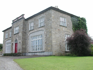
| Damer House | Located in the centre of Roscrea, this house was built by the Damer family in the early 18th century. Used as a barracks for much of the 19th century, it has also functioned as a school. Saved from demolition by the Old Roscrea Society and the Irish Georgian Society in the 1960s, it is now under the care of the Office of Public Works and the Roscrea Heritage Society. |
|
| Ballymackey House | Ballymackey House is described as "in ruins" at the time of the first Ordnance Survey in the 1830s. An earlier tower house is also shown, described as "Ballymackey Castle (in ruins)". Wilson, writing in 1786, refers to "Ballymakey" as the seat of Mr. O'Meara. The Ordnance Survey Name Books describe Ballymackey House as "an old house adjoining the south side of Ballymackey old castle.....now in a state of total ruin". By the time of Griffith's Valuation, this townland was part of the Cole-Bowan estate. Most of the site is now occupied by extensive farm sheds though ruins of the old castle are still visible. | |
| Elm Hill House | The Ordnance Survey Name Books record William Middleton as the occupier of Elm Hill House in 1839 and mention the surroundings as "a very pretty demesne situated in a beautiful locality". At the time of Griffith's Valuation, William Middleton was leasing this property from the Poe estate when the house was valued at almost £8. The original house is no longer extant and a modern house has been constructed at the site. | |
| River Lawn | In 1839, he Ordnance Survey Name Books describe River Lawn house as "a commodious house, the property of William Poe, in the occupation of E. Radford esq". At the time of Griffith's Valuation, when it was valued at almost £10 it was leased by Augustus H. Going from William Poe. It is still extant and occupied. |
|
| Mill Grove House | In 1841, the Ordnance Survey Name Books describe Mill Grove House as " a good house with demesne and plantations, the residence of Mr. Kennedy". At the time of Griffith's Valuation, Edward Kennedy was leasing a substantial milling complex and a house at this location from the Stoney estate. The buildings had a value of £46+. It is labelled Millgrove House on the 25-inch map of the 1890s but is no longer extant. | |
| Ballykelly House | In 1840 the Ordnance Survey Name Books describe Ballykelly House as "a gentleman's seat, so called". At the time of Griffith's Valuation the house and demesne were leased by James Kennedy from Edward Minchin when the buildings were value at £10. There is still an extant house at Ballykelly. | |
| Verdanthill House | In 1840 the Ordnance Survey Name Books record Verdant Hill House as the residence of George Wilson. By the time of Griffith's Valuation it was occupied by George Fitzmaurice, leasing from Rev. David Brownrigg when it was valued at £19. It is still extant. |
|
| Millpark Mill Cottage | In 1840 the Ordnance Survey Name Books refer to Millpark House as the residence of Mr. Lyster. At the time of Griffith's Valuation Hamilton Lyster was leasing a property in the townland of Millpark from Robert Acres. It included a house and mill and was valued at £53. Some ruins of the mils still remain. A building is still extant on the site of Millpark Cottage. | |
| Millpark House | At the time of Griffith's Valuation, Adam Acres is recorded as the occupier of Millpark House, which he was leasing from the Vaughan estate. The house was valued at £18. It is still extant. | |
| Butler's Lodge | In 1840 the Ordnance Survey Name Books refer to Butler's Lodge as "a gentleman's seat" in the townland of the same name. The house is labelled as Butler's Lodge on the 1st edition Ordnance Survey map but is not labelled on the 25-inch edition of the 1890s. At the time of Griffith's Valuation it was valued at over £5 and part of the estate of Edward Cambie. A modern house occupies the site now. |