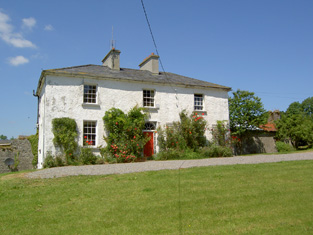
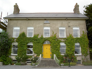
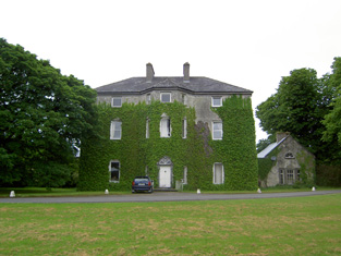
Gurteen
Houses within 15km of this house
Displaying 72 houses.
Houses within 15km of Gurteen
Displaying 72 houses.
| House name | Description | |
|---|---|---|
| Lakefield (Middlethird) | Gambonstown was occupied by B.B. Bradshaw in 1814. In 1786 Wilson had referred to it as the seat of Mr. Hackett. The National Inventory of Architectural Heritage records the building of Lakefield house in 1831 by William Pennefather, replacing the former Hackett home of Gambonstown. and the Ordnance Survey Name Books record it as his residence in 1840. At the time of Griffith's Valuation William Pennefather held the house valued at £48.14 shillings and 413 acres from Mrs Hackett and others. Sold by the Pennefathers to the O'Briens in 1907 and sold again to the Goodbodys in 1955. Lakefield is still extant. |
|
| Ballycurkeen | The home of James Manderville in the mid 19th century, held from James F. O'Ryan and valued at £19+. Ballycurkeen was still a Mandeville home in the early 1940s when Frank Mandeville was recorded as resident. The Irish Tourist Association surveyor also writes that Ballycurkeen was the residence of John O'Mahony, a Fenian leader in 1848. This house is still a family home. |

|
| Anner Castle | Marked on the first Ordnance Survey map as Ballina House, this residence of the Reverend Nicholas Manderville was valued at £46+ and held by him in fee in the early 1850s. Bence Jones writes that Anner Castle was built in the 1860s "incorporating the old square castle of the Manderville family which had up till then been known as Ballinahy". It was destroyed by fire in 1926 and only the front portion was rebuilt. The Mandervilles were still resident in the 20th century. This property was sold in 2013. |
|
| Ballydine | The Mandevilles were situated at Ballydine from the 14th century. Ballydine Castle was sold to the Earl of Clonmel in 1781 and members of the Power family lived there in the first half of the 19th century, William Power in 1814 and James Power in the early 1850s. The Powers and the Mandevilles were related. A lithograph of the house is included in the Power sale rental of 4 November 1853. ''Burke's Irish Family Records'' records Frank Hackett Mandeville (1841-1905) as the last family member to live at Ballydine. He was Member of Parliament for mid Tipperary 1892-1900 and died at Ballydine Castle in 1905. Mary Lyons records the Landy family as resident from 1855-1901. | |
| Redmondstown | In 1814 Redmondstown was the residence of J. Parson Ducket and in 1837 of a member of the Quinn family. In the early 1850s R.G. Fitzgerald was the occupier, holding the house valued at £16.15 shillings from the Earl of Glengall. This house is still extant and is located in a wooded area. Thomas Albert Quin of Redmondstown owned 612 acres in the 1870s. | |
| Ballyvaughan | The Bushell family were located at Ballyvaughan from the 18th century. The will of Edward Bushell of Ballyvaughan dated 30 July 1778 names his six sons. At the time of Griffith's Valuation Samuel Bushell held buildings valued at almost £13 from John Lindsey. http://www.igp-web.com/IGPArchives/ire/tipperary/wills/bushell01.txt | |
| Kilheffernan/Cottage | Thomas Ryan was the proprietor of Cottage, Clonmel, in 1814 and Lewis records T. Ryan of Cottage, parish of Killaloan. At the time of Griffith's Valuation Patrick Fennelly held the house valued at £10.13 shillings from Thomas Ryan. Altered over the years this house is still in use as a residence. |
|
| Kilmurry Lodge | A house valued at £16.13 shillings was occupied by the Reverend Richard Morrissey in the townland of Ballynamona at the time of Griffith's Valuation. It was held from William P. Barker. Kilmurry Lodge is marked on the first Ordnance Survey map and is described in the Ordnance Survey Name Books as "a lodge, handsomely situated, with a garden, orchard and fir plantation". This house is still in use as a residence. |

|
| Lindville | A house named Lindville is marked on the first Ordnance Survey map in this townland close to the bank of the River Suir. At the time of Griffith's Valuation it was valued at £16+ and occupied by Thomas Lindsey who held it from William Butler. No building is now extant at this site. | |
| Newtown Anner | The seat of the Osborne family, held by R.B. Osborne MP in fee in the mid 19th century when the buildings were valued at £56+. Inherited by 12th Duke of St Albans, grandson of R.B. Osborne. Occupied by the Duchess of St Albans in 1906 and still in this family's possession in the early 1940s. The Irish Tourist Association survey states that the Osbornes bought the property from Clonmel Corporation in 1774. The National Inventory of Architectural Heritage dates this house 1829. It continues to be in use as a residence. |
|
| Cregg | The home of a branch of the Lalor family in the 19th century. Thomas E. Lalor is recorded for Creg in 1814 and Lewis writes in 1837 of his handsome residence erected "about ten years since". Cregg was occupied by his son Thomas in the early 1850s. Thomas held the property from the Marquess of Ormonde and the buildings were valued at almost £40. Passed to the Sadlier family of Castleblake, county Tipperary at the end of the 19th century. In 1906 it was valued at £41 and occupied by Annie Sadlier. This house is still a fine residence. |
|
| Ballyknockane | Marked on the first Ordnance Survey map as Ballyknockane Cottage, valued at £21 and occupied by Walter Asper at the time of Griffith's Valuation. He held the property from the Marquess of Ormonde. In 1894 Slater noted it as part of the latter estate. This building no longer exists. | |
| Ballyboe | A house valued at £17+ in the mid 19th century when it was occupied by James O'Donnell and held from Lord Lismore. This house is still a family residence. |

|
| Ballynagrana | Taylor and Skinner's map indicates that this is the location of the house originally known as Wilmar, which was occupied by Nicholson Esq in the 1770s. Wilmar Mill is marked closeby in the townland of Ballyrichard on the first edition Ordnance Survey map. The Ordnance Survey Letters refer to the property as Wilmer House in 1840. Lorenzo Hickie Jephson lived at Wilmar for some time in the early 19th century. Francis Mandeville was resident in 1814. Denis Kennedy occupied a house in Ballynagrana, held from Denis Hayden and valued at £13.14 shillings at the time of Griffith's Valuation. Ellen Hayden of Ballynagrana owned 255 acres in county Tipperary in the 1870s. This house is no longer extant. | |
| Harley Park | The Poe residence at this location in the 18th century was known as Rosenaharly as mentioned by Wilson in 1786. The seat of the Poe family, occupied by James Poe in 1814 and by J.P. Poe in 1837. James Purefoy Poe was still resident in the mid 19th century, holding the property in fee. The buildings were valued at £41.10 shillings. The Poes were still resident in the early 20th century and this house is still a residence. |
|
| Ballyphilip | The seat of the Going family in the 18th and 19th centuries, W. and A. Going were resident in 1814 and Ambrose Going held the property in fee at the time of Griffith's Valuation. The buildings were valued at £30.15 shillings. This house was held by the representatives of B.F. Going in 1906. Buildings are still extant at the site. | |
| Ballinunty House | William Going occupied this house and held it in fee in the mid 19th century when it was valued at £24.10 shillings. In 1894 Slater notes it as the seat of Miss A.J. Going. This house no longer exists. | |
| Lisnamrock Castle | The Langleys were resident here from the 18th century. Wilson, writing in 1786, refers to Lisnarock as the seat of Mr Langley. Henry Langley was the occupier in the mid 19th century, holding the property in fee. The buildings were valued at £11.10 shillings. Held by George Langley in 1906. Buildings still exist at this location. | |
| Lickfinn | Fergus Langley occupied Lickfinn in 1814 and John Langley held the house valued at £12 and 273 acres in fee at the time of Griffith's Valuation. This house was later known as Knockanure. In 1906 held by the representatives of John Langley. | |
| Garrangibbon | This house known as South Lodge was occupied by J.B. Elliott in 1814. The Ordnance Survey Name Books describe it as "handsomely situated....with garden plantation and planted ornamental grounds" in 1840. It was occupied by Richard C. Jackson who held the house valued at £14 from the representatives of Mrs R. Hartford in the mid 19th century. Some alterations to the house have taken place in more recent times and it still functions as a country residence. |

|
| Glenview | Glenview was occupied by the Reverend Edmund Prendergast in the early 1850s. He held the house valued at £18.15 shillings from Matthew Prendergast. In the early 20th century the house was altered and extended by a religious order who set up a school. |
|
| Wilford | Wilford was the residence Butler Esq in the 1770s and 1780s and of Mr Richard Blackmore in 1814. In the early 1850s it was occupied by John Blackmore, who held the property valued at £11+ from William P. Barker with 128 acres. The house is labelled Wilford House on the 1st edition Ordnance Survey map but as Shangarry House on the 25-inch edition of the 1890s. It is now a ruin. | |
| Willmount | Occupied in 1814 by Robert Lane and by Hampden Lane in the early 1850s, when the house was valued at £17 and held from William P. Barker. This house is still an occupied residence. |
|
| Kilburry | The home of Jeremiah Meagher in 1814 and of Robert Maher in the mid 19th century. He held the house valued at £16.15 shillings from William Beasley. Buildings are still located at this site. | |
| Knockanglass | This house was the home of James Riall in the early 1850, who held the property from K.Pennefather. The buildings were valued at £18.15 shillings. The National Inventory of Architectural Heritage states that this house was associated with the Langley family and was sold to the O'Dwyers in 1912. It was occupied by Adelaide Langley in 1906. It still functions as a residence. |
|
| Moglass House | Moglass valued at £11 was held by John Riall from George Riall at the time of Griffith's Valuation. It is described as "in ruins" on the 25-inch Ordnance Survey map of the 1890s. | |
| Roan | Dennis Duan was resident here in 1814 and Robert Purcell in 1814. He held the property valued at £18.15 shillings from Matthew Jacob. This house had later associations with the Bianconi family and is still a family home. |
|
| Ballylanigan (Cramer) | [Thomas Pennefather is recorded as resident at Ballylanigan (Pennefather?) in 1814]. Lewis refers to the Cramer family of Ballylanigan. At the time of Griffith's Valuation Ballylanigan (Cramer) was occupied by Thomas Sexton and held from Mrs Catherine Reeves. The buildings were valued at £17+. This house still exists. | |
| Hilton | This house is not marked on the first Ordnance Survey map. The National Inventory of Architectural Heritage dates the house circa 1850. At the time of Griffith's Valuation the representatives of J. Stephens held most of this townland from the Pennefathers. The home of the Grant family from at least the 1870s. Slater refers to it as the seat of Colonel G. Fox Grant in 1894. Valued at £22+ in 1906 and occupied by Joseph B. Grant. It is still extant. in 2015 it was offered for sale. |

|
| Ballywalter | Occupied in the early 1850s by John Doherty, valued at £12 and held from the [Reverend] John Burdett, uncle of Arthur Burdett. | |
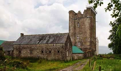
| Killaghy | This is an old tower house which has been altered and remodelled. In the 1770s and 1780s it was the home of Greene Despard Esq. In 1837 Lewis refers to W. Despard as the proprietor of Killaghy ‘which was the residence of Baron Tobin, and was taken by Cromwell, who gave it to a Col. Green, from whom it has descended to its present proprietor’. Griffith's Valuation also records William Despard as the occupier. He held the house valued at £23 from Sir Riggs Falkiner. Bence Jones writes that Killaghy passed from the Despards to the Wrights by inheritance. Hubert H Fox of Killaghy Castle owned 321 acres in county Tipperary in the 1870s. In 1894 Slater refers to it as the seat of Miss M.A. Walpole. Killaghy has had a number of owners in the 20th century and continues to function as a country residence. For sale in 2010 see http://www.michaelhdaniels.com. |
|
| Mohober | Mohober was occupied by Scott Esq in the 1770s and 1780s. It was the home of the Cormick family in the 19th century. Richard Cormick was resident in the early 1850s holding the property from the Earl of Clonmel. The buildings were valued at £14.15 shillings. In the 1870s Daniel Cormack of Mohober owned 189 acres in county Tipperary. The sale rental of the interest of James P. Welply in the house and demesne of Mohober dated July 1868 records that the property was conveyed to Daniel Welply by the Encumbered Estates Commissioners in May 1856. The original lease dated 1766 was from William Cane to Mark Scott. The Cormac interest in this property was advertised for sale in June 1876. Buildings are still extant at this site. | |
| Oakfield | A house occupied by Purefoy Poe in 1814 and by the Reverend Daniel Corcoran in the early 1850s, when it was held from the representatives of R. Constable junior and valued at £15.10 shillings. The Ordnance Survey Name Books mention that there was a garden, fir plantation and planted ornamental ground attached to Oakfield House. Renovated in the 1930s it is still extant and inhabited. |
|
| Clonacody | The residence of John Hunt in 1814 but the Kelletts were resident by 1837. The Ordnance Survey Name Books refer to Clonacody as the seat of John D. Kellett. James Sadlier was the occupier in 1850 holding the house valued at £28+ from John Kellett. The sale rental of 1856 records James Sadlier as tenant under the Court of Chancery in a case Massey v Kellett. The Kellett family continued to live at Clonacody until the mid 20th century and the house is still extant. |
|
| Churchtown House (Dysert) | Leased from the Disney estate by James Connolly at the time of Griffith's Valuation, when it was valued at £25. In 1837 Lewis notes Churchtown as " the pleasant residence of John Power". In 1777, Charles Smith refers to it as the seat of Eccles Disney. The house is still extant. It was partially renovated in the early 21st century and in 2010 was offered for sale. |
|
| Glen Lower (Dysert) | Leased by Patrick Hurley from John Congreve's estate at the time of Griffith's Valuation, when the buildings were valued at £11 10s. This appears to be the property known as Glen Castle House taking its name from castle ruins nearby. A house is still extant at the site. | |
| Glen Lodge (Glen Poer) | Labelled on the first edition Ordnance Survey Map as Glen Lodge and on the later 25-inch map as Glen Poer. Held by James Gallway from James Power at the time of Griffith's Valuation, when the buildings were valued at £19. In 1876 it is given as the address of Capt. Walter Mansfield. The 1943 ITA survey notes it as the residence of Mrs. Monsell [?]. Now in the possession of the Rosminian Order as a retreat house and known as Glencomeragh House. |
|
| Cloneen House | The home of the Meagher family, occupied by William Meagher in 1814 and by Henry C. Meagher in 1850. The property was held from the Earl of Clare and was valued at £18. This house is still occupied. |
|
| Lismortagh | Matthew N. Sankey was residing at Lismortagh in 1814 and John Millett in 1850. Millet held the property from the representatives of William Burgess and the buildings were valued at £17.15 shillings. This 18th century house is still a fine residence. |
|
| Mortlestown Castle | Captain James G. Jacob was the occupant of Mortlestown Castle in 1814. By the time of Griffith's Valuation Thomas P. Lloyd was resident holding the property from Robert Jacob. The house was valued at £29. Buildings are still located at this site. | |
| Bannixtown | A Clutterbuck home from at least the 1770s, Richard Clutterbuck was resident at Bannixtown in 1814. On the first Ordnance Survey map circa 1838 Bannixtown house is recorded as "in ruins". In 1840, though, the Ordnance Survey Name Books mention Bannixtown as a large farmhouse. The 25-inch map shows a building labelled "Bannixtown House" at the same site. A house valued at £19 was occupied by John Shea at Bannixtown in the early 1850s and held from the representatives of Thomas Clutterbuck. John Shea of Bannixtown owned 254 acres in the 1870s. | |
| Grove | A mid 18th century house which was altered in the 1830s. Grove was the seat of the Barton family, mentioned by Wilson as the seat of William Barton in 1786. It was occupied in 1814 by Thomas Barton and by William Barton in 1837. The Ordnance Survey Name Books describe it as "a very large dwelling house with extensive offices" in 1840. At the time of Griffith's Valuation, William Barton held Grove in fee and it was valued at £69. Grove remained in the possession of the Barton family until the mid 20th century when it passed to the Ponsonby family. This house is still extant and occupied. |
|
| Kyle | A house occupied by Matthew R. Millett at the time of Griffith's Valuation, valued at £10 and held from Colonel W. Palliser. | |
| Ballyrichard | The Ordnance Survey Name Books describe Ballyrichard as "a good farmer's hosue with offices and garden" in 1840. The house, valued at £12.18 shillings, was occupied by Matthew Hughes and held from Colonel W. Palliser at the time of Griffith's Valuation. Richard H. Hughes of Ballyrichard owned 597 acres in the 1870s. A substantial farm is still extant at the site. | |
| Langley Lodge | In 1840 the Ordnance Survey Name Books refer to Langley Lodge as "a good house with offices and garden". This house was occupied by Mrs Mary Langley in the early 1850s. She held it from Henry Langley and the buildings were valued at £19.19 shillings. By the time of the sale in December 1853 John Kane was resident. A building is still extant at this site. | |
| Hamilton Abbey | Hamilton Abbey is described in the sale rental of 4 June 1850 as "old fashioned" but "a most romantic and elegant residence". It contained a "fine cellarage, servants apartments and offices, large sized hall, breakfast parlour, dining rooom and drawing room, ten bed chambers, dairy, pantries, etc." and was in the possession of W.H. Latham. It was valued in Griffith's Valuation at £15.3 shillings. This property appears to have originally belonged to Hamilton Lowe. The ''Limerick General Advertiser'' of 16 May 1820 records the giving of the nearby Augustinian Abbey at Fethard to the Reverend Thomas Condon, Prior, by Mrs Hamilton Lowe and W. Latham. |

|
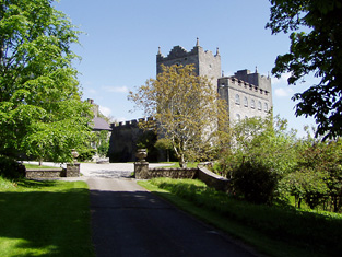
| Kiltinan | Kiltinane Castle was the seat of the Cooke family in the 18th and 19th centuries. Lewis describes the castle as the seat of R. Cooke, it "consists of an ancient circular tower .... and a residence erected on the old site by the late E. Cooke". In the mid 19th century the buildings were valued at £38+ and held by Robert Cooke in fee. Noted by Slater in 1894 as the seat of Robert Cooke. Sold by the Cookes in the 1920s to Mrs le Terrier, Kiltinan Castle now belongs to Andrew Lloyd Webber. |
|
| Peppardstown | The home of members of the Henderson family in 1814 and in 1850 when Samuel Henderson held a house valued at £10.14 shillings from Matthew Jacob at Peppardstown. In the mid 1870s Jerome James Guiry was living at Peppardstown, Fethard and the Guiry family were still resident in the early 21st century. The National Inventory of Architectural Heritage dates the present Peppardstown house from circa 1870. Beatrice P. Saunders was occupying the mansion house at Peppardstown in 1906. |
|
| Annesgift | This house was the home of the Glenstanes. In 1814 Anne Glenstanes daughter of John Jacob Glenstanes married Wray Palliser and the house passed into Palliser ownership. Annesgift was occupied by George Ponsonby in 1814, by Major Gough in 1837 and by Colonel W. Palliser and George Ponsonby at the time of Griffith's Valuation. They held the property in fee and the buildings were valued at £32+. This house was occupied by the Hughes family in the first half of the 20th century and is now converted into apartments. |
|
| Coolmore | The seat of the Sankey family in the 18th and 19th centuries, Coolmore was recorded by Wilson as the seat of Mr. Sankey in 1786. It was occupied by John Butler in 1814, by Matthew Villiers Sankey in 1837 and by Jacob Sankey in 1850. He held the property in fee and the buildings were valued at £37.15 shillings. In the second half of the 20th century Coolmore became a world famous stud for the breeding of race horses. The stud was set up in the late 1960s by Tim Vigors and continued by Vincent O'Brien, Robert Sangster and John Magnier. |
|
| Derryluskan | The Pallisers were resident at Derryluskan from at least the mid 18th century. John Palliser was the proprietor in 1814 and Mrs Palliser in 1837. Their son Colonel Wray Palliser was the occupant at the time of Griffith's Valuation. He held the property from Colonel Gore and the buildings were valued at £45.17 shillings and held with a demesne of 682 acres. The Pallisers were still residing at Derryluskan in the 1870s. The house has been greatly reduced in size but still functions as a residence. |
|
| Rathcool | Blake Esq was resident at Racool in the 1770s. In 1840 the Ordnance Survey Name Books describe Rathcool as "a castle apparently inhabited. There is another dwelling house attached with a garden". In the mid 19th century Rathcool Castle was occupied by Charles Blackmore and held from the representatives of L. Clutterbuck. The buildings were valued at £16.13 shillings. Charles Blackmore was still residing at Rathcool in the 1870s when he is recorded as the owner of one acre in county Tipperary. Rathcool is still in use as a house. |
|
| Rocklow | Taylor and Skinner records Rocklowe as the residence of Lowe Esq in the 1770s. Rocklow was the home of Benjamin Frend and his wife, Eliza Gough, in the first half of the 19th century. Benjamin was resident there from at least 1814 to the 1850s. Griffith's Valuation records that it was held from Hugh Barton and was valued at £37+ in the early 1850s. This house later belonged to the Massys and is still in use as a residence. In 2022 it was offered for sale. |
|
| St Johnstown | St Johnstown originally belonged to Matthew Jacob, whose only daughter and heir married Richard Pennefather of New Park in 1782. Wilson refers to it as the seat of Mr. Jacob in 1786 but their second son Matthew J. Pennefather was resident at St Johnstown in 1814. In 1837 Lewis records St Johnstown Castle as "consisting of a high square tower in good preservation, [it] is the property of James Millet Esq who has a modern house in its immediate vicinity". The buildings were valued at £31+ in the early 1850s, James Millet was still the occupier holding the property from Stephen C. Moore. | |
| Ballydavid | In the mid 19th century Patrick Murphy held a house valued at £10 from Thomas Power in the townland of Ballydavid. | |
| Clonbrogan | An early 18th century house built by Solomon Watson, the residence of M. Watson in 1814. By the time of Griffith's Valuation John Murphy was the occupier holding the house from Jeremiah Scully. It was valued at £5.14 shillings. This house is still a residence. |
|
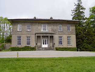
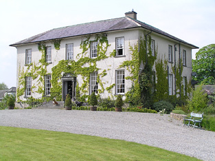
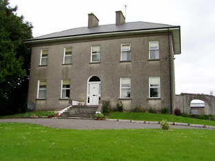
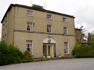
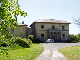
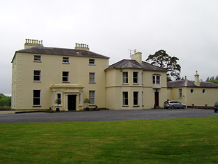
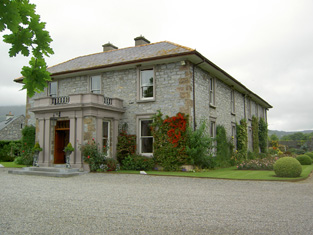
| Gurteen Le Poer/Gurteen House | Held in fee by John Power in 1850 when it was valued at over £96. In 1837 Lewis noted Gurteen as the seat of E. Power. Count Edmond de la Poer was the owner in 1894 and 1906 when the house was valued at £87. By the later nineteenth century it had come to be called Gurteen Le Poer, the name by which it is still known. |
|
| Landscape House | John Congreve held Landscape in fee in 1850 when it was valued at almost £20. Lewis also refers to it as a seat of the Congreve family in 1837. However, by 1906 Congreve's buildings at Landscape were only valued at £2. Landscape House is still extant and occupied. |
|
| Ballyglasheen | This house is not marked on the first edition Ordnance Survey map. The Inventory of Irish Architecture dates this house circa 1870. It was occupied in the 1870s by John Barnes. It is still extant and well maintained. |
|
| Hilton | A house built after the publication of the 1st Ordnance Survey map. The home of the Grant family from at least the 1870s. Slater refers to it as the seat of Colonel G. Fox Grant in 1894. Valued at £22+ in 1906 and occupied by Joseph B. Grant. It is still extant. In 2015 it was offered for sale. |
|
| Springhill | Occupied by Dr Samuel Hemphill and held by Samuel Hemphill Esq in fee at the time of Griffith's Valuation when the house was valued at £5.15 shillings. |
|
| Milltown House | In the mid 19th century Henry Briscoe was occupying a house valued at £10.19 shillings and held from Captain Richard Long. This house is still extant. | |
| Cloonyhea | A house valued at £11+ was occupied by Thomas Mansfield at Cloonyhea in the mid 19th century. It was held from John Bradshaw. A small house is marked on the first edition Ordnance Survey map at this location. It had increased considerably in size on later maps, still extant. | |
| Knockkelly | In the mid 19th century Richard Crane held a house valued at £12+ from William Barton in the townland of Knockkelly. This appears to be the house marked as Knockkelly house on the first edition Ordnance Survey map. | |
| Redcity | In the mid 19th century William Harney held a house valued at £11+ from Sir John Power in the townland of Redcity. Buildings are still located at this site. | |
| Ballyneill | Patrick O'Donnell held buildings valued at £13 from Rodolphus Scully at Ballyneill in the mid 19th century. This may be the present house however it looks as if it might date from later in the 19th century. It is situated close to the remains of Ballyneill Castle. |

|
| Cloran | A house valued at £10. 11 shillings at the time of Griffith's Valuation, occupied by Miss Mary Kelly and held from the Earl of Clare with 224 acres. A building is still located at this site. | |
| Ballinard Castle | In 1894 Slater refers to Ballinard Castle as the residence of William Tennant. At the time of Griffith's Valuation, John Lindsay owned land in the townland of Friarsgrange, parish of Coolmundry, in which Ballinard Castle is situated. It appears that, in the nineteenth century, a house was built adjoining the original tower house as, in 1840, the Ordnance Survey Name Books refer to Ballinard Castle, a gentleman's seat in the townland of Friarsgrange. Information in the Woodstock Museum, Ontario, Canada, indicates that the building was owned by the Lindsay family until 1926. The building is still extant. |
|
| Coolquill Castle | In 1786 Wilson refers to Coolquill as the seat of Mr. Gahan. The property is labelled "Coolquill Castle" on the 1st edition Ordnance Survey map and indicates that it was built on to a tower house. Coolquill was held in fee by Colonel Palliser in the mid 19th century. He was married to Anne Glenstanes. The castle was valued at £5. The castle ruin and other buildings are still extant at the site. | |
| Brookhill House | In 1786 Wilson refers to Brookhill as the seat of Mr. Lowe. The 1st edition Ordnance Survey map shows Brookhill house, "in ruins", in Farranshea townland, parish of Peppardstown. An old manor house, also in ruins, is shown as well. The Ordnance Survey Name Books, in 1840, describe the site as "two large houses, one having its eastern end and the other, its eastern side, joining the ruins of the Old Manor House". At the time of Griffiths' Valuation, the townland was in the possession of the Hackett estate and the houses are described as "in ruins". The ruins are not shown on the later 25-inch map of the 1890s. | |
| Knockbrack (Fethard) | In 1786 Wilson mentions Knockbrack as the seat of Mr.Letham. The house at Knockbrack, close to the village of Fethard, is described as "in ruins" on the 1st edition Ordnance Survey map. By the time of Griffith's Valuation, the townland was held in fee by William Barton, when the buildings were valued at almost £3. Farm buildings occupy the site of the old house now. | |
| Venter Fair | The Ordnance Survey Name Books refer to this house in the townland of Clashduff, parish of Ballingarry as "Venture Fair" and note the existence there of coal mines of the same name. At the time of Griffith's Valuation, it was leased by Mrs. Mary O'Sullivan from the Langley estate and valued at almost £10. A house is still extant at the site. |