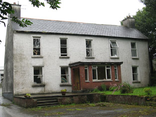
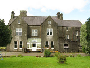
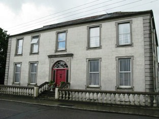
The Manor House (Dunmanway)
Houses within 15km of this house
Displaying 51 houses.
Houses within 15km of The Manor House (Dunmanway)
Displaying 51 houses.
| House name | Description | |
|---|---|---|
| Warrensbrook | Richard Donovan was leasing this property to Daniel Donovan at the time of Griffith's Valuation, when it was valued at £14. There is still a house at this site, part of a large farm complex. |
|
| Curraghalicky | Edward Powell was leasing this property to Edward Ellis at the time of Griffith's Valuation, when it was valued at £7 10s. The site is now occupied by substantial modern farm buildings. | |
| Baurnahulla House/The Cottage | George Robinson was leasing this property from the representatives of Thomas Deasy at the time of Griffith's Valuation, when it was valued at £12 15s. The adjacent mills were valued at £14. A house labelled The Cottage is shown adjacent to the site of Baurnahulla House on the 25-inch Ordnance Survey map of the 1890s. A house still exists at this site. Local sources suggest this was a house lived in by a Fr. Ryan in the 1830s. | |
| Dromdaleague House | At the time of Griffith's Valuation, Rev. Thomas Tuckey was leasing this property from George Bird, when it was valued at £12 5s. Lewis records it as the seat of Rev. T. Tuckey, rector, in 1837. | |
| The Cottage | A house built after the first Ordnance Survey. Thomas Gillman was leasing this property from George Wiseman at the time of Griffith's Valuation, when it was valued at £11 5s, It is still extant and known as Grove House. |
|
| Rock Castle Mill | John and James Gillman were leasing this property to John Hazel at the time of Griffith's Valuation, when it was valued at £8 and the mill at £52. In 1837 Lewis had noted it as the property of Mr. Heazle. It does not appear on the later 25" Ordnance Survey Map, suggesting perhaps, that it had ceased operations by the end of the nineteenth century. | |
| Lakemount House | Samuel Millner was leasing this property to Benjamin Millner at the time of Griffith's Valuation, when it was valued at £ 6 10s. In 1814 Leet notes Lakemount as the seat of George Beamish. There is still a house at this site. |

|
| Kilcaskan Castle | At the time of Griffith's Valuation, William O'Neill Daunt held this property in fee when it was valued at £32. In 1837 Lewis notes that it was held by Daunt and describes it as " a handsome castellated mansion". Both Taylor and Skinner and Wilson refer to it as a seat of the Daunt family in the 1780s. In 1894 Slater referred to it as the seat of Achilles Daunt. In 1906 it was also owned by Achilles Daunt and valued at £12 10s. The Irish Tourist Association Survey of 1944 referred to it as the residence of Miss M.O'Neill-Daunt. It is still extant. |
|
| Knockaneady | John Beamish was leasing this property to John Schofield at the time of Griffith's Valuation, when it was valued at £6. It does not appear on the later 25-inch Ordnance Survey map of the 1890s. | |
| Ballymoney Glebe House | At the time of Griffith's Valuation, Reverend Robert Meade was leasing this property from the Trinity College estates when it was valued at £23. A slightly different building is labelled "Rectory" on the 25-inch Ordnance Survey map of the 1890s. It is still extent and in use. |
|
| Phale Court | At the time of Griffith's Valuation, Standish Smithwick was leasing this property from William Stanley, when it was valued at almost £8. It is recorded as Phale House on the 1st edition OS Map and as Phale Court on the later 25 inch Map. In 1837, Lewis refers to Phale House as the seat of E.H. Good. In 1914 it was occupied by the Hosford family. In 1786 Wilson refers to it as the seat of John Wade. It is also associated with the Deasy family. |
|
| Enniskean Cottage or Mount Lodge | Noted by Lewis as the residence of Rev. W. Sherrard in 1837 and being leased by him from James Gillman in 1851 when it was valued at £12 10s. Later the residence of Orpen Beamish, MD. It is labelled Enniskean Cottage on the 1st edition Ordnance Survey map but as Mount Lodge on the 25-inch map of the 1890s. It is still extant. It was offered for sale in 2023. |
|
| Gardeville | Noted by Lewis in 1837 as the seat of Rev. W. Hall. Leased by Sarah Hosford from the Devonshire estate in 1851 when it was valued at £13. | |
| Capeen | Richard Hungerford was leasing this property to Henry Hungerford in 1851 when it was valued at almost £10. Labelled Cappeen on the 1st edition Ordnance Survey Map. An enlarged building is named Cappeen House on the 25-inch map of the 1890s. A house still exists at the site. | |
| Carrigmore House (Kinneigh) | James Lysatt [Lysaght] held a property in fee here, valued at £46, at the time of Griffith's Valuation. Bence Jones states that it was built in 1842 by James Lysaght on the site of an earlier house known as Connorville, which had been purchased by Lysaght from the Connor family. In 1837 Lewis had referred to it as "the deserted and dilapidated mansion of the O'Connors." In 1783 Taylor and Skinner had indicated Connorsville as a seat of the Connor family as had Wilson in 1786. An adjacent smaller house, known as Laurel Hill, was held by Adderley Bernard in 1851. Carrigmore House and 312 acres, the estate of James Lysaght, were advertised for sale in July 1853. A lithograph of the house is included in the sale rental. Lyons indicates that the estate was sold privately to James L. Holmes. Carrigmore and Laurel Hill were offered for sale in the Landed Estates Court in 1876, as part of the sale of the Holmes estate. Donnelly states that it was burnt in October 1920 during the War of Independence when it was the property of James H. Morton. The house is now derelict. | |
| Fort Robert (Kinneigh) | Described by Lewis in I837 as a "handsome residence" then occupied by Mrs. [O'] Connor. In 1851 it was leased by George Fuller from Mary Longfield [O']Connor and valued at £18. By the mid 1860s it was in the possession of Thomas Kingston Sullivan. The sale rental of 1867 records that Fort Robert had been "allowed to get out of repair, but is beautifully situated". It appears to have become ruinous by 1890s. The Irish Tourist Association Survey of 1944 stated that the ruin was the property of Judge Henry Connor and also that the house had been associated with Art [O']Connor, United Irishman. | |
| Kilmeen Glebe (East Carbery) | Reverend Edward Alcock was leasing this property from the Ecclesiastical Commissioners in 1851 when it was valued at £23. Lewis notes that there were large plantations around the house in 1837, when it was the seat of Reverend E.H.Kenney. In 1944 the Irish Tourist Association Survey reported that it was then the residence of Rev. Gorman. Buildings are still extant at the site. | |
| Caherconway House | Leased by Nicholas Cummins to Daniel Bechinor [or Buchinor] at the time of Griffith's Valuation, when it was valued at almost £8. | |
| Oak Mount (Kilmeen) | Held in fee by James Gillman at the time of Griffith's Valuation, when it was valued at £17 5s. Lewis referred to it as the seat of J. Gillman in 1837. In 1944 the Irish Tourist Association Survey refers to Oakmount as "a substantial farm dwelling". There is still an extant house at the site. | |
| Coolnaconarty House | Held in fee by Herbert Gillman at the time of Griffith's Valuation, when it was valued at £6. Not labelled on the 1st edition Ordnance Survey map but named Coolnaconarty House on the 25-inch map of the 1890s. It is no longer extant. | |
| Cahermore House | In 1851 Thomas Hungerford was leasing Cahermore House from the Bishop of Cork's estate,when it was valued at £32. It was owned by Henry Hungerford in 1906 and valued at over £44. Taylor and Skinner's map of 1783 as well as Wilson in 1786 also mention Cahermore as a Hungerford residence. In 1944 the Irish Tourist Association Survey noted that Cahermore had been burnt during the War of Independence and was then derelict. Donnelly indicates that it was burnt in June 1921. It is no longer extant. | |
| Drinagh Mills | William Scott was leasing a house and flour mills from Hibernicus Scott in 1851 when the buildings were valued at over £40. It is not labelled as a mill on the 25-inch map of the 1890s. Farm buildings exist at the site now. | |
| Kippagh Lodge | Mary Long was leasing this property from John Bryan in 1851 when it was valued at £10+. It is still extant. | |
| Ballymana House | In 1851, James Bryan was leasing this property valued almost £9 from Samuel Townsend. It is labelled Ballymana House on the 25-inch map of the 1890s. It is still extant and occupied. | |
| Ballyhalwick House | Leased by William Norwood from the Townsend estate in 1851 when it was valued at £13. Noted by Slater as the residence of William Norwood in 1894. The original house is not extant. |
|
| River View (Dunmanway) | Rev.John Meade was leasing this property from William Norwood in 1851 when it was valued at almost £10. Adam N. Meade of Riverview, Dunmanway, owned 529 acres in county Cork in the 1870s. In 1894 Slater records Riverview as the seat of Rev. George Deacon. A house still exists at this site. | |
| Bridgemount House (Dunmanway) | Leased by Daniel Connor Jun. from Daniel O'Sullivan at the time of Griffith's Valuation when it was valued at £10 10s. A house still occupies the site. | |
| Manch | Held in fee by Daniel Connor at the time of Griffith's Valuation, when it was valued at £40. Lewis describes it as "an elegant villa four miles from the town, situated on a terrace, and surrounded with a highly cultivated demesne" in 1837. The Irish Tourist Association Survey of 1944 noted that it was then the residence of Circuit Court Judge Henry L. Connor. Bence Jone notes that the house was gutted by fire in 1963 but afterwards rebuilt. Still in the possession of the Conner family in the late 20th century. |

|
| Brookpark House (Dunmanway) | A property in the town of Dunmanway leased by Martha and Catherine Cox to John Hamilton in 1851 when it was valued at £16. It is still extant and well-maintained. |
|
| Cloonties House | Mary Gillman was leasing this property from Jacob Biggs in 1851 when it was valued at £10 15s. There is still an extant house at the site. | |
| Woodbrook House & Darkwood Mill | Herbert Gillman was leasing a property at Cloontiquirk from the Cox estate in 1851 when it was valued at £25 10s and included a mill (W224535). The house is labelled Woodbrook on both the 1st-edition and 25-inch Ordnance Survey maps and is still extant and occupied. In 1943 the Irish Tourist Association Survey stated that it was the residence of Robert Atkins and had formerly been used as a convent by the Sisters of Charity. |
|
| Coolkellure House (Hill Farm) | Held in fee by Major General Shuldham in 1851 when it was valued at almost £17. It is labelled Hill Farm on the 1st edition Ordnance Survey map but as Coolkellure House on the 25-inch edition of the 1890s. It is still extant and part of a large farm.The National Inventory of Architectural Heritage describes it as a late Victorian House designed by Henry Hill. In 1943 the Irish Tourist Association Survey noted that the original house had burned down in 1920 and that this house replaced it. |
|
| Kilronane | In 1851 Joseph Bennett was leasing this property to John Jago when it and the adjacent mill were valued at £14. In 1837 Lewis referred to it as the seat of N.B. Jagoe. In the 1870s it was a Tuckey residence. There is still an extant house at the site. | |
| Milane House | Leased from Rev. John D. Beecher by Thomas Gilman at the time of Griffith's Valuation, when it was valued at £11 15s. A house still exists at this site. | |
| Prospect Hill (Dunmanway) | Elizabeth Bryan was leasing this property from the Cox estate in 1851 when it was valued at £22. There is still an occupied house at the site. | |
| Underhill Cottage | Held from Benjamin H. Holmes by William Hayle in 1851 when it was valued at £13. Now demolished. | |
| Coolmountain House | Leased to Denis O'Leary by Richard O'Donovan at the time of Griffith's Valuation, when the house was valued at £10 10s. Local traditon indicates that Mr.O'Leary ran a soup kitchen here during the Famine years. This house is no longer extant. | |
| Cashel House (Kilmacabea) | William Wolfe was leasing this property, then valued at £12, from Miss Wheeler, at the time of Griffith's Valuation. Local records suggest the family were associated with this house since the eighteenth century. The original house is no longer extant and a modern house exists at the site now. | |
| Cloonkeen House (Kilmacabea) | Leased by Sarah Dorman to Florence McCarthy in 1851 when the house was valued at £9. A house still exists at the site. | |
| Brook Ville (Kilmacabea) | Leased by John Morris to John Hungerford at the time of Griffith's Valuation, when it was valued at almost £8, Marriage records for the area record it was later the residence of the Wolfe family. On the 25-inch Ordnance Survey map the building at the site is labelled Corran House. The National Inventory of Architectural Heritage describes the property as a miller's house. |

|
| Connonagh House | John Morris was leasing this property to Barbara Jago in 1852 when it was valued at almost £8. There is still an extant house at the site. |
|
| Kilmacabea Mill | John Sheehan was leasing this property from the Bennett estate in 1852, when it was valued at almost £13 and included a mill. A corn mill, then disused, is shown on the 25-inch Ordnance Survey map of the 1890s. A building still exists at the site. | |
| Woodlands (Dunmanway) | A house built after the publication of the 1st edition Ordnance Survey map in 1840. Leased by William Wright from the Cox estate in 1851 when it was valued at £8+. It is labelled Woodlands on the 25-inch map of the 1890s. A house still exists at the site. | |
| Westwood/Benduff Cottage | Catherine French held this property from William Morris at the time of Griffith's Valuation. On the 25-inch Ordnance Survey map of the 1890s it is labelled Westwood. In 1906 it was owned by Michael French and valued at £13 10s. There is still an extant house at the site. | |
| Derreeny House | This property was built sometime after the 1st edition Ordnance map was published. In the 1850s Samuel Townsend held a property in fee at Derreeny, valued at £6 10s. Labelled Derreeny House on the 25-inch Ordnance Survey map, it is still extant and occupied. |
|
| Carbery House (Dunmanway) | At the time of Griffith's Valuation, Francis Fitzmaurice was leasing two substantial houses at Sackville Street, Dunmanway, from Martha and Catherine Cox. One of these, valued at over £18, was leased to Rev Robert Molesworth, while Fitzmaurice was occupying the second, valued at over £15. In 1944 the Irish Tourist Association Survey referred to Carbery House "formerly occupied by Lord Carbery and now the residence of Mr. Smith". It is still extant. |
|
| Castle Salem | This property had formerly belonged to the McCarthys but was acquired by William Morris and re-named Castle Salem. In 1786 Wilson refers to it as the seat of the Morris family but by the publication of the first Ordnance Survey Map it is labelled "Benduff Castle or Castle Salem, in ruins". This property, developed over several centuries, is still extant and occupied. |
|
| Ballynagornagh House | In 1786 Wilson refers to "O'Barley-Hill" as a seat of Mr. Morris. At the time of the publication of the 1st Ordnance Survey the original Ballynagornagh House is described as "in ruins". However, a house has been restored on the site by the 1890s when it appears on the 25-inch Map. At the time of Griffith's Valuation, the townland was still in the possession of the Morris family though much of it was leased to the Donovans. The house was valued at £4 5s. A substantial farm occupies the site now. | |
| Cellmount House | Wilson, writing in 1786, refers to "Selmount House" as a seat of Mr. Morris, three miles from Ross Carbery. This property is labelled "Cellmount House, in ruins" on the 1st edition Ordnance Survey map and there is no trace of it on later maps. | |
| Butler's Gift | Wilson, writing in 1786, refers to Butler's-Gift as the seat of Mr. O'Callaghan. Local sources suggest that the name came from the bequest of the lands of Baurnahulla to Richard Tonson from Major Anthony Butler in the early 18th century. | |
| Rossmore (Kilmeen) | At the time of Griffith's Valuation, Jeremiah Collins was leasing Rossmore from the superioress of the Presentation Convent in Cork. The house was valued at £13 at the time. In 1944 the Irish Tourist Association Survey referred to Rossmore as a "substantial farm dwelling", a description which is still valid. |