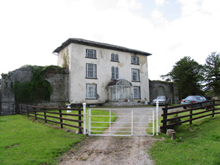
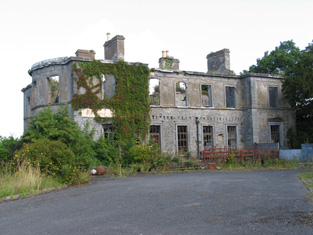
Oak Park
Houses within 15km of this house
Displaying 91 houses.
Houses within 15km of Oak Park
Displaying 91 houses.
| House name | Description | |
|---|---|---|
| Knockanacree Wood House | A house valued at £17+, occupied by Hawtrey Andrews and held from the Reverend Frederick F. Trench in the mid 19th century. Walford states that Hawtrey Andrews was the second son of Maunsell Andrews of Rathanny. This house is now demolished. | |
| Glenalbert House | Glen Albert House was the home of Albert E. Maxwell in 1837. In 1840 the Ordnance Survey Name Books note the opinion that "this is an Irish name fabricated at a very recent period". It was also occupied by A.E.Maxwell at the time of Griffith's Valuation when the house was valued at £30 and held from Dawson H. Vaughan. The Harte Maxwells were resident at Glenalbert in the first two decades of the 20th century. This house is now completely demolished. | |
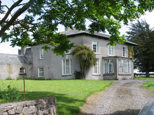
| Montevideo House | A house marked on the first edition Ordnance Survey map and occupied by Francis Smallman in the mid 19th century, when the buildings were valued at £20 and held from the Earl of Portarlington. The National Inventory of Architectural Heritage names this house Beechmount. |
|
| Bellpark | Occupied by T. Robinson in 1837. The Ordnance Survey Name Books record Eyre C. Baldwin as the proprietor in 1840. It was occupied by Thomas Goold in the early 1850s. Goold held the house valued at £17+ with 116 acres from Denis Leonard and was the tenant at the time of house of the 1852 sale. A house is still extant at the site. | |
| Bellgrove | The home of the Leonard family in the first half of the 19th century. The Ordnance Survey Name Books refer to Geoffrey Leonard as the proprietor in 1840 but note that the house was not inhabited. It was held by Denis Leonard in fee at the time of Griffith's Valuation when the buildings were valued at £25.10 shillings. This house was unoccupied at the time of the 1852 sale. It appears to have been bought by Hyacinth Richard Daly, who advertised it for sale again in 1863. The sale rental states that the dwelling house was in "an unfinished state". Bellgrove no longer exists. | |
| Fortmoy House Lower | In 1840 the Ordnance Survey Name books refer to "Fordmoy" as "a good dwellinghouse, lately built, the residence of Mr. Prendergast".This house was vacant at the time of Griffith's Valuation. Thomas G. Prendergast was the immediate lessor and the house was valued at £11. Buildings valued at £27.5 shillings were held by the representatives of David Clarke at Fortmoy in 1906. Fortmoy House Lower is still extant. |
|
| Spring Park | In the mid 19th century Benjamin Armitage occupied a house valued at £10 in Gortnagrann which he held with 243 acres from William Woods. The Ordnance Survey Name Books note it as being occupied by Mr. Armitage in 1841. The site is now occupied by farm buildings. | |
| Milford | Lewis records Milford as the occasional residence of Ralph Smith. By the early 1850s it was occupied by Thomas Bunbury and held from William Woods. Bence Jones writes that it was the home of Edmond Murphy who died in 1882. In 1840, he Ordnance Survey Name Books refer to the house as the residence of John Monsell and describe the demesne as "principally composed of plantation and ornamental grounds". |

|
| Lisbryan | Lisbrien or Lisbryan, near Ballingarry, was occupied by Faulkner Esq in the 1770s and 1780s. Sir Robert Waller Baronet was occupying this house in 1814. Lewis records T. Bunbury as the proprietor in 1837. The Ordnance Survey Name Books, also refer to it as his residence, "a very extensive building of the modern style". Thomas Bunbury held the property from Lord Ashtown at the time of Griffith's Valuation when the buildings were valued at £40+. Lisbryan is still extant. |

|
| Ballymona | Ralph Smith was resident at Ballymona in 1837 and in the early 1850s. The Ordnance Survey Name Books refer to the house as " a plain modern building" in 1841. Smyth held the property from Lord Ashtown and the buildings were valued at £25. This house is now a ruin. | |
| Fairyhill | Fairyhill was the home of William Henry Cox in 1837. The Ordnance Survey Name Books describe it as "a large mansion house, the residence of Mr. Cocks [sic]" in 1841. It was occupied by Ellen Robinson in the early 1850s, when the house was valued at £19 and held from Lord Ashtown. Valued at £16 in 1906 and held by George W. Robinson. This house is still in use as a residence. |

|
| South Park | In the 1770s Abbot Esq was residing at Rahanane close to Ballingarry. Wilson, writing in 1786, also refers to Rahanane as the seat of Mr. Abbott. The house is named South Park on the 1st edition Ordnance Survey map and was the home of a branch of the Atkinson family, occupied by Anthony Atkinson in 1814 and by C. Atkinson in 1837. Charles Atkinson held the property from Lord Ashtown at the time of Griffith's Valuation when the house was valued at £22. The estate of Edward Evans of Southpark, 174 acres in the barony of Lower Ormond, was advertised for sale in December 1859. South Park is still extant. |
|
| Ballingarry | Situated just north of Ballingarry castle Ballingarry House was built circa 1820. Lewis records Marmaduke Thompson as resident at Ballingarry Castle in 1837 as does the Ordnance Survey Name Books in 1841 though they refer to Lord Ashtown as the proprietor. The Thompson interest in Ballingarry and Ballinahinch was for sale in June 1850. Henry Trench was the occupier in the early 1850s holding the property form Lord Ashtown. Ballingarry House is still extant and occupied. |
|
| Redwood House | Redwood was the home of the Bloomfield family in county Tipperary, occupied by Major Bloomfield in 1837. In 1840 the Ordnance Survey Name Books mention that Redwood was "a commodious house, at present occupied by a party of the constabulary and also the residence of Mr. Ryan, under-agent to Maj. Bloomfield". It is marked as a police station on the 1st edition Ordnance Survey map. At the time of Griffith's Valuation. Phillip Crawley held the property from Lord Bloomfield and the house was valued at £15. Redwood House later became a Trench home, valued at £18.15 shillings in 1906. It no longer exists. | |
| Lismacrory | An early home of the Smith family in county Tipperary. Lewis writes that Lismacrony was the ancient residence of the family of Smith now the property of Mr Bunbury. This house was in ruins at the time of the first edition Ordnance Survey map. In 1841, the Ordnance Survey Name Books description says "it was a very commodious house of the modern style of architecture with extensive offices attached to it, but it is now falling into ruins, the last occupier was Rev. Mr. Smyth of Ballingarry". | |
| Ormond Cottage | Ormond Cottage was the residence of Samuel Waller in 1837 and is also noted in the Ordnance Survey Name Books which describe it as "a neat cottage". In the early 1850s he held it in fee and the buildings were valued at £15.10 shillings. It was included in the sale of 1856 sale. A building is still located at this site. | |
| Walsh Park | The home of the Walsh family in the 18th and first half of the 19th centuries. Taylor and Skinner record Walsh Esq as resident at Derrylaghan [Walshpark]. The Ordnance Survey Name Books refer to the demesne as having plantations and ornamental grounds and to the house as "a good dwelling house, the residence of Jonathan Walsh" in 1840. . In the mid 19th century it was occupied by the representatives of Jonathan Walsh who held the property in fee. The house was valued at £33. This house was demolished by the early 20th century. | |
| Derrylahan Park | Bence Jones writes that this house was built in 1862 at a cost of £15,000 to the design of Sir Thomas Newenham Deane. It was the home of William Henry Head, valued at £50.10 shillings in 1906. It was burnt in 1921. |

|
| Abbeville | Home of the Hemsworth family in the 18th and 19th centuries, occupied by Thomas Hemsworth in 1814. Thomas G. Hemsworth was resident in 1837 and in the early 1850s. Thomas George Hemsworth of Abbeville owned 387 acres in the 1870s. |
|
| Ballinderry | Occupied by the Saunders family from at least the 1770s. Owen Saunders was resident in 1814. He was related to the Sadleirs of Ballinderry. Lewis records Thomas Sadlier junior as the proprietor of Ballinderry "on which a house was about to be erected". Thomas Sadlier held the property in fee at the time of Griffith's Valuation when the buildings were valued at £29. At the time of the Saunders sale in 1877 this house was described as modern and substanial and "approached by a noble avenue lined with beech trees". It was in the owner's possession. Occupied by William J. Russell in 1906. This house is still a residence. | |
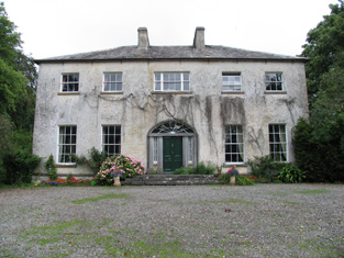
| Sopwell Hall | Apparently named after an English property, Sopwell in Hertfordshire, which was inherited by the Sadleir family. In 1655 a Cromwellian soldier, Colonel Thomas Sadleir, was granted Kinelagh Castle, county Tipperary, which he renamed Sopwell Hall. This property remained in Sadleir possession until it was inherited by Mary Sadleir who, in 1754, had married Frederick Trench of Woodlawn, county Galway, the parents of the 1st Lord Ashtown. The present house was built by Mary's father, Francis Sadleir, in the mid 18th century. Wilson refers to it as the residence of Mr. Sadlier in 1786. Sopwell Hall was left to Francis Trench, brother of 1st Lord Ashtown, who was living at Sopwell Hall in 1814. In 1837 Lewis records the Trenches in possession and writes that "on the demesne are the ruins of the ancient castle formerly occupied by the Sadleir family". The Ordnance Survey Name Books, in 1840, refer to Sopwell as "a spacious building, the residence of Stewart Trench". At the time of Griffith's Valuation the 2nd Lord Ashtown, son of Francis, was occupying the house, valued at £40 and held by him in fee. By 1906 Sopwell was valued at £80 and occupied by the Honourable Cosby G. Trench. The Trench family were still resident at Sopwell Hall in the 1970s. In 1840 the Ordnance Survey Name Books noted that Sopwell was one of the largest demesnes in the country. |

|
| Killavalla | Lewis records Killavalla as the seat of R. Johnston Stoney. The Ordnance Survey Name Books refer to the house in this townland as "Honeywood House, the residence of Robert Johnstone Stoney, very commodious with convenient offices attached". Stoney's representatives held the property valued at £16+ from the representatives of Stephen Egan at the time of Griffith's Valuation. It later became the seat of the Saunders family. This house no longer exists. |
|
| Greyfort Cottage [later Greyfort House] | The Stoneys were residing at Greyfort from at least the 1770s as recorded by Taylor and Skinner and also by Wilson in 1786. A house known as Greyfort Cottage was marked on the first edition Ordnance Survey map at this location and is also mentioned in the Ordnance Survey Name Books which refers to it as "a good dwelling house, the residence of Henry Owen Saunders". On later maps a different building in the townland is known as Greyfort House. Biggs A. Stoney was living at Grey-fort, Borrisokane, in 1814 and Saunders is recorded as the proprietor by Lewis. William Gray was the occupier of a house in Greyfort townland, valued at £12+, at the time of Griffith's Valuation and held from Henry O. Saunders. Thomas R. Grey of Greyfort House owned 500 acres in the 1870s. Buildings are still extant at this site. | |
| Ballyrickard House | Ballyrickard may possibly be the house known as Lettyville on the Taylor and Skinner map from the 1770s. Leet records Daniel Falkener as resident at Ballyrickard in 1814 and Lewis records N. Falkiner as the proprietor. The Ordnance Survey Name Books refer to Ballyrickard as "a commodious house", the residence of Nathaniel Falkiner. In the early 1850s Addison Hone was the occupier holding the property from Richard H. Falkiner. The buildings were valued at £15. This 18th century house is still extant and occupied. |

|
| Congor | Occupied by F. Falkiner in 1837 and described by the Ordnance Survey Name Books as "the commodious residence of Nicholas Biddulph" in 1840. It was still occupied by him at the time of Griffith's Valuation when the house was valued at £20. Nicholas Biddulph was still resident in the mid 1870s when he is recorded as owning 74 acres in county Tipperary. A building is still located at this site. | |
| Mount Falcon | Bence Jones writes that this house was built in 1720 by Richard Falkiner. It was the seat of the Falkiner family in the 18th and 19th centuries. The Ordnance Survey Name Books refer to it as the seat of Richard Fitzpatrick Falkiner (a minor) in 1840 and that it was occupied by Obediah Holan. At the time of Griffith's Valuation the house was valued at £15. It is still extant. |

|
| Clifton | Lewis records Clifton as the seat of Captain Sheppard. The Ordnance Survey Name Books refer to it as "a modern building, the residence of Capt. Sheppard" in 1841. Arthur Sheppard [?] was the occupier at the time of Griffith's Valuation. He held the property from Thomas Pyke and the buildings were valued at £14.10 shillings. The National Inventory of Architectural Heritage records the present house as dating from 1868. |
|
| Kyle Park | Marked on the first edition Ordnance Survey map Kyle Park was occupied by Thomas G. Stoney at the time of Griffith's Valuation and held by him in fee. It was valued at £39. The Ordnance Survey Name Books had described it as " a new and commodious house built and occupied by T.G. Stoney". The Stoneys still lived at Kyle Park in the 1870s. This house is still extant. |
|
| Arranhill | Arranhill was a Stoney home in the late 18th century. Thomas Stoney was resident in 1814 and Thomas George Stoney in 1837. In 1840 the Ordnance Survey Name Books report that "it suffered considerable damage during the storm of 6 and 7 January, 1839. It is occupied at present by Mr. Skelly, land steward to George Walpole, Brusna Mills, Roscrea". The Name Books also note the Marquis of Ormond as the proprietor. Thomas G. Stoney was the occupier in the early 1850s holding the property from the representatives of T.P. Firman. The buildings were valued at £23.10 shillings. This house is described as "in ruins" on the 25-inch Ordnance Survey map of the 1890s and some of these ruins remain. | |
| Firmount | The seat of the Firman family in the late 18th century, occupied by Thomas P. Terman in 1814. The house is marked on the first edition Ordnance Survey map. The Ordnance Survey Name Books refer to it as "the mansion house of Firmount now falling into ruins, It appears to be a ruin by the time of Griffith's Valuation. The only buildings over £10 valuation were the Santa Cruise flour mill and house of Samuel Palmer. The Irish Tourist Association surveyor records "an extremely charming house converted from stabling" at Firmount and occupied by Major H.H. Deasy in the early 1940s. The surveyor states that the original house was destroyed by fire. | |
| Finnoe | Occupied by T. [Thomas Maunsell] Waller in 1837. The Ordnance Survey Name Books describe Finnoe as "a commodious house" in 1840. Thomas' son, Edward Waller, was the occupier at the time of Griffith's Valuation. Edward held the property in fee and the house was valued at £30. A building is still located at this site. | |
| Arbourhill | A house occupied by J. Antisell in 1837. The Ordnance Survey Name Books describe it as "a good dwelling house, the residence of Joseph Antisell" in 1840. It was valued at £10 when held by Thomas Pyke in fee at the time of Griffith's Valuation. There is still an extant house at the site. | |
| Clongowna House | In 1840, he Ordnance Survey Name Books refer to this property as "Mount Ormond, a good dwelling house in a demesne of the same name, the residence of Rev. Mr. Troak" It is labelled on both the First and 25-edtion Ordnance Survey maps, however, as Clongowna House. Occupied by the Reverend Mr Troke in 1837 and by John Brereton at the time of Griffith's Valuation. John Brereton held the property in fee and the house was valued at £21. Still occupied by the Breretons in the 1870s. A house is still extant at this site. | |
| Gurteen | Lewis records J[ohn] Lalor as resident at Gurteen in 1837. He was a nephew of John Lalor of Crannagh and Long Orchard. The Orrdnance Survey Name Books also note Gurteen as his residence, describing it as "a good dwelling house". It was advertised for sale in July 1850. By the time of Griffith's Valuation,Michael Moyland held the house valued at £15+ and 234 acres in fee. George W. O'Brien of Gurteen, Parsonstown, owned 389 acres in county Tipperary in the 1870s. Mary Jane O'Brien held buildings valued at £12.10 shillings at Gurteen in 1906. |
|
| New Grove | Marked on the first edition Ordnance Survey map as New Grove, this house appears on the 25-inch map of the 1890s and is still known by the name, St Kierans. Occupied by J. W. Bayly in 1837 and described by the Ordnance Survey Name Books as " a good dwelling house, the residence of John Bayly" in 1840. It was occupied by Thomas Fetherston at the time of Griffith's Valuation and held from John Bailey. The buildings were valued at £19+. This property was advertised for sale in November 1851, the estate of John Washington Bayly. |
|
| Sraduff | Taylor and Skinner record Antisell Esq as the proprietor of Straduff in the 1770s. T. Antisell occupied Sraduff in 1837 and Christopher Antisell was resident in a house valued at £10+ in Sraduff in the early 1850s. The house was valued at £15+ in 1906 and was held by Monsell Antisell with 342 acres of untenanted land. This house is now a ruin. | |
| Rodeen | A Falkiner residence from at least 1837. It was the home of Joseph Falkiner who held the property in fee. He was one of the eleven sons of the Reverend R.D. Falkiner of Mount Falcon. The house was valued at £22. It was advertised for sale in July 1860, Mrs Anne Falkiner and Richard J. Falkiner were the tenants. The house came on the market again in May 1867, part of the 105 acres for sale at Rodeen, the estate of Octavius La Touche. This house is still in use as a residence. |

|
| Kilcarren | A house occupied by Ralph Smith in 1814 and by A. Carew in 1837. The Ordnance Survey Name Books describe it as "a good dwelling house" in 1841. Alexander Carew, a descendant of Lynn Carew, held the property from Ralph Smith in the mid 19th century when the buildings were valued at £17+. The house is still extant and occupied. |

|
| Lackeen | Lackeen House is an early 18th structure attached to part of a 17th century house. John Baily was the proprietor of Lackeen Castle, Parsonstown [Birr], in 1814 and in the mid 19th century the house valued at £12.10 shillings was occupied by Hamilton English and held from Lord Cremore. This house is now unoccupied. |
|
| Ballyquirk | In 1837 Lewis refers to the ruins of Ballyquirk castle "near which is a handsome modern house of that name". Colonel Henry Dwyer was the occupant in the mid 19th century, holding the house valued at £32 and 716 acres from Edward Newingham. |
|
| Harvest Lodge | The Stoneys were resident at Harvest Lodge from at least 1837. Thomas Johnston Stoney, born 1780, fourth son of Thomas Stoney of Arran Hill held the property in fee at the time of Griffith's Valuation, when the house was valued at £30. Harvest Lodge was the home of J.M. Wilson in the 1870s. This house no longer exists. | |
| Curraghglass | J.W. Walsh is noted as the proprietor of Curraghglass in the Ordnance Survey Name Books of 1841. In the mid 19th century Thomas Meara occupied a house valued at £11 and held from the representatives of Jonathan Walsh. There is still a building located at this site. | |
| Firville | In 1841 the Ordnance Survey Name Books refer to "Ferville" as the residence of R.F. Drought. William S. Smith occupied the house in the mid 19th century which he held from Ralph Smith. It was valued at £15+. This building is still part of a farm complex. | |
| Belle Isle | A house overlooking the River Shannon, originally the home of a junior branch of the family it became the property of the 3rd Lord Avonmore through his second marriage to Cecilia O'Keeffe. The seat of 3rd Lord Avonmore in the mid 19th century held by him in fee and valued at £48. Belle Isle was occupied by Thomas Maunsell in 1814 and by Lord Avonmore in 1837. This house is no longer occupied. |

|
| Portland Park | A residence of the Stoney family from at least the 1770s, when it was purchased from the Earls of Antrim. Occupied by Richard Stoney in 1814 and by J. Chapman in 1837. In 1841 the Ordnance Survey Name Books described it as "a spacious building, the residence of Thomas B. Stoney with a great demesne". At the time of Griffith's Valuation he held the property in fee when the buildings were valued at £40. Portland Park remained in the possession of the Stoney family until it was burnt in 1936 (Irish Times, 11 May 1936). It is now a ruin. |
|
| Redwood | Marked on the first edition Ordnance Survey map as Moatfield House and on later maps as Redwood. Moate-field, Burris-a-kane, was the home of William Clarke in 1814. In 1841 the Ordnance Survey Name Books refer to it as "Moat Field, a good dwelling house the residence of Miss Clarke". In the mid 19th century Robert Daly held a house valued at £15 and 324 acres in Redwood from Lord Bloomfield. Redwood is still extant. | |
| Bushy Park | Bushy Park was the home of Thomas Towers in 1814 and in 1837. In 1840, the Ordnance Survey Name Books refer to it as " a comfortable house, the residence of Thomas Towers" and also include reference to a letter written by Mr. Towers in which he expressed the wish that the house would revert to the name Shesharaghmore house though this does not seem to have happened. Sarah Cambie was occupying the house valued at £15 and held from Thomas Towers in the mid 19th century. David Clarke is described as "of Bushy Park, Borrisokane and Macclesfield" in the 1870s. Still valued at £15 this house was held by the representatives of David Clarke in 1906. A building is still extant at the site. | |
| Riverstown | The home of the Hackett family in the 19th century, occupied by Simpson Hackett in 1814 and in the 1830s and 1840s. Thomas Hackett was resident in the early 1850s and held the property from the Earl of Rosse. The house was valued at £29+. The Hacketts were still resident in the 1870s. This house is still extant and occupied and situated on the border of counties Tipperary and Offaly. In 2013 it was offered for sale. |
|
| Croghan | In 1841 the Ordnance Survey Name Books refer to "Croughane House" as the residence of Francis Drought. Michael Mullarchy was leasing it from James Fleetwood at the time of Griffith's Valuation when Croghan was valued at £15. This house is still in use as a family residence. |
|
| Behamore | The Reverend Thomas Hawkshaw was resident here in 1814 and Benjamin Hawkshaw in 1837. The Ordnance Survey Name Books also note it as his residence, describing Behamore as "a commodious house". James Fleetwood was the occupier in the early 1850s holding the property from Lord Dunalley, it was valued at £13+. A building is still located at this site. | |
| Elm Hall | Lewis records Elm Hall as the residence of Peter Burke while the Ordnance Survey Name Books refer to it as that of "Counsellor Burke". By the time of Griffith's Valuation his son Joseph Burke was the occupier, holding the property in fee, the house was valued at £10. A farm building now occupies the site of Elm Hall. |
|
| Carrig | The National Inventory of Architectural Heritage describes this as a miller's house. In 1840 The Ordnance Survey Name Books refer to it as " a good dwelling house, the residence of Christopher Dignan, there is a good flour mill close by". William Abernethy held it from the Earl of Portarlington in the mid 19th century when the house was valued at £20. It is now a ruin. James Abernethy of Carrig owned 113 acres in county Tipperary in the 1870s. |
|
| Gurteen | Gurteen was the home of Willliam Smith in 1814 and of George Smith in 1837. At the time of Griffith's Valuation George Smith held the property from Lord Ashtown. The buildings were valued at £13. The Smiths were still living at Gurteen in the 1870s. Gurteen is now the centre of an agricultural college. http://www.gurteencollege.ie/index.html | |
| Lacka | Lewis records W. Cruess as proprietor of Lacka in 1837. On the first edition Ordnance Survey map a small house named Ash Grove is marked in the townland of Lacka S024 979. Later maps mark Lacka House at the crossroads. Griffith's Valuation names William N. Cruise as the occupier of a house valued at £10 in Lacka. He held the property and 335 acres from William Abernethy. The buildings were valued at £10. In the 1870s Samuel R. Cruess of Lacka owned 365 acres and William V. Cruise of Nenagh owned 121 acres. | |
| Baronne Court | The Ordnance Survey Name Books refer to Tinnakilly House and Observatory in the townland of Stonestown, the residence of Robert Robinson in 1840. The property was for sale in the Encumbered Estates' Court in February 1851. The sale details state that it was erected at a cost of £6,000 in 1830. It was altered by the Marshalls and renamed Baronne Court. Reverend Joseph Marshall is recorded as the occupier of the house valued at £53 at the time of Griffith's Valuation. The Reverend Joseph held the property in fee. William K. Marshall was recorded by Slater as the proprietor in 1894. This house is now demolished although the farm buildings still remain. |

|
| Ballynavin | According to the National Inventory of Architectural Heritage the origins of this building date back to the mid 17th century. Ballynavin was a Robinson home in the 19th century, occupied by Mrs Robinson in 1837 and by Reverend Robert Robinson in the early 1850s. He held the property in fee and the buildings were valued at £18. Robert Robinson lived at Ballynavin in the 1870s. The house is still in use as a residence. |

|
| Wingfield | A house located just inside the county Tipperary border with county Offaly. The property belonged to John Shortt in the mid 18th century. When he died in 1768 his widow Frances (nee Spunner) married Jonathan Doolan. Wingfield was occupied by Jonathan's son Thomas Doolan in 1814 and in 1837. The Ordnance Survey Name Books refer to it as the residence of [Paliner?] Thomas Doolan in 1840. By the time of Griffith's Valuation Henry Spunner was resident. He held the property from Jonathan Short and the buildings were valued at £20. Richard Thomas Croasdaile and his sister Margaret occupied the house in 1901. This house is now a ruin. |
|
| Northland | Northland was the residence of Sir A. Dancer in 1814 and of William Smith in 1837. By the time of Griffith's Valuation William Henry Head occupied this house valued at £10. He held the property from Lord Dunalley. The house was demolished by the early 20th century. | |
| Willow Lodge | James Fleetwood was resident at Willow Lodge in 1814 and in 1837. By the time of Griffith's Valuation the house appears to be only valued at £1 and occupied by David Tierney. Willow Lodge is marked on the first edition Ordnance Survey map. It is named Alma on the 25-inch map of the 1890s. There is still an extant house at the site. | |
| Riversdale | This house was built after the first Ordnance Survey. At the time of Griffith's Valuation Thomas S. D. Robinson is recorded as the occupier of a house valued at £15 in the townland of Ballynavin. He held the property in fee. Thomas S.D. Robinson was still living at Riversdale in the 1870s. This house continues to be used as a residence. |

|
| Deer Park | Lewis records Park House as the property of William Trench but the residence of De La Pere A. J. Robinson. The Reverend Frederick F. Trench was the occupier in the mid 19th century, holding the house valued at £23 from Lord Dunalley. This house still functions as a residence. |

|
| Cloghkeating | The home of Augustus Robinson from the 1830s. The Ordnance Survey Name Books refer to Cloghkeating as "a large new house" in 1841. At the time of Griffith's Valuation Augustus Robinson held the property in fee and the buildings were valued at £19. Augustus Robinson of Cloghkeating owned 231 acres in the 1870s. This house is still in use as a residence. |

|
| Cloghjordan House | This house was the home of the Reverend Edwin Palmer in 1814. By the time of Griffith's Valuation John Hodgins occupied the house and ran the nearby nursery gardens. The buildings were valued at £13+ and held from Lord Dunalley. This building which includes the remains of the old castle still functions as a country residence. |
|
| Tenessee | This house is labelled Tenessee House on both the First and 25-inch edition Ordnance Survey map. In 1841 the Ordnance Survey Name Books suggest that it was the property of Lord Dunally. In the mid 19th century it was occupied by Thomas R. Barnes and held from Joseph Falkiner. The buildings were valued at £14. 15 shillings. The house is still in use as a residence. |

|
| Coolnamunna | At the time of Griffith's Valuation Edward Kennedy held buildings valued at £34+ from Ellen Lloyd [widow of Henry Jesse Lloyd of Castle Iney?] in the townland of Coolnamunna. He had a distillery in Mullenkeagh valued at £47. Edward Kennedy of Coolnamoner Park owned 432 acres in county Tipperary in the 1870s. |
|
| Fort William | A Parker residence in the early part of the 19th century. In 1841 the Ordnance Survey Name Books referred to it as "a splendid demesne and fine mansion house, the residence of Mr. Parker". By the time of Griffith's Valuation Fort William was occupied by Miss Crawford who held the property from Messrs Egan. The buildings were valued at £18.15 shillings. The Egan sale rental of 1854 gives details of the original lease which was from Charles Egan to John Greene in 1769 for three lives renewable for ever. The last renewal was dated 1803 from John Egan to William Crawford. This house is still in use. |

|
| Modreeny House | In 1786 Wilson refers to "Moderenny" as the seat of Sir Amyrald Dancer. The Ordnance Survey Name Books refer to the house as Eminisky House in 1841 but it is marked on the first edition map as Modreeny House and was the home of the Dancer family. It was replaced by a new house circa 1920s. The outbuildings, gates and gatelodge of the original house still remain. At the time of Griffith's Valuation Sir Thomas B. Dancer held this property in fee. The buildings were valued at £21. Hussey gives Modreeny House as the address of Sir Thomas Dancer in 1878. |
|
| Hilton | Hilton, located just to the south of Modreeny House, was the home of Thomas Dancer, later 6th Baronet, in 1837 and of the 6th Baronet's son, Thomas J. Dancer, in the mid 19th century. Thomas J. Dancer held the house valued at £15 from his father Sir Thomas B. Dancer, 6th Baronet. In 1841 the Ordnance Survey Name Books had noted the house as the residence of Thomas Stoney. A house is still located at this site. | |
| Elysium | This house is marked on the first edition Ordnance Survey map and was inhabited by Thomas Ely in 1837. Thomas Ely held the property in fee at the time of Griffith's Valuation when the house was valued at £23. The Elys were still resident in the 1870s. George Evans was occupying this house in 1906. There is still a house located at this site. | |
| Modreeny | Lewis records W. H. Head as the proprietor of Modreeny House in 1837. He was still resident at the time of Griffith's Valuation and held the house valued at £35 in fee. Burke's ''Landed Gentry of Ireland'' (1904) records William Henry Head's father as "of Modreeny House". In 1906 the representatives of George Whitfield were the occupiers and the house was valued at £36.10 shillings. George Whitfield of Modreeny owned 443 acres in the 1870s. In 1890 his daughter Kathleen married Sir Francis Osborne, Baronet. This house was bought by Donald Swan in 1965 and Charlie Swan, champion jockey, was born at Modreeny in 1968. |
|
| Mertonhall | Merton, Cloghjordan, was the home of T.G. Fitzgibbon in 1814. It was purchased by Robert Hall in 1828 and he was the proprietor in 1837. The Ordnance Survey Name Books noted in 1841 that it was formerly known as "Litty Ville House". The house was valued at £55 at the time of Griffith's Valuation and held by Robert Hall in fee. The Hall family continued to use Merton as a residence in the 1870s. By 1906 the representatives of De Courcy P. Ireland were occupying Mertonhall. He was married to Ada Hall. This house is now demolished. | |
| Coorevin | Lewis records Cooreavan as the property of R. Hall in 1837. In 1840 the Ordnance Survey Name Books indicate that it was occupied by "Mr Gorey Baker, Burresokane". Jeremiah P[ierce] Scully was the occupier at the time of Griffith's Valuation, holding the property from the representatives of Robert Hall. The buildings were valued at £11. A building is still located at this site. | |
| Uskane | Carrol Esq was resident at "Iscane" in the 1770s and 1780s. In 1837 R. Hall was the proprietor of Uskane House. In 1840 the Ordnance Survey Name Books note it as "a good dwelling house, the residence of Mr. Kent". It was held by the representatives of Robert Hall in fee at the time of Griffith's Valuation when the house was valued at £8. This house is still in use as a residence. |
|
| Fort Nisbitt | Robert Nesbett was resident at Fort Nesbett in 1814. The Ordnance Survey Name Books also mention him in 1839 though they refer to Thomas Towers as the proprietor of the townland. In the early 1850s, Thomas O'Brien was the occupier, holding the property from the Reverend James Nesbitt. The buildings were valued at £12.15 shillings. A building is still located at this site. | |
| Slevoir | Lewis records R. Monsell as resident at Slevoir in 1837. The Reverend Francis Synge was the occupier at the time of Griffith's Valuation, holding the property from the representatives of Mr Steele. The buildings were valued at £34. The National Inventory of Architectural Heritage states that the present house was built in the Italianate style in the 1870s for Lieutenant Colonel J.F. Hickey by John McCurdy. In the early 1940s General Carlos J. Hickie was the owner and the house contained very beautiful furnishings and valuable family pictures according to the Irish Tourist Association surveyor. This house sold for over £3 million in 2000 and was offered for sale again in 2011. |
|
| Ashgrove | Lewis records B. Talbot as resident. In 1840 the Ordnance Survey Name Books record that the house derived its name from "a large ash grove, recently cut away". A house valued at £15+ at the time of Griffith's Valuation when it was occupied by Reverend Benjamin Talbot and held from Sir John Power. Reverend Benjamin was still resident in the 1870s. Ash Grove is still extant. |
|
| Derrinvohil | This house was not built at the time of the first Ordnance Survey. It bears the name of a townland but was originally located in the townland just to the west of Derrinvohil. The townland boundary has now altered and the house is in the townland of Derrinvohil. It was built by James Jocelyn Poe in 1845. Valued at £17 at the time of Griffith's Valuation and held from the Messrs Saurin. The house continues to function as a residence. |
|
| Castle Sheppard | The Sheppards were living here from at least the 1770s.In 1786 Wilson refers to Castle Sheppard as the seat of "Mr. Shepherd". It was the home of a junior branch of the family. William Sheppard was resident in 1837 and in the early 1850s when the house was valued at £26 and held from Lord Ashtown. William died at Castle Sheppard in 1852 without heirs and both his brothers died unmarried in India. Valued at £18 in 1906 and occupied by the Honourable Cosby G. Trench. This house is now a ruin. | |
| Somerset | The National Inventory of Architectural Heritage states that this house was built in 1875. It appears to have replaced an earlier house also known as Somerset marked on the first edition Ordnance Survey map circa 1840. In 1841 the Ordnance Survey Name Books refer to Somerset as "a small demesne and good dwelling house, the residence of Mr. Going". It was the home of John O'Meara in the mid 1870s. In 1906 William H. O'Meara occupied a house valued at £12+ in the townland of Abbeville. |
|
| Annagh | In 1841 the Ordnance Survey Name Books describe Annagh as "a good dwelling house, the residence of John Kennedy". At the time of Griffith's Valuation, it was valued at £10, occupied by John Kennedy and held from George Kinahan. In 1906 held by the representatives of George Bolton. This house is now a ruin. | |
| Lisheen (Lower Ormond) | In 1840 the Ordnance Survey Name Books refer to Lisheen House in the parish of Aglishcloghane as held by John Crawford but an addendum to the entry on the parish of Uskane note that Lisheen was the residence of Geo.Fosbery, Jnr. By the time of Griffith's Valuation it was held in fee by George Fosberry and valued at almost £8. A house is still extant at the site. | |
| Rockview (Dorrha) | In 1840 the Ordnance Survey Name Books refer to Rockview House as "a good mansion house, the residence of Captain Corrigan". By the time of Griffith's Valuation this house was occupied by John Hemsworth, leasing from Mary Nunn and representatives of Richard Donovan. The buildings were valued at almost £7. Rockview House is still extant. |
|
| Ross Cottage/House (Dorrha) | In 1841 the Ordnance Survey Name Books refer to Ross Cottage as "an elegant built cottage, the residence of Mr. Smyth", the proprietor of which was R. Hemsworth. The house is labelled as "Ross House" on both the 1st and 25-edition Ordnance Survey maps. By the time of Griffith's Valuation, it was occupied by Thomas Hernon, leasing from John J. Hemsworth and the buildings were valued at almost £8. The house is still extant and occupied. |
|
| Roden House | In 1841 the Ordnance Survey Name Books describe Roden House as "a good dwelling house". C.W. Hemsworth is noted as the proprietor. At the time of Griffith's Valuation, it was occupied by Thomas R. Deane, leasing from Thomas Hackett, when the buildings had a valuation of almost £3. The National Inventory of Architectural Heritage dates this property to 1784. It is still extant and occupied. |
|
| Loughkeen Glebe | In 1840 the Ordnance Survey Name Books describe the Glebe at Loughkeen as "a good dwelling house the residence of Rector Synge". At the time of Griffith's Valuation, it was leased by Reverend Francis Synge from the Ecclesiastical Commissioners and valued at £23+. It is still extant and occupied. |
|
| Ivy Hall (Loughkeen) | The Ordnance Survey Name Books refer to Ivy Hall as the residence of Richard Palmer in 1840. By the time of Griffith's Valuation, it was occupied by Mary Anne Palmer, who was leasing from William Abernethy, and valued at almost £8. Ivy Hall is still extant and occupied. |
|
| Rockville (Loughkeen) | The Ordnance Survey Name Books refer to Rock Ville House in the parish of Loughkeen as the residence of Mr. S. Lloyd in 1841. At the time of Giffith's Valuation, a house in this townland valued at £10 was occupied by William Kent, leasing from Jane Downs. On the 25-inch map of the 1890s this house is labelled Carrig Cottage. It is still extant. | |
| Millpark Mill Cottage | In 1840 the Ordnance Survey Name Books refer to Millpark House as the residence of Mr. Lyster. At the time of Griffith's Valuation Hamilton Lyster was leasing a property in the townland of Millpark from Robert Acres. It included a house and mill and was valued at £53. Some ruins of the mils still remain. A building is still extant on the site of Millpark Cottage. | |
| Millpark House | At the time of Griffith's Valuation, Adam Acres is recorded as the occupier of Millpark House, which he was leasing from the Vaughan estate. The house was valued at £18. It is still extant. | |
| Clonfinane House | In 1841 the Ordnance Survey Name Books refer to a house in the townland of Clonfinane as Moorefield House. There is reference to a communication from the Earl of Portarlington that he did not know of any such place on his estate with a following note by John O'Donovan stating "but your tenant built a house and gave it a name"! The house is described as " a good dwelling house, the residence of Maunsell Antisell". However, on the 1st edition Ordnance Survey map, the house is labelled "Clonfinane House" perhaps indicating that Lord Portarlington prevailed. At the time of Griffith's Valuation, the house in this townland is occupied by the representatives of Jonathan Walsh and valued at almost £4. A house and farm are still extant at the site. | |
| Fort Henry [Greyfort Cottage] Borrisokane | In 1840, the Ordnance Survey Name Books refer to "Fort Henry, a commodious house, the residence of Henry Ely" in the townland of Greyfort, parish of Borrisokane. At the time of Griffith's Valuation, Henry Ely was leasing a property valued at almost £5 from the Saunders estate in this townland. This may refer to the property shown on the 1st edition Ordnance Survey map as Greyfort House. On the later 25-inch map of the 1890s it is known as Greyfort Cottage. A house is still extant at the site. |