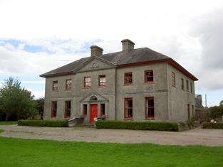
Belfort
Houses within 10km of this house
Displaying 38 houses.
Houses within 10km of Belfort
Displaying 38 houses.
| House name | Description | |
|---|---|---|
| Garrane | A house located on the Wyse Minors estate in the mid 19th century, occupied by Margaret Hartigan and valued at £11+. This house is barely marked on the first Ordnance Survey map. | |
| Fort House | The residence of David Hartigan in the early 1850s, held from William and Charles Wyse (minors) and valued at £13. | |
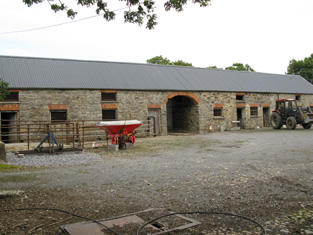
| Drewscourt | Home of the Drew family in the 18th and early 19th century. Drew's Lodge, Charleville, is listed as the residence of F. Drew in 1814 and Lewis refers to Drew's Court as the residence of the Drew family. The house appears to be vacant at the time of Griffith's Valuation and was in the possession of Henry Thomas Allen who held land from Francis Drew. Clennel Frank Massy Drew occupied this house in 1906, valued at £18. Drewscourt was burnt down in the 1920s but the farmyard complex remains. |
|
| Bruree Lodge | Bruree was the home of the Langton family in the 18th century. The house was occupied by Michael Ryan at the time of Griffith's Valuation and held from Michael Shaughnessy, it was valued at £13+. |
|
| Coolrus House | The residence of Richard Harte circa 1840 and of James Lynch in the early 1850s who held the property and 186 acres from the Court of Chancery. The house has diminished in size by the publication of the 25-inch edition Ordnance Survey map in the 1890s and it is no longer extant. | |
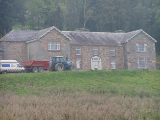
| Bruree House | Bruree House was also located on the Langton estate although at the time of the first Ordnance Survey the property was in the hands of Robert Fetherston who held a number of townlands in the parish, possibly from the Langtons. At the time of Griffith's Valuation the house was in use as an auxiliary workhouse. In 1853 Bruree House was sold to a member of the Shelton family and in 1868 it was sold to John Gubbins of the Kilfrush family. He was a successful racehorse owner and in 1884 built the present Bruree House. When he died in 1906 the property passed to his nephew John Norris Browning. The house was valued at £92 at this time. Owned by the Sheehans and Vernons in the 20th century. Now function as as a rehabilitation centre, known as Cuan Mhuire. A print entitled "The Lawn Meet" by Patrick Hennessy depicts this house. See www.museum.limerick.ie |

|
| Clogher West | A house occupied by John Fitzgerald and held from George Whitelock at the time of Griffith's Valuation. The buildings were valued at £12. The original house does not appear to be extant. | |
| Maidstown Castle | Originally known as Ballyvenoge, Seoighe writes that John Ormsby first lived at Maidstown which he sold to the Webbs when he went to live at Athlacca. By the mid 18th century the Webbs had sold Maidstown to the Gubbins. The home of a branch of the Gubbins family in the late 18th century and early 19th century. The house was valued at £20 and held by Patrick Coll from John White in the mid 19th century. The Colls sold Maidstown to the O'Regans in 1972. A house is still extant at the site as well as the ruin of the original tower house. | |
| Maiden Hall | Maidenhall was the residence of Boucher Esq in the 1770s and in 1786. Home of the Holmes family in the first half of the 19th century. R. Low Holmes was occupying the house in 1837 and Mrs Susan Holmes in the early 1850s. She held the property from the Reverend Benjamin W. Bradshaw. The buildings were valued at £14. A house is still extant at the site. | |
| Creggane Castle | A property associated with the Hutchins family, occupied by John Quaid at the time of Griffith's Valuation and held from Samuel Hutchins. The buildings were valued at £17. The sale rental 1857 records that the original lease dated 1802 was from Edmund Earl of Cork and Orrery to Emanuel Hutchins. Farm buildings occupy the site. | |
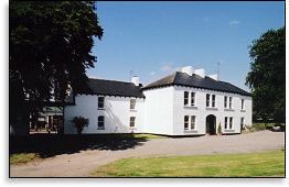
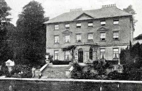
| Mount Coote | The county Limerick seat of the Coote family in the 18th and 19th centuries. Wilson refers to it as "the pleasant seat of Mr. Coote" in 1786. It was occupied by Chidley Coote in 1814. Lewis refers to it as the former seat of Chidley Coote in 1837. Charles Coote was resident at the time of Griffith's Valuation and held the property in fee. The buildings were valued at £53. Their value had increased to £65 by 1906. The Irish Tourist Association surveyor wrote in 1943 that the house was bought by Sir Gilbert Greenall, who became 1st Lord Daresbury, who spent about £200,000 setting up a Model Farm. [Lord Daresbury also owned Clonshire]. Following his death three years previously it was sold and then run as a stud farm. Bence Jones writes that this house was demolished circa 1960 and a new house built in the Georgian style. |

|
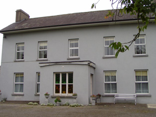
| Riversfield | A house located on the Coote estate, occupied by Thomas Weldon in 1837 and at the time of Griffith's Valuation when the buildings were valued at £20. John H. Weldon of Riversfield owned 68 acres in county Limerick in the 1870s. Occupied by Mr and Mrs Watt in 1943. It is still extant. | |
| Millmount | Occupied by the Reverend Joseph Gabbett and held from Daniel Gabbett at the time of Griffith's Valuation, when the buildings were valued at £16. It is labelled Millmount on the First Edition Ordnance Survey Map and as Ardvullen on the later 25-inch edition of the 1890s. A house is still extant at the site. | |
| Mount Russell | The home of James Russell in 1837 and at the time of Griffith's Valuation. The buildings were valued at £30 and James Russell held the property and 750 acres in fee. It is labelled as "in ruins" on the 25-inch Ordnance Survey map of the 1890s and nothing now remains. | |
| Ash Hill Towers | The residence of a branch of the Coote family in the 18th century, possibly held from the Barons Carbery. Ash Hill is referred to by Wilson as the seat of Chudleigh Coote in 1786. Bought by Eyre Evans from Chidley Coote in 1794 (see sale rental 6 July 1878). Eyre Evans held the property in fee throughout the first half of the 19th century. The Ordnance Survey Field Name Book describes this house as having "a most superb new front with towers at each end". At the time of Griffith's Valuation the buildings were valued at £50. Bence Jones writes that Ash Hill Towers became the residence of John Henry Weldon in the later 19th century. The Irish Tourist Association surveyor wrote in 1943 that the property was owned by Captain P.M. Lindsay, nephew of John H. Weldon, who bought the house from the Evans family in 1880. Still extant, this house is the centre of a stud. |
|
| Cappanihane | This house was occupied by John Mason in 1814, by R. Mason in 1837 and in use as an auxiliary workhouse at the time of Griffith's Valuation, when the buildings were valued at £15. This house was the home of John Parker Graham in the 1860s and 1870s. Another house in this townland, Glenbrook Lodge, was occupied in the early 1850s by Myles Mason and valued at £9+, grid reference R492 318. Mary Hamilton held a mansion house valued at £20 and 41 acres of untenanted land at Cappanihane in 1906. | |
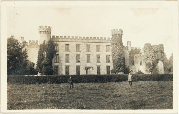
| Castle Harrison | An early 18th century house, the seat of the Harrison family until the 1950s. According to Lewis it was built on the site of Castle Dod, an old Fitzgerald castle and was inhabited by Standish Harrison in 1837. A map dated 1736 in the National Library includes a drawing of the house then known as Castle Dodd. In the 1940s the Irish Tourist Association Survey noted that it was the residence of Mrs. Harrison, widow of General Harrison. It provides a description of the great hall which contained artefacts that had been unearthed on the estate during the construction of the nearby railway. Castle Harrison was inherited by five sisters in 1951 and the estate was sold to the Land Commission in 1956. The house was subsequently demolished. | |
| Gubleagh House | The buildings at Gubleagh House, Annagh South were valued at £13 at the time of Griffith's Valuation and the house was occupied by Johanna Cowhy who held it and 189 acres from Sir Edward Tierney. This house is still occupied. | |
| Clashganniv | Hajba writes that this house has always been the home of the O'Brien family. Vincent O'Brien, the famous Irish race horse trainer, was born at Clashganniv in 1917. The house is still extant and occupied. At the time of Griffith's Valuation there were two houses in Clashganniv, one valued at £16, was occupied by James Lynch and the other valued at £10 was held in fee by Sir Edward Tierney. | |
| Castle Wrixon | A Wrixon property in the 18th century, occupied by John Wrixon in 1814 and Hajba writes that it was sold by the Wrixons to the Crofts in the mid 19th century. At the time of Griffith's Valuation it was occupied by John Connor who held it from Wills G. Crofts. The buildings were valued at £11. Christopher Crofts of Velvetstown House (died 1913) lived at Castle Wrixon for a time. He inherited Velvetstown from his uncle, Reverend Henry, in 1869. In the 1940s the Irish Tourist Association Survey outlined subsequent owners and noted that it was, by then, the residence of the McDermott family. It is still extant. |
|
| Baily Ville | Situated on the Neville estate this house was built by the Baily family in the mid 19th century. It is marked on the first Ordnance Survey map, circa 1840. By the 1870s Richard Gregg was living in the house which was then known as Oakville. He owned 405 acres in county Cork. Hajba writes that Gregg sold his interest in the property to the Fitzpatricks in the 1880s and this family was still in residence in the early 21st century. | |
| Cooliney House | Hajba writes that Cooliney was originally part of the Bowerman estate and that the house was rebuilt in the mid 18th century. It passed through marriage to the Nevilles of Furnass, county Kildare. Occupied by Mr Thomas Weldon in 1814 and by R. Weldon in 1837. At the time of Griffith's Valuation Robert Weldon held the house and 85 acres from James Hill. The house was valued at £20. In the 1940s the Irish Tourist Association survey noted that it was then the home of the Goold family. The house was restored in the 21st century. |
|
| Milltown Castle | Originally the home of Thomas Evans, a younger brother of the 1st Baron Carbery, and of his son Eyre Evans. Mary, sister of Eyre Evans, married George Bruce in the mid 18th century. The Castle was subsequently leased by the Evans to the Bruces and it remained the home of the Bruces until the late 19th century. Described by Lewis as “a handsome castellated mansion in the later English style”. Reduced in size in the early 20th century. The Irish Tourist Association Survey of the 1940s noted that the buildings, at that time the residence of the Keane family, were not in good repair. However, the building continues to be occupied. |
|
| Gibbings Grove | This house was the seat of the Gibbings family in the 18th and early 19th centuries. The family was still resident in 1837 but by the early 1850s the house was occupied by Edmond Irwin who held it form Richard Gibbons. It was valued at £14. Later occupants were local priests and it was eventually sold by the Gibbings in the late 19th century. In 1944 the Irish Tourist Association Survey referred to it as the home of the Cagney family who had purchased the property c.1912 and also that it was famous for growing the Toormore apple, used in making cider. The house is still occupied. |

|
| Ballyteige | Originally the home of a branch of the Tuthill family, no large house is marked on the first Ordnance Survey map in this townland. The house was leased to David Conyers of Castletown Conyers in 1885 and to Thomas W. Westropp Bennett in the 1890s. It is now available for hire, see http://www.ballyteigue.com/ |
|
| Glanmore | A Russell home in the 19th century, Hajba writes that it was bought by Michael Russell of Mount Russell from the Tynte family in 1815. Occupied by Michael Russell at the time of Griffith's Valuation it was held by him in fee. The buildings were valued at £24. The family were still resident in the mid 20th century and the house is still extant. It is labelled Ballynaboola House on the 1st edition Ordnance Survey map but as Glanmore on the 25-inch edition of the 1890s. |
|
| Woodville | Built as a shooting lodge for the Holmes family, occupied by Richard Sherlock in 1814 and by Captain William Harrington Sherlock at the time of Griffith's Valuation and bought by him in the Encumbered Estates' Court. His daughter married George Washington Brasier Creagh and the house remained in her possession until the 1920s. It is now a Crofts residence. | |
| Ballyhoura Lodge | Ballyhoura Lodge was occupied by Christopher Crofts at the time of Griffith's Valuation. He held the property from the representatives of Robert Holmes and the buildings were valued at £23. The house is still a family home. |
|
| Fortlands | Fortlands was occupied by members of the Batwell family in the first half of the 19th century. Hajba writes that the Batwells held the property from the Hutchins family. By the mid 19th century Samuel Hutchins was occupying the house, held by him in fee and valued at £31+. The home of the O'Connor family in the 20th century. The original house does not appear to be extant. | |
| Sanders Park | Late 18th century house, the seat of the Sanders family, occupied by William Saunders in 1814 and by C. Saunders in 1837. Griffith's Valuation records William R. Saunders holding the property from the Earl of Cork, the buildings were valued at £34+. The Irish Tourist Association Survey of the 1940s stated that it was then the residence of Mr. Binchy, a merchant in Charleville. It was converted into flats in the latter half of the 20th century but the building was derelict at the beginning of the 21st century. Also known as Charleville Park. |
|
| Newtown | Hajba dates this house from 1749 when it was built as a hunting lodge for the Courtenays. Described by Lewis in 1837 as the seat of Robert Courtney, John Culhane was resident by the time of Griffith's Valuation, holding the property from John Courtnay. The buildings were valued at £13. In 1943 the Irish Tourist Association Survey noted that it was then the home of the Culhane family. The house was demolished in the 1960s. | |
| Newtown | The seat of the Knight family in the 18th century now demolished. Wilson refers to Newtown as the seat of Mr. Knight in 1786. This house was occupied by Michael Connor in the early 1850s, valued at £8 and held from Mrs Eliza Sealy. A later house now stands on the site. | |
| Curryglass | Originally a Goold home, occupied by B. Plummer in 1814 and Pierce Purcell Goold in 1837. His representatives held the property in fee at the time of Griffith's Valuation and the house was valued at £18. It was advertised for sale in May 1852. Home of Robert Edward Gibbings for sometime in the mid 19th century. An O'Callaghan home in the 20th century. Also known as Curraghglass or Curraglass House. In 1943 the Irish Tourist Association Survey noted its association with all of these families as well as, in the eighteenth century, the Lysaght family. It is still extant and occupied. |
|
| Gortskagh | No house of more than £5 valuation is recorded in Griffith's Valuation in Gortskagh except the glebe house at £26. This house was occupied by Reverend William Bunbury who held the property from John Courtenay. The Deane connection with Gortskagh commenced with the marriage in 1871 of Honourable Matthew J.H.F. Deane, uncle of the 4th Baron Muskerry, with Maria, daughter of Reverend William Bunbury. The Deanes sold the house to the Binchy family in the 1890s. Home of the Foley family in the early 21st century. |
|
| Springfort | Dating from the very early 18th century, Springfort was the home of the Vowell family in the 18th century but Mr Cox is recorded as the proprietor in the late 1770s. By 1837 the Reverend Jonathan Bruce was resident. In the early 1850s William Carroll occupied the house holding the property from William Cox. The buildings were valued at £11+. This house was still extant in the 1980s when it was the home of the Cagneys. | |
| Moatville | Located on the outskirts of Charleville this house was occupied by Mrs Ryan in 1837 and of Michael Ryan at the time of Griffith's Valuation. Moatville was later the birthplace of Dr Reeves, Bishop of Down, Connor and Dromore. In the 1940s the Irish Tourist Association Survey described it as "a quaint high house, the residence of Mr. Ball". It is still extant. |

|
| Mount Blakeney | Mount Blakeney is south west of the town of Kilmallock and very close to the border between counties Limerick and Cork. No large house is marked in the townland of Mount Blakeney on the first Ordnance Survey map (Sheet 47). In 1786 Wilson refers to Mount Blakeney as the seat of Mr. Blakeney. At the time of Griffith's Valuation the townland was in the possession of Mrs. Blakeney Fitzgerald. In 2022 Mount Blakeney was offered for sale. |

|
| Holmesfort | In the 1940s the Irish Tourist Association survey notes that a house at Shinanagh, parish of Imphrick, was occupied by Major Thomas Holmes in the early nineteenth century and known as Holmesfort. It was replaced in the 1830s by another house, built by an O'Connor family. By the 1940s it had become the home of the O'Regan family. A house and farm buildings are still extant at the site. |