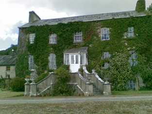
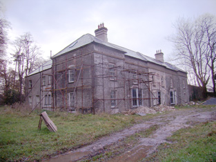
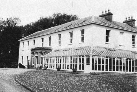
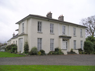
Kilteely House
Houses within 10km of this house
Displaying 38 houses.
Houses within 10km of Kilteely House
Displaying 38 houses.
| House name | Description | |
|---|---|---|
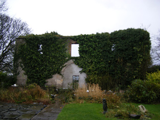
| Linfield | This house was the residence of Darby O'Grady in 1837 and the early 1850s. He held it from the Lloyd Apjohn family who subsequently lived in it. Sold by the Lloyd Apjohns following the death of Michael Marshall Lloyd Apjohn in 1895. This house was a ruin until recently renovated and is now inhabited. |

|
| Cahercorney | Not named on the the 1st edition Ordnance Survey map, this house was the residence of Henry Croker at the time of Griffith's Valuation. It was valued at £10+ and was held from John Croker. Earlier, in 1786, Wilson refers to it as the seat of Mr. White. A farm is extant at this site now. | |
| Loughgur Castle | In 1786 Wilson refers to Lough-Gur as the seat of Henry Baylee. This house was ccupied by John "Boylie" in 1814 and by Miss Bailie in 1837. In the early 1850s William Evans was resident. He held the house valued at £11 from the Count De Salis. It was adjacent to the remains of a tower house known as Bouchier's Castle. The property at this site is labelled "Lough Gur Farm" on the 25-inch map of the 1890s. The book edited by Mary Carbery, "The Farm by Lough Gur", published in 1937, contains a description of the Baylee property at Loughgur. The original Bayley house is no longer extant. | |
| Grange Hill | Leet records Grange-Hill as the residence of Edward Croker in 1814. Edward John Croker was resident at the time of the first Ordnance Survey. It was a residence of the Count De Salis at the time Griffith's Valuation. The Count held it in fee and the buildings were valued at £27. The Count was still the occupier of Grange in 1906. Owned by Colonel and Mrs Galloway in 1942. The house is now known as Loughgur. |
|
| Rathanny | A house situated on the estate of the Earl of Limerick, occupied by John Sheeran in 1814 and by T. Bennett in 1837. Thomas F. Bennett was still resident at the time of Griffith's Valuation when the buildings were valued at £15. |

|
| Baggotstown | The seat of the Bourchier family in the 18th and 19th centuries, valued at £32+ in 1906. The Irish Tourist Association surveyor writes in 1942 that this house was built in 1745 (keystone) and had lately been acquired by Mr T. Mitchell, a solicitor. This house has recently been renovated. |
|
| Kenmare Castle | Joseph Gubbins of Kenmare Castle is recorded in 1814. Lewis refers to the pretty cottage erected by J. Gubbins on the site of Kenmare Castle in his entry for the parish of Hospital, circa 1837. James Gubbins was residing in a house valued at £23 at the time of Griffith's Valuation. He held the property from the Earl of Kenmare. |

|
| Castlefarm | Castlefarm was the residence of Mr Patrick Sheeran in 1814. By 1837 Standish O'Grady was the occupier and he was still living there at the time of Griffith's Valuation when the house was valued at £16. He held the property from the Earl of Kenmare. |

|
| Rawleystown Court | Lewis writes that "in the parish of Cahercorney are the remains of Raleighstown, an ancient building erected by the uncle of Sir Walter and afterwards the property of the Croker family, who built a splendid house here, now in ruins". The Ordnance Survey Name Book states that the house was built about 75 years previously by the Crokers and that it was afterwards sold to one of the workmen employed in building it who immediately destroyed it. In 1786 Wilson refers to "Rawlen's-town/Rawleigh's-town" as a seat of the Croker family. The first Ordnance Survey map marks the house as a ruin. | |
| Kilfrush | The home of Joseph Gubbins from at least 1837 and held in the early 1850s from the Court of Chancery. It was valued at £70 and was still the home of the Gubbins in the 1870s and in 1906 when it was valued at almost £66. According to the Irish Tourist Association survey it had been built in 1825 and was still the home of Mrs Gubbins in 1943. It is still extant. |
|
| Kilballyowen | In 1786 Wilson refers to Kilballyowen as the seat of Mr. O'Grady. This was the main seat of the O'Grady family, described by Lewis as a "handsome modern building" circa 1837. At the time of Griffith's Valuation the buildings were valued at £41. By 1906 they were valued at £70 and the property was still in the possession of 'The O'Grady'. The Irish Tourist Association surveyor lists the types of artifacts, paintings etc to be found in this home of Madam O'Grady in 1942. The house was demolished post 1968. |
|
| Towerhill | This property was the original residence of the Lloyd family where they settled in the 17th century. It passed to William, second son of Reverend Thomas Lloyd of Towerhill. Occupied by William's son, Reverend Rickard Lloyd, in 1814. The buildings were valued at £31 at the time of Griffith's Valuation when William Lloyd was the occupier. The property was held from the Stafford O'Briens. Purchased by the Devanes at the end of the 19th century, the house is now in ruins. |
|
| Eyon | The Ordnance Survey Name Book records this house as costing £500 to build in 1838 when it became the seat of Mr Richard Laffan. The house valued at £12+ at the time of Griffith's Valuation, was occupied by Richard Laffan, a dairy farmer. Laffan held the property from Edward B. Hartopp. ''Burke's Irish Family Records'' records Edward Lloyd of Eyon in the mid 18th century. | |
| Mountminnett | Mountminnett was the location of the Minnitt family at the end of the 17th century. This house was the home of a branch of the Gabbett family in the first half of the 19th century. It was occupied by William Gabbett in the early 1850s when the buildings were valued at £11 and the Gabbetts held the property from Sir Richard Bourke. William Gabbett of Mountminnett owned 397 acres in county Limerick in the 1870s. | |
| Caherline | [The seat of the Gabbett family in the 18th and early 19th centuries]. Lewis refers to its occupation by a farmer and Griffith's Valuation records Thomas Barry as resident in the early 1850s when the buildings were valued at £16. The original house is still extant though with some modifications. It is now the home of the O'Grady family. | |
| Ballyvorneen | This house is marked on the first edition Ordnance Survey map at the site of a castle. Described as a "dairyman's house" at the time of Griffith's Valuation and held by William and Thomas Gabbett, younger brothers of Joseph Gabbett of High Park, in fee. The buildings were valued at £15. The house no longer exists. |

|
| Caherconlish House | Lewis describes this house in the following terms "Near the town stands Cahirconlish House, a handsome modern residence, erected near the site of the old family mansion, by the proprietor, Major Wm Wilson." The Ordnance Survey Name Book dates this house to about 1789 and it was three storeys high. Wilson, writing in 1786, refers to a residence of Mr. Wilson at Caherconlish. A small drawing of the house is to be found on Map 16 H 32 (13) in the National Library of Ireland. This house was valued at £40 at the time of Griffith's Valuation and was held by Charles Monck Wilson in fee. Daniel Fitzgerald Gabbett, MP, was recorded as the owner in 1906, though he himself had died in 1898. At the time of the Irish Tourist Association survey 1942 Caherconlish House is described as a Creamery. The surveyor writes that a fine Adams ceiling in the house was destroyed by an accidental fire in 1925. Caherconlish is no longer extant. | |
| Caherelly Castle/Coole House | Lewis refers to Mrs Furnell’s residence as "a neat building in the cottage style" situated near Longford bridge. The substantial house marked at this location on the first Ordnance Survey map is named Caherelly Castle but on later maps is recorded as Coole House. The Ordnance Survey Field Name Book call it Cahir Elly Castle or Coole House. It was valued at £30 and occupied by Michael Furnell who held it in fee at the time of Griffith's Valuation. This house may have been known as Caherelly Grange in the last decades of the 19th century (see ''Burke's Irish Family Records''). The house is no longer extant but the outbuildings still remain. | |
| Caherelly Cottage/Caherelly Castle | A plaque records the building of this house in 1800 by William Hannan. Lewis refers to the residence of Mr Hannan in well planted grounds. The Ordnance Field Name Book refers to Cahir Elly Cottage as the residence of William Hannan. Marked as Caherelly Cottage on the first Ordnance Survey map, this house was located close to the ruins of an old castle and is now known as Caherelly Castle. Valued at £12 in the early 1850s and occupied by Michael Furnell who held it in fee. It later became the home of Michael Furnell's brother Frederick, an army surgeon. David O'Shaughnessy's interest in this house was advertised for sale in October 1853. |

|
| Boskill | Lewis records B. Friend residing at Baskill in 1837. The Ordnance Survey Field Name Book records two houses. Boskill House the original residence of the Frends dating back to the 17th century and located at the northern point of the townland. It was at the end of the 1830s a thatched house which had been converted into a stable. Boskill Lodge (marked on the first Ordnance Survey map as Boskill House) was built in 1800 by Captain Benjamin Frend, at a cost of about £600. At the time of Griffith's Valuation Benjamin Friend junior occupied this house which was valued at £18. In 1906 a mansion house in the townland of Templemichael valued at £30.15 shillings was the residence of Edith M. Minchin and Agnes E. Rose. The Frends and the Roses of Ardhu House were related. The Irish Tourist Association surveyor in 1942 records the burning of this house in the Civil War and that there was "no trace of the house now". | |
| Lombardstown | The Ordnance Survey Field Name Book states that this house was rebuilt in 1823 by the occupier Thomas O'Brien. It was still occupied by Thomas O'Brien in the early 1850s. The buildings were valued at £11 and the property held from Lady Charlotte Wolfe. | |
| Dromkeen | In the early 1850s John Hussey de Burgh lived in this house, situated near the old home of the Burgh family, also named Dromkeen. He held the property in fee. The buildings were valued at £19+. By 1906 Dromkeen was valued at £10. | |
| Dromkeen House | Fitzgerald refers to the old mansion of the Burghs as standing opposite the old walls of a church. Lewis refers to Dromkeen as "formerly the residence of the Burgh family" then occupied by the Reverend M. Lloyd, and that "the remains of the ancient mansion show it to have been an extensive and important establishment". A house at this site was occupied by Henry Croker at the time of Griffith's Valuation and valued at £34. It was held from Robert Smithwick. The Ordnance Survey Name Book refers to this house as William's Fort and states that it first belonged to the Burgh family and was rebuilt in 1820. Valued at £17 in 1906 and occupied by Digby H. De Burgh. |

|
| Mountsion | Occupied by Robert Bradshaw in 1814 and by Helenus White in the early 1850s. The buildings were valued at almost £9 and were held in fee. | |
| Ballynamona | A small property known as Quarryfield Cottage occupied this site at the time of the First Ordnance Survey. The property here was the home of George Vandeleur in the 1870s. On the later 25-inch map of the 1890s a much larger property, labelled Ballynamona House, is shown. A house is still extant at the site. | |
| Ballybrood | A house in the village of Ballybrood, the residence of a branch of the Maunsell family in the 18th and early 19th centuries. Occupied by Samuel Maunsell at the time of Griffith's Valuation and held by him in fee. The buildings were valued at £11+. | |
| Mount Catherine | A house on the Lloyd Apjohn estate, the home of the Smithwick family from about the mid 18th century and occupied by Michael Smithwick in the early 1850s, when the house was valued at £24. The Smithwicks of Mount Catherine and the Lloyd Apjohns were related through at least one marriage. |

|
| Sunville | Sun-Ville, Pallas-Green was the residence of Thomas Apjohn at the end of the 18th century and of John Ryan esquire in 1814. In the early 1850s it was occupied by Thomas Kearney and held from Michael Apjohn. The buildings were valued at £33. Thomas Kearney was County Surveyor for the East Riding of county Limerick, 1837-1862 and for Limerick city 1852-1853. His daughter Olivia married in 1854 Michael Marshall Lloyd Apjohn of Linfield. see http://www.dia.ie/architects/view/2903. It is still extant. |

|
| Landscape | The Reverend M. Lloyd Apjohn was the occupier of this house at the time of Griffith's Valuation. He held it in fee and it was valued at £21. The original house is not extant and a modern building has been constructed at the site in this century. | |
| Pallas House | At the time of Griffith's Valuation this house was occupied by Thomas Apjohn who held the property from the Trustees of E. Smith's Charities. The National Inventory of Architectural Heritage suggests it was constructed in the 1790s. The building is still extant. |
|
| Derk | The home of the Considine family in the 19th and 20th centuries and formerly of the Heffernan family. At the time of Griffith's Valuation the house was valued at £40 and held in fee. Bence Jones writes that this house was sold in 1971. |

|
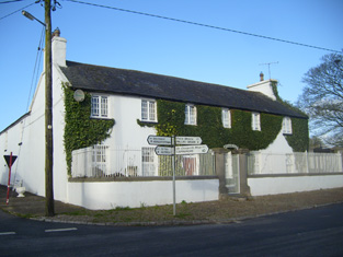
| Newtown House | In 1786 Wilson refers to Newtown as the seat of Mr. Ellard. Occupied by Miles Ryan in 1814 and by Richard Ellard at the time of Griffith's Valuation. Ellard held the property from - Keating and the buildings were valued at £13. Lewis refers to Newtown Ellard as the ancient seat of the Lloyd family. In 1906 this house valued at £23.10 shillings was occupied by Mary R. Ellard. It is still extant. |
|
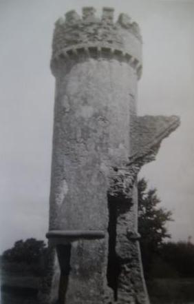
| Castle Lloyd | The seat of the Lloyd family in the 19th century, the sale rental of 1855 records that the original lease was from Robert Bradshaw to the Reverend Richard Lloyd, 8 Nov 1760. IN 1786 Wilson refers to Castle Lloyd as the seat of Rev. Mr. Lloyd. It was occupied by the Reverend Michael Foster in 1814 and by Thomas Lloyd in 1837. Although described by Lewis in 1837 as the handsome residence of Thomas Lloyd, the Ordnance Survey Field Name Book states that the house was in a neglected and decayed state in 1840 due to the death of "the Captain this year". By the time of Griffith's Valuation the house was leased to the Guardians of the Tipperary Union who were using it as a Workhouse. The buildings were valued at £44. Castle Lloyd was advertised for sale in November 1881 on 93 acres. It belonged to Patrick Daly who held it under a fee farm grant dated 12 July 1869 from Letitia Anne Bradshaw to William Daly. The Irish Tourist Association Survey of the early 1940s refers to the demolition of this house about 70 years previously and that only the circular tower remained of the extensive 18th century dwelling built by Captain Lloyd. |
|
| Milltown | In the 18th century Miltown was the residence of a branch of the De Lacy family. Mill-town, Bruff, was the residence of Mrs Bevan in 1814. George Gubbins was the occupier in 1837 and at the time of Griffith's Valuation. He held the property valued at £40+ from Edward B. Hartopp. In 1831 George Gubbins married Elizabeth Blood nee Hartopp. This house is named Milltown George on the first Ordnance Survey map. |

|
| Ballynacree House | A house valued at £10 and held from Samuel Dixon by Michael Manning in the mid 19th century. Ballynacree is still extant. |

|
| Cloverfield | In 1786 Wilson mentions a house called Cloverfield three miles beyond Caherconlish as the seat of Mr. Lloyd. A house named Cloverville is marked on the first edition Ordnance Survey map. On later maps a much larger building is marked. At the time of Griffith's Valuation valued at £9.5 shillings was vacant in this townland. Richard Laffan, a dairy farmer, is recorded as the immediate lessor. The National Inventory of Architectural Heritage dates the original building from circa 1830 with later 19th century additions. The house continues to be used as a residence. |

|
| Knockainy Cottage | Possibly located on the estate of the Earl of Kenmare who owned land in this parish in the mid 19th century. On the first edition Ordnance Survey map this building is named Knockainy Cottage. Later maps show a much larger building now known as Knockainy Stud. |

|
| Kildromin | In 1786 Wilson refers to "Kildrummond" as the seat of Mr. Lloyd. At the time of Griffith's Valuation, a house in Kildromin townland, valued at almost £4 was being leased by James Fitzgerald from the Apjohn estate. There is still a substantial farm at the site. |