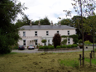
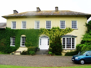
Suir Castle House
Houses within 5km of this house
Displaying 19 houses.
Houses within 5km of Suir Castle House
Displaying 19 houses.
| House name | Description | |
|---|---|---|
| Lismacue | The seat of the Baker family in the 18th and 19th centuries, Lismacue was referred to by Wilson as the seat of Mr. Baker in 1786. It was occupied by William Baker in 1814 and by his nephew, Hugh Baker in 1837 when Lewis describes the house as a "handsome castellated mansion". The Ordnance Survey Name Books describe it as "lately erected...the property of John Charters" in 1840. The house was valued at £55 at the time of Griffith's Valuation. This property is still in the possession of a family member and may be rented for country vacations. http://www.lismacue.com/index.htm |

|
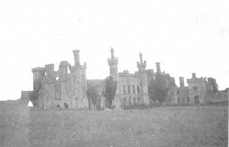
| Thomastown Castle | The original building was a two storey house of pink brick built in the 1670s by George Mathew with early 18th additions. Wilson decribed it in 1786 as "an ancient but handsome edifice". In the second decade of the 19th century it was enlarged and transformed into a Gothic castle, designed by Richard Morrison for the 2nd Earl of Llandaff. Viscount Chabot is recorded as the occupier in the mid 19th century. He held the property in fee and the buildings were valued at £100. Bence Jones writes that it later was in the possession of the Daly family but from the mid 1870s it began to decay. William Daly was the occupier in 1906 when the buildings were valued at £61. |
|
| Boytonrath | T. O'Meagher was the proprietor of Boytonrath in 1814. The Ordnance Survey Name Books refer to Richard Anderson as the occupant in 1840. In the early 1850s Henry Andrews was the occupier holding the property from the representatives of William Roe. The buildings were valued at £12+. A house and farm are still extant at the site. | |
| Belle Vue | Belle Vue house situated in Belle Vue Park in the townland of Boytonrath was occupied by Andrew Roe in 1814 and by George Roe in 1850. The buildings were valued at £9.15 shillings. The house has been altered over the years and is still the centre of a working farm. |
|
| Garranlea | A Keating home from the 18th century, occupied by Leonard Keating in the first half of the 19th century. In 1800 Leonard Keating married Lucinda Scully of Kilfeacle. Their son, Robert, was Member of Parliament for county Waterford in the late 1840s. In 1850 he held the property from the Earl of Clonmel and the buildings were valued at £34+. This house no longer exists. | |
| Bansha House | Bansha House is marked on the first edition Ordnance Survey Map circa 1840. It was the home of Robert Clarke, fourth son of the Reverend Marshal Clarke, in 1837. John Vincent occupied a house valued at £20 in this townland at the time of Griffith's Valuation. He held it from Richard Butler. The National Inventory of Architectural Heritage dates this house from about 1880. It now functions as a guest house. http://www.tipp.ie/banshahs.htm |

|
| Kilmoyler | A late 18th century house, the seat of the O'Meagher family, occupied by Dennis O'Meagher in 1814 and 1837 and by Stephen O'Meagher at the time of Griffith's Valuatiton. He held the property in fee and the buildings were valued at £40. In 1865 this property was advertised for sale by the Prestons. The rental records that the house was held on a lease dated 1860 from William O'Meagher to Standish Butler who was resident at the time. In 1786 Wilson had recorded "the castle and house at Kilmoyler, the ancient seat of Colonel Butler". Still extant and occupied. |

|
| Castlepark House/ Mantle Hill | In 1786 Wilson refers to the seat of Mr. Alleyn on the left at the entrance to Golden. He may be referring to the early house at this site, shown as Castlepark House on the first edition Ordnance Survey map. By the early nineteenth century it was the home of the Creagh family. Richard Creagh was resident in 1814 and 1837 and Lawrence Creagh held the property from Kingsmill Pennefather at the time of Griffith's Valuation. The buildings were valued at £65. Later bought by the Scullys, when it became known as Mantle Hill. Occupied by Vincent Scully in 1906. The house is no longer extant. |
|
| Ballycarron | The Butlers are described as "of Ballycarron" from the early 18th century. Ballycarron was the residence of Thomas Butler in the 19th century, held from Michael Gavin in the 1850s when the buildings were valued at £36. ''Burke's Irish Family Records'' states that the proceeds of the sale of the Ballycarron estate and the house itself were bequeathed "to the Church". This building is now divided into residential apartments. | |
| Suirville | This house was the home of Peter Smithwick in the early 19th century. Suirville was held by Richard Butler from Michael Gavin at the time of Griffith's Valuation and the house, valued at £10, was occupied by Miss Alice O'Connor. The sale rental of 1873 shows William Roche as tenant, trustee for Mr Butler. The Irish Tourist Association Survey records Suirville as the birthplace of Sir William Butler in 1838. The house was a ruin in the early 1940s. | |
| Ballyslatteen | Richard Butler, a younger brother of Thomas Butler of Ballycarron, was resident at Ballyslatteen in 1837 and at the time of Griffith's Valuation. He held the property from the Honourable John Massey and the buildings were valued at £20. Included in the sale of the Earl of Portarlington's estates in June 1856. A building is still located at this site. | |
| Hymenstown | This house was the home of the Robbins family in the 18th and 19th centuries. Occupied by George Robbins in 1814 and by R. Scully in 1837. Michael Cleary was resident at the time of Griffith's Valuation holding the property from Nathaniel E. Robbins, when the buildings were valued at £20. Included in the sale of the Earl of Portarlington's estates in June 1856. John Graham was living at Hymenstown in the 1870s. This house is still extant. |
|
| Athassel | James Scully was occupying this house at the time of Griffith's Valuation. He held it from Richard Creagh and the buildings were valued at £30. This house is still a residence. |
|
| Rathcloheen | Rathcloheen was the home of John Mathew in the first half of the 19th century. The house is situated very close to Thomastown Castle. At the time of Griffith's Valuation John Mathew held Rathcloheen from Lynn Carew and the buildings were valued at £20. "Burke's Irish Family Records" refers to John Smithwick of Rathclogheen, county Tipperary who married Cherry Pennefather in 1823. This house is well preserved and is still used as a residence. |

|
| Barnlough | This house was a Smithwick family home in the 18th and early part of the 19th centuries, occupied by Thomas Smythwick in 1814 and by P. Smithwick in 1837. Barnlough was held by the Earl of Portarlington in fee at the time of Griffith's Valuation, when the buildings were valued at £11.10 shillings. It is no longer extant. | |
| Drangan | In the mid 19th century Daniel Heffernan held buildings valued at £15 from the Earl of Lismore at Drangan Beg. Drangan House is marked on both the first and 25-inch edition Ordnance Survey maps. A house and large farm are now located at the site. | |
| Athasselabbey | A house occupied by William Dalton and held from Francis Green in the mid 19th century. The house was valued at £12+. It is still occupied. |

|
| Ballymorris | In 1786 Wilson refers to Ballymorris as the seat of Mr. Magher. By the time of Griffith's Valuation the townland was held by Stephen O'Meagher and the buildings were valued at £1. The house appears to be gone by the time the first Ordnance Survey map was published as it is not shown there. | |
| Hymenstown House | Hymenstown House is shown on the 25-inch Ordnance Survey map of the 1890s. The National Inventory of Architectural Heritage suggests it was built sometime in the 1860s. The house on the site at the time of Griffith's Valuation was owned by Nathaniel Robbins and valued at under £2. In 1901 it appears to have been the property of Alex Going but was vacant at the time. Hymenstown House is still extant and occupied. |
|