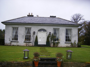
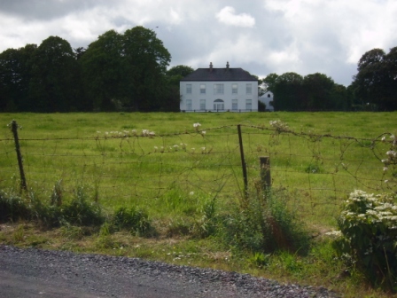
Lisduane
Houses within 10km of this house
Displaying 48 houses.
Houses within 10km of Lisduane
Displaying 48 houses.
| House name | Description | |
|---|---|---|
| Odell Ville | This house was occupied by John Odell in the early 1850s and held by him in fee. It was valued at almost £14. The house was the residence of William Odell in the 1870s. Home of the Morony and Lloyd families in the late 19th and 20th centuries. Occupied by Wilfrid H. Wilkinson in 1906. It was advertised for sale in February 2009. |

|
| Fort William House | Fort William was the residence of a branch of the Odell family in the 18th century. Occupied by Reverend John Graves in 1814. Mrs Graves had a flour mill here in 1837 but T. O'Dell was living at Fort William. The Ordnance Survey Name Book states that this house was formerly the residence of William Brown of Springmount ''at present occupied by a herdsman''. The residence of Richard D. Power in the mid 19th century who held the property valued at £11 from John B. Graves (in Chancery). The home of Goodricke Thomas Peacocke in the 1880s. This house is still extant and occupied. |
|
| Springmount | Richard S. Croker was the proprietor of this townland at the time of the first Ordnance Survey and Springmount was the residence of William Brown. By the time of Griffith's Valuation Gerard Barry held the house and 56 acres in fee. | |
| Drombeg | A house located on the estate of the Earl of Sandwich at the time of Griffith's Valuation and occupied by John Mulcahy, when it was valued at £11. [Grid reference is approximate]. | |
| Ballynoe | An 18th century house built by the Cox family. This house valued at £39 was the home of William Cox in the 1850s and 1870s. At the time of Griffith's Valuation it was held from the Court of Chancery. Bence Jones records this house as now derelict. Described as the Irish Tourist Association surveyor in 1944 as a "grand" Georgian house but in a very bad state of repair. |

|
| Ballyknockane | The home of the Scanlan family from at least 1814 when Michael Scanlan was resident. Occupied by William Scanlan at the time of Griffith's Valuation, held by him in fee and valued at £25+. In 1906 William Scanlan held 145 acres of untenanted land and a mansion valued at £22 at Ballyknockane. Residence of Miss Reynolds in 1944. | |
| Ballynahaha | The residence of Mathew Scanlan circa 1840. Located on the Scanlan estate in the mid 19th century, occupied by David Bennett and valued at £11. | |
| Liskennet | Nicholas Monckton of Liskennet made his will in 1721. Patrick Heffernan lived at Liskennet in 1814 and Roger Sheehy circa 1840. In the 1850s the house was ccupied by Francis S. Walker, valued at £15+ and held from John Anster, Trinity College Dublin and Ellen Heffernan. The sale rental of the Walker/Anster estate in 1873 refers to Lots 1 and 2 as formerly part of the estate of Michael Heffernan of Camas. By the 1870s Liskennet was in the possession of the Conyers family. The old stable block is still extant but the house is a modern structure. |
|
| Garrane | A house located on the Wyse Minors estate in the mid 19th century, occupied by Margaret Hartigan and valued at £11+. This house is barely marked on the first Ordnance Survey map. | |
| Fort House | The residence of David Hartigan in the early 1850s, held from William and Charles Wyse (minors) and valued at £13. | |
| Drewscourt | Home of the Drew family in the 18th and early 19th century. Drew's Lodge, Charleville, is listed as the residence of F. Drew in 1814 and Lewis refers to Drew's Court as the residence of the Drew family. The house appears to be vacant at the time of Griffith's Valuation and was in the possession of Henry Thomas Allen who held land from Francis Drew. Clennel Frank Massy Drew occupied this house in 1906, valued at £18. Drewscourt was burnt down in the 1920s but the farmyard complex remains. |
|
| Rossmore | Rossmore was the home of the Shelton family in the 18th and 19th centuries, occupied by J. Shelton in 1814 and 1837. The Reverend Grantley Shelton was resident in the early 1850s. The house was held from the Conyers family and was valued at £25. In 1894 Slater refers to it as the residence of Deane Shelton. | |
| Ballynakill | A house on the Pigott estate, burnt by the insurgents on 24 February 1822 according to Fitzgerald as it had been converted into a soldiers' barrack. It was occupied by Richard Pierce Power in the early 1850s and valued at £14. |

|
| Heathfield House | Located on the Warren estate this house was occupied by Edward Lloyd circa 1840 and in the early 1850s who held it along with 609 acres. Still in Lloyd occupation in the 1970s. This house was offered for sale in 2010. | |
| Bruree Lodge | Bruree was the home of the Langton family in the 18th century. The house was occupied by Michael Ryan at the time of Griffith's Valuation and held from Michael Shaughnessy, it was valued at £13+. |
|
| Frankfort | Samuel Adams was living at Frankford, Newcastle, in 1814. The residence of Richard Standish circa 1840 and of John White who held it in fee in the early 1850s. The buildings were valued at £9. This house is still well maintained and occupied. | |
| Kilmore | Brian de Breffny writes that the back section of Kilmore House is part of the 17th century house built by the Moncktons. The front part was built by the Tuthills in the mid 18th century. George Tuthill purchased the house from Edward Monckton in 1737. The Tuthills had previously held it on lease. Occupied by Thomas Lynch in 1814 and by Colonel William Jones in the early 1850s, when the property was held from Elizabeth Tuthill and valued at £15. In 1906 Kilmore was the residence of Anne Isabel O'Grady. This house is still extant and occupied. |
|
| Ballyneale | Bence Jones writes of this house having an early 19th century appearance. Occupied by John Cox and held from the Honourable John Massy in the early 1850s. The buildings were valued at £13+. At the end of the 20th century this house was the home of Lewis Glucksman. Sold by the Glucksmans in 1998. In 2008 it was placed on the market again by its current owner David Pearl for 10,000,000 euro. see http://www.michaelhdaniels.com/index.cfm?fuseaction=propdetails&Prop_RefId=39 |

|
| Glenwilliam | A house built in 1797 by the Reverend William Massy, second son of the Reverend Godfrey Massy. Occupied by George Massy in 1814. The residence of Mary Anne Massy at the time of Griffith's Valuation, held from the Court of Chancery and valued at £38. In the later 19th century it was the home of the Atkinson family. Slater noted it as the seat of Thomas D. Atkinson in 1894. This house is still extant and occupied. |

|
| Kilbeg Lodge | The seat of John Scanlan circa 1840 and of Sarah Scanlan in the early 1850s, held from William Scanlan and valued at £14. In 1906 occupied by William Scanlan and valued at £10. | |
| Coolrus House | The residence of Richard Harte circa 1840 and of James Lynch in the early 1850s who held the property and 186 acres from the Court of Chancery. The house has diminished in size by the publication of the 25-inch edition Ordnance Survey map in the 1890s and it is no longer extant. | |
| Castletown Conyers | The seat of the Conyers family, occupied by C. Conyers in the early 19th century. By the time of Griffith's Valuation the house appears to be in use as an auxiliary workhouse, held by the Croom Guardians from William Bailey, medical doctor, and valued at £25. In 1894 it was the residence of Charles Conyers. |
|
| Bruree House | Bruree House was also located on the Langton estate although at the time of the first Ordnance Survey the property was in the hands of Robert Fetherston who held a number of townlands in the parish, possibly from the Langtons. At the time of Griffith's Valuation the house was in use as an auxiliary workhouse. In 1853 Bruree House was sold to a member of the Shelton family and in 1868 it was sold to John Gubbins of the Kilfrush family. He was a successful racehorse owner and in 1884 built the present Bruree House. When he died in 1906 the property passed to his nephew John Norris Browning. The house was valued at £92 at this time. Owned by the Sheehans and Vernons in the 20th century. Now function as as a rehabilitation centre, known as Cuan Mhuire. A print entitled "The Lawn Meet" by Patrick Hennessy depicts this house. See www.museum.limerick.ie |

|
| Kilmurry | A house valued at £11 and held by Eyre Lloyd in fee at the time of Griffith's Valuation, now derelict. |
|
| Castle Ievers | The Ievers were living at Castle Ievers, originally known as Tullerboy, from the mid 18th century. Bence Jones dates this house from the early 19th century. Robert Ivers was resident in 1814, 1837 and at the time of Griffith's Valuation when the buildings were valued at £32. The property was held from William Maunsell. The Irish Tourist Association surveyor wrote in 1943 that much of Tullerboy Castle was demolished in the 1860s to make way for the present building. The owner in the 1940s was Roderic Haines. |

|
| Coolboy | A herd's house and offices situated on the St Leger estate was occupied by Henry Ievers at the time of Griffith's Valuation when the buildings were valued at £14+. Coolboy was occupied by the representatives of Robert Cleary in 1906. A substantial farm is still extant at the site. | |
| Cooleen | At the time of Griffith's Valuation William Hart Mason held the townland of Cooleen amounting to 88 acres in fee. The buildings were valued at £12. |
|
| Cherrygrove | Cherrygrove was the home of Edward Cripps in 1814 and of J. Barry in 1837. At the time of Griffith's Valuation it was occupied by Edward John Sheehy who held the property from Robert Harding. The buildings were valued at £21+. The Misses Sheedy were still in residence in the 1940s. A building is still extant at the site. | |
| Belview/Bellevue | A home of the Yielding family, occupied by Richard M. Yielding in 1814 and 1837 and by Timothy Hartigan who held the property from James Barry at the time of Griffith's Valuation. The buildings were valued at £13 at that time. Bought by the Delmeges in the early 1850s. The original house is not extant. | |
| Carass Court | ''Burke's Irish Family Records'' states that Jeffrey Browning purchased Carass Court, from Lord Carbery. Leet records Jeffrey Browning as the proprietor of Carass Park in 1814. Jeffrey/Geoffrey Browning was married to Frances, sister of Sir David Roche, 1st Baronet. By the time of Griffith's Valuation Thomas Wise Browning was the occupier and he held the property, valued at £50, from Sir David Roche. The Brownings were still resident at Carass Court in the 1940s but the house was later demolished. |
|
| Clorane | A house occupied by Henry Hunt in 1814. Lewis describes Clorane as a "fine old house belonging to the Hunt family". By the time of Griffith's Valuation Edward Browning was leasing the house and 280 acres from Sir David Roche. In the 1870s in the possession of Patrick Hartigan. Old farm buildings are still located at the site but the house is a modern structure. |

|
| Croom House | Croom House was the home of the Lyons family in the 18th and 19th centuries. The house of James D. Lyons was valued at £48 in the early 1850s and he had a flour mill valued at £75 closeby. He held the property from John Croker. Described in 1943 by the Irish Tourist Association surveyor as a beautiful mansion on the left bank of the Maigue river, it was then in use as a military post. The house is still extant and occupied. |

|
| Islandmore | Tooreen, located just south of the town of Croom, was the residence of James D. Lyons in 1814 and 1837. By the early 1850s this house, then known as Islandmore, was occupied by Robert Maxwell, valued at £60 and held from Miss Catherine Giles. It later became the home of the Kelly family and Slater refers to it as the seat of John Roche-Kelly in 1894. Colonel Basil Roche Kelly was resident at the time of the Irish Tourist Association survey of 1943. The surveyor wrote that the house was originally Georgian but had suffered many alterations. |
|
| Croom Castle | Originally a Fitzgerald Castle, subsequently granted to the Duke of Richmond who sold it to John Croker in 1721. Reverend Fitzgerald writes that Croker was agent to the Duke. A residence was built with some of the stone from the old castle. Situated on the outskirts of the town of Croom this house was occupied by Samuel A. Dickson in the mid 19th century who held it from the Crokers. The buildings were valued at £30. Sold in the late 1880s to the Lyons family and bought by Michael Corry in 1936. Now functions as self catering accommodation. see http://www.croomcastle.com/history.html |

|
| Glenbevan | Lewis records J. Bevan as the proprietor of Glen-Bevan in 1837 and Joseph Bevan occupied the house and 173 acres at the time of Griffith's Valuation. The property was located on the Evans estate. The residence of Mr John Hedderman in 1943, this house is still extant and occupied. |

|
| Clogher West | A house occupied by John Fitzgerald and held from George Whitelock at the time of Griffith's Valuation. The buildings were valued at £12. The original house does not appear to be extant. | |
| Creggane Castle | A property associated with the Hutchins family, occupied by John Quaid at the time of Griffith's Valuation and held from Samuel Hutchins. The buildings were valued at £17. The sale rental 1857 records that the original lease dated 1802 was from Edmund Earl of Cork and Orrery to Emanuel Hutchins. Farm buildings occupy the site. | |
| Dunnaman | Matthew O'Flaherty held buildings valued at £13+ and 219 acres from James D. Lyons at the time of Griffith's Valuation. Grid Reference is approximate. | |
| Carrigeen | John Christy held a house valued at £21 and 513 acres at Carrigeen from the Earl of Dunraven at the time of Griffith's Valuation. A modern farm is extant at the site now. | |
| Dollas Upper | Mary Blake occupied a house valued at £12+ and 48 acres on the Langford estate at the time of Griffith's Valuation. This property is labelled Dollas House on the Ordnance Survey map published in 1942. Unroofed buildings are still extant at the site. | |
| Grove House | This house appears to straddle the boundary of the parishes of Ballingarry and Rathkeale and the border of the baronies of Connello Upper and Lower. Occupied by Colonel William O'Dell Member of Parliament in 1814 and by Major O'Dell in 1837. By the time of Griffith's Valuation Major O'Dell's estate at Rylanes was in Chancery and Grove House was in use as an Auxiliary Workhouse. It was valued at £35 and held by the Croom Guardians from Robert Maxwell. This house is no longer extant but substanial yard buildings remain. |

|
| The Turret | Lewis writes that the Turret was erected by a branch of the De Lacy family and repaired by Colonel O’Dell in 1683 and was "lately the residence of Major O’Dell". The Ordnance Survey Name Books refer to an inscription on the wall of the building which recorded the O'Dell family inhabiting the building in 1683. It was reputed to incorporate a turret from an old house of the Knights Hospitallers. Thomas O'Dell was resident in 1814 and Mrs O'Dell of the Turret, Ballingarry, died in 1818 according to the church records of that parish. Fitzgerald in 1826 refers to Jackson's Turret, built on a hill and "now nearly in ruins". Bence Jones writes that a porch and wing were added to the building in the late 19th century and that it became a presbytery. Grid reference is approximate. | |
| Harding Grove | Occupied by G. Harding in 1814 and H. Harding in 1837. The seat of Mr Harding at the time of the first Ordnance Survey. By the time of Griffith's Valuation a Neill McDonald was in possession of Harding Grove. Neil Macdonald of Steyle Park, Bruree owned 354 acres in county Limerick in the 1870s. Francis H. Wyse is recorded as the occupant of Harding Grove in 1906. |

|
| Cappanihane | This house was occupied by John Mason in 1814, by R. Mason in 1837 and in use as an auxiliary workhouse at the time of Griffith's Valuation, when the buildings were valued at £15. This house was the home of John Parker Graham in the 1860s and 1870s. Another house in this townland, Glenbrook Lodge, was occupied in the early 1850s by Myles Mason and valued at £9+, grid reference R492 318. Mary Hamilton held a mansion house valued at £20 and 41 acres of untenanted land at Cappanihane in 1906. | |
| Athlacca House | A residence of the Ormsby family in the 18th century. On the first Ordnance Survey map the house is marked "in ruins". Also known as Old Court. | |
| Ashborough | Lewis records Daniel D. Power as resident at Ash Grove in the parish of Ballingarry in 1837. Held Daniel D. Power at the time of Griffith's Valuation and valued at £16 and in his occupation at the time of the 1854 sale. An old outbuilding remains at the location of this house. |
|
| Ballyteige | Originally the home of a branch of the Tuthill family, no large house is marked on the first Ordnance Survey map in this townland. The house was leased to David Conyers of Castletown Conyers in 1885 and to Thomas W. Westropp Bennett in the 1890s. It is now available for hire, see http://www.ballyteigue.com/ |
|
| Gortskagh | No house of more than £5 valuation is recorded in Griffith's Valuation in Gortskagh except the glebe house at £26. This house was occupied by Reverend William Bunbury who held the property from John Courtenay. The Deane connection with Gortskagh commenced with the marriage in 1871 of Honourable Matthew J.H.F. Deane, uncle of the 4th Baron Muskerry, with Maria, daughter of Reverend William Bunbury. The Deanes sold the house to the Binchy family in the 1890s. Home of the Foley family in the early 21st century. |
|