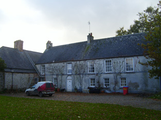
Ballysteen
Houses within 10km of this house
Displaying 40 houses.
Houses within 10km of Ballysteen
Displaying 40 houses.
| House name | Description | |
|---|---|---|
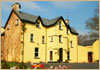
| Carrigerry | Built in the late 18th century, this house was occupied by John O'Halloran in 1814 and by Major Creagh in 1837. Mary Creagh, who held the property from Francis Macnamara was in residence in the mid 1850s. The house is now a country hotel run by Mr and Mrs N. Ennis see http://www.carrygerryhouse.com/index.html |
|
| Lismoyle | This house dates from circa 1841 when it was the residence of T. O'Donoghue. At the time of Griffith's Valuation it was the home of Patrick O'Donoghue who held the property from Mary O'Grady. Occasionly used as a shooting lodge by the O'Grady family and it remained in their possession until the 20th century. | |
| Ballymurtagh | A house on the Miller estate, leased to John Kelly in the mid 19th century, when it was valued at £12. Weir writes that it was demolished due to its proximity to Shannon Airport runway. | |
| Stonehall | The home of the O'Briens, later Stafford O'Briens, at the beginning of the 18th century and later in the possession of the Fitzgeralds. By the beginning of the 19th century the house was in the hands of the McMahon family. At the time of Griffith's Valuation James McMahon was leasing Stonehall from the Stafford O'Briens, it was valued at less than £3. Later the home of the Whites who intermarried with the McMahons. It is no longer extant. | |
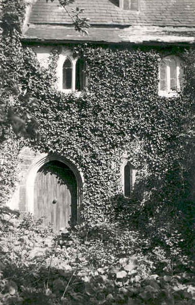
| Paradise | This was originally a 17th century house situated almost on the shore of the Shannon. In 1786 Wilson refers to it as "Paradise, the delightful seat of Mr. Henn, finely situated on the side of a high hill". It was altered in the 19th century. Many members of the Henn family were involved in the legal profession and lived in Dublin so the family did not inhabit the house much until the second half of the 19th century. In 1814 John Scott was residing in the house and Thomas Arthur in 1837. In the mid 1850s the house was unoccupied and Augustus Arthur was the immediate lessor. It was valued at over £17. The Henns began to reside soon afterwards. IN 1894 Slater refers to Paradise as the seat of Judge Henn. The Irish Tourist Association Survey File of the 1940s refers to rumours of the Colonel's intention to sell Paradise. Destroyed by fire in 1970. |

|
| Crovraghan | A house situated on the Wyndham estate, occupied by John Tatlow in 1814 and J. O'Donnell in 1837. James O'Donnell held the house, valued at just over £10, from Colonel George Wyndham at the time of Griffith's Valuation. Later the home of the Cannon family until the 1970s. |
|
| Shore House | The O'Gradys lived at Shore House from at least the 1820s. Jane O'Grady held the house from John Bindon Scott at the time of Griffith's Valuation, when it was valued at £14.10 shillings. Jane O'Grady married Daniel O'Connell of Kilgory. The home of the Hogan family at the end of the 20th century. |
|
| Fort Anne | The residence of S. E. Johnson in 1837, built by his father William. The house was occupied by Richard Johnston in the early 1850s who held the it from the Reverend R. Dickson, who held the demesne in fee. In 1906 this house valued at £13.15 shillings was occupied by William D. Dickson. The original house is no longer extant. | |
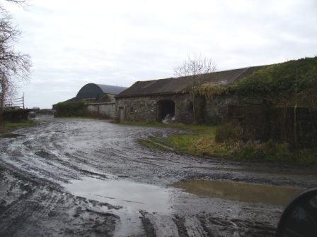
| Movena | A house on the Roche estate occupied by Bridget Farrell in the early 1850s when the buildings were valued at £11. Movena is marked on the first edition Ordnance Survey map. It is now a ruin. |
|
| Corgrig House | Gerald Griffin was the proprietor of Corgrig in 1826, Mrs Griffin occupied Congrieff in 1837 and Gerald Griffin held Corgrig from Lord Monteagle in the early 1850s. The Ordnance Field Name Books state that Peter Griffin was the proprietor circa 1840 and that his father had erected this house about 80 years previously. It is still extant though with modern housing now occupying much of the surrounding area. The 25-inch Ordnance Survey map of the 1890s also shows a house known as Corgrig Lodge in the same townland at R253511. | |
| Old Abbey | The home of the Greene family for most of the 18th century. In 1786 Wilson refers to "Abbey" as the seat of Mr. Greene. Subsequent tenants were the Hodges and the Morgans. The Ordnance Field Name Books state that part of the building was very ancient and that a new front had been built in 1805. George Morgan was resident in 1814, William Morgan in 1837 and in the early 1850s, when he held the property from the Earl of Cork. Old Abbey passed to Willliam's daughter, Mrs Wardell, and stayed in the possession of the Wardell family into the 20th century. It is no longer extant. |
|
| Farm Lodge | Marked as Farm Lodge on the first Ordnance Survey map this house on the De Vere estate was occupied by James Potter in the early 1850s when it was valued at £16. An extensive farm still exists at the site. | |
| Cartown | Built in 1763 Cartown was the residence of Mr Baldwin in 1826 and of John Edward Langford in 1837. In the early 1850s Griffith's Valuation records the vacant house as valued at £24, William Sheedy holding the whole townland from General James Caulfeild. By the late 19th century the house was in the possession of the Westropp family. This house is still extant and occupied. |
|
| Mount Pleasant | The Ordnance Survey Name Books record that this house was built in the mid 18th century by a Mr Star. It was a neat farm house occupied by Mrs Hill in 1837 and by Thomas Hill at the time of Griffith's Valuation. He held the property from Daniel Leahy and the buildings were valued at over £11. This house is still extant and occupied. |
|
| Shannon Grove | Originally the home of the Bury family, Earls of Charleville, overlooking the Shannon estuary. The Ordnance Survey Name Books record this house as four-storied, built in 1709. Bence Jones dates this house from the early 18th century. Lewis writes that Shannon Grove was the old family mansion of the Earls of Charleville and "now the residence of Bolton Waller". Bolton Waller held the property in fee in the early 1850s when the buildings were valued at £43 and the demesne was over 400 acres. Bought by John Sheehy of Askeaton in 1860 and remained in the possession of his descendants until the mid 20th century. The house is still extant and occupied. |
|
| Castletown | The main residence of the Waller family in the 18th and 19th centuries, now demolished. The house was valued at £80 in the early 1850s when it was the residence of the Reverend William Waller. By 1906 its value was reduced to £72.5 shillings and it was occupied by the Reverend John Thomas Waller who was also resident in 1894. The surveyor for the Irish Tourist Association Survey in 1944 refers to the house being recently levelled to the ground. | |
| Bushyisland | This house was the residence of Peter Lowe in 1814 and in 1837. John Peppard MD was the occupier at the time of the first Ordnance Survey and of Griffith's Valuation. He held the property from Bolton Waller and had converted the house into an asylum. | |
| Kilbreedy | A house occupied by Michael Nash at the time of Griffith's Valuation and held from the Reverend William Waller, valued at £11. | |
| Stonehall | A house built c.1803 and situated on the Waller estate. It was occupied by the Langford family from at least the early 19th century. At the time of Griffiths Valuation, it was leased by Edward Langford from William Waller, when it had a valuation of £11. It appears to have been occupied by Robert Smyth in the early 20th century. This house is still extant and occupied. |

|
| Copsewood | Copsewood Cottage is marked on the first Ordnance Survey map at this site. A much larger house was built in the mid 19th century for Major General Caulfeild. It was valued at £36 at the time of Griffith's Valuation and at £63 in 1906. It remained in the possession of the General's descendants until 1919 when it was bought by the Salesian Fathers who started an agricultural school. It is now a secondary school run by the Salesian Order. |
|
| Summerville | Described by Lewis as an ancient seat of Lord Charleville "now occupied by an agent". In the early 1850s Patrick and Michael O'Donnell were resident and they held the property from General James Caulfeild. | |
| Glenagaureen | The Ordnance Survey Field Name Books circa 1840 record an unoccupied house named Glenagordon in Ballysteen, built 1826 by Edmund Odell Westropp. A vacant house valued at £16 and held by Edmund Westropp was recorded in Griffith's Valuation for Ballysteen. | |
| Milltown | The Reverend Champagne was resident at Milltown from at least 1837. He is recorded as the occupier of this house in the early 1850s when he held the house valued at £28 from the Reverend Tyrell Evans. | |
| Holly Park | In 1786 Wilson describes Holly Park as "the seat of Richard Taylor, it is very commodious and well-situated, having convenient offices and extensive demesnes". Lewis writes that Holly Park was the ancient residence of the Taylor family "now the property of Sir Aubrey de Vere". However Griffith's Valuation records Richard Taylor holding Holly Park in the early 1850s in fee. It was valued at £36. In 1894, Slater referred to it as the seat of George Taylor and in 1906 George Taylor held 277 acres of untenanted land and a mansion house valued at £34 at Currahchase North. Sold by the Taylors in 1939. Feheney writes that the son of Tom Clarke, one of the leaders executed in 1916, bought Holly Park from the Land Commission in the 1940s. The home of John Philip Cohane in the 1970s who had restored the house after a fire. It is still extant. | |
| Ballynolan | This 3 storied house was the seat of the Reverend Thomas Westropp, rector of Ardcanny, built by him [his father?] in 1797. It was occupied by H. Potter esquire in 1837 and by Peter W. Morgan at the time of Griffith's Valuation who held it in fee with a demesne of 98 acres. Valued at £11.10 shillings in 1906 and occupied by Sarah E. M. Westropp. Still extant and occupied. |
|
| Ballynacourty | A house occupied by Thomas Davenport from at least 1837. The Ordnance Survey Field Name Books circa 1840 state that the house was built by John Evans "about 90 years" previously. It was two storeys high. The house was valued at £15 in the early 1850s and was held from Daniel D. Power. The house is still extant and now owned by John Feheney. For more information see www.iverusresearchfoundation.com (See ‘Research Notes’, Ballinacourty House). |
|
| Bolane | Bollane Cottage was occupied by Arundel Hill in 1837. A house at Bolane was the residence of Thomas Hanly in the early 1850s and valued at £16. It was held from Daniel D. Power. A house is still extant at this location and occupied. |
|
| Castlegrey | A house in the possession of the Langford family in the 19th century, the residence of G. Langford in 1837 and of Charles Wiedenham Fosbery in the early 1840s and 1850s. He held the property from Mrs Jane Langford. It was valued at £11. Slater refers to it as the seat of Captain Frederick Verschoyle in 1894. Some buildings are still extant at the site. | |
| Castle Hewson | The seat of the Hewson family of county Limerick. William Hewson was in residence at the time of Griffith's Valuation when the buildings were valued at £23. Castle Hewson is no longer occupied but William Hewson, a descendant of George Hewson, resides in a building closeby and is restoring the property. A tower house stands beside the house. |

|
| Altavilla | Bence Jones writes that this house was built by the Bateman family in the mid 18th century to the design of Francis Bindon. In 1786 Wlson refers to it as the seat of Jon Bateman. The Ordnance Survey Name Book records that Altaville House was a rectangular building of four storeys built in 1749 by Mr Bateman and that it was then [circa 1840] undergoing repairs by Peter Griffin of Corgrieff. At the time of Griffith's Valuation it was inhabited by Peter Griffin who had carding mills and offices closeby. He held the property from William Dickson. It is still extant. |

|
| Ballycullen House | This house was built in 1740 by Carrol Naish on the foundation of Ballycullen Castle according to the Ordnance Survey Name Book. Occupied by Patrick C. Nash in 1814 and by Carroll Nash at the time of Griffith's Valuation, it was held from Henry Hare and valued at £14. It is still extant and was restored during the twentieth century. | |
| Morgans North | The Rose family were resident here in the early 18th century. Later a residence of the Sandes family of Queen's county, occupied by William Sands at the time of Griffith's Valuation who held the property from Charles L. Sands. The buildings were valued at £15+. This house was also known as Mount Pleasant, Lewis records Mrs Morgan as the resident in 1837. Hone of the O'Dells in the early 20th century and later bought by the Keane family. |
|
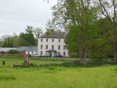
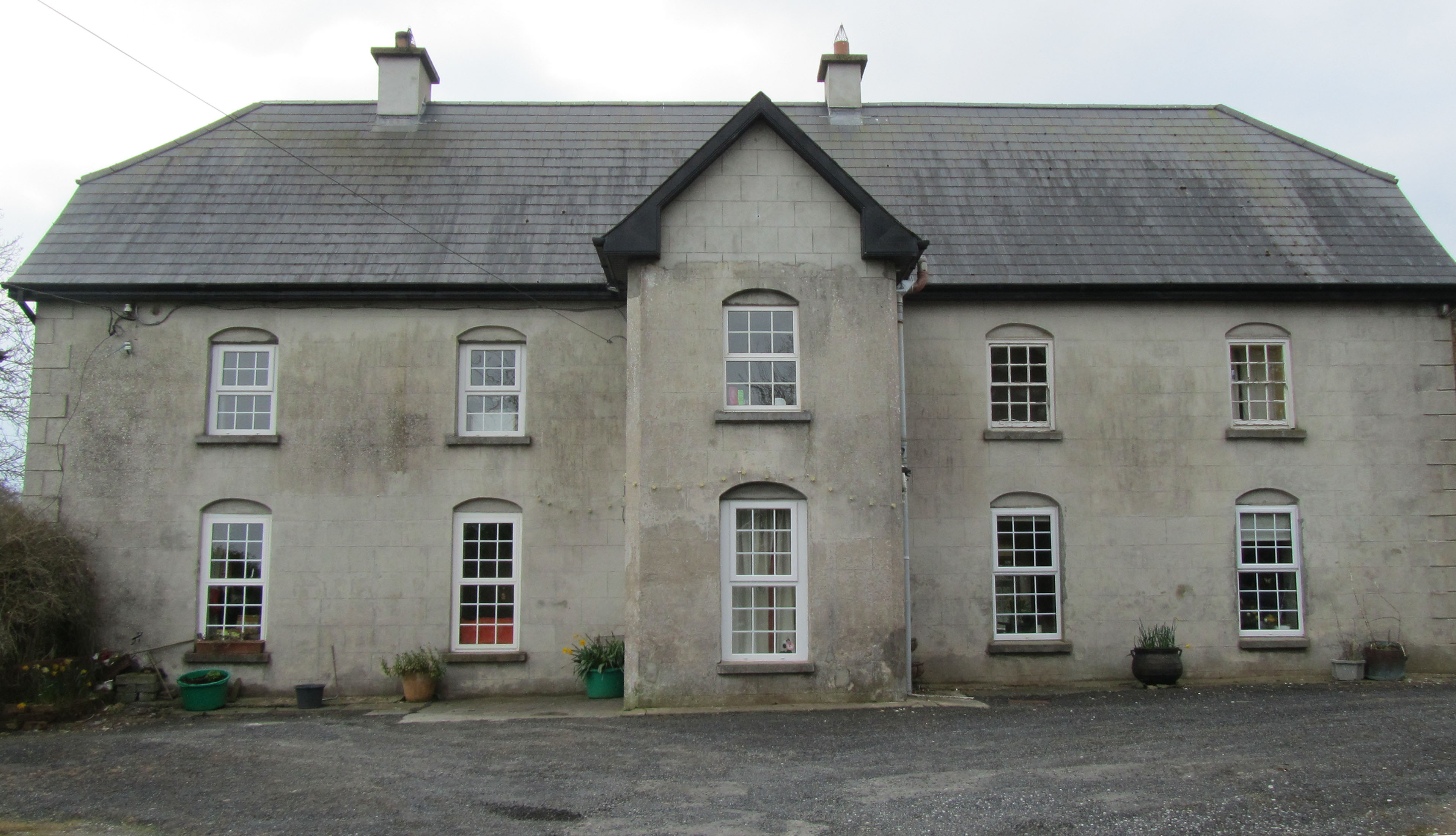
| Ballinvirick | The residence of the Royse family, held in fee by Thomas Royse at the time of Griffith's Valuation and valued at £15. Earlier in the 1830s Lewis writes of the great improvements which were in progress at Ballinvirick, Thomas Royse proprietor. In 1906 the house was occupied by Frances and Isabella Royse. Sold by the Royse family in 1919, it became a dowager house for Castle Hewson in the 1920s. The house has had a number of different owners in the 20th centuries and is still a family home. It is open to the public for two months of the year, see www.ballinvirick.ie/ |

|
| Nantinan House | Bence Jones writes that this was a mid 19th century house of the villa type. The original Nantenan was the residence of Major Wilson in 1814. In 1786 Wilson refers to it as the seat of Mr. Royse. It was renovated by Thomas H. Royse in the 1830s. The Ordnance Survey Name Book [circa 1840] states that the house was built about 100 years previously and that the family arms were cut over the hall door. Lewis writes of ''the very interesting improvements'' which ''have been made at great expense'' by T. H. Royse. This Royse residence was valued at £30 at the time of Griffith's Valuation and was held by Thomas Royse in fee. Advertised for sale in 1853 the house and 145 acres were purchased by John White for £3,800. He demolished the old house and built a new one in the late 1850s, which was still in the possession of the White family in the 20th century. In 1906 this house was valued at £48. In 1944 the author Dorothea Conyers is recorded as the owner (ITA). |

|
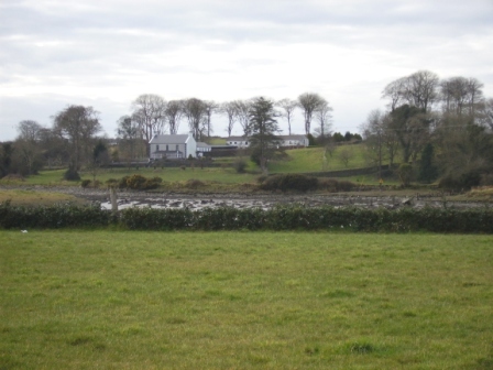
| Ballyclogh | A house on the Monteagle estate, leased to John Copley for ever. The house was 3 storeys high and had been repaired in 1810 by Copley. His representatives were subletting the house to Patrick Griffin by the time of Griffith's Valuation when the buildings were valued at £32. This house is now a ruin. |

|
| Ballynort | A Taylor residence which passed by marriage to the Massy family. In1786 Wilson describes it as" the pleasant seat of Mr. Massey". The townland of Ballynort, 657 acres, was held in fee by Standish O'Grady and E.T. Massy at the time of Griffith's Valuation. This house is marked "in ruins" on the first Ordnance Survey map. The buildings were valued at £4+. There is no trace of the house on the 25-inch Ordnance Survey map of the 1890s. | |
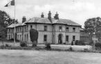
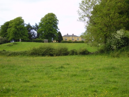
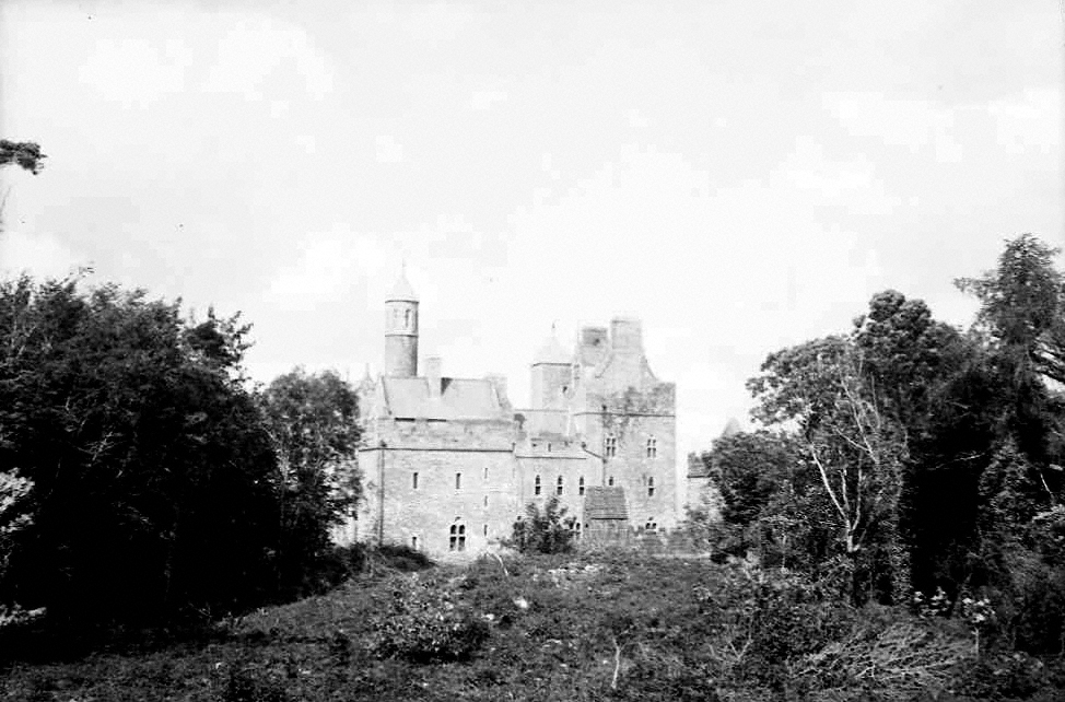
| Dromore Castle | In 1868 the building of Dromore Castle began. It was an elaborate country retreat for the 3rd Earl of Limerick designed by Edward William Godwin. In 1906 this mansion house was valued at £75.10 shillings. The 4th Earl of Limerick did not visit Ireland very much and the castle was sold in 1939. In 1944 the Irish Tourist Association surveyor refers to the castle as the property of Mr M.McMahon, a timber merchant of Limerick, who bought the property in 1941 for a reputed £8,000. By the mid 20th century it had fallen into disrepair and the roof was taken off. Plans to develop the site and to demolish the ruin are current issues discusssed in the local and national press. |
|
| Inchirourke More | The residence of Hunt Esq in the 1770s and in 1786. Occupied by Edward Hunt in 1814. At the time of Griffith's Valuation, Robert Hunt held the house, valued at £6.5 shillings, and over 500 acres in the townland of Askeaton from Sir Matthew Blakiston. It is still extant. |

|
| Betty Ville House | This house is marked on the first edition Ordnance Survey map. Located on the Blakiston estate, it was occupied by John Shaughnessy in the mid 19th century and held from the Messrs Young. It was valued at £5. |

|
| Foynes House | In 1837 Lewis describes a house on Foynes Island as a "handsome marine villa, the summer residence of the Earl of Dunraven". The 1st edition Ordnance Survey map shows a house named Foynes House on the southern part of the island. By the time of Griffith's Valuation this is in possession of Peter Griffin, leasing from the Spring-Rice estate and with a valuation of £1 15s. The later 25-inch Ordnance Survey map shows a much smaller property labelled Burneen, close to the site of Foynes House. This latter property is still extant. |