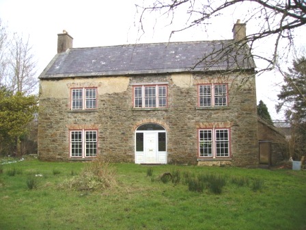
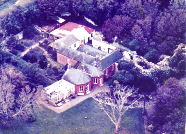
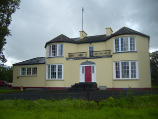
Pyrmont House
Houses within 15km of this house
Displaying 57 houses.
Houses within 15km of Pyrmont House
Displaying 57 houses.
| House name | Description | |
|---|---|---|
| Ballyartney | A house built by the Quaker family Barclay in the 18th century and their home in the 18th and 19th centuries. In 1786 Wilson mentions Ballyartney as the seat of Mr. Barclay. The house was occupied by Charlotte Barclay at the time of Griffith's Valuation but she held it from the Court of Chancery. Home of the O'Dea family in the 20th century. Unoccupied in 2009. |
|
| Gower Hall | A house on the Burton estate held by Francis Keane from Henry S. Burton at the time of Griffith's Valuation and valued at £12. It had previously being occupied by James Lillis in 1814 and also by Richard Pilkington who married Maria Blood of Applevale in 1805. Previously, in 1786, Wilson refers to Gower as the seat of Mr. Ames, "situated on a hill". The house was reconstructed in the late 19th century and is still a family home, the centre of a dairying enterprise. |

|
| Mount Pleasant | An 18th century house that was the home of Richard Bury, son of John Bury of Shannon Grove, county Limerick. In the 19th century it was the residence of the Cox family. Griffith's Valuation shows that Captain J. Cox held the property from the representatives of Anthony Hickman. The house was valued at £22. Two other houses in the townland of Clarefield were also occupied by members of the Cox family, Kate Ville and Mary Ville. This house is now a ruin. |
|
| Ballykett | Home of a branch of the Hickman family in the 18th century. Weir writes that the Tymons lived here at the end of the 18th century. Occupied by Thomas Pilkington in 1814 and later by the O'Donnell family and then the Brews. No house is named on the first Ordnance Survey map of 1842. George Brew held a house valued at 2 shillings at the time of Griffith's Valuation. The original house was demolished and replaced by a late 19th century house. Also known as Elmgreen, Taylor and Skinner's map 1778 shows two houses beside each other named Elmgreen occupied by Hickman and Ballykett by Monsell. | |
| Querrin | Originally built in the Dutch style by the Van Hogart family who intermarried with the Hickmans of nearby Ballykett. Later the home of the Borough family, William Borough was resident in 1814 and it was later occupied by their descendants, the Counihans. Dr John F. Counihan was in possession of Querrin in 1906. This house close to the shore of the Shannon is still a family home, old walls are still evident and the house has been modernised. |
|
| Cappagh House (Kilrush) | Occupied by John Trousdell in 1814. Later the home of the Blairs who intermarried with the Persses of Moyode, county Galway. At the time of Griffith's Valuation it was occupied by William Blair leasing from the Vandeleur estate when the house was valued at £14. The property was labelled Cappagh House on the 25-inch Ordnance Survey map of the 1890s. Modern building has taken place in the area. | |
| Broomhill House | Situated just north of Kilrush. Weir writes that this was an old house built before the town of Kilrush. It was occupied by Robert Parkinson in 1814 and by John Kelly at the time of Griffith's Valuation who held it from Colonel Crofton M. Vandeleur. A house is still extant at the site. | |
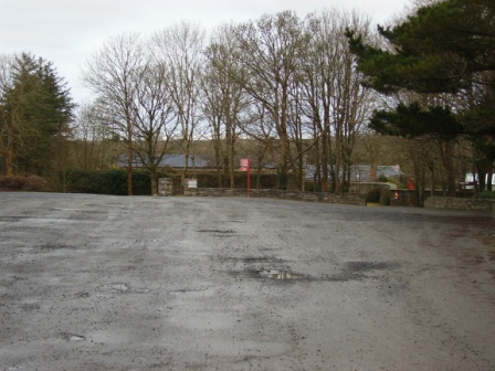
| Kilrush House | An early 19th century house, home of the Vandeleur family, though they were in residence in the eighteenth century as Wilson refers to Kilrush as the seat of Crofton Vandeleur in 1786. In the mid 19th century it was valued at £85. In 1897 it was completely destroyed by an accidental fire. The site of the house is now a car park for those wishing to visit the Vandeleur Walled Garden, which has recently been restored, or to walk in the woods. |
|
| Pella House | A Studdert home on the Vandeleur estate valued at £13 in the mid 19th century. Weir writes that the house was built by Admiral John Fitzgerald Studdert and it remained a Studdert home until 1900. Though a house is still extant at the site the original house is now ruinous. |
|
| Duagh Glebe | Sir John Benn-Walsh's estate was leasing this property to Rev. Robert Hickson at the time of Griffith's Valuation, when it was valued at £17. Lewis records it as the seat of Rev.R. Hickson in 1837. | |
| Ballinruddery House | Ballinruddery was owned by the Knight of Kerry at the time of Griffith's Valuation, when it was valued at £23 10s. This seems to be the house referred to by Wilson in 1786 as Woodford, "the seat of Robert Fitzgerald, with ample demesnes". Leet notes it as the residence of Hon. M. Fitzgerald in 1814. Lewis, in 1837, describes it as "the occasional residence of Maurice Fitzgerald, Knight of Kerry, beautifully situated in a wooded demesne". It is recorded by Slater as the seat of Sir Maurice Fitzgerald in 1894. Bary states that the house was believed to date from the sixteenth century but was destroyed by fire accidentally in the later nineteenth century. | |
| Aghangran House | Joseph Dexter was leasing this property from the Blacker estate at the time of Griffith's Valuation, when it was valued at £4. Leet recorded it as the seat of Thomas O'Connor in 1814. In 1837 Lewis mentions the house as the residence of J. O'Connor. The Ordnance Survey Name Books mention that John O'Connor was leasing the property from Maxwell Blacker in the 1830s. Bary notes that the house was associated with the O'Connor family earlier in the nineteenth century. It was later burned and subsequently demolished. | |
| Ballyline | St. John Blacker was leasing this property to Nicholas King at the time of Griffith's Valuation, when it was valued at £3 10s, on a holding of over 250 acres. Modern farm buildings exist at the site now. [Grid Reference is approximate]. | |
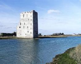
| Carrigafoyle Castle | Charles L. Sandes was leasing this property to Stephen Sandes at the time of Griffith's Valuation, when it was valued at £19 10s. It is described on the 1st edition Ordnance Survey Map as Carrigafoyle Castle but on the later 25" edition as Carrigafoyle House. In 1786 Wilson refers to it as "the ancient mansion of O'Connor Kerry, formerly a place of great strength and important.. but now serving as a store to transport goods from the adjacent places to Limerick". |
|
| Killelton House | Charles L. Sandes was leasing this property to William Hickie at the time of Griffith's Valuation, when it was valued at £33. Bary writes that this Hickie family were originally from Tulla, county Clare, but moved here after the Cromwellian confisciation of the 1650s. They remained in possession of the property until the 1920s. The Irish Tourist Association survey mentions that it was formerly the home of the Higgins-O'Connor family but by the 1940s was in poor repair. The original house is now a ruin. | |
| Cloonkerry House | Cloonkerry was an 18th century house on the Vandeleur estate. The house was occupied by Richard Brew in 1814 and by members of the Lloyd family in 1837 and in the 1850s. Weir writes that the house is now demolished. According to local information this house was once a police barracks. | |
| Clonderalaw | Weir writes that this house was either built or bought by a branch of the Studderts of county Limerick in the mid 18th century and that it remained their home until the mid 20th century. In 1786 Wilson refers to it as the seat of Mr. Studdert. It was part of the Wandesforde estate in county Clare. It was the home of Mrs Gore (nee Studdert) in the 1940s but according to the Irish Tourist Association surveyor it was not in good repair and "likely to go the way of all the other big houses of Clare". However it has survived into the 21st century with its roof on. In 1894 it was the residence of Captain George Studdert. | |
| Thornberry House | Originally a Brew family home, then a rectory and by the mid 19th century in the possession of the Studdert family held from Jane Robinson. Later the home of Colonel Thomas Lloyd. The house was demolished in 1949. | |
| Letter House | John Wren was leasing this property to Alicia Wren at the time of Griffith's Valuation, when it was valued at £13. Lewis records it as the seat of G. Wren in 1837. In 1814 Leet refers to Litter as the residence of John Wren. Bary writes that Letter was originally a Blennerhassett property which passed to the Wren family through marriage., It is still extant and owned by descendents of that family. | |
| Rushy Park or Rusheen Park | At the time of Griffith's Valuation, Rev. Samuel Leonard was leasing this property to Thomas O'Connor, when it was valued at £9 15s. Bary writes that this house was in the Leonard family in the early nineteenth century. It was demolished in the early twentieth century and a new house constructed at the site. | |
| Jane Mount | Pierce Mahony's estate was leasing this property to Jeremiah Dillane at the time of Griffith's Valuation, when it was valued at £7 5s. Bary states that the house is believed to have been built by Gun Cunningham in the eighteenth century. It passed through marriage to the Mahony family. The Dillon family have been in possession of the property since before the Famine. The original house is now ruined. | |
| Garryard | Thomas Dillane was leasing this property from the Mahony estate at the time of Griffith's Valuation, when it was valued at £5 10s. Bary states that the house is alleged to be over 300 years old and originally the property of the Newman family. In the eighteenth and early nineteenth century it was held by the Enright family and later passed to the Bolster family through marriage. It served as an auxilliary work house during the Famine and was also the location of the local creamery. It is still extant and occupied. | |
| Coolard House | At the time of Griffith's Valuation, Samuel Raymond, MD, was leasing this property to Patrick Dalton, when it was valued at £10 5s. A house still exists at the site. | |
| Tullamore House | Sir John Benn-Walsh was leasing this property to Laurence Buckley at the time of Griffith's Valuation, when it was valued at £12 10s. In 1814 Leet refers to it as the residence of Mrs. Julian. Wilson writing in 1786, mentions Tullamore as the seat of Rev. Mr. Julian. In 1837 Lewis noted it as the seat of C. Julian. Bary writes that it was a house mostly associated with the Julian family. It was derelict at the end of the twentieth century. | |
| Woodlands or Aghana | Robert Leslie was leasing this property to Pierce Leslie at the time of Griffith's Valuation, when it was valued at £8 15s. Lewis records it as the seat of Pierce Leslie in 1837. Bary notes that Robert Leslie was reared by Pierce Leslie, the owner of this property, when he succeeded his father at a young age. The house seems to have been known at times as Aghana House and is still extant and occupied | |
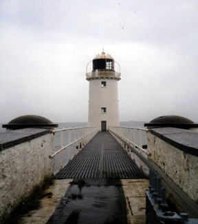
| Tarbert Lighthouse & Keepers House | At the time of Griffith's Valuation, Robert Leslie was leasing this property to the Board of Ordnance, when it included the lighthouse and lightkeeper's house and associated buildings, valued at £22. The lighthouse is still extant and operational. |
|
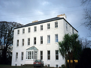
| Tarbert House | Tarbert House was owned by Robert Leslie at the time of Griffith's Valuation when it was valued at £24 10s. Both Leet in 1814 and Lewis, in 1837, note it as the seat of R. Leslie. In 1906 it was valued at £25. The National Inventory of Architectural Heritage suggests the house was built c.1720. In 1786 Wilson describes it as "happily situated on an eminence commanding an extensive view". The house has remained in the Leslie family since that time though the estate was sold to the tenants c.1904. It is open to the public during the summer months. |
|
| Sallowglen | William Sandes was leasing this property to Thomas Sandes at the time of Griffith's Valuation, when it was valued at £24. Lewis notes it as the seat of T.W. Sandes in 1837 as does Leet in 1814. Wilson, writing in 1786, refers to "Sallow Glin, the new and handsome house of William Sandes". In 1906 it was the property of Thomas W. Sandes and valued at £50. Bary writes that it was resided in by the Sandes family and their descendents until the 1920s when the estate was sold. It has since been demolished. | |
| Leslie Lodge or Shanaway | Pierce Mahony was leasing this property to James Patterson at the time of Griffith's Valuation, when it was valued at £12. Wilson refers to it as a seat of Robert Leslie in 1786. In 1814 Leet refers to Leslie Lodge as the residence of John Parker. Lewis, in 1837, records the purchase of the property by Col. D.G. Halliburton In 1856, it is included in the sale of the estate of George Phillip Gun Mahony, a minor, when it is described as untenanted. In 1906, Stephen Collis owned a property at Shanaway East, valued at £6. It is no longer extant. | |
| Tieraclea Lodge | At the time of Griffith's Valuation, Tieraclea was occupied by Stephen Collis, when it was valued at £42. An extensive farmyard is recorded here on the First Edition Ordnance Survey map. The house is labelled as Tieraclea on the later 25-inch map and by 1906 Tieraclea was valued at £45. Bary writes that it had been a residence of the Collis family since the eighteenth century and they continued there until the 1920s. In the early years of the twentieth century the house was destroyed by fire but was re-built and is still extant. | |
| Farranawana House | At the time of Griffith's Valuation, this property was being leased by St. John Blacker to the trustees of Glin Poor Law Union, as an auxilliary workhouse. By 1895 it is labelled on the Ordnance Survey map as Farrawanna House. A house and farm buildings are still extant at the site. | |
| Gurtenard | James M. Hone was leasing this property from the Earl of Listowel's estate at the time of Griffith's Valuation, when it was valued at £30 10s. Lewis indicates that it was the seat of S.E. Collis in 1837. It was used infrequently by the Earl and Countess of Listowel as a summer residence but most often let out to other families. It is still extant and sometimes operates as a guesthouse. |

|
| Dromin House | James Raymond was occupying this property at the time of Griffith's Valuation, when it was valued at £17 5s. In 1837 Lewis noted it as the seat of James Raymond while in 1814, Leet refers to it as the residence of James W. Raymond. In 1786 Wilson had also noted it as a seat of the Raymond family. In 1906 it was owned by the representatives of James Raymond and valued at £17. Bary states that this property was originally associated with the Fitzmaurice family, Lords Kerry, but that it passed to the Raymond family in whose possession it remained until the mid-twentieth century. It is still extant and occupied. | |
| Aughrim | At the time of Griffith's Valuation, Rev. R. Fitzgerald was leasing this property from the Blacker estate when it was valued at £6 and part of a holding of 600 acres. It is described as a Steward's house. Farm buildings still exist at the site. | |
| Moyvane Farm | At the time of Griffith's Valuation, William Sandes was leasing a property to Stephen Sandes at Moyvane North, valued at £3 5s, on a holdings of 150 acres. It is described as a farmhouse. | |
| Moyvane House | William L. Vesey-Fitzgerald Foster was leasing this property from the TCD estate at the time of Griffith's Valuation, when it was valued at £3 15s. In 1837 Lewis mentions the principal residence in Murher parish as the property of Baron Fitzgerald but occupied by Mr. Enright. In 1814, Leet refers to it as the residence of John Sandes. Bary notes that it was earlier associated with the Sandes family. It is no longer extant. | |
| Burrane | The Hodges lived here for over a hundred years following a marriage in 1754 with a Monsell of Burrane though Wilson still refers to it as the seat of Mr. Monsell in 1786. It was held from the Reeves family of nearby Besborough who came to hold the head rent through an 18th century marriage with a Spaight of Burrane. Weir writes that the house was demolished in the early 20th century. | |
| Besborough | Occupied by Reverend Theobald Butler in 1837 and still in his possession at the time of Griffith's Valuation. He held the property from Letitia Hickman and it was valued at over £22. By the 1870s this house was the home of Robert William Cary Reeves and it was still in his possession in 1906. Later in the 20th century the house became the home of the Hassett and Sexton families. | |
| Carrowdotia House | A house on the Vandeleur estate, it was the residence of William Daxon in 1814 and of R.D.Daxon in 1837. Valued at £17 at the time of Griffith's Valuation and occupied by James Cathro. This house now appears to be the centre of a working farm. |

|
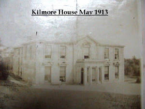
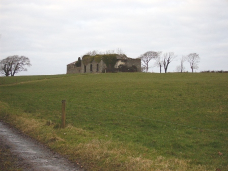
| Kilmore | The home of a branch of the Hickman family in the 18th and 19th centuries. In 1786 Wilson refers to it as the seat of Mr. Hickan. Inherited by the Gores in the 1860s. Burnt in July 1922. |
|
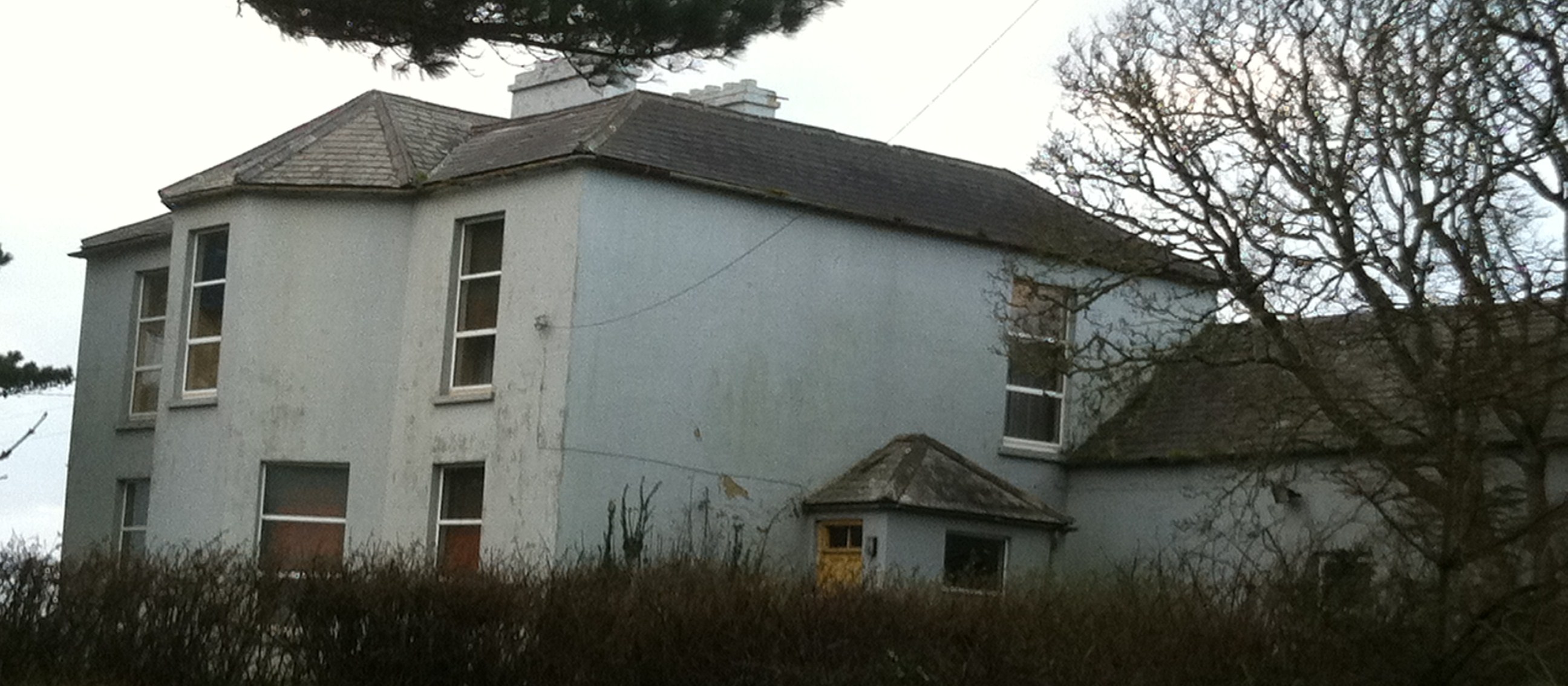
| Woodlawn House | Situated on the Hickman estate, this house valued at over £13 was unoccupied at the time of Griffith's Valuation and the lease held by Denis Culligan. Joseph Studdert had occupied the house in 1837. He was a grandson of Maurice Studdert of Elm Hill, county Limerick. One of Joseph's sons married Mary Gore of Tyredagh Castle and the Gore Hickmans appear to have occupied the house in the late 19th and early 20th centuries. This house is now a ruin. |
|
| Oaklands | A one storey 18th century house on the Hickman estates occupied by William Henn in 1814 and by R. Hunt in 1837. The residence of the Bennett family from at least the mid 19th century and sold by the Misses Bennett in 1929. | |
| Doonnagurroge Castle | Weir writes that this is a 17th century house with a Hodges coat of arms over a door. William Monsell is recorded as the proprietor of Donogroge, Kilrush in 1814. Situated on the Hickman estate it was occupied by George Crowe Hodges in 1837 and at the time of Griffith's Valuation. The Clare Journal (17 Nov 1856) records the death of this gentleman aged 70. The home of the Talty family in the later part of the 19th century. |
|
| Gunsborough | At the time of Griffith's Valuation, this was the property of Pierce Mahony and valued at £12 10s. It was leased to Listowel Board of Guardians as an auxilliary workhouse. In 1837 Lewis records it as the property of Pierce Mahony who had recently purchased the estate. Bary writes that it had previously been in the possesson of the Gun family. It is now ruined. | |
| Bedford House | Wilson refers to Bedford as the seat of Colthurst Bateman in 1786. In 1837 Lewis mentions Bedford House as the seat of S.S. Raymond.At the time of Griffith's Valuation, it was being leased by Samuel Raymond to Listowel Board of Guardians as an auxilliary workhouse and was valued at €25. Bary notes that this house was associated with the Bateman family and may have been built for the marriage of Colthurst Bateman in 1775. It is now a ruin. | |
| Cahirdown | In 1906 Denis Gun Browne owned a house valued at £20 at Dromin Upper, barony of Iraghticonnor. At the time of Griffith's Valuation, this had been been part of Rev. George Browne's estate, let to the Collins family, though the house was then valued at £1 10s. It is labelled Cahirdown on the 1895 map. | |
| Ballydonohoe | A property held by a junior branch of the Fitzgerald family. The house was the residence of John Church in 1814, Thomas Fitzgerald in 1837 and of St John Thomas Blacker in the early 1850s. It was valued at £13 at that time. |
|
| Caharagh House | Occupied by R.Q. Sleeman in 1837 and by Frederick Alms in the early 1850s who held the property from the Knight of Glin. This house was in the possession of George Fitzgerald Hartigan Putland in 1865 when it was advertised for sale on 107 acres and held under an accepted proposal for life of G.F.H. Putland from the Knight of Glin. Caheragh House is still extant. |
|
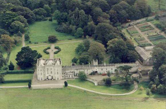
| Glin Castle | The home of the Knights of Glin, built in the 1780s and later castellated, it is situated on the Shannon estuary. Wilson refers to it in 1786 as" Glyn House, the pleasant seat of Mr. Fitzgerald". In the early 1850s it was valued at £50. The castle is still in the possession of the family but in 2015 was offered for sale. |
|
| Westwood | Reverend P. Fitzgerald wrote in 1826 that Lancelot Kiggell "lately built a beautiful cottage adjoining a fine old wood near Glin". This house was occupied by Lieutenant Hyde Royal Navy in 1837 and by John F.E. Fitzgerald, heir to the Knight of Glin in the early 1850s. The house shown on the 25-inch map of the 1890s is much reduced in size and it is no longer extant. | |
| Rock Lodge | This house was the home of Samuel Harding from at least 1814 to the mid 19th century. He held the property from the Earl of Clare. At the time of Griffith's Valution, it was occupied by Michael Harding and valued at £10. Home of the Behan family at the end of the 20th century. | |
| Belleview/Bellevue | A house located on the Vandeleur estate close to the town of Kilrush, the residence of Captain Jewell in 1814 and of Nicholas S. O'Gorman at the time of Griffith's Valuation, when it was valued at £11. Weir writes that this was a late 18th century house, still extant. |
|
| Cappagh Lodge | Another larger house in Ballynote West townland, valued at £18 at the time of Griffith's Valuation and occupied by Robert H. Borough, who held it from Nicholas S. O'Gorman. This house is labelled Cappagh Lodge on the 25-inch Ordnance Survey map of the 1890s. Local sources indicate it was later occupied by the Butler family. Later in the twentieth century it was taken over by the Ryan family whose descendants still live there. | |
| Shannon View (Tarbert) | At the time of Griffith's Valuation, Richard Hinde held a farmhouse at Coolnanoonagh, valued at £2 15s. A house labelled Shannon View appears at this location on the 25-inch edition Ordnance Survey map, published in the 1890s. A house is still extant at the site. | |
| Fort House | This house near the town of Kilrush was the residence of John Trousdell in 1814. Occupied by Richard Studdert in the early 1850s who held the house valued at £7 and three acres from Brew Cox Donovan. Weir writes that it was the agent's house for the Vandeleur estate at one time. | |
| Rusheen House | In 1786 Wilson refers to Rusheen as the seat of Mr. Crosbie. The 1st edition Ordnance map of the townland shows both Rusheen House and the site of "Rusheen Old House". At the time of Griffith's Valuation Stephen Sandes was leasing this property from the Crosbie estate. It included a herd's house valued at £1 5s. Bary writes that there were several marriages between members of the Crosbie and Sandes families in the eighteenth and nineteenth centuries. The house is no longer extant. | |
| Querrin Lodge | Querrin Lodge was enlarged after the publication of the 1st edition Ordnance Survey Map and Griffith's Valuation. Borough family history indicates that it became the property of Randal Borough of Cappagh Lodge in the early 1850s. It is labelled Querrin Lodge on the 25-inch edition map of the 1890s. The building is still extant but derelict. |