Knigh Cottage
Houses within 5km of this house
Displaying 23 houses.
Houses within 5km of Knigh Cottage
Displaying 23 houses.
| House name | Description | |
|---|---|---|
| Rapla | Rapla was a Freeman home in the 18th century and was inhabited for a time by the Otways, Phoebe Otway having married Daniel Freeman of Rapla. Wilson, writing in 1786, refers to Rapla as the seat of Mr. Willington. Jonathan Willington, younger brother of John of Killoskehane, was residing at Rapla in 1814 and William Cooper Crawford in 1837. William Cooper Crawford married Sophia Morgan [nee Willington] as her second husband. By the early 1850s John Tuthill was resident holding the house valued at £42+ from William Cooper Crawford. The sale rental of 1850 describes Rapla as a first class house held on a lease for 7 years from the Court of Chancery to John Tuthill. This house no longer exists. |

|
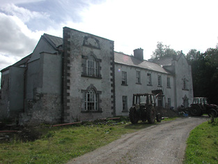
| Richmond | Bence Jones writes that this was a fortified house onto which a three storey house was built in 1733. The house was later altered and expanded. Richmond was the seat of the Gason family in the 18th and 19th centuries, originally known as Killashalloe. Occupied by Richard Gason in 1814 and in 1837 and held by him in fee in the early 1850s when it was valued at £46. This house remained in Gason possession until 1956 when the roof was removed and the farm was sold in 1962. Part of the facade of the Ulster Bank headquarters at George's Quay, Dublin, was constructed from blocks of stone from Richmond House (''The Irish Independent'', 16 March 1999) . | |
| Southhill | In 1840 the Ordnance Survey Name Books refer to South Hill House as "a good dwelling house, the residence of Mr. J. Manders" though Patrick Clark is mentioned as the proprietor. It was valued at £23+ in the mid 19th century, occupied by John Vincent and held from the Honourable O.F.G.Toler. At the time of the 1855 sale the house was untenanted. This house no longer exists. | |
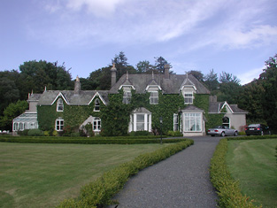
| Ashleypark | Ashleypark was occupied by the Heads from at least the 1770s. It was the home of John Head in 1814. It became the seat of a branch of the Atkinson family when purchased by George Guy Atkinson in 1824. G. Atkinson was the proprietor in 1837. George Atkinson held the property in fee at the time of Griffith's Valuation when the buildings were valued at £23.10 shillings. Thomas Biggs of the Bellevue family married Alice Margery Atkinson in 1903. The house was valued at £35 and occupied by Thomas B. Biggs Atkinson in 1906. His niece Zelie Biggs eventually inherited Ashleypark. The house was sold to Sean and Nora Mounsey in 1983. It now functions as a guest house. |

|
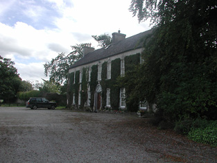
| St Davids | Lewis refers to the fishing lodge of the Very Reverend Gilbert Holmes, Dean of Ardfert, "beautifully situated on the banks of the Shannon". At the time of Griffith's Valuation, the lodge was valued at £13.10 shillings, occupied by B. W. Holmes and held from John D. and William Kellett. This fishing lodge was altered in the 1860s and renamed St Davids. It remained in the possession of the Holmes family until the 1980s and now functions as a guest house and restaurant. It was offered for sale in 2011. |
|
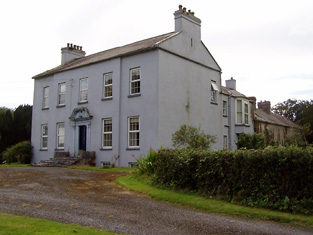
| Prior Park | Built circa 1780 to the design of William Leeson for James Otway, it became the seat of a branch of the Waller family in 1808. A small drawing of the house is included on the 1824 map. Occupied by W. Waller in 1837 and in the early 1850s, when the house was valued at £37 and held in fee. Members of the Waller family continued to reside here until the 1980s. Still a fine country residence. |

|
| Prospect | Taylor and Skinner record General Gabbet as the proprietor in the 1770s. This house was occupied by J. S. Handcock in 1837 and by Maurice Studdert in the early 1850s and held from Sir John Carden. The buildings were valued at £15.10 shillings. In 1840 it was described in the Ordnance Survey Name Books as "a good dwelling house with ornamental grounds, the residence of Thomas Purvis". Later leased to the Woodwards and still in use as a residence. |
|
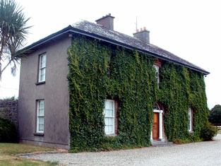
| Annaghbeg | The home of the Minnitt family in the 18th and 19th centuries, occupied by Joshua Minnitt in 1814. The Ordnance Survey name books describe it as " good dwelling house" in 1840. It wa the residence of Joshua R. Minnitt in 1837 and in the early 1850s. He held the property from the representatives of Eccles Cuthbert and the house was valued at £37. This house is still a country residence. |
|
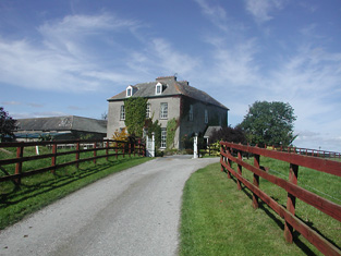
| Shannonvale/Kilteelagh | Occupied by Mrs Bunbury in 1814 and J. Odell in 1837. The Ordnance Survey Name Books describe it as "a spacious building, the residence of Mr. Cashel" in 1841. Peter Bailey was the occupier in the early 1850s, when the property was held from Mary Nunn. The buildings were valued at £10+. In the 1860s this house was replaced by a new building slightly to the north known as Kilteelagh House. It was built for Lieutenant Colonel W.C. Gason and is still a residence. It was offered for sale in 2012. Anoher Bayley property, known as Hazel Point Cottage, is located close by at R801860. |
|
| Johnstown Park | This house was built for Peter Holmes, MP, c. 1777 and probably designed by William Leeson. It was originally known as Peterfield. It was leased to Samuel Prendergast in 1823. Lewis records J.G. Prendergast as resident in 1837 and the Ordnance Survey Name Books refer to it as the residence of Counsellor Prendergast in 1840. The house valued at £49 was occupied by Thomas G. Prendergast in the mid 19th century and held from the representatives of Peter Holmes. From 1865 to 1936 Johnstown was the home of the Headech family. The house was unroofed in the early 1940s and is now demolished. |

|
| Lodge | An early 18th century house, originally the home of the Barry family, sold by them to Lieutenant Colonel Joseph Gabbett in 1766. Passed by inheritance from the Gabbetts to the Studderts, it was occupied by Francis Green in 1814 and by W. Studdart in 1837. The Ordnance Survey Name Books refer to it as "a commodious ancient dwelling house, the residence of William Studdert" in 1840. Maurice Studdert was the occupier at the time of Griffith's Valuation, when the house was valued at £25 and held from the representatives of General Gabbett. Maurice Studdert was the son of the Reverend George Studdert, rector of Kilpeacon, county Limerick, his wife, Mary Gabbett of High Park. Mrs Eliza Studdart of Lodge, Nenagh owned 648 acres in the 1870s. |
|
| Blackfort | William Molloy was resident in 1814 and W. Minnett in 1837. Blackfort was advertised for sale in May 1851 by the Reverend David Fitzgerald, Edward Galwey was the petitioner. By the time of Griffith's Valuation Edward Galwey held Blackfort, or Lisduff as it became known, in fee. The buildings were valued at £15.10 shillings. Edward Galwey of Lisduff, Nenagh, owned 245 acres in county Tipperary in the 1870s. Richard Galway occupied Blackfort in 1906 when the house was valued at £22+. |
|
| Ballinwear | In 1840 the Ordnance Survey Name Books describe Ballinwear as "a good dwelling house...surrounded with plantation and ornamental ground". James Otway is recorded as the occupier of Ballinwear at the time of Griffith's Valuation. At this time the house was valued at £14 and held from the Earl of Norbury. Toler Kingsley Wolfe was the house occupant in 1867. The Ballinwear property had been leased to Caesar George Otway by the Honourable Otway Fortescue Toler in 1859. The house was later altered and a building is still in existence at the site. | |
| Ballyanny | Lewis records J. Maher as resident at Ballyhenny in 1837. James Meagher occupied the house valued at £16 in the mid 19th century and held the property from Thomas Carroll. James Meagher of Ballyanny, Nenagh, owned 370 acres in the 1870s. | |
| Wellington | In 1840 the Ordnance Survey Name Books refer to Wellington as "the commodious dwelling house of Edwin Sadlier". By the time of Griffith's Valuation, the house was occupied by Daniel Falkiner, valued at £20 and held from the representatives of Colonel Brereton. This house is marked on the first edition Ordnance Survey map. It was replaced by another house also known as Wellington, closer to the mill, in the early 1870s, and this latter house is still extant. |

|
| Rockford | The original house was marked on the first edition Ordnance Survey map but it was enlarged and altered sometime after the first Ordnance Survey. Another house also known as Rockford House was built to the south east of the original house in 1881 for Theobald Richard Wolfe, Grid Ref R855 821. It remained in the possession of the Wolfe family until 1943. Rockfort (sic) was the residence of Jeoffrey Kingsley in 1814 and of J. Wolfe in 1837. In 1823 John Wolfe married Frances Elizabeth Kingsley, an only child. John Wolfe held the house valued at £18 and 232 acres from the representatives of General Chowe in the early 1850s. The Wolfes were still resident in the 1870s. |

|
| Moyroe | Moyroe was the home of Samuel Laurence in 1814 and of Malachy Ryan in the mid 19th century. Malachy Ryan held the townland of 51 acres in fee and the buildings were valued at £10.10 shillings. A building still exists at this site. | |
| Brook Watson | Feltham Watson occupied Brook Watson in 1837 and at the time of Griffith's Valuation when the house was valued at £26 and held from the representatives of Peter Holmes. By 1870 in the hands of the Brereton family. |

|
| Cloghprior House | The home of the Woodward family until sold to Edwin Cuthbert in 1844. The Ordnance Survey Name Books describes it as "at present in a state of very bad repair, but bears marks of ancient splendour". Held by Edwin Cuthbert in fee at the time of Griffith's Valuation and valued at £5.5 shillings. Daniel Grace writes that it was renovated by John Flower circa 1860s and leased to John Talbot. The Talbot family continued to reside at Cloghprior until the early 20th century. | |
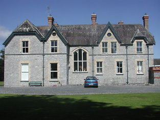
| Kilruane House | A house constructed in the later nineteenth century on lands owned by Sir Mark A.H. Tuite. It is labelled Kilruane House on the 25-inch Ordnance Survey map of the 1890s. In 1894 Slater notes it as the residence of Sir Mark Tuite. It is still extant and occupied. |
|
| Woodpark (Cloghprior) | In 1841 the Ordnance Survey Name books refer to Woodpark as "a new house, the occasional residence of George Waller". At the time of Griffith's Valuation, it was held in fee by William Waller and valued at £7. Woodpark is now a ruin. | |
| River View (Knigh) | James Kingsley was leasing this property from the Farrar estate at the time of Griffith's Valuation, when it was valued at £10+. In 1840 the Ordnance Survey Name Books refer to River View House as "a commodious dwelling house, the residence of John Tuthill, esq.". Buildings are still extant at the site. | |
| Millview | In 1840 the Ordnance Survey Name Books describe Mill view as "a good dwelling house, the residence of Mr. Short" though noting S. Pepper as the proprietor. At the time of Griffith's Valuation it was leased by Richard Brandley from Mary O'Leary when it was valued at £11. A house is still extant at the site. |