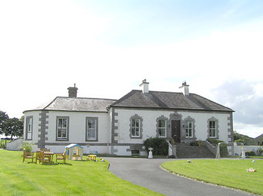
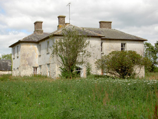
Aghamore House
Houses within 10km of this house
Displaying 27 houses.
Houses within 10km of Aghamore House
Displaying 27 houses.
| House name | Description | |
|---|---|---|
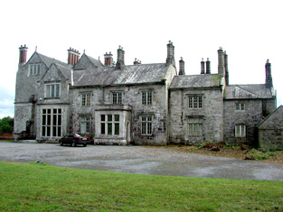
| Lough Rynn | Lough Rynn was built in the early 1830s by Robert, Viscount Clements, heir to the 2nd Earl. At the time of Griffith's Valuation it was valued at £40. In 1906 it is recorded as the property of Col. H.T. Clements and has a valuation of £100. It is still extant. In 2006 it opened as a luxury hotel. For more information see www.loughrynn.ie and www.loughrynn.net. |
|
| Derrycarne | At the time of Griffith's Valuation Derrycarne was the property of William Ormsby Gore and was valued at £30. Lewis records it as the seat of the Nisbett family in 1837. In 1906 it was in the possession of Lord Harlech (Ormsby Gore) and was valued at £33. The Ormsby Gore estate was eventually sold in 1924 and Derrycarne and about 80 acres were acquired by a Col. Kirkwood, a relative of the Kirkwood family of Woodbrook, county Roscommon. It changed hands again several times before being acquired by the Land Commission in 1952. The house was demolished shortly afterwards. | |
| Lakefield | Lakefield House was associated with the Crofton family since the mid eighteenth century . A new house was constructed between 1771-1798. At the time of Griffith's Valuation it was leased by Duke Crofton from Hugh Carmichael,M.D. and was valued at £25. The house continued in Crofton ownership until 1931 when the estate was purchased by the Land Commission. It is now a ruin. | |
| Aughry House | Aughry House built after the publication of the First Edition Ordnance Survey map. At the time of Griffith's Valuation it was owned and occupied by Charles T. Ward and was valued at £13. Aughry Castle (in ruins) is visible nearby on the 1st edition map. This may be the property referred to in 1786 by Wilson as the seat of Mr. Nesbit. Elaborate modern entrance gates identify Aughry House which appears to be close to the site of the original. | |
| Drumard House | Rev. Thomas Jones was leasing a property at Drumard, barony of Mohill, valued at £25 to William Jones at the time of Griffith's Valuation. It is no longer extant. | |
| Georgia | At the time of Griffith's Valuation, the Forbes estate was leasing a house valued at £6 to Andrew McCloughesy at Georgia or Gorteenoran. The premises is visible on the early 20th century maps but the site is now occupied by a hotel complex. | |
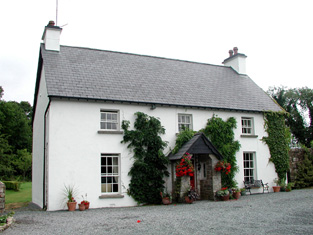
| Gort House | Margaret O'Brien was leasing a house valued at £15 in the townland of Gortnalamph from the Clements estate in the 1850s. Gort House is still extant and occupied. |
|
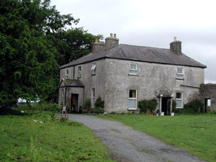
| Clooncoe House | Lewis records "Brooklawn" as a seat of the O'Brien family in 1837. Brooklawn House in the townland of Clooncoo, parish of Cloone, was part of the Clements estate but is described at the time of the first Ordnance Survey as the seat of a Mr. Crawford. It is labelled Brooklawn on the 1st edition Ordnance Survey map but as Clooncoe House on all subsequent editions. It is still extant and occupied. |
|
| Kilmore House | Built by the Reverend Edward King, Bishop of Elphin circa 1630. Home of a branch of the Lawder family in the 18th century until the murder of James Lawder in 1779. The Auchmuty family resided at Kilmore in the 19th century. The demesne was named Aghaward on the first Ordnance Survey map. A large farm is still extant at the site. | |
| Gillstown | The residence of Mr John Stafford in 1749 and of J. Hogg in 1837. Occupied by Thomas Cox in the second half of the 19th century, who held the property from John Blakeney. Valued at £5 in the 1850s. In 1906 the buildings at Gillstown were valued at £8.10s and were occupied by the representatives of Thomas Cox. | |
| Ballycummin | A house valued at £8 when occupied by Roderick J. Hanley, who held it from Laurence Murray, at the time of Griffith's Valuation. Described by Lewis in 1837 as the former seat of the Earl of Roscommon and at that time occupied by Lieutenant Rodrick J. Hanly. | |
| Tully Lodge | Built circa 1820, occupied by J. W. Kelly in 1837 and by Christopher Lawder in the 1850s who held the property in fee. It was valued at £20. Occupied by Samuel Russell in 1906. Another house marked as Lakeview was in the demesne grounds at the time of the first Ordnance Survey. In 1837 W. McDonnell was residing in Lakeview [M987 921] |
|
| Sallyfield | A Hanly home from at least 1749 but by the 1850s held by George Lawder in fee. It was described at this time as a steward's house with offices and a lodge, valued at £3. It is labelled on both the 1st and 25-inch edition Ordnance Survey Maps as Sallyfield. It is no longer extant. A house named Cottage was also in the townland of Lavagh at N005 895 on both maps. | |
| Rooaun Lodge | At the time of Griffith's Valuation occupied by John Morton and held by him in fee, valued at £3. A house at Rooaun valued at £18 was occupied by T.A.F. O'Flaherty in 1906. | |
| Moss Hill | Occupied by Peter Conry in 1814 and by Captain Conry in 1837. | |
| Clooncahir | John Walsh was the lessor of a vacant house valued at £12 at Clooncahir, barony of Mohill at the time of Griffith's Valuation. He was leasing lands in the same area from the Crofton estate. A house still exists at the site. | |
| Drumod More | At the time of Griffith's Valuation, Catherine Warren was leasing a house valued at £9 to Francis Murphy at Drumod More, barony of Mohill. Extensive redevelopment and road building have taken place in this area though there are still buildings at the site. | |
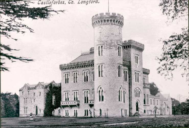
| Castleforbes | The National Built Heritage Service suggests the current Castleforbes House dates from the middle third of the 19th century but incorporating the fabric of its 17th and 18th century predecessors. At the time of Griffiths Valuation in the early 1850s, it was valued at £80. It was occupied by Lady Forbes at that time. It served as the main seat of the Forbes family, Earls of Granard, since the 17th century. In 1906 it was valued at £110. It is still extant. |
|
| Rose Cottage (Clongesh) | John V. Crawford was leasing this property from the Earl of Granard’s estate at the time of Griffiths Valuation in the early 1850s when it was valued at £15. It is labelled as Rose Cottage on all editions of the Ordnance Survey maps. A later house exists at the site. | |
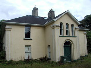
| Lisbrack House [Bishop's House] | In 1837 Lewis noted Lisbrack Cottage as the seat of Verschoyle Crawford. At the time of Griffiths Valuation in the early 1850s, the representatives of George Crawford were leasing this property to James Bell, when it was valued at £15. In 1868 George Crawford and others offered for sale 13 acres at Lisbrack, known as the Cottage holding, in the Landed Estates Court. This holding was occupied at the time by James Bell. The National Built Heritage Service suggests the building on the site now was built in the 1870s with an ecclesiastical purpose but that it replaced an earlier house, possibly known as Lisbrack House. The current building later served as a convent and as a school. | |
| Moneylagan Cottage | In 1837 Lewis referred to Moneylagan as the seat of Dr. Forbes Crawford. At the time of Griffiths Valuation in the early 1850s it was leased by General James Hey from John Crawford when it was valued at almost £14. The 1840 Valuation Office books show a £15 valuation. An altered house is extant at the site now. | |
| Brianstown House | In 1837 Lewis refers to Brianstown as the seat of Thomas G. Auchmuty. At the time of Griffiths Valuation in the early 1850s, it was held in fee by Henry Musters when it was valued at £22. The earlier Valuation Office books from 1840 note Auchmuty as the owner and the Valuation as £24. In 1814 Leet referred to it as the residence of Samuel Auhmuty. Brianstown is still extant and occupied. |
|
| Lismoy Upper | Mrs. Fitzgerald was leasing this property from the Governors of Mercer’s Hospital at the time of Griffith’s Valuation, in the early 1850s, when it was valued at £18. The National Built Heritage Service suggests that the original house was built in the late 18th century but underwent several modifications in the 19th century. In 1837 Lewis recorded it as the seat of a Reverend J. Mitchell. Leet referred to it as the residence of Reverend Kilner Davidson in 1814. In the 1870s it was noted as an address for “H. Dundas”. It is still extant and occupied. |
|
| Corry House | The 1906 record of Untenanted Demesnes records buildings valued at £18 at Corry, parish of Clongesh and barony of Longford. The owner was Colonel H.M.S. Douglas. This property was also part of the Douglas estate at the time of Griffiths Valuation in the early 1850s when it was valued at over £3 and occupied by James Berry. The National Built Heritage Service suggests Corry House was originally built in 1845 but significantly altered in the 1880s. It is still extant. |
|
| Carrickmoyragh House | Thomas Gregory was leasing this property from John Jessop’s estate at the time of Griffiths Valuation in the 1850s when it was valued at over £6. The National Built Heritage Service suggests that the current house was built sometime in the mid-19th century. A smaller house is shown at the site on the 1st edition Ordnance Survey map of 1838. A larger property is labelled Carrickmoyragh House on the 25-inch edition of the early 20th century. It is still extant though not in use. |
|
| The Hermitage (Clongesh) | In 1906 Tobias Peyton owned a property at Breanrisk valued at almost £15. This had been the family home of his mother, Frances Ellis. At the time of Griffiths Valuation in the early 1850s it was occupied by Thomas H. Ellis and valued at £8. The National Built Heritage Service suggests the original house dates from c.1780. It is labelled The Hermitage on the 25-inch Ordnance Survey map of the early 20th century, the name by which it is still known. |
|
| Corry House (Ballymahon) | Joseph Allen was leasing this property from the White estate at the time of Griffiths Valuation, when it was valued at £10. The earlier Valuation Office records indicate it was occupied by John Murphy in 1840, with a valuation of £14. The National Built Heritage Service suggests the original house was built c.1845 and modified c.1880. The house is labelled Corry House on the 25-inch edition Ordnance Survey map of the early twentieth century. It is still extant |