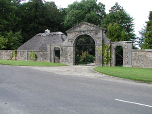
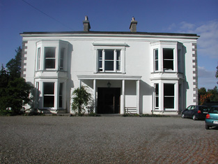
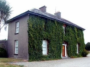
Kilcolman
Houses within 10km of this house
Displaying 51 houses.
Houses within 10km of Kilcolman
Displaying 51 houses.
| House name | Description | |
|---|---|---|
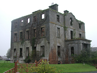
| Solsborough | In 1786 Wilson refers to "Sallborough" as the seat of Mr. Poe. T. Poe was residing at Salisboro in 1837. At the time of Griffith's Valuation (1850) James J. Poe held the property from the Court of Exchequer. The buildings were valued at £41. At the time of the 1852 sale James J. Poe was the tenant holding the property on a 7 year lease pending the cause of Crofts v Poe. Henry H. Poe of Solsborough owned 314 acres in county Tipperary in the 1870s. This house is now a ruin. |
|
| Rapla | Rapla was a Freeman home in the 18th century and was inhabited for a time by the Otways, Phoebe Otway having married Daniel Freeman of Rapla. Wilson, writing in 1786, refers to Rapla as the seat of Mr. Willington. Jonathan Willington, younger brother of John of Killoskehane, was residing at Rapla in 1814 and William Cooper Crawford in 1837. William Cooper Crawford married Sophia Morgan [nee Willington] as her second husband. By the early 1850s John Tuthill was resident holding the house valued at £42+ from William Cooper Crawford. The sale rental of 1850 describes Rapla as a first class house held on a lease for 7 years from the Court of Chancery to John Tuthill. This house no longer exists. |

|
| Debsborough | The seat of the Bayly family in the 18th and 19th centuries, occupied by successive John Bayly/Bailys and held in fee. The Ordnance Survey Name Books describe it as "a large demesnewith commodious dwelling house" in 1840. In the mid 19th century the house was valued at £38+ and in 1906 at £65. A building is still located at this site. | |
| Ballynaclogh House | The home of Richard Uniacke Bayly and his family in the 19th century, held from his brother John. The house was valued at almost £17 at the time of Griffith's Valuation. This house is still extant and occupied. |
|
| Bayly's Farm | The home of Lancelot P. Bayly and his family in the 19th century, held from his brother John. The house was valued at £13.6 shillings at the time of Griffith's Valuation. This house with modern additions still functions as a residence. It also offers guest accommodation. See www.baylyfarm.ie. |
|
| Coolagh | Coolagh is described in the Ordnance Survey Name Books as "a good dwelling house in a small demesne with plantation and ornamental ground" in 1841. It was occupied by John Brindley in the mid 19th century. Valued at £12+ it was held from the Very Reverend Dean Head. It is still extant. | |
| Happygrove House | In 1840 the Ordnance Survey Name Books refer to "Happy Grove" as "the name of the place and residence of Mr. John Brindley" and gives details of the oatmeal mill in the demesne. Samuel Brindley was the proprietor of a corn mill and house at Clonmore in the mid 19th century. He held the property from Lord Dunalley and the buildings were valued at £35. The house no longer exists. | |
| Richmond | Bence Jones writes that this was a fortified house onto which a three storey house was built in 1733. The house was later altered and expanded. Richmond was the seat of the Gason family in the 18th and 19th centuries, originally known as Killashalloe. Occupied by Richard Gason in 1814 and in 1837 and held by him in fee in the early 1850s when it was valued at £46. This house remained in Gason possession until 1956 when the roof was removed and the farm was sold in 1962. Part of the facade of the Ulster Bank headquarters at George's Quay, Dublin, was constructed from blocks of stone from Richmond House (''The Irish Independent'', 16 March 1999) . | |
| Traverston | Traverston was the seat of the Going family in the 18th and 19th centuries. In 1786 Wilson refers to it as Trevor's-town, the seat of R.Going. It was the residence of Thomas Going in 1814 and 1837. The Ordnance Survey Name Books describe it as "a splendid residence" in 1840. In the mid 19th century Caleb Going occupied the house and held the property in fee. The buildings were valued at £52+. Still valued at £52 and occupied by John R. Lloyd in 1906. John R. Lloyd was the son of Anne, daughter of Robert Going of Cragg, Newport, who, in 1828, married Edward Lloyd of 12 Upper Mount Street, Dublin. John R. Lloyd died unmarried in 1910 and left Traverston to his niece, Ann Norris. This house is now demolished. see http://www.glendafae.com/histories/Going%20of%20TRAVERSTON.pdf | |
| Southhill | In 1840 the Ordnance Survey Name Books refer to South Hill House as "a good dwelling house, the residence of Mr. J. Manders" though Patrick Clark is mentioned as the proprietor. It was valued at £23+ in the mid 19th century, occupied by John Vincent and held from the Honourable O.F.G.Toler. At the time of the 1855 sale the house was untenanted. This house no longer exists. | |
| Islandbawn | Malachi Ryan held a house, offices, flour mill and 76 acres at Islandbawn from the Honourable O.F.G. Toler at Islandbawn in the mid 19th century. The buildings were valued at £85. |
|
| Kilboy | In 1786, Kilboy was described by Wilson as the fine seat of Henry Prittie. Lord Dunalley is recording as resident at Dunally Castle, Nenagh, in 1814. In 1837 Lewis writes that Kilboy, the seat of Lord Dunalley, "was erected about 60 years since". In the mid 19th century it was valued at £76+ and held in fee. This house, which the National Inventory of Architectural Heritage describes as a "detached five-bay single-storey house over basement, built c. 1775" and designed by William Leeson, was destroyed in 1922. A similar house was erected on the site but was demolished in 1955. A smaller house is now located on the site. |
|
| Lissenhall | In 1786 Wilson mentions Lissen-Hall as the seat of Mr. Otway. Mr Thomas Devoy occupied Lissenhall in 1814 and in 1837 Rowan P. Cashel was resident. Margaret Dagg held the house valued at £42.13 shillings from the Honourable Mrs Otway Cave at the time of Griffith's Valuation. Lissenhall dwelling house and 242 acres bought for £5000 by William H. Carrol in 1853. In 1906 the mansion house in Lissenhall townland was valued at £30 and occupied by Alice J. Carroll. This house no longer exists. | |
| Rathurles | Rathurles was the home of the Brereton family in the 19th century. Occupied by John Brereton in 1814 and T. Brereton in 1837. In 1840 the Ordnance Survey Name Books refer to it as "a modern building". Thomas Brereton was still resident at the time of Griffith's Valuation holding the property valued at £27.15 shillings from Patrick Kernan. Home of Hugh Finch in the 1870s. This house is still extant and occupied. |
|
| Ballintogher House | In 1786 Ballintogher is referred to by Wilson as the seat of Mr. Strafford. Afterwards it was a Crawford property, occupied in 1814 by John Crawford. George Langford of Ballintogher House was the third son of Richard Coplen Langford who, in 1784, married Catherine Cooper Crawford of Fermoyle. In 1828, George married Maria, daughter of the Reverend Henry Bayly of Bayley's Farm, county Tipperary. In 1840 the Ordnance Survey Name Books refer to the house as "the residence of Attorney Langford". By the time of Griffith's Valuation George Langford held Ballintogher and 236 acres in fee. The house was valued at £20. A building is still located at this site. | |
| Ballyquiveen | A house built post the first edition Ordnance Survey map of circa 1838. John Brindley was leasing a house from Dean Head valued at £5+ at Ballyquiveen at the time of Griffith's Valuation. It is no longer extant. | |
| Tullahedy | Dominick Meade of Tullaheady, county Tipperary, died in 1717. Edwin Sadleir held a house valued at £15+ and 64 acres at Tullahedy from John O'Dwyer at the time of Griffith's Valuation. By 1906 Tullahedy valued at £16 was occupied by the representatives of Thomas J.R. Miller who held over 500 acres of untenanted land there. The Riggs Millers are still resident at Tullahedy. The Ordnance Survey Name Books record the existence of Tullahedy Old House, "almost in a state of ruins, occupied by a herdsman, but formerly a good dwelling house occupied by the Tumpane family". This property is shown on the 1st edition Ordnance Survey map at R841771. | |
| Ashleypark | Ashleypark was occupied by the Heads from at least the 1770s. It was the home of John Head in 1814. It became the seat of a branch of the Atkinson family when purchased by George Guy Atkinson in 1824. G. Atkinson was the proprietor in 1837. George Atkinson held the property in fee at the time of Griffith's Valuation when the buildings were valued at £23.10 shillings. Thomas Biggs of the Bellevue family married Alice Margery Atkinson in 1903. The house was valued at £35 and occupied by Thomas B. Biggs Atkinson in 1906. His niece Zelie Biggs eventually inherited Ashleypark. The house was sold to Sean and Nora Mounsey in 1983. It now functions as a guest house. |

|
| St Davids | Lewis refers to the fishing lodge of the Very Reverend Gilbert Holmes, Dean of Ardfert, "beautifully situated on the banks of the Shannon". At the time of Griffith's Valuation, the lodge was valued at £13.10 shillings, occupied by B. W. Holmes and held from John D. and William Kellett. This fishing lodge was altered in the 1860s and renamed St Davids. It remained in the possession of the Holmes family until the 1980s and now functions as a guest house and restaurant. It was offered for sale in 2011. |
|
| Annaghbeg | The home of the Minnitt family in the 18th and 19th centuries, occupied by Joshua Minnitt in 1814. The Ordnance Survey name books describe it as " good dwelling house" in 1840. It wa the residence of Joshua R. Minnitt in 1837 and in the early 1850s. He held the property from the representatives of Eccles Cuthbert and the house was valued at £37. This house is still a country residence. |
|
| Shannonvale/Kilteelagh | Occupied by Mrs Bunbury in 1814 and J. Odell in 1837. The Ordnance Survey Name Books describe it as "a spacious building, the residence of Mr. Cashel" in 1841. Peter Bailey was the occupier in the early 1850s, when the property was held from Mary Nunn. The buildings were valued at £10+. In the 1860s this house was replaced by a new building slightly to the north known as Kilteelagh House. It was built for Lieutenant Colonel W.C. Gason and is still a residence. It was offered for sale in 2012. Anoher Bayley property, known as Hazel Point Cottage, is located close by at R801860. |
|
| Lodge | An early 18th century house, originally the home of the Barry family, sold by them to Lieutenant Colonel Joseph Gabbett in 1766. Passed by inheritance from the Gabbetts to the Studderts, it was occupied by Francis Green in 1814 and by W. Studdart in 1837. The Ordnance Survey Name Books refer to it as "a commodious ancient dwelling house, the residence of William Studdert" in 1840. Maurice Studdert was the occupier at the time of Griffith's Valuation, when the house was valued at £25 and held from the representatives of General Gabbett. Maurice Studdert was the son of the Reverend George Studdert, rector of Kilpeacon, county Limerick, his wife, Mary Gabbett of High Park. Mrs Eliza Studdart of Lodge, Nenagh owned 648 acres in the 1870s. |
|
| Blackfort | William Molloy was resident in 1814 and W. Minnett in 1837. Blackfort was advertised for sale in May 1851 by the Reverend David Fitzgerald, Edward Galwey was the petitioner. By the time of Griffith's Valuation Edward Galwey held Blackfort, or Lisduff as it became known, in fee. The buildings were valued at £15.10 shillings. Edward Galwey of Lisduff, Nenagh, owned 245 acres in county Tipperary in the 1870s. Richard Galway occupied Blackfort in 1906 when the house was valued at £22+. |
|
| Ballinwear | In 1840 the Ordnance Survey Name Books describe Ballinwear as "a good dwelling house...surrounded with plantation and ornamental ground". James Otway is recorded as the occupier of Ballinwear at the time of Griffith's Valuation. At this time the house was valued at £14 and held from the Earl of Norbury. Toler Kingsley Wolfe was the house occupant in 1867. The Ballinwear property had been leased to Caesar George Otway by the Honourable Otway Fortescue Toler in 1859. The house was later altered and a building is still in existence at the site. | |
| Ballyanny | Lewis records J. Maher as resident at Ballyhenny in 1837. James Meagher occupied the house valued at £16 in the mid 19th century and held the property from Thomas Carroll. James Meagher of Ballyanny, Nenagh, owned 370 acres in the 1870s. | |
| Wellington | In 1840 the Ordnance Survey Name Books refer to Wellington as "the commodious dwelling house of Edwin Sadlier". By the time of Griffith's Valuation, the house was occupied by Daniel Falkiner, valued at £20 and held from the representatives of Colonel Brereton. This house is marked on the first edition Ordnance Survey map. It was replaced by another house also known as Wellington, closer to the mill, in the early 1870s, and this latter house is still extant. |

|
| Rockford | The original house was marked on the first edition Ordnance Survey map but it was enlarged and altered sometime after the first Ordnance Survey. Another house also known as Rockford House was built to the south east of the original house in 1881 for Theobald Richard Wolfe, Grid Ref R855 821. It remained in the possession of the Wolfe family until 1943. Rockfort (sic) was the residence of Jeoffrey Kingsley in 1814 and of J. Wolfe in 1837. In 1823 John Wolfe married Frances Elizabeth Kingsley, an only child. John Wolfe held the house valued at £18 and 232 acres from the representatives of General Chowe in the early 1850s. The Wolfes were still resident in the 1870s. |

|
| Moyroe | Moyroe was the home of Samuel Laurence in 1814 and of Malachy Ryan in the mid 19th century. Malachy Ryan held the townland of 51 acres in fee and the buildings were valued at £10.10 shillings. A building still exists at this site. | |
| Tyone | In the 1770s Donagh O'Brien of Tyone had bolting mills near Nenagh and an estate worth £8,000 in England and Ireland (Kilboy Papers). Donough O'Brien was resident at Tyone, Nenagh, in 1814. Malachy Ryan held a house, flour mill and land from Stafford O'Brien at Tyone in the mid 19th century. The buildings were valued at £75. Thomas John Ryan son of Malachy was living at Tyone in the 1870s. This house is still a residence. |
|
| Brook Watson | Feltham Watson occupied Brook Watson in 1837 and at the time of Griffith's Valuation when the house was valued at £26 and held from the representatives of Peter Holmes. By 1870 in the hands of the Brereton family. |

|
| Riverston | Leets records Riverstown, Nenagh, as the home of Wills Crofts. In 1806 John Bennett of Cork city married the only daughter of Wills Crofts of Riverston, county Tipperary (''Freeman's Journal'' 12 June 1806). In 1837 John Bennett was the proprietor of Riverston. At the time of Griffith's Valuation John Bennett held the property from the representatives of Peter Holmes and the house was valued at £55 and the nearby mill at £54. The home of a member of the Poe family in the 1870s. |

|
| Summerville | In 1840 the Ordnance Survey Name Books describe Summerville as "a commodious dwelling house, the residence of O'Brien Dillon" but Major Laurence is noted as the proprietor. At the time of Griffith's Valuation, the house was occupied by the representatives of Wills Bennett and held from John Bennett. The buildings were valued at £24. This house no longer exists. | |
| Castlelough | A circa 1820s house attached to an earlier building on the shore of Lough Derg, Castlelough was the seat of the Parker family. In 1786 Wilson refers to Castlelough and Castletown as seats of the Parker family. Occupied by Anthony Parker in 1814 and in 1837 who was succeeded in that year by his brother the Reverend Standish Grady Parker. The representaives of the Reverend Standish occupied the house at the time of Griffith's Valuation when the buildings were valued at £51+ and held in fee. The Parkers were still resident at the end of the 19th century. This house is still in use as a country residence. |
|
| Landsdown | In 1786 Wilson refers to "Land's-town" as the seat of Mr. Rolleston. The home of W. Parker in 1814 and of Mrs Parker in 1837. In 1840 the Ordnance Survey Name Books refer to "Landstown, a good dwelling house, the residence of William Parker". He was also the occupant in the mid 19th century when the house was valued at £55+ and held in fee. John Parker of Brookfield and Landsdown married Helena, daughter of George Washington Biggs of Bellevue. The Parkers were still resident in the 1870s. Bassett's Directory of 1889 refers to Charles E. Tuthill of Landsdown. In the 20th century the home of the White Spunner family. This house, built in 1779, was for sale in 1991 (see ''Country Life'' Volume 185). It is still extant. |
|
| Greenhall | A home of the White family in the 18th and 19th centuries, In 1786 Wilson refers to Greenhall as the seat of Mr. White. Lewis records H. White of Green Hall in 1837. The Ordnance Survey Name Books refer to it as "a neat dwelling house, the residence of H. White" in 1840 though it implies that "Counsellor Grady" was the proprietor. James Grace was resident in the mid 19th century when the house was valued at £12+. A building is still located at this site. | |
| Shallee | The Youngs appear to have been located in Shallee from at least the mid 18th century. Leet records Mr Francis Young as resident in 1814. In 1840 and at the time of Griffith's Valuation Francis E. Young was the occupant, holding the property from George Cashin [Cashel]. The buildings were valued at £20+. The sale rental of 1868 refers to a lease dated 1853 from Edward Worth Newenham to George Cashel of Shallee House. A house is still extant at Shallee. | |
| Cranna | The original home of the Going family in county Tipperary, inhabited by the Reverend John Going, eldest son of Richard Going of Birdhill in 1814 and by his son Charles in 1837 and at the time of Griffith's Valuation, when the house was valued at £23+. Buildings are still located at this site. | |
| Bushfield | In 1786, Wilson refers to Bushfield as the seat of Mr. Cashell. Francis W. Cashell was living at Bushfield, Nenagh, in 1814 and J. Philips in 1837. Henry Phillips was the occupant at the time of Griffith's Valuation when the house was valued at £14 and held from Henry Cashin [Cashel]. This house appears to be still extant. see http://humphrysfamilytree.com/Cashel/henry.bushfield.html | |
| Tullamore Park | A late 18th century house built for Edward Finch. It was the seat of the Finch family in the 19th century, occupied by William Finch in 1837 and at the time of Griffith's Valuation, when the house was valued at £27 and held in fee. Sold in the early 20th century to the Kennedy family. This house is still in use as a residence. |
|
| Youghal House | In 1837 Lewis refers to the seat of W.Smithwick "surrounded by thriving plantations". The house was valued at £39 at the time of Griffith's Valuation and held by William Smithwick in fee. The Smithwicks were still resident at Youghal House in the 1970s. |
|
| Youghal Lodge | Located on the shore of Lough Derg this house is referred to in the Ordnance Survey Name Books in 1840 as Youghal Cottage. However it appears on both the 2st and 25-inch edition maps as Youghal Lodge. At that time it was owned by William Smithwich but Captain Barton was living there. It was occupied by Scrope Bernard at the time of Griffith's Valuation. He held the property from William Smithwick and the house was valued at £19+. A building is still located at this site. | |
| Monroe | Monroe was the residence of Robert Young in 1814 and Lewis describes it as the "neat cottage residence" of R. Power. Pierce Power held the property in fee at the time of Griffith's Valuation when the house was valued at £37+. Occupied by Hamo Massy Power in 1906. Yard buildings remain at this site. | |
| Tulla | Tulla House was the home of the Carroll family in the 19th century. William Carrol was resident in 1814 and Major General Sir Parker Carrol in 1837. Captain W. H. Carrol held the house valued at £20+ and townland in fee at the time of Griffith's Valuation. The house valued at £18 was still occupied by the Carrols in 1906. A house is extant at the site. | |
| Garrykennedy | In 1786 Wilson refers to Garry-Kennedy as the seat of Mr. Watson. Lewis refers to the houses of G. Watson and - Kent at Garrykennedy. Two houses are marked in the townland on the first edition Ordnance Survey map Garrykennedy and Shannon ville. The Ordnance Survey Name Books describe Garrykennedy as "a good dwelling house, the residence of James Watson". It was bought by William Parker in 1857. By 1906 a mansion house valued at £25+ was located at Garrykennedy. It was occupied by Robert G. Parker. The building known as Garrykennedy House had been expanded and is marked on later maps. | |
| Kilruane House | A house constructed in the later nineteenth century on lands owned by Sir Mark A.H. Tuite. It is labelled Kilruane House on the 25-inch Ordnance Survey map of the 1890s. In 1894 Slater notes it as the residence of Sir Mark Tuite. It is still extant and occupied. |
|
| Silvermines Cottage | In 1840 the Ordnance Survey Name Books describe Silvermines Cottage as "a neat and comfortable cottage, the residence of Rowan P. Cashell". He was also the occupier at the time of Griffith's Valuation, leasing from Lord Dunalley's estate. The property was valued at £10 15s. The National Inventory of Architectural Heritage states that it was, for a time, the mine manager's house, for the nearby mines. Silvermines Cottage is still extant and well-maintained. |
|
| Knigh Cottage | In 1840 the Ordnance Survey Name Books mention Right Hon. Thomas Lefroy as the proprietor of this house, "a neat cottage, the residence of William Kingsley". He was still the occupier at the time of Griffith's Valuation, when the house was valued at £5. Family history sources suggest that the Kingsley family continued to reside at Knigh Cottage into the early twentieth century when it was acquired by the Harty family. It is still extant. | |
| River View (Knigh) | James Kingsley was leasing this property from the Farrar estate at the time of Griffith's Valuation, when it was valued at £10+. In 1840 the Ordnance Survey Name Books refer to River View House as "a commodious dwelling house, the residence of John Tuthill, esq.". Buildings are still extant at the site. | |
| Millview | In 1840 the Ordnance Survey Name Books describe Mill view as "a good dwelling house, the residence of Mr. Short" though noting S. Pepper as the proprietor. At the time of Griffith's Valuation it was leased by Richard Brandley from Mary O'Leary when it was valued at £11. A house is still extant at the site. | |
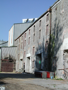
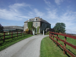
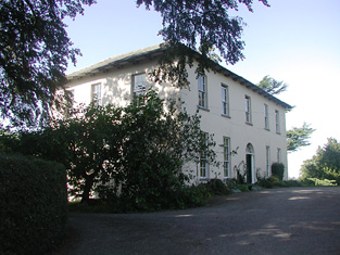
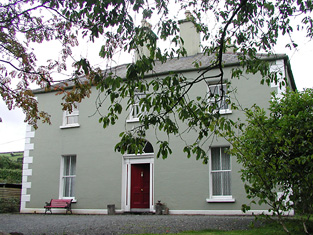
| Smithville [Yewstown House] | In 1840 the Ordnance Survey Name Books refer to Smithville "a commodious dwelling house", the residence of Mr. Boucher, though Peter Homes is mentioned as the proprietor. At the time of Griffith's Valuation, Aquilla Smith, MD, was leasing a property from the Holmes estate valued at £38. In addition Smith was leasing another property, valued at £15, to the Nenagh Poor Law Guardians, for use as an auxiliary workhouse. By the publication of the 25-inch Ordnance Survey map of the 1890s, a more substantial house at the site has become known as Yewston House. The building at the site now is known as The Manor and is in use as a nursing home. |
![Photo of Smithville [Yewstown House]](https://landedestates.ie/storage/img/orig/2843.jpg)
|
| Annebrook House | The Ordnance Survey Name Books reported in 1840 that Annebrook House was the residence of Henry Young but that P. Holmes was the proprietor. At the time of Griffith's Valuation, Henry Young was leasing the property, valued at £10+, from the Holmes estate. Buildings are still extant at the site including the remains of substanial farm buildings associated with the farm which is mentioned in the 1840s. |

|