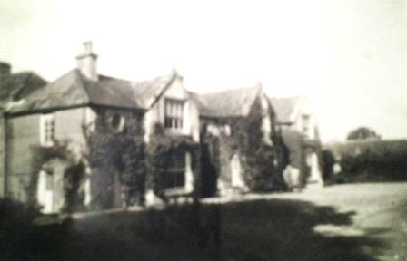
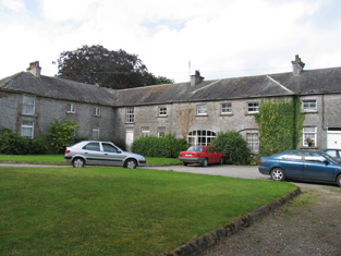
Finnoe
Houses within 5km of this house
Displaying 19 houses.
Houses within 5km of Finnoe
Displaying 19 houses.
| House name | Description | |
|---|---|---|
| Bellpark | Occupied by T. Robinson in 1837. The Ordnance Survey Name Books record Eyre C. Baldwin as the proprietor in 1840. It was occupied by Thomas Goold in the early 1850s. Goold held the house valued at £17+ with 116 acres from Denis Leonard and was the tenant at the time of house of the 1852 sale. A house is still extant at the site. | |
| Bellgrove | The home of the Leonard family in the first half of the 19th century. The Ordnance Survey Name Books refer to Geoffrey Leonard as the proprietor in 1840 but note that the house was not inhabited. It was held by Denis Leonard in fee at the time of Griffith's Valuation when the buildings were valued at £25.10 shillings. This house was unoccupied at the time of the 1852 sale. It appears to have been bought by Hyacinth Richard Daly, who advertised it for sale again in 1863. The sale rental states that the dwelling house was in "an unfinished state". Bellgrove no longer exists. | |
| Ormond Cottage | Ormond Cottage was the residence of Samuel Waller in 1837 and is also noted in the Ordnance Survey Name Books which describe it as "a neat cottage". In the early 1850s he held it in fee and the buildings were valued at £15.10 shillings. It was included in the sale of 1856 sale. A building is still located at this site. | |
| Ballinderry | Occupied by the Saunders family from at least the 1770s. Owen Saunders was resident in 1814. He was related to the Sadleirs of Ballinderry. Lewis records Thomas Sadlier junior as the proprietor of Ballinderry "on which a house was about to be erected". Thomas Sadlier held the property in fee at the time of Griffith's Valuation when the buildings were valued at £29. At the time of the Saunders sale in 1877 this house was described as modern and substanial and "approached by a noble avenue lined with beech trees". It was in the owner's possession. Occupied by William J. Russell in 1906. This house is still a residence. | |
| Killavalla | Lewis records Killavalla as the seat of R. Johnston Stoney. The Ordnance Survey Name Books refer to the house in this townland as "Honeywood House, the residence of Robert Johnstone Stoney, very commodious with convenient offices attached". Stoney's representatives held the property valued at £16+ from the representatives of Stephen Egan at the time of Griffith's Valuation. It later became the seat of the Saunders family. This house no longer exists. |
|
| Greyfort Cottage [later Greyfort House] | The Stoneys were residing at Greyfort from at least the 1770s as recorded by Taylor and Skinner and also by Wilson in 1786. A house known as Greyfort Cottage was marked on the first edition Ordnance Survey map at this location and is also mentioned in the Ordnance Survey Name Books which refers to it as "a good dwelling house, the residence of Henry Owen Saunders". On later maps a different building in the townland is known as Greyfort House. Biggs A. Stoney was living at Grey-fort, Borrisokane, in 1814 and Saunders is recorded as the proprietor by Lewis. William Gray was the occupier of a house in Greyfort townland, valued at £12+, at the time of Griffith's Valuation and held from Henry O. Saunders. Thomas R. Grey of Greyfort House owned 500 acres in the 1870s. Buildings are still extant at this site. | |
| Ballyrickard House | Ballyrickard may possibly be the house known as Lettyville on the Taylor and Skinner map from the 1770s. Leet records Daniel Falkener as resident at Ballyrickard in 1814 and Lewis records N. Falkiner as the proprietor. The Ordnance Survey Name Books refer to Ballyrickard as "a commodious house", the residence of Nathaniel Falkiner. In the early 1850s Addison Hone was the occupier holding the property from Richard H. Falkiner. The buildings were valued at £15. This 18th century house is still extant and occupied. |

|
| Congor | Occupied by F. Falkiner in 1837 and described by the Ordnance Survey Name Books as "the commodious residence of Nicholas Biddulph" in 1840. It was still occupied by him at the time of Griffith's Valuation when the house was valued at £20. Nicholas Biddulph was still resident in the mid 1870s when he is recorded as owning 74 acres in county Tipperary. A building is still located at this site. | |
| Mount Falcon | Bence Jones writes that this house was built in 1720 by Richard Falkiner. It was the seat of the Falkiner family in the 18th and 19th centuries. The Ordnance Survey Name Books refer to it as the seat of Richard Fitzpatrick Falkiner (a minor) in 1840 and that it was occupied by Obediah Holan. At the time of Griffith's Valuation the house was valued at £15. It is still extant. |

|
| Kyle Park | Marked on the first edition Ordnance Survey map Kyle Park was occupied by Thomas G. Stoney at the time of Griffith's Valuation and held by him in fee. It was valued at £39. The Ordnance Survey Name Books had described it as " a new and commodious house built and occupied by T.G. Stoney". The Stoneys still lived at Kyle Park in the 1870s. This house is still extant. |
|
| Arranhill | Arranhill was a Stoney home in the late 18th century. Thomas Stoney was resident in 1814 and Thomas George Stoney in 1837. In 1840 the Ordnance Survey Name Books report that "it suffered considerable damage during the storm of 6 and 7 January, 1839. It is occupied at present by Mr. Skelly, land steward to George Walpole, Brusna Mills, Roscrea". The Name Books also note the Marquis of Ormond as the proprietor. Thomas G. Stoney was the occupier in the early 1850s holding the property from the representatives of T.P. Firman. The buildings were valued at £23.10 shillings. This house is described as "in ruins" on the 25-inch Ordnance Survey map of the 1890s and some of these ruins remain. | |
| Oldcourt | John Brereton of Oldcourt was the second son of John Brereton of Rathurles and his wife, Margaret Watson. He had a son,John, born 1817. The Ordnance Survey Name Books refer to it as his property in 1840 but mention that it was "a commodious house" occupied by his land steward. John Brereton held Oldcourt in fee at the time of Griffith's Valuation when the house was valued at £12. A building is still extant at this site. | |
| Rodeen | A Falkiner residence from at least 1837. It was the home of Joseph Falkiner who held the property in fee. He was one of the eleven sons of the Reverend R.D. Falkiner of Mount Falcon. The house was valued at £22. It was advertised for sale in July 1860, Mrs Anne Falkiner and Richard J. Falkiner were the tenants. The house came on the market again in May 1867, part of the 105 acres for sale at Rodeen, the estate of Octavius La Touche. This house is still in use as a residence. |

|
| Bushy Park | Bushy Park was the home of Thomas Towers in 1814 and in 1837. In 1840, the Ordnance Survey Name Books refer to it as " a comfortable house, the residence of Thomas Towers" and also include reference to a letter written by Mr. Towers in which he expressed the wish that the house would revert to the name Shesharaghmore house though this does not seem to have happened. Sarah Cambie was occupying the house valued at £15 and held from Thomas Towers in the mid 19th century. David Clarke is described as "of Bushy Park, Borrisokane and Macclesfield" in the 1870s. Still valued at £15 this house was held by the representatives of David Clarke in 1906. A building is still extant at the site. | |
| Fort Nisbitt | Robert Nesbett was resident at Fort Nesbett in 1814. The Ordnance Survey Name Books also mention him in 1839 though they refer to Thomas Towers as the proprietor of the townland. In the early 1850s, Thomas O'Brien was the occupier, holding the property from the Reverend James Nesbitt. The buildings were valued at £12.15 shillings. A building is still located at this site. | |
| Carney Castle | Daniel Grace traces the occupation of Castle Carney by members of the Grace, Chissers, Saunders, Hunt, Gamble and Nugent families. He writes that in 1797 Catherine Nugent married Arthur French, a Dublin attorney, and that their son, Arthur, came to live in his new house in the 1830s. Lewis describes Carney Castle in 1837 as the residence of A. French "a handsome modern house on part of the site of the ancient castle, now in ruins, and formerly the residence of the Grace family". At the time of Griffith's Valuation Eliza French held the house valued at £17 and 160 acres in fee. In the possession of the Walpole family in 1866. The Falkiner sale rental of June 1873 refers to the deed of partition of the lands of Carney Castle in 1862 and that the Castle Division was alloted to Mrs Eliza ffrench for life. The rental describes Mrs ffrench as "deceased" and that her interest was for sale by her four daughters. | |
| Cloghprior House | The home of the Woodward family until sold to Edwin Cuthbert in 1844. The Ordnance Survey Name Books describes it as "at present in a state of very bad repair, but bears marks of ancient splendour". Held by Edwin Cuthbert in fee at the time of Griffith's Valuation and valued at £5.5 shillings. Daniel Grace writes that it was renovated by John Flower circa 1860s and leased to John Talbot. The Talbot family continued to reside at Cloghprior until the early 20th century. | |
| Woodpark (Cloghprior) | In 1841 the Ordnance Survey Name books refer to Woodpark as "a new house, the occasional residence of George Waller". At the time of Griffith's Valuation, it was held in fee by William Waller and valued at £7. Woodpark is now a ruin. | |
| Fort Henry [Greyfort Cottage] Borrisokane | In 1840, the Ordnance Survey Name Books refer to "Fort Henry, a commodious house, the residence of Henry Ely" in the townland of Greyfort, parish of Borrisokane. At the time of Griffith's Valuation, Henry Ely was leasing a property valued at almost £5 from the Saunders estate in this townland. This may refer to the property shown on the 1st edition Ordnance Survey map as Greyfort House. On the later 25-inch map of the 1890s it is known as Greyfort Cottage. A house is still extant at the site. |