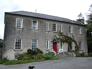
Sopwell Hall
Houses within 5km of this house
Displaying 20 houses.
Houses within 5km of Sopwell Hall
Displaying 20 houses.
| House name | Description | |
|---|---|---|
| Knockanacree Wood House | A house valued at £17+, occupied by Hawtrey Andrews and held from the Reverend Frederick F. Trench in the mid 19th century. Walford states that Hawtrey Andrews was the second son of Maunsell Andrews of Rathanny. This house is now demolished. | |
| Lisbryan | Lisbrien or Lisbryan, near Ballingarry, was occupied by Faulkner Esq in the 1770s and 1780s. Sir Robert Waller Baronet was occupying this house in 1814. Lewis records T. Bunbury as the proprietor in 1837. The Ordnance Survey Name Books, also refer to it as his residence, "a very extensive building of the modern style". Thomas Bunbury held the property from Lord Ashtown at the time of Griffith's Valuation when the buildings were valued at £40+. Lisbryan is still extant. |

|
| Ballymona | Ralph Smith was resident at Ballymona in 1837 and in the early 1850s. The Ordnance Survey Name Books refer to the house as " a plain modern building" in 1841. Smyth held the property from Lord Ashtown and the buildings were valued at £25. This house is now a ruin. | |
| Fairyhill | Fairyhill was the home of William Henry Cox in 1837. The Ordnance Survey Name Books describe it as "a large mansion house, the residence of Mr. Cocks [sic]" in 1841. It was occupied by Ellen Robinson in the early 1850s, when the house was valued at £19 and held from Lord Ashtown. Valued at £16 in 1906 and held by George W. Robinson. This house is still in use as a residence. |

|
| South Park | In the 1770s Abbot Esq was residing at Rahanane close to Ballingarry. Wilson, writing in 1786, also refers to Rahanane as the seat of Mr. Abbott. The house is named South Park on the 1st edition Ordnance Survey map and was the home of a branch of the Atkinson family, occupied by Anthony Atkinson in 1814 and by C. Atkinson in 1837. Charles Atkinson held the property from Lord Ashtown at the time of Griffith's Valuation when the house was valued at £22. The estate of Edward Evans of Southpark, 174 acres in the barony of Lower Ormond, was advertised for sale in December 1859. South Park is still extant. |
|
| Ballingarry | Situated just north of Ballingarry castle Ballingarry House was built circa 1820. Lewis records Marmaduke Thompson as resident at Ballingarry Castle in 1837 as does the Ordnance Survey Name Books in 1841 though they refer to Lord Ashtown as the proprietor. The Thompson interest in Ballingarry and Ballinahinch was for sale in June 1850. Henry Trench was the occupier in the early 1850s holding the property form Lord Ashtown. Ballingarry House is still extant and occupied. |
|
| Killavalla | Lewis records Killavalla as the seat of R. Johnston Stoney. The Ordnance Survey Name Books refer to the house in this townland as "Honeywood House, the residence of Robert Johnstone Stoney, very commodious with convenient offices attached". Stoney's representatives held the property valued at £16+ from the representatives of Stephen Egan at the time of Griffith's Valuation. It later became the seat of the Saunders family. This house no longer exists. |
|
| Greyfort Cottage [later Greyfort House] | The Stoneys were residing at Greyfort from at least the 1770s as recorded by Taylor and Skinner and also by Wilson in 1786. A house known as Greyfort Cottage was marked on the first edition Ordnance Survey map at this location and is also mentioned in the Ordnance Survey Name Books which refers to it as "a good dwelling house, the residence of Henry Owen Saunders". On later maps a different building in the townland is known as Greyfort House. Biggs A. Stoney was living at Grey-fort, Borrisokane, in 1814 and Saunders is recorded as the proprietor by Lewis. William Gray was the occupier of a house in Greyfort townland, valued at £12+, at the time of Griffith's Valuation and held from Henry O. Saunders. Thomas R. Grey of Greyfort House owned 500 acres in the 1870s. Buildings are still extant at this site. | |
| Clifton | Lewis records Clifton as the seat of Captain Sheppard. The Ordnance Survey Name Books refer to it as "a modern building, the residence of Capt. Sheppard" in 1841. Arthur Sheppard [?] was the occupier at the time of Griffith's Valuation. He held the property from Thomas Pyke and the buildings were valued at £14.10 shillings. The National Inventory of Architectural Heritage records the present house as dating from 1868. |
|
| Behamore | The Reverend Thomas Hawkshaw was resident here in 1814 and Benjamin Hawkshaw in 1837. The Ordnance Survey Name Books also note it as his residence, describing Behamore as "a commodious house". James Fleetwood was the occupier in the early 1850s holding the property from Lord Dunalley, it was valued at £13+. A building is still located at this site. | |
| Ballynavin | According to the National Inventory of Architectural Heritage the origins of this building date back to the mid 17th century. Ballynavin was a Robinson home in the 19th century, occupied by Mrs Robinson in 1837 and by Reverend Robert Robinson in the early 1850s. He held the property in fee and the buildings were valued at £18. Robert Robinson lived at Ballynavin in the 1870s. The house is still in use as a residence. |

|
| Riversdale | This house was built after the first Ordnance Survey. At the time of Griffith's Valuation Thomas S. D. Robinson is recorded as the occupier of a house valued at £15 in the townland of Ballynavin. He held the property in fee. Thomas S.D. Robinson was still living at Riversdale in the 1870s. This house continues to be used as a residence. |

|
| Cloghkeating | The home of Augustus Robinson from the 1830s. The Ordnance Survey Name Books refer to Cloghkeating as "a large new house" in 1841. At the time of Griffith's Valuation Augustus Robinson held the property in fee and the buildings were valued at £19. Augustus Robinson of Cloghkeating owned 231 acres in the 1870s. This house is still in use as a residence. |

|
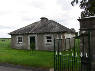
| Modreeny House | In 1786 Wilson refers to "Moderenny" as the seat of Sir Amyrald Dancer. The Ordnance Survey Name Books refer to the house as Eminisky House in 1841 but it is marked on the first edition map as Modreeny House and was the home of the Dancer family. It was replaced by a new house circa 1920s. The outbuildings, gates and gatelodge of the original house still remain. At the time of Griffith's Valuation Sir Thomas B. Dancer held this property in fee. The buildings were valued at £21. Hussey gives Modreeny House as the address of Sir Thomas Dancer in 1878. |
|
| Modreeny | Lewis records W. H. Head as the proprietor of Modreeny House in 1837. He was still resident at the time of Griffith's Valuation and held the house valued at £35 in fee. Burke's ''Landed Gentry of Ireland'' (1904) records William Henry Head's father as "of Modreeny House". In 1906 the representatives of George Whitfield were the occupiers and the house was valued at £36.10 shillings. George Whitfield of Modreeny owned 443 acres in the 1870s. In 1890 his daughter Kathleen married Sir Francis Osborne, Baronet. This house was bought by Donald Swan in 1965 and Charlie Swan, champion jockey, was born at Modreeny in 1968. |
|
| Coorevin | Lewis records Cooreavan as the property of R. Hall in 1837. In 1840 the Ordnance Survey Name Books indicate that it was occupied by "Mr Gorey Baker, Burresokane". Jeremiah P[ierce] Scully was the occupier at the time of Griffith's Valuation, holding the property from the representatives of Robert Hall. The buildings were valued at £11. A building is still located at this site. | |
| Uskane | Carrol Esq was resident at "Iscane" in the 1770s and 1780s. In 1837 R. Hall was the proprietor of Uskane House. In 1840 the Ordnance Survey Name Books note it as "a good dwelling house, the residence of Mr. Kent". It was held by the representatives of Robert Hall in fee at the time of Griffith's Valuation when the house was valued at £8. This house is still in use as a residence. |
|
| Fort Nisbitt | Robert Nesbett was resident at Fort Nesbett in 1814. The Ordnance Survey Name Books also mention him in 1839 though they refer to Thomas Towers as the proprietor of the townland. In the early 1850s, Thomas O'Brien was the occupier, holding the property from the Reverend James Nesbitt. The buildings were valued at £12.15 shillings. A building is still located at this site. | |
| Castle Sheppard | The Sheppards were living here from at least the 1770s.In 1786 Wilson refers to Castle Sheppard as the seat of "Mr. Shepherd". It was the home of a junior branch of the family. William Sheppard was resident in 1837 and in the early 1850s when the house was valued at £26 and held from Lord Ashtown. William died at Castle Sheppard in 1852 without heirs and both his brothers died unmarried in India. Valued at £18 in 1906 and occupied by the Honourable Cosby G. Trench. This house is now a ruin. | |
| Fort Henry [Greyfort Cottage] Borrisokane | In 1840, the Ordnance Survey Name Books refer to "Fort Henry, a commodious house, the residence of Henry Ely" in the townland of Greyfort, parish of Borrisokane. At the time of Griffith's Valuation, Henry Ely was leasing a property valued at almost £5 from the Saunders estate in this townland. This may refer to the property shown on the 1st edition Ordnance Survey map as Greyfort House. On the later 25-inch map of the 1890s it is known as Greyfort Cottage. A house is still extant at the site. |