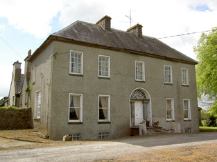
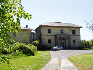
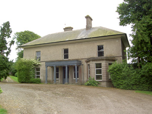
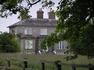
Langley Lodge
Houses within 10km of this house
Displaying 34 houses.
Houses within 10km of Langley Lodge
Displaying 34 houses.
| House name | Description | |
|---|---|---|
| Harley Park | The Poe residence at this location in the 18th century was known as Rosenaharly as mentioned by Wilson in 1786. The seat of the Poe family, occupied by James Poe in 1814 and by J.P. Poe in 1837. James Purefoy Poe was still resident in the mid 19th century, holding the property in fee. The buildings were valued at £41.10 shillings. The Poes were still resident in the early 20th century and this house is still a residence. |
|
| Ballyphilip | The seat of the Going family in the 18th and 19th centuries, W. and A. Going were resident in 1814 and Ambrose Going held the property in fee at the time of Griffith's Valuation. The buildings were valued at £30.15 shillings. This house was held by the representatives of B.F. Going in 1906. Buildings are still extant at the site. | |
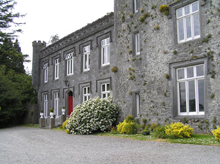
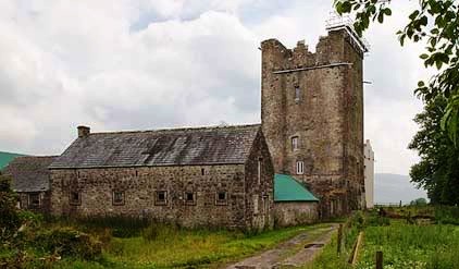
| Lisnamrock Castle | The Langleys were resident here from the 18th century. Wilson, writing in 1786, refers to Lisnarock as the seat of Mr Langley. Henry Langley was the occupier in the mid 19th century, holding the property in fee. The buildings were valued at £11.10 shillings. Held by George Langley in 1906. Buildings still exist at this location. | |
| Glenview | Glenview was occupied by the Reverend Edmund Prendergast in the early 1850s. He held the house valued at £18.15 shillings from Matthew Prendergast. In the early 20th century the house was altered and extended by a religious order who set up a school. |
|
| Wilford | Wilford was the residence Butler Esq in the 1770s and 1780s and of Mr Richard Blackmore in 1814. In the early 1850s it was occupied by John Blackmore, who held the property valued at £11+ from William P. Barker with 128 acres. The house is labelled Wilford House on the 1st edition Ordnance Survey map but as Shangarry House on the 25-inch edition of the 1890s. It is now a ruin. | |
| Willmount | Occupied in 1814 by Robert Lane and by Hampden Lane in the early 1850s, when the house was valued at £17 and held from William P. Barker. This house is still an occupied residence. |
|
| Kilburry | The home of Jeremiah Meagher in 1814 and of Robert Maher in the mid 19th century. He held the house valued at £16.15 shillings from William Beasley. Buildings are still located at this site. | |
| Roan | Dennis Duan was resident here in 1814 and Robert Purcell in 1814. He held the property valued at £18.15 shillings from Matthew Jacob. This house had later associations with the Bianconi family and is still a family home. |
|
| Ballylanigan (Cramer) | [Thomas Pennefather is recorded as resident at Ballylanigan (Pennefather?) in 1814]. Lewis refers to the Cramer family of Ballylanigan. At the time of Griffith's Valuation Ballylanigan (Cramer) was occupied by Thomas Sexton and held from Mrs Catherine Reeves. The buildings were valued at £17+. This house still exists. | |
| Hilton | This house is not marked on the first Ordnance Survey map. The National Inventory of Architectural Heritage dates the house circa 1850. At the time of Griffith's Valuation the representatives of J. Stephens held most of this townland from the Pennefathers. The home of the Grant family from at least the 1870s. Slater refers to it as the seat of Colonel G. Fox Grant in 1894. Valued at £22+ in 1906 and occupied by Joseph B. Grant. It is still extant. in 2015 it was offered for sale. |

|
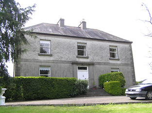
| Ballywalter | Occupied in the early 1850s by John Doherty, valued at £12 and held from the [Reverend] John Burdett, uncle of Arthur Burdett. | |
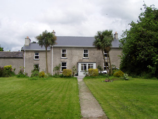
| Gurteen | Thomas Bryan was the proprietor of Gorteen, Callan, in 1814 and Lewis records Gurteen as the home of the Reverend W. O'Brien [Bryan?]. The Reverend William Bryan held the property in fee at the time of Griffith's Valuation when the buildings were valued at £10.15 shillings. Members of the Bryan family were still resident at Gurteen in the 1980s. Buildings still exist at this location. | |
| Killaghy | This is an old tower house which has been altered and remodelled. In the 1770s and 1780s it was the home of Greene Despard Esq. In 1837 Lewis refers to W. Despard as the proprietor of Killaghy ‘which was the residence of Baron Tobin, and was taken by Cromwell, who gave it to a Col. Green, from whom it has descended to its present proprietor’. Griffith's Valuation also records William Despard as the occupier. He held the house valued at £23 from Sir Riggs Falkiner. Bence Jones writes that Killaghy passed from the Despards to the Wrights by inheritance. Hubert H Fox of Killaghy Castle owned 321 acres in county Tipperary in the 1870s. In 1894 Slater refers to it as the seat of Miss M.A. Walpole. Killaghy has had a number of owners in the 20th century and continues to function as a country residence. For sale in 2010 see http://www.michaelhdaniels.com. |
|
| Mohober | Mohober was occupied by Scott Esq in the 1770s and 1780s. It was the home of the Cormick family in the 19th century. Richard Cormick was resident in the early 1850s holding the property from the Earl of Clonmel. The buildings were valued at £14.15 shillings. In the 1870s Daniel Cormack of Mohober owned 189 acres in county Tipperary. The sale rental of the interest of James P. Welply in the house and demesne of Mohober dated July 1868 records that the property was conveyed to Daniel Welply by the Encumbered Estates Commissioners in May 1856. The original lease dated 1766 was from William Cane to Mark Scott. The Cormac interest in this property was advertised for sale in June 1876. Buildings are still extant at this site. | |
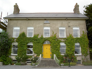
| Oakfield | A house occupied by Purefoy Poe in 1814 and by the Reverend Daniel Corcoran in the early 1850s, when it was held from the representatives of R. Constable junior and valued at £15.10 shillings. The Ordnance Survey Name Books mention that there was a garden, fir plantation and planted ornamental ground attached to Oakfield House. Renovated in the 1930s it is still extant and inhabited. |
|
| Cloneen House | The home of the Meagher family, occupied by William Meagher in 1814 and by Henry C. Meagher in 1850. The property was held from the Earl of Clare and was valued at £18. This house is still occupied. |
|
| Lismortagh | Matthew N. Sankey was residing at Lismortagh in 1814 and John Millett in 1850. Millet held the property from the representatives of William Burgess and the buildings were valued at £17.15 shillings. This 18th century house is still a fine residence. |
|
| Mortlestown Castle | Captain James G. Jacob was the occupant of Mortlestown Castle in 1814. By the time of Griffith's Valuation Thomas P. Lloyd was resident holding the property from Robert Jacob. The house was valued at £29. Buildings are still located at this site. | |
| Bannixtown | A Clutterbuck home from at least the 1770s, Richard Clutterbuck was resident at Bannixtown in 1814. On the first Ordnance Survey map circa 1838 Bannixtown house is recorded as "in ruins". In 1840, though, the Ordnance Survey Name Books mention Bannixtown as a large farmhouse. The 25-inch map shows a building labelled "Bannixtown House" at the same site. A house valued at £19 was occupied by John Shea at Bannixtown in the early 1850s and held from the representatives of Thomas Clutterbuck. John Shea of Bannixtown owned 254 acres in the 1870s. | |
| Grove | A mid 18th century house which was altered in the 1830s. Grove was the seat of the Barton family, mentioned by Wilson as the seat of William Barton in 1786. It was occupied in 1814 by Thomas Barton and by William Barton in 1837. The Ordnance Survey Name Books describe it as "a very large dwelling house with extensive offices" in 1840. At the time of Griffith's Valuation, William Barton held Grove in fee and it was valued at £69. Grove remained in the possession of the Barton family until the mid 20th century when it passed to the Ponsonby family. This house is still extant and occupied. |
|
| Kyle | A house occupied by Matthew R. Millett at the time of Griffith's Valuation, valued at £10 and held from Colonel W. Palliser. | |
| Ballyrichard | The Ordnance Survey Name Books describe Ballyrichard as "a good farmer's hosue with offices and garden" in 1840. The house, valued at £12.18 shillings, was occupied by Matthew Hughes and held from Colonel W. Palliser at the time of Griffith's Valuation. Richard H. Hughes of Ballyrichard owned 597 acres in the 1870s. A substantial farm is still extant at the site. | |
| Peppardstown | The home of members of the Henderson family in 1814 and in 1850 when Samuel Henderson held a house valued at £10.14 shillings from Matthew Jacob at Peppardstown. In the mid 1870s Jerome James Guiry was living at Peppardstown, Fethard and the Guiry family were still resident in the early 21st century. The National Inventory of Architectural Heritage dates the present Peppardstown house from circa 1870. Beatrice P. Saunders was occupying the mansion house at Peppardstown in 1906. |
|
| Coolmore | The seat of the Sankey family in the 18th and 19th centuries, Coolmore was recorded by Wilson as the seat of Mr. Sankey in 1786. It was occupied by John Butler in 1814, by Matthew Villiers Sankey in 1837 and by Jacob Sankey in 1850. He held the property in fee and the buildings were valued at £37.15 shillings. In the second half of the 20th century Coolmore became a world famous stud for the breeding of race horses. The stud was set up in the late 1960s by Tim Vigors and continued by Vincent O'Brien, Robert Sangster and John Magnier. |
|
| St Johnstown | St Johnstown originally belonged to Matthew Jacob, whose only daughter and heir married Richard Pennefather of New Park in 1782. Wilson refers to it as the seat of Mr. Jacob in 1786 but their second son Matthew J. Pennefather was resident at St Johnstown in 1814. In 1837 Lewis records St Johnstown Castle as "consisting of a high square tower in good preservation, [it] is the property of James Millet Esq who has a modern house in its immediate vicinity". The buildings were valued at £31+ in the early 1850s, James Millet was still the occupier holding the property from Stephen C. Moore. | |
| Ballydavid | In the mid 19th century Patrick Murphy held a house valued at £10 from Thomas Power in the townland of Ballydavid. | |
| Hilton | A house built after the publication of the 1st Ordnance Survey map. The home of the Grant family from at least the 1870s. Slater refers to it as the seat of Colonel G. Fox Grant in 1894. Valued at £22+ in 1906 and occupied by Joseph B. Grant. It is still extant. In 2015 it was offered for sale. |
|
| Cloonyhea | A house valued at £11+ was occupied by Thomas Mansfield at Cloonyhea in the mid 19th century. It was held from John Bradshaw. A small house is marked on the first edition Ordnance Survey map at this location. It had increased considerably in size on later maps, still extant. | |
| Knockkelly | In the mid 19th century Richard Crane held a house valued at £12+ from William Barton in the townland of Knockkelly. This appears to be the house marked as Knockkelly house on the first edition Ordnance Survey map. | |
| Cloran | A house valued at £10. 11 shillings at the time of Griffith's Valuation, occupied by Miss Mary Kelly and held from the Earl of Clare with 224 acres. A building is still located at this site. | |
| Ballinard Castle | In 1894 Slater refers to Ballinard Castle as the residence of William Tennant. At the time of Griffith's Valuation, John Lindsay owned land in the townland of Friarsgrange, parish of Coolmundry, in which Ballinard Castle is situated. It appears that, in the nineteenth century, a house was built adjoining the original tower house as, in 1840, the Ordnance Survey Name Books refer to Ballinard Castle, a gentleman's seat in the townland of Friarsgrange. Information in the Woodstock Museum, Ontario, Canada, indicates that the building was owned by the Lindsay family until 1926. The building is still extant. |
|
| Coolquill Castle | In 1786 Wilson refers to Coolquill as the seat of Mr. Gahan. The property is labelled "Coolquill Castle" on the 1st edition Ordnance Survey map and indicates that it was built on to a tower house. Coolquill was held in fee by Colonel Palliser in the mid 19th century. He was married to Anne Glenstanes. The castle was valued at £5. The castle ruin and other buildings are still extant at the site. | |
| Brookhill House | In 1786 Wilson refers to Brookhill as the seat of Mr. Lowe. The 1st edition Ordnance Survey map shows Brookhill house, "in ruins", in Farranshea townland, parish of Peppardstown. An old manor house, also in ruins, is shown as well. The Ordnance Survey Name Books, in 1840, describe the site as "two large houses, one having its eastern end and the other, its eastern side, joining the ruins of the Old Manor House". At the time of Griffiths' Valuation, the townland was in the possession of the Hackett estate and the houses are described as "in ruins". The ruins are not shown on the later 25-inch map of the 1890s. | |
| Venter Fair | The Ordnance Survey Name Books refer to this house in the townland of Clashduff, parish of Ballingarry as "Venture Fair" and note the existence there of coal mines of the same name. At the time of Griffith's Valuation, it was leased by Mrs. Mary O'Sullivan from the Langley estate and valued at almost £10. A house is still extant at the site. |