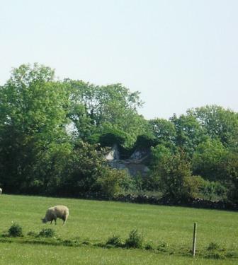
Tully (Moycarn)
Houses within 10km of this house
Displaying 35 houses.
Houses within 10km of Tully (Moycarn)
Displaying 35 houses.
| House name | Description | |
|---|---|---|
| Clonfert Palace | Clonfert Palace was built in the late 17th century and altered in the 18th century. It was the residence of the Church of Ireland bishop of Clonfert until 1836 when that diocese was amalgamated with Killaloe. At the time of Griffith's Valuation, John E. Trench was leasing the property valued at £20 from the Ecclesiastical Commissioners in the townland of Clonfert Demesne, barony of Longford, county Galway. In 1906 it was in the ownership of Charles O'Hara Trench. Later occupied by the British fascist leader, Oswald Mosley. It was damaged by fire in 1954 and has been derelict since. |
|
| Clonfert Cottage | In 1855, a house valued at £8 and belonging to the representatives of Robert Seymour, was leased by James Buchanan. Slater refers to "Clonfert Cottage" as the residence of Robert Seymour in 1846. On the 25-inch maps of 1890s the property at this site is labelled "Constabulary Barracks". | |
| Kylemore Dairy | Allan Pollok held a property valued at £7 together with over 400 acres in the townland of Kylemore, parish of Clonfert, barony of Longford in 1856. On the 25-inch Ordnance survey map of the 1890s there is a property labelled Kylemore Dairy in this townland. Parts of the farm buildings remain at the site. | |
| Lismany/Lismanny | Allan Pollok's estate was centred on the property at Lismany. In 1856 the buildings there were valued at £10. In 1906 Lismanny was owned by the representatives of John Pollok. It was valued at £90. It was sold by the Pollok family in 1924 and demolished some years later. Only the cellar of the house together with the ruins of an extensive range of estate buildings now remains at Lismanny. However both gatelodges and several other estate houses are still occupied. |
|
| Kellysgrove | Wilson refers to Kellysgrove as the seat of Mr. Kelly in 1786. In 1837 Lewis recorded Kellysgrove as the seat of W. Kelly. The house was occupied by Charles Denis Kelly at the time of the Encumbered Estates court sale in December 1850. At the time of Griffith's Valuation, the house at Kellysgrove, parish of Clontuskert, valued at £20, was leased by Robert St. George from the Earl of Clancarty's estate. The original house is no longer extant. |
|
| Craig's Hotel | John H. Craig was leasing a property valued at £65 at Back, parish of Kilcloony, barony of Clonmacnowen from the Clancarty estate at the time of Griffith's Valuation. He was running this property as a hotel. In Slater's Commerical Directory, 1846, Craig's hotel was located on the Main Street in Ballinasloe. The Royal Mail car called there on its way from Galway to Dublin. | |
| Brackernagh Lodge | A house valued at £18 at Brackernagh, parish of Kilcloony, barony of Clonmacnowen, was being leased by the Clancarty estate to Miss L. Trench at the time of Griffith's Valuation. This is most likely the house which appears on the 6-inch OS map as Brackernagh Lodge. The National Inventory of Architectural Heritage notes that it was previously known as Mount Catherine. It is still extant and occupied. |
|
| Cleaghmore | Andrew Montgomery was leasing a house valued at £13 from the Clancarty estate at Cleaghmore, parish of Kilcloony, barony of Clonmacnowen, at the time of Griffith's Valuation. | |
| Cleaghmore Villa | A vacant house, valued at £11 and part of the property of Norman Ashe, was located at Cleaghmore, parish of Kilcloony, barony of Clonmacnowen at the time of Griffith's Valuation. This is possibly the house shown on the 25-inch Ordnance Survey map of the 1890s as Cleaghmore Villa which is still extant. |
|
| Cleaghmore B & C | At the time of Griffith's Valuation, the Clancarty estate was leasing two houses in this townland to members of the Le Poer Trench family, one (Cleaghmore B) valued at £23 and the other Cleaghmore C) at £21. They were leased by Mrs. Le Poer Trench and Robert Le Poer Trench respectively. | |
| Beechlawn House (Kilcloony) | John Craig was leasing a house valued at £10 to Geoffrey Prendergast at Pollboy, parish of Kilcloony, at the time of Griffith's Valuation. On the 1st edition Ordnance Survey map the building at this site is labelled schoolhouse. However, a larger building of differing proportions is shown on the later 25-inch Map of the 1890s. The property at this site is named Beechlawn House by the National Inventory of Architectural Heritage. |
|
| Fortwilliam | At the time of Griffith's Valuation William Lancaster was leasing a property valued at £25 from the Trench estate at Ardcarn, barony of Moycarn. At the same time Thomas Lancaster was leasing a property to Capt. James Bell. In 1786 Wilson refers to Fortwilliam as the seat of Mr. Lancaster. A modern house occupies the site at Fortwilliam but there are remains of yard buildings and a walled garden. |
|
| Thomastown Park | Built in the 18th century and home of the Naghten family for over 200 years, valued at £35 in the 1850s. Wilson refers to it as the seat of Mr. Naghten in 1786. In 1894 Slater mentions Thomastown park as the seat of Mrs. Naghten. It is no longer extant. | |
| Mounthussey | The home of the Hussey Walsh family, valued at £4 at the time of Griffith's Valuation. The later 25-inch map of the 1890s shows a much larger house at Moynure. A house still exists on the site. | |
| Johnstown | Built circa 1782 by Colonel John Dillon and held on a lease in perpetuity from the Incorporated Society for Promoting English Protestant Schools in Ireland. The Ordnance Survey Name Books refer to this fine residence, occupied by D. Kelly. The Dillons were in residence again by the time of Griffith's Valuation. It became the home of the Kelly family in the early 1870s until the late 1920s. Demolished by the Land Commission, only the entrance gates still remain. | |
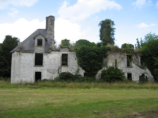
| Mount Florence | This house originally known as the 'Whitehouse' and later as 'Mount Florence' was the home of the O'Sullivan family from the mid 18th century. In 1883 it was sold to the Greene family from the Ballinasloe area. It is now a ruin. | |
| Esker | Occupied by W. Kelly in 1837. Bought by the Glennon family and occupied by them for most of the 20th century, still extant. |

|
| Ardkeenan | A Kelly home at the end of the 18th century which passed to the Cruise family following the marriage of Daniel John Cruise, grandson of Daniel Cruise of Cruise Lodge and Ann Kelly in 1820. Occupied by Edmond Naghten in the 1830s and by Timothy Connell at the time of Griffith's Valuation who purchased the property. | |
| Newcomen Castle | Newcomen residence in the 18th century. It is shown on the 1st edition Ordnance Survey map but only the site of the castle is recorded on the later 25-inch map of the 1890s. | |
| Bellfield Cottage | Bellfield Cottage, valued at £6, was the residence of Michael E. Murphy at the time of Griffith's Valuation. A house is still extant at the site. | |
| Ardcarn (Lancaster) | Thomas Lancaster was leasing this property to Capt. James Bell at the time of Griffith's Valuation. Lewis records it as the residence of Capt. Bell in 1837. The house is still extant and occupied. |
|
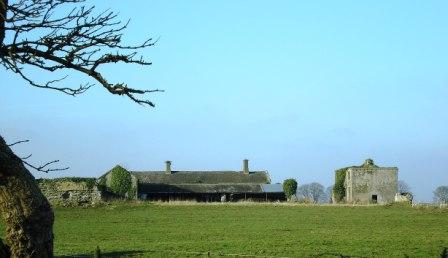
| Atticorra | Brabazon Sharpe was leasing a property valued £20, including a mill, to Patrick Harney. This property was situated at Atticora, barony of Moycarn. A mill is shown at this location on the 1st edition OS map. The ruins of the buildings are still visible at the site. |
|
| Birch Grove | At the time of Griffith's Valuation Thomas Brabazon was leasing a property valued at £10 at Beagh, barony of Moycarn, county Roscommon, to Ellen O'Shaughnessy. In 1837 Lewis records Birch Grove as the residence of J. O'Shaughnessy. Referred to as the residence of J.J. O'Shaughnessy in 1894. A house is still extant at the site. | |
| Castle Park House | William Kelly was occupying a house valued at £23, at Cuilleen, barony of Moycarn, at the time of Griffith's Valuation. It is described as "in ruins" on the 25-inch Ordnance Survey map of the 1890s. | |
| Kilgarve House | At the time of Griffith's Valuation, Joseph Potts was leasing the house known as Kilgarve, barony of Moycarn, valued at £28, from the Earl of Clancarty's estate. At the time of the first Ordnance Survey the house is not shown although buildings and woodland are indicated. On the later 25" map, Kilgarve House is marked. A house is still extant at the site. | |
| Sralea House | At the time of Griffiths Valuation, Thomas Tully was leasing a property at Sralea, barony of Moycarn, valued at £8, to James Seyer. Modern buildings exist at the site. now. | |
| Lancaster House or Lancaster Park | Home of Thomas Lancaster in 1814. Thomas Lancaster was leasing a property at Suckfield, barony of Moycarn, valued at £17, to Robert H. Orr, at the time of Griffith's Valuation. Extensive remains of the stable block still exist at the site. In 1786 Wilson refers to "Suckville", the seat of Mr. Lynch. |
|
| Woodmount | The Reverend P.K. Egan in his book on Ballinasloe records the building of this house by Laughlen Kelly in 1783. At the time of Griffith's Valuation, John Kelly was leasing a property at Tonalig, barony of Moycarn, valued at £13, to James Delahunty. Both Lewis and Leet record this property as the residence of Hugh Kelly in 1837 and 1814 respectively. . Fr. Egan records that the Kellys sold the property around 1880 and emigrated to Australia. The property was in the possession of William and John Hynes in 1906. It is now in ruins. |
|
| Creagh Lodge | Francis Madden was leasing a property valued at £13 at Townparks, barony of Moycarn, from the Earl of Clancarty's estate in the 1850s. This may the property referred to on the 1st edition OS map as Creagh Lodge. | |
| Ballydangan | At the time of Griffith's Valuation James Thorngate was leasing a property valued at £6 at Ballydangan, barony of Moycarn, to James Miller. There is no house marked on 1st edition OS map at this location, though a police barracks is shown nearby. The building is no longer extant. | |
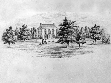
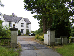
| Correen | At the time of Griffith's Valuation, William T. Potts was occupying the house at Correen, barony of Moycarn, valued at £22. The current house was built in the early 1830s but the Potts family were resident there prior to that as "Carrine" is recorded as their residence by Wilson in 1786. In 1837 the Ordnance Survey Field Name books describe Correen House as "a gentleman's place in very good repair on a demesne of over 300 acres". The building is still extant and occupied as a private residence. |
|
| Drumalagagh Cottage | At the time of Griffith's Valuation, George Harrison was leasing a property at Drumalagagh, barony of Moycarn, valued at £14, from Lieutenant Colonel Maberly. This seems to be the property known as Drumalagagh Cottage. This was earlier associated with the St. George family. In 1837 Lewis records Dromalga Cottage as owned by Sir R. St. George but the seat of Mr. Dexter. The Ordnance Survey Name books of the same year describe the property as "a gentleman's place in good repair". It appears to have been situated on the demesne known as Mount Equity, of about 770 acres. Buildings labelled "Mount Equity" appear on the 1st edition OS Map but not on subsequent editions. In the Encumbered Estates sale notice of 1852 Dromalgagh Cottage is described as unoccupied but formerly the residence of the late Mrs. Dexter. In 2009, this property was offered for sale. An eighteenth century mausoleum, dedicated to Henry St. George, is also located in this townland. |
|
| Faltia House | Daniel Mathers occupied Faltia House, barony of Moycarn, at the time of Griffith's Valuation, when it was valued at £9. It was part of a demesne of over 400 acres. The Ordnance Survey Field Name books of 1837 describe it as "a gentleman's place in good repair". | |
| Kilbegly House | At the time of Griffith's Valuation, John Dillon was leasing a house valued at £20 at Kilbegley, barony of Moycarn, to William Colohan. In 1837 Lewis records Kilbegley as the residence of B. Newcomen. In the same year it is recorded in the Ordnance Survey Name books as "a gentleman's place, two stories high, in good repair". The 25-inch map of the 1890s indicates alterations to the house. Only ruins remain at Kilbegly now. | |
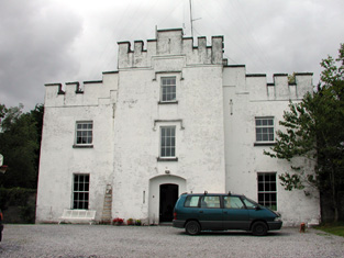
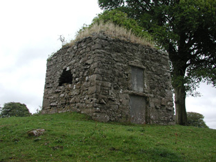
| Rathpeak House [Woodpark Lodge] | Owen Lynch was occupying the house at Rathpeak at the time of Griffith's Valuation when it was valued at £14. Lewis records Woodpark as his seat in 1837. This is also the property listed as his residence in 1814. At the time of the first Ordnance Survey in 1837 the house, known as Rathpeak House, is described as "a fine house, three stories high and in tolerable repair". When the property was advertised for sale in the Landed Estates' Court in 1861 Woodpark Lodge was described as a mansion house which originally cost several thousand pounds to build. There is now no sign of the house and there are modern farm sheds at the stables. Family history sources suggest the house was demolished in the latter years of the twentieth century. |
![Photo of Rathpeak House [Woodpark Lodge]](https://landedestates.ie/storage/img/orig/2807.jpg)
|